Books, Dutch Colonialism, Indonesia, Portuguese Colonialism, Spanish Colonialism
899 Views
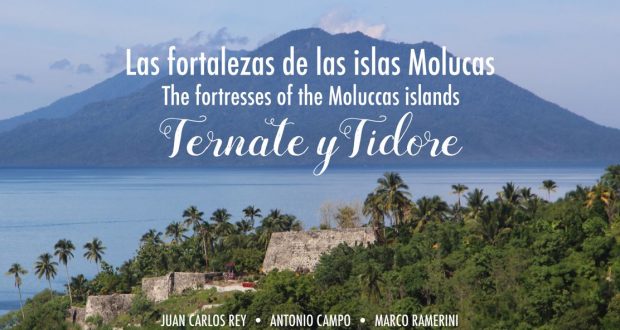
A splendid book dedicated to the spice islands was published in April 2022. The book describes in detail the fortifications of the two islands of Ternate and Tidore in the Moluccas, the famous Spice Islands. The text of the book is bilingual in Spanish and English. From the book cover: “This book offers a precise and detailed account of every ...
Read More »
Books, Indonesia, Philippines, Portuguese Colonialism, Spanish Colonialism
690 Views
On the occasion of the celebrations of the 500th anniversary of Ferdinando Magellano’s first trip around the world. A new book about the Spice Islands has just been published by the Spanish publishing house Desperta-Ferro, specialized in Spanish military history. It is a large format book (384 pages, 189 x 246 mm), and includes old maps. I had the honor ...
Read More »
Indonesia, Moluccas, Philippines, Portuguese Colonialism, Spanish Colonialism
1,757 Views
The Spaniards in the Moluccas: 1606-1663/1671-1677. The history of the Spanish presence in the spice islands Written by Marco Ramerini. 2005-2020/23 INTRODUCTION In the early 2000s I had started researching the Spanish presence in the Spice Islands. Some of my research was published during those years. The largest, however, remained unfinished in the files on my computer. Now after 15 ...
Read More »
Indonesia, Moluccas, Philippines, Portuguese Colonialism, Spanish Colonialism
1,436 Views
The Spaniards in the Moluccas: 1606-1663/1671-1677. The history of the Spanish presence in the spice islands Written by Marco Ramerini. 2005-2020/23 CHAPTER TWO: THE CONQUEST OF TERNATE THE PREPARATION OF THE EXPEDITION BY D. PEDRO DE ACUÑA The Spanish response, this time, was not long in coming. The governor of the Philippines, D. Pedro de Acuña, in a document1, undated, ...
Read More »
Indonesia, Moluccas, Philippines, Spanish Colonialism
727 Views
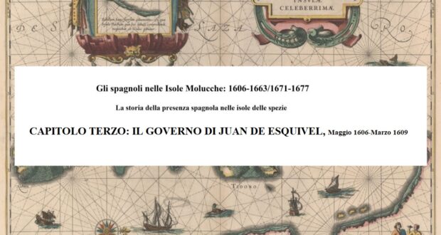
The Spaniards in the Moluccas: 1606-1663/1671-1677. The history of the Spanish presence in the spice islands Written by Marco Ramerini. 2005-2020/23 CHAPTER THREE: THE GOVERNMENT OF JUAN DE ESQUIVEL, May 1606-March 1609 Governor Acuña, after conquering Ternate, left for Manila on May 3, 1606, where he arrived on June 2, 1606. Before leaving Ternate, he appointed the “mestre de campo” ...
Read More »
Indonesia, Moluccas, Philippines, Spanish Colonialism
485 Views
The Spaniards in the Moluccas: 1606-1663/1671-1677. The history of the Spanish presence in the spice islands Written by Marco Ramerini 2005-2020/23 CHAPTER FOUR: THE GOVERNMENT OF LUCAS VERGARA GABIRIA (who performs the functions), March 1609-February 1610 THE APPOINTMENT OF LUCAS VERGARA GABIRIA AS GOVERNOR OF TERNATE At the beginning of 1609, on the death of Juan de Esquivel, Lucas Vergara ...
Read More »
Indonesia, Moluccas, Philippines, Spanish Colonialism
562 Views
The Spaniards in the Moluccas: 1606-1663/1671-1677. The history of the Spanish presence in the spice islands Written by Marco Ramerini. 2005-2020/23 THE ARRIVAL OF CRISTÓBAL DE AZCUETA MENCHACA IN TERNATE The new governor of Ternate, the “mestre de campo” Cristóbal de Azcueta Menchaca, was appointed by the governor of the Philippines Don Juan de Silva.1 On February 4, 1610 we ...
Read More »
Indonesia, Moluccas, Philippines, Spanish Colonialism
624 Views
The Spaniards in the Moluccas: 1606-1663/1671-1677. The history of the Spanish presence in the spice islands Written by Marco Ramerini. 2005-2020/23 CHAPTER SIX: THE GOVERNMENT OF D. JERÓNIMO DE SILVA, March 1612-April 1617 THE ARRIVAL OF D. JERÓNIMO DE SILVA IN TERNATE In the first months of 1612 several ships arrived in Ternate to reinforce the Spanish garrisons in the ...
Read More »
Indonesia, Moluccas, Philippines, Spanish Colonialism
481 Views
The Spaniards in the Moluccas: 1606-1663/1671-1677. The history of the Spanish presence in the spice islands Written by Marco Ramerini. 2005-2020/23 CHAPTER SEVEN: THE GOVERNMENT OF LUCAS VERGARA GABIRIA, April 1617-February 1620 THE ARRIVAL OF LUCAS VERGARA GABIRIA IN TERNATE In April 1617 a galley was sent from Manila to warn Don Jeronimo of the new events1 and to inform ...
Read More »
Indonesia, Moluccas, Philippines, Spanish Colonialism
464 Views
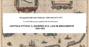
The Spaniards in the Moluccas: 1606-1663/1671-1677. The history of the Spanish presence in the spice islands Written by Marco Ramerini. 2005-2020/23 CHAPTER EIGHT: THE GOVERNMENT OF D. LUIS DE BRACAMONTE, February 1620-1623 THE ARRIVAL OF D. LUIS DE BRACAMONTE IN TERNATE The new governor D. Luis de Bracamonte arrived in Ternate on February 10, 1620, with a fleet including 2 ...
Read More »
Indonesia, Moluccas, Philippines, Spanish Colonialism
422 Views
The Spaniards in the Moluccas: 1606-1663/1671-1677. The history of the Spanish presence in the spice islands Written by Marco Ramerini. 2005-2020/23 CHAPTER NINE: THE GOVERNMENT OF PEDRO DE HEREDIA, February 1623-1636 THE ARRIVAL OF PEDRO DE HEREDIA IN TERNATE Pedro de Heredia was a veteran of the Moluccas, and as governor he will set a record of tenure as he ...
Read More »
Indonesia, Moluccas, Philippines, Spanish Colonialism
370 Views
The Spaniards in the Moluccas: 1606-1663/1671-1677. The history of the Spanish presence in the spice islands Written by Marco Ramerini. 2005-2020/23 CHAPTER TEN: THE GOVERNMENT OF PEDRO MUÑOZ DE CARMONA Y MENDIOLA, March 1636-January 1640 THE ARRIVAL OF PEDRO MUÑOZ DE CARMONA Y MENDIOLA IN TERNATE The new governor of Ternate D. Pedro Muñoz de Carmona y Mendiola, appointed “alcayde”, ...
Read More »
Indonesia, Moluccas, Philippines, Spanish Colonialism
530 Views
The Spaniards in the Moluccas: 1606-1663/1671-1677. The history of the Spanish presence in the spice islands Written by Marco Ramerini. 2005-2020/23 CHAPTER ELEVEN: THE LAST SPANISH GOVERNORS OF TERNATE, 1640-1663 D. FRANCISCO SUÁREZ DE FIGUEROA Y ACEVEDO, January 1640-1642 The new governor D. Francisco Suarez de Figueroa had left Spain for the Philippines in 1608 together with D. Juan de ...
Read More »
Indonesia, Moluccas, Philippines, Spanish Bibliographies, Spanish Colonialism
668 Views
The Spaniards in the Moluccas: 1606-1663/1671-1677. The history of the Spanish presence in the spice islands Written by Marco Ramerini. 2005-2020/23 INDEX 1: The first contacts of the Spaniards with the Moluccas2: The conquest of Ternate3: The government of Juan de Esquivel, May 1606-March 16094: The government of Lucas de Vergara Gabiria (acting the functions), March 1609-February 16105: The government of Cristóbal de Azcueta ...
Read More »
Indonesia, Moluccas, Spanish Colonialism
112 Views
An interesting study has just been published regarding the latest Spanish presence in the Maluku Islands, it is the paper entitled “1677: el Fuerte de Santa Rosa en la isla de Siau, última presencia española en Indonesia”. The document is written by three leading researchers of the Spanish presence in the Maluku Islands: Antonio Campo López, Juan Carlos Rey and ...
Read More »
Asia, Indonesia, Moluccas, Philippines, Spanish Colonialism
1,351 Views
Written by Marco Ramerini – 2021 In 1618, three very bright comets were visible in Europe in the space of a few months. A very rare event, which we approached in 1996-1997 with the two spectacular end-of-the-century comets: Hyakutake and the even more spectacular Hale-Bopp, which was visible to the naked eye for 18 months. The three comets of 1618 ...
Read More »
Indonesia, Moluccas, Spanish Colonialism
3,618 Views
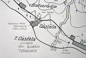
Written by Marco Ramerini. English text revision by Dietrich Köster. Ternate, Terrenate, Thernate, Gamolamo, Ciudad del Rosario (or Rrosario), Gamma Lamma1 : (Current name: Kastela, Benteng Kastela o Kastella) (Under Spanish control: 1 April 1606-1663) The Spanish city of Ternate was in the southern part of the island, in the place now called Kastela, where, since 1521, were established the ...
Read More »
Indonesia, Moluccas, Spanish Colonialism
1,531 Views
Written by Marco Ramerini. English text revision by Dietrich Köster. San Pedro, Sant Pedro, Fuerza Nueva: (1606/1610-1663) benteng Santo Pedro (Kastella) Among the defenses of the Spanish city of Ternate: Ciudad del Rosario. There was also a fort set on a hill in the surroundings of the city. This fort was called San Pedro. It seems that the Portuguese had ...
Read More »
Indonesia, Mexico, Moluccas, Philippines, Spanish Colonialism
652 Views
Written by Marco Ramerini, 2005-2021 (English translation: 2023) General index THE FAILED EXPEDITIONS TO ALGIERS 3 FIRST EXPEDITION TO ALGIERS 4 SECOND EXPEDITION TO ALGIERS 9 THE MOLUCCAS 10 THE CONQUIST OF TERNATE AND THE MOLUCCAS 10 THE EXPEDITION TO MALACCA 15 THE PHILIPPINES 18 THE YUCATAN 20 FIRST TERM OF GOVERNOR 20 SECOND TERM OF GOVERNOR 22 THE WIDOW ...
Read More »
Dutch Colonialism, Indonesia, Moluccas, Portuguese Colonialism, Spanish Colonialism
857 Views
Written by Marco Ramerini, 2005 (English edition: 2023) In this text I describe the information I have gathered over the years regarding the Spanish outposts in the peripheral islands of the Moluccas, therefore excluding the islands of Ternate and Tidore. Spanish control, in fact, was not limited only to the two main islands of Tidore and Ternate, which are treated ...
Read More »