Categories
Portuguese Colonialism Zimbabwe

Makaha: Portuguese Settlement, Market (Feira) in Zimbabwe

Written by Chris Dunbar. All pictures are copyright by Chris Dunbar.

The trip to find the site of Makaha was via the town of Mutoko and then on a dirt road for 90 minutes into the growth point of Makaha. Once we left the growth point we had to resort to four wheel driving as the road turned to a track and became very treacherous due the massive amount of illegal gold mining and the trenches and holes that the illegal miners had dug. Again as with my trip to find Maramuca I was offered gold dust at every illegal gold mine.

The location of this site is about five kilometres from the Ruenya River and while in the 1950’s the outer walls were still visible when I did find the site once again every thing had been obliterated by the illegal gold miners.

I discussed this particular site with a number of the staff from the Museums and with a number of interested parties, all agreed that this site was not actually Portuguese or at least there was very little evidence to show that it was settled by the Portuguese.

The excavations while only on a very minor scale failed to provide any further evidence of a Portuguese presence. The claim to it being Portuguese are based off a very old miners claim (1945) that he had found an earthwork similar to the ones on the Angwa River also documented in 1945.

In order for me to wonder around the bush near Makaha I had to gain permission from the local village elder and the local political commissioner and with their help I was taken to two very interesting sites, it was claimed that both sites were of Portuguese origin.

The first site was on top of a hill and was constructed of schist and was very clearly “native” I worked at the site for a number of hours and only found “native” pottery shards.

The second site was truly fantastic the walls and turrets were still standing, without the aid of cement. The outlines of the rooms were evident and the tree that was growing in the walls was at least 100 years but again I think it was too structured and when I looked on the map from the National Monuments I could not find any reference to it at all. I found no sign of Portuguese presence.

This site was north east of the Makaha site only about 2km’s. The walls are pretty much as is there were no scattered stones so the walls are close to their original height. The walls circled the top of the hill. The defensive line was probably 200 metres in circumference in the middle of the “fort” was a slight depression which I was told was were the white people of old (the village elder claimed Portuguese) had lived and to the left of that depression was a very deep shaft cut into the schist and that was a “gold” vein and the walls had been built to defend that “gold” vein. The entrance (there was only one) is clearly visible.

The elder claimed that this was a Portuguese site, to me it is clearly a stone “zimbabwe” I did not have the time to excavate, I did look at the construction and the surrounds, I was taken to number of large holes in the ground on the southern side of the hill about twenty metres below the summit and the walls and the holes were laid out in a definite pattern, the village elder said that these were graves. Now, when I sat with the village elder a few hours later and shared some water, he told me that he had only been in the area for 70 years, Makaha was well known to him as Portuguese, no Portuguese artefacts have been found and not even Blue on White Chinese Porcelain shards have been found. I think that over the years interested parties like me have come looking for the Portuguese site and he has heard the rumours and put them altogether in a jumbled story. The ruins on the hill, oral tradition states that these are Portuguese in origin. I would hazard that they were a defensive site to protect the local villages from the Portuguese.

What I did find interesting was a rumour that close to the supposed site of Makaha was a grave yard with headstones and inscriptions of Portuguese who had died in the area. I did not have time to follow this up but may make this a separate project for next year.

[divider]

[divider]

MAKAHA: EARLY SETTLERS HOUSE

Written by Chris Dunbar. All pictures are copyright by Chris Dunbar.

This one, I have called old settlers house. Truly I do not know who built it, I could not find it logged on the museums and monuments records.

To me after visiting Luanze, Angwa, and looking at the plans for Maramuca I just cannot bring myself to say that it is of Portuguese early origin. It is too structured and I have included pictures of the room layouts and of the “porch” layout. The walls were once very high, as can be seen using me as the height measurement.

The wall stones that have fallen are missing, not scattered so they have been carried away for another structure, I walked all over this hill and found no structures near by so they have been moved some distance away. There are a number of large trees in the house, and the type of tree suggests that they are at least 100 years old.

The village elder again claimed that this was Portuguese and he stated categorically that I was the first white man that he knew of that had visited it in all the time that he had been in the area (70 years). I was unable to excavate but after some grass clearing and surface searching I did not find anything at all to give me a datum. No pottery, no glass nothing.

The walls are made from local rock slabs not schist as per the other site, a completely different rock strata was in this area which was north east of the Makaha site 4 km’s and probably only 2 km’s from the other schist walled site. The stones are held in place with daga / mud, no cement or concrete at all. I imagined that there must have been timber trusses for the roof (no evidence found) the hill was well wooded but the type of trees growing are not the type to grown straight so maybe straight trunks were carted in.

This is the summary from the man who went looking for the Portuguese grave stones, in Makaha:

It is very sad to hear about the fate of the feiras and I suspect many other national monuments. I hope I may be able to explain the story of the headstones. It has been preserved, I suspect, by a paragraph in a Henk Ellert’s book, Rivers of Gold which quotes me saying I had heard of such things and spent some time looking for them, both of which are true. In the 1960s when I worked in the Honde Valley I was invited by a young Carmelite priest to do a tour of the north of the province which I had never been to. One night we stayed at Katere – I think the mission was called Regina Coeli – where the missionary was a tough but charming man called Senan Egan. He did a lot of prospecting and hunting apart from running a very successful mission-farm and said that across the river (Ruenya) he had found the gable end of a church and head stones with inscriptions, both of which he took to be Portuguese. He said tsetse officers had seen them in the same area. I resolved to go and have a look one day. Then the war happened. It was the 80s before I got back. I went with Chuck Bollong, the new archaeologist at QVM and my wife. I located Fr. Egan who gave us directions but was by now too old to come too. We spent a couple of days there but apart from meeting a lot of panners and a highly eccentric family of prospectors, all we found was some ruins of German mining endeavours from the early 20th century.

My next attempt was a couple of years later with Professor (Dave) Beach of UZ. This time we came in from the Mutoko side and hit the Makaha Feira straight away. In those days it was quite recognisable and even had a National Monuments sign on it. We spent another couple of days with the prospector but just found more of the German stuff. My conclusion after this was that what Fr Egan and the tsetse people had seen was early 20th century. This area was of course what Karl Mauch named the Kaiser Wilhelm gold field and there was a lot of early German interest. The prospector told us he had found an early Mercedes in the bush too but I am sceptical! So I think the feira is the only extant Portuguese site. What I saw was the remains of a strong point, square with star bastions on the corner. There was also a curtain wall at the entrance, but I suspect that was a later addition. There were some quite deep shafts near by.

The German miners settlement is at 1720’06.90″s and 3246’09.33″e on Google Earth, below that is the schist stone iron age settlement that I found also pictures on Google Earth and about five kilometres towards the big river (Ruenya) is the Feira of Makaha which I never found.

[divider]

[divider]

Categories
Portuguese Colonialism Zimbabwe

Luanze: Portuguese Settlement, Market (Feira) and Fort in Zimbabwe

Written by Chris Dunbar. All pictures are copyright by Chris Dunbar.

The Fort of Luanze, where the Portuguese hold a market, is in the lands of Mocaranga, forty leagues from Tete…..this fort has a church, served by a dominican friar who administrates the sacraments to the christians who dwell there or pass through. Pedro Barreto de Rezende, 1634.

I then went to Luanze which is about 450 km’s from the Piringani site and about 20 km’s short of the Mozambique border. I had with me a member of the Department of National Monuments as a guide and facilitator.

The remains of the houses built by the Portuguese traders are no longer visible but are indicated by a series of stone markers placed by the archaeologists that excavated the site in the 1960’s. The stone walls built by the local natives that co habited the site with the Portuguese traders are still very evident and the stream that started the trade in alluvial gold, was just evident. It was very difficult to picture the site as the vegetation has taken over but it was possible to walk along the walls that were built as barricades and protection. While in the trade square it was relatively (and surprising so) easy to pick up trade beads and shards of Chinese pottery that the Portuguese used to barter for gold and ivory.

Once you crossed the tar sealed road at the modern way stop (Masarakufa) it took a bit of looking to locate the site of the Dominican Church, but did find it as it is marked by a plinth placed by the Department of National Monuments. It is regrettably in a very poor state of repair, I had to clear some of the bush and grass as it was over my head, to find the foundations. The floor while once compacted and level is far from that today, the walls are only inches high but it is still possible to see the outline of the wooden poles imprinted into the mud, that was used for the walls and support structures for this church in 1634, it was incredible.

In Mtoko there is a little museum built to house the artefacts un-earthed at the Luanze Feira.

I attempted to go through Luanze to get to Makaha but there is no viable route any more so I tried to go via Kamoto but I was advised that the route was too long and arduous for the time I had allocated to this visit.

[divider]

[divider]

Revisited Luanze and gained permission to do some clean up/restoration on the site.

I worked with one local African with an axe and a grass cutter it took us the whole day to clear the church site, we cut the grass and cut the trees then killed the stumps.

In the Earthwork 2 around the remains of the three Portuguese houses we cut the grass and removed the trees, we tried to remove the ant mounds and lift some of the fallen stone markers but time was now running short.

The fact that two of us cleared and cleaned these two small areas probably means that the site will remain visible for a number of extra years.

Earthwork 1 the larger of the two I was not able to do anything with, I did walk over to visit it but as Earthwork 2 has more tangible visual remains decided to spend my time attempting to preserve those remains.

[divider]

[divider]

BIBLIOGRAPHY:

– Ferreira, A. Rita “African kingdoms and alien settlements in Central Mozambique (c. 15th-17th Cent.)” 172 pp. Departamento de antropologia, Universidade de Coimbra, 1999, Coimbra, Portugal.

– Garlake, P. S. ” Seventeenth century Portuguese earthworks in Rhodesia” In: “South African Arch. Bull.” n° 84, 1966, pp. 157-170

– Newitt, M.D.D. “Portuguese settlement on the Zambese: Exploration, Land Tenure & Colonial Rule in East Africa” 434 pp. Maps, illus.& plates. Longmans, 1973, London, UK.

– Rea Francis, W. “The economics of the Zambezi missions, 1580-1759” 189 pp. Institutum Historicum S. I., 1976, Roma, Italia.

Categories
Portuguese Colonialism Zimbabwe

Dambarare: a Portuguese Settlement, Market (Feira) and Fort in Zimbabwe

Written by Chris Dunbar. All pictures are copyright by Chris Dunbar.

This site is scattered over a very wide area and was a large settlement (Dambarare covers about 6 square km’s), one of the largest Earthworks numbered 2 was flooded when the Jumbo Mine Dam was built, a great shame as while a little excavation work was done the Professor that I spoke with told me that only 2% of the site was studied so truly a great wealth of possible finds lost for ever.

I looked and searched and was very disappointed with the lack of success, I have a few pictures but only one worth anything, it shows a small hill where a very minor earthwork was situated, it was never excavated and all surface remains have gone.

[divider]

[divider]

These pictures are from the “Ancient workings” very near the sites of Dambarare. They were dug before the Portuguese arrived but were a draw card for the Portuguese to settle in the area, I have a lot about Dambarare but was unable to locate any of the actual earthworks despite extensive looking.

[divider]

[divider]

After the sacking of Dambarare in 1693, it is believed that some of the military loot was moved to the site of Dhlo Dhlo. This was either an attempt to elevate the local king’s status amongst his vassals, or as a trade bargaining chip by the sacker of Dambarare. The canons when found showed that they could not have been fired, after they were removed from Dambarare. They are currently outside the presidential residence in South Africa.

[divider]

[divider]

DAMBARARE EARTHWORKS

DAMBARARE EARTHWORK 1:

This is where Professor Garlake focused his excavation efforts. Amazing to think that under here are up to 1000 Portuguese men and women, soldiers and priests buried awaiting discovery.

[divider]

[divider]

22 is a picture of the site in general the actual earthwork would have been behind the tree in the centre of the picture and would have covered most of that rise as it was quite large. 540 feet x 270 feet.

9, 11 are general shoots from within the fort / earthwork surrounds.

18 is where I locate the church mound seen on figure 2a.

Figure 2a is the shape the earthwork would have taken

32 and 33 are front and back pottery shards found on the surface inside the Earthwork 1.

31 is a guyo grinding stone for crushing gold bearing ore found at the site.

[divider]

[divider]

DAMBARARE EARTHWORK 3:

No visable surface remains but this site was on the edge of this hill overlooking the valley. Earthwork 4, 2 and 1 would have been visable from this earthwork. In my opinion Earhwork 5 would have been too far away to have been visable.

[divider]

[divider]

DAMBARARE EARTHWORK 4:

When Jumbo Mine Dam was made in the 90’s it flooded Earthwork 4. The best of the feiras, it still had the walls etc, but now consigned to history.

[divider]

[divider]

DAMBARARE, ZIMBABWE: CHURCH GRAVES SKETCHES

Sketches by P. S. Garlake. Historical Monuments Commission, Salisbury.

[divider]

[divider]

BIBLIOGRAPHY:

– Various Authors “Documentos sobre os portugueses em Moçambique e na Africa central, 1497-1840. Documents on the Portuguese in Mozambique and Central Africa, 1497-1840” National Archives of Rhodesia and Nyasaland, Centro de Estudos Históricos Ultramarinos, 1962-(1989), Lisboa. Includes indexes. “The sources have been drawn from archives and libraries in Portugal, Italy, France and other countries … Published in the original with an English translation. Contents: v. 1. 1497-1506.–v. 2. 1507-1510.–v. 3. 1511-1514.–v. 4. 1515-1516.–v. 5. 1517-1518.–v. 6. 1519-1537.–v. 7. 1540-1560.–v. 8. 1561-1588.–v. 9. 1589-1615.

– Axelson, Eric “Portuguese settlement in the interior of South-East Africa in the seventeenth century” 17, [1] p. ; Sep. Actas Congresso Internacional História dos Descobrimentos, 5, 1961, Lisboa.

– Axelson, Eric “Portuguese in South-East Africa, 1488-1600” 276 pp. Struik, 1973, Cape Town, S.A.

– Axelson, Eric “Portuguese in South-East Africa, 1600-1700” x + 226 pp. Witwatersrand University Press, 1969, Johannesburg, S.A.

– Ferreira, A. Rita “African kingdoms and alien settlements in Central Mozambique (c. 15th-17th Cent.)” 172 pp. Departamento de antropologia, Universidade de Coimbra, 1999, Coimbra, Portugal.

– Garlake, P. S. “Seventeenth century Portuguese earthworks in Rhodesia” In: “South African Arch. Bull.” n° 84, 1966, pp. 157-170

– Newitt, M.D.D. “Portuguese settlement on the Zambese: Exploration, Land Tenure & Colonial Rule in East Africa” 434 pp. Maps, illus.& plates. Longmans, 1973, London, UK.

– Newitt, Malyn D.D. “A History of Mozambique” 679 pp. maps Hurst and Company, 1995, London, UK.

– Newitt, M.D.D. “The Portuguese on the Zambesi from the Seventeenth to the Nineteenth Centuries” In: “An expanding world” vol. n° 25 “Settlement patterns in early modern colonization, 16th-18th centuries” pp. 279-300 Ashgate Variorum, 1998 In: Race IX, n° 4, pp. 477-498 Institute of Race Relations, 1968, London,

– Newitt, M.D.D. “The Portuguese on the Zambesi: an historical interpretation of the Prazo system” In: “An Expanding World” Vol. n° 4; Disney, A. “Historiorgraphy of Europeans in Africa and Asia 1450-1800” Ashgate Variorum, vol. n° 4, 1995; pp. 155-173 Also in: “Journal of African History” vol.10, n°1, 1969, Cambridge, pp. 67-85

– Rea Francis, W. “The economics of the Zambezi missions, 1580-1759” 189 pp. Institutum Historicum S. I., 1976, Roma, Italia.

– Strandes, J. “The Portuguese period in East Africa” xii, 325 pp., 5 plates, folding map, Edited by J. S. Kirkman, 1968, Nairobi, Kenya.

Categories
Asia Dutch Colonialism

The Dutch West India Company. WIC (West-Indische Compagnie)

Written by Marco Ramerini. English text revision by Dietrich Köster.

The WIC (West-Indische Compagnie) Dutch West India Company was a Dutch trading company shaped after the example of the VOC (Vereenigde Oostindische Compagnie – Dutch East India Company). On June 3, 1621 it was granted a charter for the ‘right on shipping and trade’ and a 24 years monopoly of trade and navigation, conquest and commerce in the West by the Staten Generaal of the United Provinces of the Netherlands.

The WIC was authorized to make alliances with the natives of West Africa, America and the Pacific islands east of New Guinea; to build fortresses, maintain troops, garrisons and fleets. The area, where the company operated, was West Africa (the area between the Tropic of Cancer and the Cape of Good Hope) and the Americas (including the Pacific Ocean).

The company had five offices, called kamers: Amsterdam, Zeeland (Middelburg), Maze (Rotterdam), Noorderkwartier (Hoorn) and Stad en Lande (Groningen). The board consisted of 19 members, known as the Heeren XIX. The Heren XIX consisted of 8 representatives from Amsterdam, 4 from Zeeland and 2 from Maze, 2 from Noorderkwartier and 2 from Stad en Lande, the Staten Generaal had 1 representative. The Heeren XIX were to meet alternately in Amsterdam for six years and at Middelburg for two.

Map of the main WIC settlements in the Atlantic Ocean (1640s.1650s.). Author Marco Ramerini

In the first years the company had a very aggressive conduct. The WIC was used in the Western Hemisphere by the Staten-Generaal as a military force in their war against Spain and Portugal, just as the VOC in the Eastern Hemisphere. In 1624 the WIC attacked and conquered the capital of Portuguese Brazil Salvador da Bahia. This town remains under Dutch control for a year (1624-1625), when a Portuguese-Spanish fleet retook it. During the 1620s several colonies were founded in North America (New Amsterdam, actual New York; Fort Orange, actual Albany).

In 1630 the WIC did a more durable conquest in Brazil: Dutch troops occupied Recife and Olinda in the capitanacy of Pernambuco. In the next years during the government of Johan Maurits von Nassau-Siegen, the Dutch control over Brazil extended to the coast between São Luis do Maranhão to the North until Sergipe del Rey to the South, pratically half of Brazil and thus the more prosperous part of it was under WIC control.

The apex of the WIC power was reached during 1640-1645. At that time the company controlled New Netherland (part of the present-day States of New York and Delaware, New Holland (part of Brazil), Curaçao, Aruba, Tobago and several other islands in the Caribbean, Guyana and Suriname, Fernando de Noronha, several forts along the African coast in Mauritania (Arguin), Senegal (Gorée), Ghana (Elmina, Axim, Mouree etc….), São Tomé and Anobom islands, Angola (Luanda and Benguela). For a few months a Dutch expedition occupied Valdivia and Chiloé in Chile in 1643, too.

(Map of the WIC Empire in the Atlantic.)

Then the things went wrong: Johan Maurits van Nassau-Siegen was called home and the Portuguese “moradores” rebelled against the WIC rule, after a long warfare a Portuguese armada retook Recife and the whole Dutch Brazil in 1654. In 1664, the English occuped New Amsterdam and renamed it New York. The WIC quickly declined until the Company was liquidated in 1674.

A new WIC was launched shortly after in 1675. Until 1743 this WIC maintained part of the original monopolies: the trading of African slaves and products such as gold. Afterwards the WIC was exclusively engaged in the administration of the remaining African and American overseas territories and fortresses until the Company was definitively dissolved in 1791.

BIBLIOGRAPHY:

– Boxer, Ch. R. “The Dutch in Brazil, 1624-1654” Oxford, 1957

– Boxer, CH.R., “The Dutch Seaborne Empire, 1600-1800” London, 1965

– Boxer, Ch. R. “Salvador de Sá and the struggle for Brazil and Angola, 1602-1686” London, 1952

Categories
Oceania Portuguese Colonialism

Bittangabee Bay ruins, Australia

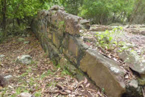
Text and Photos by Jones Matos da Silva

Bittangabee Bay is located in Ben Boyd National Park to the south of the coastal town of Eden along the south coast of New South Wales, Australia. These ruins are claimed by Kenneth McIntyre to be of Portuguese origin.

I drove there last month and took me 8 hours drive from Sydney (480 km), south towards Melbourne. It was not difficult to access the bay, it is well signed and even that the last 18 km to the bay are unsealed road the drive is quite pleasant.

These ruins are quite controversial, no one has really approach a conclusion of what they are, as a example, Gavin Menzies in his ‘1421’ consider it a Chinese construction.

I had seen ruins of Portuguese forts in Brazil and I can say that this is not a fort, but, the footprint reminding me of the old colonial houses in Brazil up to the 17th century, but sure, this is only a first impression.

According to Michael Pearson the ruins are not of Portuguese origin, in his studies he date back the ruins to the nineteenth century. Precisely the remains have been dated to 1844.

BIBLIOGRAPHY:

– Kenneth Gordon McIntyre “The Secret Discovery of Australia – Portuguese ventures 200 years before Captain Cook” Souvenir Press, 1977.

– Trickett, P. “Beyond Capricorn. How Portuguese adventurers discovered and mapped Australia and New Zealand 250 years before Captain Cook” 2007, East St. Publications. Adelaide

Categories
Dutch Colonialism Oceania

Australia and the Dutch East India Company (VOC)

Written by Peter Reynders

There have been a number of early European based ‘monopoly companies’ trading in Asia. The combined impact of the Portuguese Estado da India, the first practitioner of the monopoly product principle, the Muscovy, the Ostend, the Swedish and the English East India Companies, the VOC (Dutch East India Company) and the many smaller enterprises of the vast, old and highly developed intra-Asian trading network is often overstated. The few percentage points of the total Asian economic turnover that went to Europe and the number of European people living and trading in Asia compared to the Asian population was relatively insignificant in the two centuries of the VOC. None of the activities of these companies, however, is as significant as the role the VOC played in Australian’s early maritime history, because it was the VOC that made the Southland’s existence known to the world. It first placed our continent on the world map enabling better known mariners such as Dampier, Cook and Flinders to enter the story.

Of the 54 recorded European ships that sailed into Australian waters before 1770, 42 were VOC ships. “Sloepie” the first ship built here by Europeans, was built by a shipwrecked VOC crew. Our first European immigrants, Wouter Loos and Jan Pelgrom De Bye, convicted criminals, dropped off on the mainland in 1629, were VOC employees. The first armed conflict on land in our history between two groups of whites was between a VOC crew and its mutineers. The first recorded white ‘Southland baby’ was born aboard a VOC ship moored on our coast. The first recorded Europeans to chart part of our coast were Captain Willem Janszoon and his crew in Duyfken a small vessel bought second hand for ƒ 2200, heralding the beginning of our written history in 1606. The first recorded navigator to circumnavigate our continent and first prove that it is an island, and that it must have an east coast, lead the VOC’s exploratory forays. His name was Abel Tasman. The first pictures drawn by Europeans of our coast and of some of our wildlife were by artists aboard VOC ships.

That is not to suggest that the London based East India Company (EIC) has no connection with early Australian history. Our first European shipwreck, on the coast of Western Australia in 1622, the Tryall, was an EIC ship skippered by John Brookes. Like the Batavia, it too ended up as a horror story, but less heroic, less complicated, less well known.

With the exception of Captain Gonzal, who provided enthusiastic reports about this continent and its people, VOC captains invariably reported unfavourably on the trading potential with Aboriginal peoples. ‘Too poor to dress themselves’, ‘most miserable creatures on earth’ they would write in their logs. The VOC, having visited, sought trade, searched for their own shipwrecked vessels and tried to chart dangerous coastal features during the 17th century, did not deliberately return at all, apart from Gonzal in 1756, during the 18th century, arriving when they did only by accident.

Australians on the east coast know little about the VOC. In 2006 it was 400 years since it began our written history, in fact in early 1606 the Dutch explorer Willem Janszoon encountered and then charted the shores of Australia’s Cape York Peninsula. But many historians, researchers, educational bodies and media rely on Britsh sources in telling our story. Our national TV broadcasters usually focus on British history when it comes to our beginnings, often without even offering an Australian viewpoint. We watch Henry VIII and his wives, Elizabeth I, the Battle of Hastings, discuss the Magna Carta, as if they are relevant here, etc. but they hardly constitute our own early history. There are ABC programs on such things as the 400th anniversary of Guy Fawkes’ “Gunpowder Plot”, interesting but rather irrelevant to our history. In 1602, no Englishman, including Guy Fawkes, had ever heard of this Southland, other than perhaps as a legend. Yet in 2002 there was not a single program about the 400th anniversary of the founding of the VOC, the body that revealed Australia to the world.

BIBLIOGRAPHY:

– Godard, Philippe “First and Last Voyage of the Batavia” 332 pp.

– Playford, Phillip “Voyage of Discovery to Terra Australis” 113 pp. Willem de Vlamingh’s intrepid voyage to Australia 1696-1697

– Playford, Phillip “The Wreck of the Zuytdorp” 36 pp. West Australian Historical Society

– Playford, Phillip “Carpet of silver: the wreck of the Zuytdorp” xii, 260 pages, University of Western Australia Press, 1996-1998, Perth, Australia.

– Sigmond, J. P. and Zuiderbaan, L. H. “Dutch discoveries of Australia: shipwrecks, treasures and early voyages off the West Coast” 176 pp. ills. 1979 (1st English edition of the 1976 original Dutch title “Nederlanders Ontdekken Australie”), Adelaide, Australia.

– Tooley, Ronald Vere “Early maps of Australia The Dutch Period” 27 pp. 30 illus. Map Collectors’ Circle, 1965, London, UK. Examples from the collection of R.V. Tooley with bibliographical notes.

Categories
French Colonialism Oceania

Isle of Pines: Prison ruins and Cemetery of the Deported (Cemetery of the Communards) in New Caledonia

Written by Marco Ramerini. English text revision by Dietrich Köster.

Located south-east of Grande Terre (New Caledonia), the Isle of Pines is a small island full of natural wonders, endless white beaches and crystal clear water, caves and caverns, rich coral reef, natural wonders like the natural pool (piscine naturelle) with seawater, inhabited by a friendly population with rich traditions.

This enchanted island 14 km wide and 18 km long has a turbulent history. It was on this land of paradise that the protesters of the Paris Commune among other prisoners were exiled in the 19th century. Today the remains of the 19th-century buildings are touching witnesses to this period.

In 1872 the island became a French penal colony, home to 3,000 political deportees from the Paris Commune. The deportees were allocated to five different areas around the island, the most notable of which is that of Ouro. This is where you find the ruins of the penal colony, invaded by tropical vegetation. A little further upstream is the Cemetery of the Deportees (Cimetière des Déportés).

These places of sadness are just a few hundred metres away from the white sandy beaches of Kanumera and Kuto, two of the most fascinating places on the island.

[divider]

[divider]

Categories
French Colonialism Oceania

Fort Teremba: a prison for deportees in New Caledonia (Grande Terre)

Written by Marco Ramerini. English text revision by Dietrich Köster.

This fort is situated between La Foa and Bourail, 124 kilometers north of Nouméa.

In 1871 a group of 25 convicts, 2 wardens, 3 gendarmes and the head of the topographical department set up a camp on the left bank of La Foa river near the Kanak village of Uarai, later that year the camp was moved to a better site on the right bank of the river on a little hill.

This small camp was enlarged between 1871 and 1877 through the construction of several buildings: water tanks, cells, huts for military troops and for the convicts, the commander’s house, a chapel, some workshops and warehouses, a school, a bakery, an infirmary, a telegraph station, an anchorage etc..

The fort was built after the Kanak insurrection of 1878. Inside the perimeter of the walls were built a blockhouse, a watchtower and a prison. The number of the convicts was between 120 and 300, some of them worked at the farm penitentiary of Fonwhary, situated 8 kilometers away on a fertile and well irrigated land.

The settlement of Teremba was damaged by a cyclone in 1898.

In 1984 the Association Marguerite attempted to make Teremba a place of living memory. In 1989 the site was classified as historical monument. In 1992 the first buildings were restored. The site has actually a little museum and it is open Tuesday to Sunday from 9 AM to 4 PM, admission fee: 250 CFP.

Categories
Oceania Russian Colonialism

Russian presence in Hawaii. Russian forts and settlements in Hawaii

Written by Marco Ramerini. English text revision by Dietrich Köster.

In the early 19th century Russian fur traders established trading centers from Siberia into the North American subcontinent, Russian cargo vessels regularly transecting the northern Pacific Ocean. In January 1815 a Russian-American Company vessel, named “Bering”, that traded furs for food throughout the Hawaiian Islands, was shipwrecked at Waimea, Kauai. The ship and the cargo were confiscated by Kaumualii, king of Kauai. Subsequently the Russian-American Company sent an agent, Georg Anton Schäffer (a German surgeon of one of the Company’s vessels), to diplomatically recover the company’s lost properties.

Schäffer’s mission was to gain the confidence of Kamehameha I, who had acknowledged the right to sovereignty of Kaumalii in 1810. Once the bond existed between Schäffer and Kamehameha I, he was to reveal the true character of his mission and requested Kamehameha’s assistance in securing compensation from Kaumualii for the confiscated cargo. Despite opposition from a group of American traders, who had gained Kamehameha’s trust. By early 1816 Schäffer had been successful in obtaining fishing rights, livestock and a land grant to establish a post on Oahu.

Kamehameha I, however, did not lend the anticipated assistance. Georg Anton Schäffer tried an alternate plan: in May 1816 Schäffer went to Hawaii, and then to Kauai, dealing directly with Kaumualii. He was successful in securing a contract guaranteeing payment for his confiscated cargo.

On 1 July 1816 Schäffer also entered into a secret treaty with Kaumualii, in which he pledged arms and ships for an invasion of the islands of Oahu, Lanai, Maui and Molokai, which Kaumualii felt were his. In return Kaumualii promised one half of the island of Oahu and all the sandalwood on Oahu and Kauai to the Russians. They would also be permitted to build factories on all of Kaumualii’s newly conquered islands.

At Hanalei (Princeville) Schäffer opened a trading post and started the construction of a house. On 12 September 1816 Schäffer started the works of fortification of fort Elizabeth on a bluff overlooking the mouth of the Waimea River near Hanalei (Princeville). On October 1816 Schäffer constructed two earthwork forts, one named Fort Alexander in honor of the Tzar and the other known as Fort Barclay. Hanalei was renamed Schäfferthal.

Fort Elizabeth is the only Russian fort in Hawaii that is still visible today. It is situated on the east bank at the mouth of the Waimea River.It was built between 1816 and 1817 by the Russian-American Company in alliance with the king of Kauai, Kaumualii. Georg Anton Schäffer designed the fort and directed the works that were done by a Hawaiian workforce While construction proceeded, Schäffer received the message that his crew had been expelled from Oahu for building a fort and for raising a Russian flag on it. Alarmed by all these activities before the year was over, the natives of Hanalei had revolted, leveled the forts at Hanalei and burnt a distillery, which had just been built and killing one of the Aleutian workers employed by Schäffer.

On 8 May 1817 the Russians were expelled from Hawaii and the Hawaiians took over the fort. They finished the fort and made modifications and additions. The fort was occupied by Hawaiians until it was dismantled in 1864 by order of the Hawaiian government. The hexagonal star-like fort had walls reaching 3,66 metres in height and 91,44 metres in diameter and consisting of three layers: an earthen embankment, a layer of lava rock, and a hard-packed earth layer with a stone walkway atop. The compound included a guardroom, magazine, barracks, cannon emplacements and a trading post. Only the remains of the outer walls are left.

BIBLIOGRAPHY:

– Various Authors “Russian Fort Elizabeth, 1815-1864” State of Hawaii

– Pierce, Richard “Russia’s Hawaiian Adventure, 1815-1817” 1965

Categories
German Colonialism Oceania Spanish Colonialism

Micronesia (1565-1994), Forgotten Island World in the Pacific

Written by Dietrich Köster

German-Micronesia – also called “Island Territory” of German New Guinea – is the far-flung island world north of the equator in the Western Central Pacific and was up to 1914/1920 the northern part of German New Guinea, supplemented by the island of Nauru, lying just south of the equator. The land area is only slightly more than 2,500 sq. km. The population amounted to 62,000 in 1914 and now stands at 176,000. Altogether German-Micronesia consisted of the Mariana Islands excluding Guam, the Palau Islands, the Caroline Islands and the Marshall Islands with Nauru. There is a total of 2141 islands, of which only 98 are inhabited.

The Marianas, an island chain north of the island of Guam, had been colonized from 1565 to 1898 by Spain. Thus at the time of the purchase of these islands by the German Empire from Spain after the Spanish-American War the new German colonial authorities found a strong Spanish influence similar to the situation in Latin America. Incidentally, the Marianas were not administered directly from Spain for centuries but until the independence of Mexico were managed by this country. This was followed by an administration from Manila. The Mariana Islands lie on the way from Mexico to the Philippines. Here the Spanish galleons took aboard fresh provisions. With the loss of the Philippines in the above-mentioned war Spain was no longer interested in the Micronesian island possessions, selling them to the German Empire in 1899.

During the transfer of the Mariana Islands, the Imperial District Officer Georg Fritz in Garapan (on the island of Saipan) was appointed by the Governor of the Colony German New Guinea Rudolf Bennigsen. The District Officer provided active development from 1899 to 1907. Thus he founded a government school for indigenous children, holding classes himself until the arrival of the first teacher.

Already at the beginning of World War I Japanese naval forces occupied the islands. As there were no armed forces for German New Guinea, including the Mariana Islands, only a small police force, the Germans did not offer resistance to the Japanese.

The Island Territory of German New Guinea also included the Palau Islands. The flag-raising ceremony was performed from a German warship in 1885 but had to be annulled due to Spanish protests. The Spaniards claimed earlier rights of possession since the 16th century, but without having ever set foot on these islands. By arbitration of the Pope, Spain was to have retained these islands, but with the requirement to send administrative and military personnel to take over the islands effectively.

The same situation prevailed in 1885 on the island groups of Yap, Truk and Ponape, which form the Caroline Islands. Only now Spain was starting colonization here as well. Spanish Catholic priests took up their missionary work on the islands. The Spanish presence did not only come to an end on the Marianas and the Palau Islands in 1899. Following its defeat in the Spanish-American War and the loss of the Philippines, Spain also sold the Caroline Islands to the German Empire. In Yap Arno Senft took office as District Officer and in Ponape Dr. Albert Hahl took office in the same capacity. Palau and Truk each received a Station Officer.

In 1910/11 a revolt broke out over the question of providing a road construction labor force from among the locals of Ponape. After the assassination of the District Officer Gustav Böder four warships of the German East Asia Squadron, stationed in Tsingtao/German Kiautschou Territory, were ordered to Ponape. In a difficult guerrilla war ship crews could wrestle down the insurgents on the Dschokadsch Rock of the Sokehs Peninsula. The ringleaders were executed. Others involved in the uprising were exiled to the Palau Islands.
At the beginning of World War I the Palau and the Caroline Islands also suffered the fate of the Japanese conquest, the Germans not offering resistance.

The German takeover of the Marshall Islands east of the Caroline Islands took place in a different way. As Spain did not claim any property rights, the flag-raising by SMS Nautilus could be maintained in 1885. The main island area with Jabwor on the Jaluit Atoll became the seat of the German governor of the Colony of the Marshall Islands. In 1888 an inter-clan feud was settled by the Germans on the island of Nauru, located further to the south, which was declared part of the Marshall Islands administratively.

Until 1906 the private Jaluit Trading Company administered this archipelago on behalf of the German Empire as a chartered company. As Australia did not accept the trade monopoly of the Jaluit Company any longer, this company was not only deprived of its monopoly but also the sovereign rights over the Marshall Islands were revoked. Germany created an administration of its own now within the framework of German New Guinea by installing a District Officer in Jabwor and a Station Officer on Nauru Island. From 1906 the latter island experienced a dynamic boom. The discovery of rich phosphate deposits, which covered most of the island, was the basis for rapid economic development. With the outbreak of World War I an end was also put to the German activity here. As the Australian Navy arrived here prior to the Japanese one, the island was occupied by the Australians in 1914, whereas the Marshall Islands proper were seized by the Japanese.

The Versailles Peace Treaty, which came into force on 10 January 1920, stipulated that the Mariana Islands, the Palau Islands, the Caroline Islands and the Marshall Islands excluding Nauru, were entrusted to Japan as administering power under a C-mandate from the League of Nations as holder of sovereignty. An equivalent mandate administration for Nauru was established on the basis of this Treaty with Australia as administering power, also on behalf of Great Britain and New Zealand.

In the inter-war period the economy of the entire island area of Micronesia was quickly interpenetrated by the Japanese, with the exception of Nauru. Although the Marianas with their large sugar cane plantations and big sugar mills represented the focus of economic activity, the central headquarters of the Japanese South Seas area – called Nan-yo – became Koror in the Palau archipelago. Here a city was built from the ground, which was hardly different from a provincial city in Japan. The attempt of complete Japanization of Micronesia was typical for the years 1920-40. Thus the immigration of Japanese was heavily promoted officially, which made the local population a minority in their own island area. As from 1936 it was very difficult for a non-Japanese to travel to these islands. The Japanese started to fortify the mandated territory in the framework of their plans of conquering more islands of the Central Pacific. The Truk Islands were the seat of the headquarters of the Southern Command of their Navy.
After the Japanese raid on Pearl Harbor on 07 December 1941, the Japanese Fleet attacked many islands of the Western Central Pacific and occupied them, one of them being Nauru. This island was immediately fortified and the majority of the Nauruans was deported to Truk. In the course of the defeat of the Japanese in the Pacific during 1944-45 the entire Japanese mandated territory was conquered by U.S. troops. The Australians returned to Nauru in September 1945.

As the Japanese soldiers were known for their fanaticism – Kamikaze serving as an example – the Americans could conquer Nan-yo only with an utmost effort. Particularly fierce fighting took place in Truk, where the U.S. Air Force sank the major part of the Japanese Southern Command’s Fleet.
Heavy fighting developed around the islands Angaur, Peleliu and Koror in the Palau Islands. The fiercest battles occurred around Guam – an unincorporated U.S. territory – and on the Mariana Islands Rota, Tinian and Saipan. On Tinian, the former Japanese air base was hastily enlarged and used as a starting point for the dropping of atomic bombs on the Japanese cities Hiroshima and Nagasaki. On Saipan many Japanese soldiers were not ready to surrender. They plunged from a high rock, which is now called Suicide Cliff. The Japanese and Americans left behind extensive war material on this battlefield.

In 1947 the United Nations vested the trusteeship over Micronesia except Nauru in the United States of America as the United Nations Trust Territory of the Pacific Islands (TTPI). The U.S. Government succeeded in acquiring the status of a Strategic Area for this Trust Territory, the sea area of which encompasses 7.8 million sq. km, which equals the total land area of the United States. This was the justification for the USA to carry out various nuclear tests on the atolls of Bikini and Eniwetok of the Marshall Islands until 1958. These provoked numerous protests especially among the resettled Marshallese population. The USA also established a Ballistic Missile Test Site on the Kwajalein Atoll. As a result the Marshall Islanders became welfare recipients of the USA, due to the far-reaching loss of their subsistence agriculture. On Saipan – the main island of the Northern Marianas – many people are beneficiaries of food vouchers, known as Food Stamps, in spite of the recent establishment of textile mills and a thriving tourism industry, thanks to Japanese World War II veterans and honeymooners.

While the small United Nations Trust Territory of the island of Nauru became independent from Australia in 1968 as the Republic of Nauru, by repeal of the UN Trusteeship, and while this island still lives from the export earnings of the phosphate deposits, which are running short, the constitutional and economic future of the U.S.-administered UN Trust Territory of the Pacific Islands was not finalized for a long time.

The USA insist on deploying nuclear weapons on the Palau Islands. In 1979 the Constitution of Palau laid down that this island group is to be a nuclear-free zone. In a number of plebiscites the three-quarters majority required by the Constitution to repeal the provision on the nuclear-free zone had not been achieved. This prevented the ratification of the Association Agreement (Compact of Free Association) with the USA. This compact provides for a high degree of autonomy of the new Republic of Palau, also called Belau. The foreign and defense policy will continue, however, to be cared for by the USA.

On the other hand the Caroline Islands – now called the Federated States of Micronesia (FSM) – and the new Republic of the Marshall Islands (RMI) concluded Compacts of Free Association with the USA. Finally the constitutional status of the Northern Mariana Islands is fixed in such a way that the current status of a “Commonwealth of the Northern Mariana Islands in Political Union with the United States” may later be changed to a proclamation of the Northern Marianas as a 51st State of the USA.

As Palau hesitated to ratify its Compact of Free Association, the UN Trusteeship Council and the UN Security Council finally repealed the UN trusteeship system over the whole area of former German-Micronesia north of the equator – excluding the Palau Islands – on 22 December 1990.

Having overcome constitutional hurdles the Palau Islands ratified the Compact of Free Association with the United States after all. This was finally followed by the lifting of the UN trusteeship system for Palau – now Republic of Palau – on 01 October 1994 as well.

The Compacts of Free Association for the Republic of Palau, the Federated States of Micronesia (FSM) and the Republic of the Marshall Islands (RMI) provide for a strong financial support by the USA and a free access to the U.S. labor market.
In summary it can be said that the island groups of the UN Trust Territory of the Pacific Islands either will not become independent – this is the case of the Northern Mariana Islands – or are held in partial dependence of the United States with regard to foreign and defense policy by Compacts of Free Association. The latter applies to the Republic of Palau, the Federated States of Micronesia and the Republic of the Marshall Islands.

Copyright 2005 by Dietrich Köster, D-53115 Bonn

Categories
Dutch Colonialism India

India. List of Dutch colonial forts and possessions

Written by Marco Ramerini

Under Costruction…

INDIA:

GUJARAT

MAHARASHTRA

Vengurla, Wingurla:

Netherlands: trading office and fort 1638 – ?

Source: Disney, A. “Twilight of the pepper empire” 

KARNATAKA

Mangalore, Mangalor:

KERALA

Cochin: (Cochim, Cochin, Kochin, Couchyn, Couchin, Coutchin)

Netherlands: 7/8 Jan. 1663 – 20 Oct. 1795

to the English

Vypin: (Vypin, Baipin, Waipin, Vaipin)

Ajengo: 

Netherlands: factory

[divider]

[divider]

TAMIL NADU

Negapatam: (Nagappattinam, Nagapatnam, Negapatnam)

Netherlands: ? – 11 Nov 1781 ?

to the English

Nagercoil: (Cotatte, Cottatte, Kottar)

The place Cottate gains an occasional mention in the land muster-rolls of the VOC. The place is referred to as a VOC outpost staffed by only one or two officials. According to contemporary sources, it currently forms part of the city of Nagercoil, in the southern tip of India. Van Reede tot Drakenstein and Van Goens clashed several times on the subject of Kottar and environs. Van Goens felt the area should fall under the administration of Ceylon, while Van Reede wanted it to fall under the aegis of Malabar.

Landmonsterrollen, 1691-1790 “Atlas of Mutual Heritage” http://www.atlasofmutualheritage.nl/

Punneikayal: (Ponnecaijl, Ponnecail, Ponneceijl, Ponnekail, Ponnekayl)

The Company decided to set up a trading base in Ponnekayl, a source of superb pearls. Although the pearl divers were not employed by the Company, they were required to sell their pearls to the VOC.

Landmonsterrollen, 1691-1790 “Atlas of Mutual Heritage” http://www.atlasofmutualheritage.nl/

Vembar: (Bempaar)

Bempaar was one of the VOC outposts north of Tutucorin.

Landmonsterrollen, 1691-1790 “Atlas of Mutual Heritage” http://www.atlasofmutualheritage.nl/

Alandale: (Alandelle, Allandale, Allandalle)

The VOC settlement on the island of Alandale was of little importance, for throughout the 18th century it was never manned by more than two VOC officials. The small island was located on the Madurese Coast in southern India, a region that within the Company structure fell under the auspices of Ceylon.

Landmonsterrollen, 1691-1790 “Atlas of Mutual Heritage” http://www.atlasofmutualheritage.nl/

Alvatier: (Allwatiernegary)

Alvatier is mentioned in the VOC’s land muster-rolls of 1705. Alvatier is named alongside the settlements on the Madurese Coast in southern India. The ‘Alvatier native station’ was habitually staffed by two VOC officials. Later, in 1715, mention is made of an 18-strong staff at the station. In his history of the VOC (1701) Pieter van Dam names the settlement as Allwatiennegary, situated inland from Tutucorin.

Landmonsterrollen, 1691-1790 “Atlas of Mutual Heritage” http://www.atlasofmutualheritage.nl/

ANDHRA PRADESH

Masulipatam:

Netherlands: 1606 factory – Jun. 1619 abandoned

Netherlands: Jul. 1619 – ?

Source: Jan company in Coromandel 1605-1690 p.16

Pulicat: Casteel Geldria, Fort Geldria (1613)

Netherlands: factory Apr./May 1610 – 12 Jun. 1612

sacked by the Portuguese 12 Jun. 1612 abandoned

Netherlands: Nov. 1612, 1613 fort – ?

Source: Subrahmanyam “Improvising Empire – Portuguese trade and settlements in the Bay of Bengal 1500 – 1700” or “”Comercio e conflito – A presença Portuguesa no Golfo de Bengala 1500 – 1700”

The neighbouring village of Averipaque was granted to the Company. Source: Jan company in Coromandel 1605-1690 p. 21

ORISSA

WEST BENGAL

UTTAR PRADESH

Agra:

Netherlands: factory 1618/19 – ?

Netherlands: trading post 1621-1720

Source: “Landmonsterrollen, 1691-1790” “Atlas of Mutual Heritage” http://www.atlasofmutualheritage.nl/

Chettuvayi: Fort William

Netherlands: 1661 ? – ?

Chinsura: Fort Gustavus

Source: Campos, J. J. A. “History of the Portuguese in Bengal” p 125

Cassimbazar:

Dutch silk factory

Source: Campos, J. J. A. “History of the Portuguese in Bengal” p 125

Baranagar (N. of Calcutta):

Netherlands: factory for salting pork

Source: Campos, J. J. A. “History of the Portuguese in Bengal” p 125

Near Chandernagore:

Netherlands: garden

Source: Campos, J. J. A. “History of the Portuguese in Bengal” p 125

Fulta:

Netherlands: a dutch station for merchant vessels

Source: Campos, J. J. A. “History of the Portuguese in Bengal” p 125

Surat:

Netherlands: factory 1618 – ?

Cambay:

Netherlands: factory 1618/19 – ?

Broach:

Netherlands: factory 1618/19 – ?

Nizamapatao: delta of the river Krishna

Netherlands: factory

Source: Subrahmanyam “Improvising Empire – Portuguese trade and settlements in the Bay of Bengal 1500 – 1700” or “”Comercio e conflito – A presença Portuguesa no Golfo de Bengala 1500 – 1700”

Porto Novo: 

Netherlands: factory 1643 – 1670s.

Netherlands: 1680 -1825

Source: Subrahmanyam “Improvising Empire – Portuguese trade and settlements in the Bay of Bengal 1500 – 1700” or “”Comercio e conflito – A presença Portuguesa no Golfo de Bengala 1500 – 1700”

Petapuli: 

Netherlands: 1606 factory – Jun. 1616 abandoned

Netherlands: Jul. 1616 ? – ?

Source: Jan company in Coromandel 1605-1690 p.16

Tirupapuliyur or Tierepopelier: (Thiruppapuliyur, Tirepoplier, Tirupapaliyur)

Netherlands: 1608 factory – ?

Source: Subrahmanyam “Improvising Empire – Portuguese trade and settlements in the Bay of Bengal 1500 – 1700” or “”Comercio e conflito – A presença Portuguesa no Golfo de Bengala 1500 – 1700” Jan company in Coromandel 1605-1690 p. 19

Devanampatinao: in the territory of the Nayak by Senji

Netherlands: Nov. 1608 factory?

Source: Subrahmanyam “Improvising Empire – Portuguese trade and settlements in the Bay of Bengal 1500 – 1700” or “”Comercio e conflito – A presença Portuguesa no Golfo de Bengala 1500 – 1700” Sadras: 1647 – 1795 

Others Dutch forts and settlemens in India:

Ahmadabad (Amed Abaad, Amedabaad, Amedabaath, Amadabatah, Amadabat) Alleppey [Alepe, Alepee, Aleppe, Alleppe, Allepe, Ambalapuzha] Anjengo [Anjengo, Ansinga, Angengo, Antsjenge] Baleshwar [Bellasoor, Bellazoor, Bellesoor, Balasore] Baliapal [Pipely] Barahanagar [Baranagar, Bernagore] Bharuch [Brochia, Broot Chia, Brootchia, Brootschia, Brotchia] Bimlipatam [Bimilipatnam] Calicut [Caliacatta, Calicatto, Calij Catta, Calecuth, Calechut, Calicata] Cannanore [Cananoor, Cananor, Cannanoor, Canonor] Cape Comorin [Caab Commerijn, Caab Commorijn, Caab Kommorijn, Caeb Commorijn] Chapra [Sioppa, Chapra] Chendamangalam [Cheremgalam, Cheremangalan, Cheremagalam, Chermagalam, Sjeremang Chowghat [Chettua, Chetua, Chittua, Chettuwa, Chettuvay, Chetwai] Chunchura [Tjutjura, Sjunsora, Tsunsiora, Sintsura] Cossimbazar [Cassembazaar, Cassembazar, Cassimabasaar, Cassimambasear, Cassimbas Cranganur [Cranganoor, Crangenoor, Cranganor, Crangenor] Cuddalore (Tengapatnam, Tegenapatnam, Tegenepatnam, Tengenapatnam, Cuddalore) Draksharam [Daatcheron, Datcheron, Draksharama] Golkonda [Golkonda] Hougly [Hougelij, Houglij, Hougly, Ouglij] Kakinada [Jaggernaijkpoeram, Jagannathapuram, Kakinada] Karaikal [Karikal, Carcal] Kayalpatnam [Cailpatnam, Kalipatnam] Kayankulam (Calicoilan, Calicolan, Calicoijlan, Calicoylan, Calicoijlang) Khambhat [Cambaya, Khambat] Kilakkarai [Kalkare, Kilkare] Kundapura [Barsaloor, Baarsaloor, Barseloor, Basrur] Machilipatnam [Mesulibata, Masulipatnam, Mazulipatnam] Maldah [Malda] Murshidabad [Moxudabadt, Moxudabat, Moxudabath] Narasapur [Narasapur, Narsapour] Nizampatnam [Petapoli, Nizampatnam] Palakollu [Palikol, Palicol, Katira] Pallippuram [Paliporto] Parangipettai [Porto Novo, Portonovo] Paru [Paroe, Paravur] Patna [Patna, Patena, Pattena] Pondicherry [Poedechery, Pondicherry, Poedecerij] Ponnani [Pananij, Panany, Pannanij, Ponnani] Pulicat [Paliacatta, Palliacatta, Palliacatte, Paliakatta, Pellacata] Purakkad [Porcka, Porca, Porka] Quilon [Coilan, Coijlan, Coylan, Coijlang, Quilon] Rajmahal [Ragiamahol, Ragiemahol, Ragimahol] Sadras [Sadraspatnam, Zadraspatnam, Sadrangapatnam] Sherpur [Sherpur, Ceerpour] Surat [Souratte, Souratta, Zuratta, Sourata, Suratte] Suvali [Soualy, Suvali, Sualy, Soualij Strant] Tuticorin [Tutecorin, Tutucorijn, Tuticorijn, Toute Koryn] Vishakapatnam [Vishakhapatnam, Vizagapatam]

[Abuga] [Aijcotta, Aijkotta, Aycotta, Aijcotte] [Aynamaka] [Baijpaar, Baipar, Vypar, Vambar, Baay Paar] [Callewette, Caluetty] [Cariemabaath, Cariemabath, Carriem Abaat] [Castella, Castelle, Castello] [Conjemere, Kunimedu] [Edatouritti] [Golepallem] [Gustavus, fort] [Kets Mandui] [Kokinaan, Kokienaan] [Madalagam, Madilagam, Madigalam, Madilagam Caro] [Malpa] [Manapaar, Manapaer, Manapar, Mannapaar] [Manicoorde, Manicorda, Manicorde, Manikorda] [Maparany] [Matricotta] [Mirzapur, Mirzapore] [Nagulvancha, Nagelwanse] [Nannoe] [Nieuw-Orangieën, fort] [Padricotta Parri] [Pagodinho, Pagodinha, Trikunnappuzha] [Paponette, Paponettij, Paponetty] [Poedoecoenatte] [Poetenbare] [Soetwaters Eijlant, Verswater Eijlant, Verswaaters Eijland, Verswatereyland, Zo [St. Andries] [St. Angelo] [Tengapatnam, Malabaar, Tengapattanam, Malabaar, Tegenepatnam, Malabaar, Tengepa [Victoria, fort Malabaar] [Vierendepatnam, Wierandepatnam, Warandepatnam] [Vijf Sinnen, fort, Naarden, fort] [Vreede, fort Malabaar] [Wilhelmus, fort Chowghat] [Zeeborg, fort] [Bellepatnam] [Madasera, fort] [Poelezeere] Madras [Madraspatnam] Nellore [Neleur]

Categories
Dutch Colonialism Indonesia

Indonesia. List of Dutch colonial forts and possessions

Written by Marco Ramerini

Under Costruction…

INDONESIA:

Batavia:

Netherlands: 1619 –

Poelo Gontong (Sumatra):

Netherlands: ? – 1765

On the tiny island of Poelo Gontong, in east Sumatra, the Company set up a guard post even before the Siak area had been conquered. This military outpost soon acquired a reputation as an unhealthy place with a high percentage of fatalities. Given its situation as a tiny island in the mouth of the Siak River, Poelo Gontong was a strategic location. The outpost enabled the VOC to control the trade flows to and from the interior. In 1765 the Supreme Government in Batavia decided to disband the settlement. The decision was influenced by the ongoing conflicts between the VOC and Rajah Mahmud of Siak. When the Rajah’s men attacked Poelo Gontong in 1759 they killed a few score men.

Source: Landmonsterrollen, 1691-1790

Dutch settlemnte and forts in Indonesia:

Ai [Aij, Ay, Pulowaij] Airbangis [Aijerbangies, Aijerbangis, Ajerbangis] Airhaji [Adjarhadja, Adjer Hadja, Ajerhadia, Ajerhadja, Aijerhadja] Alang [Alang, Allang] Ambelau [Amblaauw, Amblauw] Ambon [Amboina, Ambon] Amurang [Ammourang, Amoerang, Amourang] Ancol [Anciol, Angiol, Anschiol, Ansjol, Antsyol, Anjool] Anyar [Anger, Anjar, Anjer] Asaudi [Assahoedi] Babar [Babber] Bacan [Batchiaan, Batchiam, Batchian, Batschian] Banda Aceh [Atjeh, Achin] Bandanaira [Neyra, Banda, Banda Neira, Nera, Neijra] Banggai [Bangaij] Bangkalan [Bancalang, Bancalling, Bancallang] Banjarmasin [Bandjarmassin, Bandjermassing, Bandjirmassin, Banjer Massing, Banje Bantaeng [Bonchain, Bonthain] Banten [Bantam, Bantham, Banten, Soeroesowan, Sourousouangh] Banyuwangi [Banjoewangie, Oost-Java] Barus [Baros] Baubau [Boeton, Bouthon, Bouton, Boutton] Bawean [Baviaan, Bavian, Lubok] Bekasi [Bacassie, Baccassie, Bacaassij, Baccassy, Bocassie] Bima [Biema, Bima] Bintauna [Binta Oena, Bintaoena] Bogor [Bogor, Buijtensorg, Beuytenzorg, Buytenzorg, Buitenzorg] Booi [Booij] Boyolali [Boejalalie, Bojolalie, Boujolalie] Brebes [Brebes] Bulukumba [Boele Comba, Boele Cumba, Boelecomba, Boelicamba, Boelocoembo, Boeloe Buol [Bwool, Bwooll] Buru [Boeroe, Boerom, Bouro] Carita [Tjerieta, Tjerita, Tjeritta, Tjierita, Tjirita] Castela [Gamma Lamma, Gammalamma, Gammalama, Gammelamma, Gammelamme] Cipir/Pulau Kahyangan [Cuyper, Cuijpers Eijlandt, Kuijper] Cirebon [Cheribon, Chirbon, Chirebon, Chiribon, Cirebon] Damar-Besar [Edam] Damar [Damme, Dammer, Damma, Demmer] Demak [Damack, Damak, De Mak, Qalladamacq, Qualla Damacq, Qualladamacq, Qualla D Dodinga [Dodingo] Galela [Galilla] Gitaislam [Thoccho, Tocheho, Toseho, Tosseho, Tossehoe, Toheso, Tosjeo] Gorontalo [Gorontale, Gorontalle, Gorontalo, Gorrontale] Gresik [Grissee, Grisse, Grissec, Gresik] Gulegule [Goelegoele, Goeli-Goeli] Gunung Api [Goenong Apij, Goenongh Apij, Vuurberg, Gunnanappi] Haruku [Haroeko, Harouko, Haroekoe, Oma eiland] Hila [Hila, Hilla] Hitu-lama [Hitoelama, Hietoulamma, Hitoelamma, Hietoelama, Hitou Lama, Hittou La Hutumuri [Hoetoemoerie, Hoetoemoerij, Hoetoemorij, Hoetoumoery, Otemoery, Hottom Indramayu [Darmaijoe, Indarmayo, Indramajoe, Indramayo, Indramaijoe, Indramayoe, Indrapura [Indrapoura] Jailolo [Gilolo, Jelolo, Djailolo] Jakarta [Batavia, Battavia, Batvia] Jambi [Jambi, Jambij, Jamby] Jepara [Japara, Japaren, Iapare, Jepara] Jogyakarta [Djockjocarta, Djokjacarta, Mataram, Jogyakarta] Juwana [Joana, Joanna] Kaibobo [Caijbobo, Kaibobo] Kalbut [Caliboentoe, Calieboentoe] Kartosuro [Carta Soura, Cartasoura] Kayeli [Kajeli] Kema [Keema, Kema] Kisar [Kisser, Maccisser, Makisser] Kupang [Timor, Coupan] Kwandang [Guandang, Quandang, Kuandang] Laha [Laha] Larike [Larike, Laricque, Larique, Larricque] Lawayang [Solor] Leti [Lethij, Lethy, Letij, Letthy] Liang [Liang] Lima [Lima, Negorij Lima] Limbangan [Limbangang] Limboto [Lambotto, Limbotte, Limbotto] Loji [Oeubi, Ouby, Oubij, Obi] Loki [Lockie, Lockij, Loki] Lontar [Lonthor, Lonthoir, Lonthour, Lontor, Lontoor] Luhu [Loehoe, Luhoe] Lumajang [Lamadjang] Makian [Macquiaan, Macquiam, Macquian, Makian] Malang [Malang] Mamala [Mamala] Manado [Manado] Manipa [Manipa] Maros [Maros, Marous] Moa [Moa] Molana [Moelaanen, Moelane, Moelanen, Moeloenen, Molane, Molanen, Molanon, Zuyde Moti [Motir, Moti, Timor, Moti] Natal [Natter] Ngofakiaha [Gnofficquia] Nila [Nila, Niela, Nyla, Niella, Neyla] Nollot [Nollot, Nolot] Nusa Laut [Nussalaut, Nussalout, Noesalaut] Padang [Padang, Padangh] Painan [Silida, Sillida, Zelida, Zilida, Zillida, Salido Ketjil, Pinang] Palembang [Palembang, Palembangh, Palimbangh, Pallembang] Panarukan [Panarockan, Panaroekan, Pannaroekan, Panneroekan, Pannoerakan] Pariaman [Priaman, Priamang, Priamange] Parigi [Parigie, Parigij, Parygy] Passo [Pas Baguwala, Baguala, Baguale, Pas Baguala, Passo] Pasuruan [Passourouang, Passarouang, Passoeroeang, Passourawang, Passourouan, Pa Pekalongan [Paccalongang, Pakalongan] Pondokgede [Pondoccadee] Pontianak [Pontiana] Porto [Poorto, Poortoe] Puger [Poeger] Raha Rembang [Rembang, Rembangh] Roma [Roma] Rozengain [Rosagain, Rosegijn, Rosengain, Rosengayn, Rosingain, Rosingijn, Rosse Run [Rhun, Run, Pulorin, Poeloe Run, Ron] Said [Ceith, Cheijt, Seijt, Zeyt, Zeijth] Salatiga [Sala Tiga, Salatiga] Salayar [Saleyer, Salijer, Salyer, Zaleaijer, Zaleijer, Zaleyer, Zalijer, Zalyer Sanana [Sullabessij, Xsulla Bessie, Xula Bessie, Xulla Besje, Xulla Bessij, Xull Saparua eiland [Saparauwa, Saparoua, Honimoa, Hoenoemoa] Sawaij [Saway] Semarang [Samarang, Samarangh, Zamarang, Semarang] Serikkembelo [Cambello] Sermata [Sermatte, Cerematta] Siau [Chiauw, Chiauwe, Chiouw, Siaoe] Sukadana [Sukadana] Sukaraja [Soecapoera] Sumedang [Sumadang, Soemedang] Sumenep [Sumanap] Surabaya [Sourabaya, Sourabaija, Surabaya, Soerabaja] Surakarta [Surakarta, Solo, Soeracarta, Souracarta] Tabanio [Tabenjouw] Tafasoho [Tafaco, Tafasoho] Tahuna [Taboecan, Taboekan] Taliabu [Taljabo] Tanete [Pantjana] Tangerang [Tangerang, Tangarang, Tangeran, Tangerangh] Tanjungpinang [Riouw] Tarusan [Troisang] Tegal [Taggal, Tagal, Tagall, Tengal, Tegal] Ternate [Ternaaten, Ternaten] Teun [Teeuwer, Theeuwer, Theuwer, Thewer] Tidore [Tidore, Tidoor, Tidoore, Tidor] Tiku [Ticous, Tico, Tikoes, Tacauw] Tolitoli [Tontolij, Tantoly] Ujung Pandang [Macassar, Maccassar, Mackassar, Oedjo Pande, Samboepo] Ulat [Oelath] Ungaran [Oenarang] Waai [Way, Waai] Waeputih [Wapottij] Wetar [Wetter] Wokam [Aroe, Arouw, Wokan] [Abobo, Aboebo, Aboeboe] [Adirogo, Adriogo] [Akoon] [Amersfoort, fort] [Ameth] [Amsterdam, fort Hila] [Amsterdam, fort Manado] [Anckee, Anke, Ankee] [Babahan] [Babakan] [Balsetoe, Balsetou, Balsetouw] [Banjawangang, West-Java, Banjoewangie, West-Java] [Barneveld, fort] [Batavia, kasteel] [Bato Tulis, Batoe Toelis] [Batoe Oelo, Batoeoelo] [Beeverwijk, fort, Beverwijck, fort, Beverwijk, fort] [Belgica, fort, Bellegika, fort] [Belvidere, fort] [Beschermingh, fort] [Blekenburg, fort] Tanete [Bone, Boni, Tjinrana Boni] [Borne] [Boschot, fort, Den Bosch, fort] [Campong Baro, Kampongbaroe] [Carolina, fort] [Carresoela] [Celam, Celame, Celamme, Celemat, Chalam, Zelam, Selamme] [Claverblad, fort, Verwachting, fort de] [Commer, Comber] [Concordia, fort] [Cronenburg, fort] [Cuijlenburg, fort, Kuijlenburg, fort, Kuylenburg, fort, Cuijlenburgh, fort] [De Briel, fort Saparoua, De Bril, fort Saparoua, De Brill, fort Saparoua, Bril, [De Bril, fort Obi, Bril, fort Obi, Den Briel, fort Obi] [Defensie, fort Salayar] [Defensie, fort, Defentia, fort, Defenti, fort, Defentie, fort, Deffensie, fort, [Delfft, fort Poorto, Delft, fort Poorto] [Delftshaven, fort, Delft, fort Makisser] [Dender, Demmer, Lonthor] [Diamand, fort, Diamant, fort] [Dieren, fort] [Doornenburg, fort] [Duurstede, fort] [Galoe] [Goa] [Goed Begin, Logie] [Goet Begin, fort] [Goet Gevolgh, fort] [Gogodon] [Haarlem, fort, Haerlem, fort] [Halve maan, fort] [Hardenberg, fort] [Hatoena, Hatoeane, Hatoeanoe, Hatuana, Hatuane, Hatuano, Hoetoeanna, Hattoeanno [Hatoenoeko, Hoetoenokoe] [Hatuwa, Hatoua] [Henricus, fort, Fredrik Hendrik, fort] [Hersteller, fort, Herstelling, fort] [Hollandia, fort Saparua/Honimoa] [Hollandia, fort Terlucco] [Hollandia, fort] [Hoorn, fort] [Indragiri, Andrahira, Andragiry] [Jacatra, fort, Jacattra, fort, Jaccatra, fort, Jakkatra, fort, Jacketraa, fort] [Jonge Petrus Albertus, fort] [Kajoe Meirah, Kalamatta] [Keeten, fort, Ketting, fort] [Keyk in de pot, fort, Kijk in de pot, fort, Kijk in de poth, fort, Kijk in de p [Kohao, Kohoe] [Laäla, Laala] [Lacij, Lacoij, Lacquoij, Lakoij, Lakooij] [Lampong Samanca] [Lampong Toulang Bauang, Lampong Toulang Bauwang] [Laoutang, Laoutangh, Lautang, Loutangh] [Leijden, fort, Lyden, fort, Leyden, fort] [Mandar Sahaa, fort, Mandasaha, fort, Mandarsa, fort, Mandarsaha, fort, Mandasa, [Maronda, Moronde, Maronde] [Mauritius, fort Makian] [Meester Cornelis, fort, Mr. Cornelis, fort] [Middelburg, fort] [Missier] [Moaratanjong] [Morgenstar, fort, Dannex, fort] [Nalahia] [Nassauw, fort Neira, Nassou, fort Neira, Nassouw, fort Neira] [Nassau, fort Moti] [Nieuwendam, fort] [Noordwijk, fort, Noortwijck, fort] [Noortwijk, fort omgeving Ambon eiland, Nootwijk, fort omgeving Ambon eiland] [Nussa Nieve, Noessanive, Nussanive] [Nussatello, Monsatello, Drie Gebroeders, Poeloe Tiga] [Oelopampang] [Onrus, Onrust] [Ontmoeting, fort] [Oosteinde, fort] [Orangie, fort Ternate, Orangie, fort Ternate, Oranje, fort Ternate, Malaya] [Orangie, fort Wajer, Oerangie, fort Wajer, Concordia, fort Waijer] [Ourien, Ambon, Oerien, Ambon] [Ourien, Lonthor] [Ouw] [Overburg, fort, Overbrug, fort] [Pamotangh] [Parang] [Phillipina, fort Buitenzorg] [Pia] [Preangerlanden, Preanger, Preangers, Prangerlanden, Priangers] [Providentie, fort] [Pulu Tjinkuk, Poeloe Tjinko, Chinco, Poulo Chinco, Poulo Chinko] [Purmenent, Purmenend, Purmerendt] [Quaal, fort, Quall, fort, Qual, fort, Quala, fort] [Reijswijk, fort, Rijswijck, fort, Rijswijk, fort] [Revengie, fort, Revenge, fort] [Rotterdam, fort Larike] [Rotterdam, kasteel Ujung Pandang] [Sampora, Zampoera] [Siam, Maccassar] [Sila, Silalauw] [Sirri Sorrij] [Soecawayana, Soccawayana] [Sondernaam, fort, Sonder Naam, fort] [Speelwijk, fort, Spelwijck, fort] [Storm, fort] [Tabelolo] [Tamma Callang, Tomocallang] [Tanjong Poura, Tanjonpoera, Tanjonpoura, Tanjon Poura, Tanjongpoura, Tanijomgpo [Tanjung Timur] [Tanjung West, Tanjung Barat, Tanjong West] [Tappenoulie] [Terlucco, Tolucco, Taluco, Tolukko] [Titaway] [Tjeparra, Tjepara] [Valkenborg, fort Maros, Valkenburg, fort Maros, Valkenburgh, fort schans Maros] [Valkenburg, fort Lampon Toulang Bawang] [Veldwachter, fort] [Velsen, fort] [Verlaatene S.E. Compagnies post] [Victoria, fort] [Vijfhoek, fort, Vijffhoeck, fort, Vijffhoek, fort] [Vlissingen, fort] [Voorburg, Voorburgh, Foorburg] [Voorsigtigheyt, fort, Voorsigtigheijd, fort, Voorsigtigheyd, fort, Voorsigtighe [Voorzorg, fort] [Vredeburg, fort, Vredenburg, fort] [Vreedenburg, fort Priaman, Vredenborg, fort Priaman, Vredenburg, fort Priaman] [Vrydenburg, fort] [Waantrouw, fort, Wantrouw, fort] [Waekzaemheyd, fort] [Wajer, Waijer, Wayer] [Watervlied, fort] [Waynitoe] [Wilgenburg, fort] [Wilhelmus, fort Damar] [Zaane, Zaanij] [Zeelandia, fort Oma/Haroeko] [Zeezigt, fort Banda] [Zeven Provincieën, fort] [Zevenhoek, fort] [Zoutelande, fort]

Categories
Dutch Colonialism Sri Lanka

Sri Lanka (Ceylon). List of Dutch colonial forts and possessions

Written by Marco Ramerini

SRI LANKA:

WEST COAST (North of Colombo)

Colombo: (Colombo, Columbo, Calamba, Kolombo, Colombe) (6°56′ N – 79°51′ E) Hultsdorf: (Hulffsdorp, Hulfsdorp, Hulftsdorp, Hulsdorp, Hulstsdorp)

Kasteel

Netherlands: 12 May 1656 – 16 Feb 1796

British: 16 Feb 1796 –

Sources:

Brohier “Links between Sri Lanka and The Netherlands: a book of Dutch Ceylon”

Ribeiro “The historic tragedy of the islan of Ceylon” p. 207

Various Authors “History of Sri Lanka, 1500-1800” p. 548

“Landmonsterrollen, 1691-1790”

“Atlas of Mutual Heritage” http://www.atlasofmutualheritage.nl/

Matuaal: (Matueel)

It was a crossing point or ferry north of Colombo.

Sources:

“Landmonsterrollen, 1691-1790”

“Atlas of Mutual Heritage” http://www.atlasofmutualheritage.nl/

Retaal:

It was a crossing point or ferry near to Colombo.

Sources:

“Landmonsterrollen, 1691-1790”

“Atlas of Mutual Heritage” http://www.atlasofmutualheritage.nl/

Nackelgamma: (Naclagam)

The Nackelgamma pass is one of four in Colombo’s immediate environs that has been recorded in the land muster-rolls.

Sources:

“Landmonsterrollen, 1691-1790”

“Atlas of Mutual Heritage” http://www.atlasofmutualheritage.nl/

St. Bastiaan: (St. Sebastiaan)

The St. Sebastiaan pass was one of four in Colombo’s immediate environs that has been noted in the land muster-rolls. A Portuguese monastery with the same name existed in Colombo.

Sources:

“Landmonsterrollen, 1691-1790”

“Atlas of Mutual Heritage” http://www.atlasofmutualheritage.nl/

Negombo: (Nigombo, Nigomba, Negumbo) (7°12′ N – 79°50′ E)

Netherlands: 9 Feb 1640 – 8 Nov 1640

Portuguese: 8 Nov 1640 – 9 Jan 1644

Netherlands: 9 Jan 1644 – 3 Feb 1796

British: 3 Feb 1796

Sources:

Brohier “Links between Sri Lanka and The Netherlands: a book of Dutch Ceylon”

Winius “The fatal history of Portuguese Ceylon. Transition to Dutch rule” p. 42, 77-78

Ribeiro “The historic tragedy of the islan of Ceylon” pp. 112, 142

Nendemale:

According to its classification in the land muster-rolls of 1720, Nendemale would have been situated somewhere between Negombo and Colombo.

Sources:

“Landmonsterrollen, 1691-1790”

“Atlas of Mutual Heritage” http://www.atlasofmutualheritage.nl/

Tontotte:

Tontotte was a tiny guard post on the Kelani River, east of Negombo. It was a simple fort with four points and a wooden house in the middle.

Source:

“Atlas of Mutual Heritage” http://www.atlasofmutualheritage.nl/

Kalpitiya: (Calpentijn, Calpetyn, Calpeti, Calpettij, Calpetty) (8°14′ N – 79°45′ E)

Netherlands: – 5 Nov 1795

British: 5 Nov 1795 –

Source:

Brohier “Links between Sri Lanka and The Netherlands: a book of Dutch Ceylon”

Kalpetty:

Netherlands: – 13 Nov 1795

British: 13 Nov 1795 –

Source:

Brohier “Links between Sri Lanka and The Netherlands: a book of Dutch Ceylon”

Chilaw: (Silauw, Silouw, Chilauw) (7°34′ N – 79°48′ E)

Netherlands: -1 Feb. 1796

British: 1 Feb. 1796 –

Source:

Brohier “Links between Sri Lanka and The Netherlands: a book of Dutch Ceylon”

Puttalam: (Puttulang) (8°02′ N – 79°49′ E)

SOUTH-WEST COAST (South of Colombo)

Galle: (Gale, Galen, Gaalen, Punto de Galle, Puncto Galle) (6°02′ N – 80°13′ E)

Netherlands: 13 Mar 1640 – 23 Feb 1796

British: 23 Feb 1796 –

Sources:

Brohier “Links between Sri Lanka and The Netherlands: a book of Dutch Ceylon”

Winius “The fatal history of Portuguese Ceylon. Transition to Dutch rule” p. 44

Unawatuna: (Unawatuna, Oenewatte) (6°01′ N – 80°15′ E)

Unawatuna is situated on the opposite side of the bay to Galle. The governor Para commissioned a country residence named ‘Nooit Gedacht’ to be built there in 1735.

Source:

“Atlas of Mutual Heritage” http://www.atlasofmutualheritage.nl/

Gintota: (Gindure, Gendure, Guidure, Gandure) (6°03′ N – 80°11′ E)

Anguruwatota: (6°38′ N – 80°05′ E)

Netherlands: Oct. 1652 – 1653

Portuguese: 1653

Netherlands: 1653 –

Sources:

Winius “The fatal history of Portuguese Ceylon. Transition to Dutch rule” p. 42, 77-78

Various Authors “History of Sri Lanka, 1500-1800” p. 169

Ambalangoda: (Amblangodde, Amblagedde, Amblagodde, Amblangoda, Amblangode, Amblangodoe) (6°14′ N – 80°04′ E)

The VOC built a school and a church here around 1750. The area supplied coral, which was processed into lime and used as a raw material in the manufacture of bricks for the VOC.

Sources:

“Landmonsterrollen, 1691-1790”

“Atlas of Mutual Heritage” http://www.atlasofmutualheritage.nl/

Kalutara: (Calitura, Caliture, Calituure, Calture) (6°35′ N – 79°58′ E)

Netherlands: Oct. 1652 – Mar 1654

Portuguese: Mar 1654 – (14 Oct.)* 15 Oct 1655

Netherlands: (14 Oct.)* 15 Oct 1655 – Feb 1796

British: Feb 1796 –

Sources:

Brohier “Links between Sri Lanka and The Netherlands: a book of Dutch Ceylon”

Various Authors “History of Sri Lanka, 1500-1800” p. 169

* Ribeiro “The historic tragedy of the islan of Ceylon” pp. 112, 142

Pittuancarre:

A late 17th century chart indicates the VOC built a small fort on the Kalu Ganga River, in the village of Pittuancarre, 1 to 1 1/2 miles north east of Kaleture.

Source:

“Atlas of Mutual Heritage” http://www.atlasofmutualheritage.nl/

Akuressa: (Accuras) (6°14′ N – 80°03′ E)

Bentota: (Bentotte) (6°25′ N – 80°00′ E)

Pitigala: (Pittigelli) (6°20′ N – 80°13′ E)

Weligama: (Bellegam, Belligam, Biligao, Weligama) (5°58′ N – 80°25′ E)

Matara: (Mature, Matture) (5°57′ N – 80°32′ E)

Fort Matara

Redoute van Eck, Sterfort, Starfort

Netherlands: 164 ? – 25 Mar 1761

to Rebells

Netherlands: 26 Feb 1762 – 24 Feb 1796

British: 24 Feb 1796 –

Source:

Brohier “Links between Sri Lanka and The Netherlands: a book of Dutch Ceylon”

Hambantota: (Hambatota) (6°07′ N – 81°07′ E)

Walawe: (Waluwe)

Walawe is situated at the mouth of the Walawe River in the south of the island of Sri Lanka. The salt pans were to be found in the region between Walawe and Panama.

Sources:

Dam, Pieter van “Beschryvinge van de Oostindische Compagnie” (uitg. door Dr. F.W. Stapel), 2e boek, dl.2, p.347

“Atlas of Mutual Heritage” http://www.atlasofmutualheritage.nl/

Tangalla: (Tangale) (6°01′ N – 80°48′ E)

Nielwelle:

Nilwella was a small settlement situated on a bay in southern Ceylon, near Tangalle.

Sources:

“Landmonsterrollen, 1691-1790”

“Atlas of Mutual Heritage” http://www.atlasofmutualheritage.nl/

NORTH COAST

Jaffna: (Jaffnapatnam, Jaffanapatnam, Jaffenapatnam, Jaftenapatnam, Jeftenapatnam) (9°40′ N – 80°01′ E)

Netherlands: 24 (23*) Jun 1658 – 28 Sep 1795

British: 28 Sep 1795 –

Sources:

Ribeiro “The historic tragedy of the islan of Ceylon” p. 215

* Various Authors “History of Sri Lanka, 1500-1800” p. 170

Nallur: (Naloer) (9°41′ N – 80°02′ E)

Hammenheil: (Hammenhiel, Ham en Hiel, Hamehiel, Hamenhiel) (9°39′ N – 80°00′ E)

Fort Hammenheil

Netherlands: Mar 1658 –

Source:

Brohier “Links between Sri Lanka and The Netherlands: a book of Dutch Ceylon”

Point Pedro: (Pt Pedra, Pedre, Pedro, Punto Pedro, Portugese Punt) (9°49′ N – 80°14′ E)

Netherlands: – 28 Sep 1795

British: 28 Sep 1795 –

Source:

Brohier “Links between Sri Lanka and The Netherlands: a book of Dutch Ceylon”

Delft island:

Elephant Pass:

Pooneryn: (Ponnereijn, Ponnerijn, Ponnorijn, Poonerijn) (9°30′ N – 80°12′ E)

Fort Pijl:

Patchelapallij: (Patchelepale, Patchelepalle, Patchelepallij, Patchelele, Patchielepalle)

It is not entirely clear if there was a VOC settlement at Patchelapallij. The land muster-rolls repeatedly refer to “Drie Passen Patselepalle”, where VOC officials or soldiers were put to work.

Sources:

“Landmonsterrollen, 1691-1790”

“Atlas of Mutual Heritage” http://www.atlasofmutualheritage.nl/

Colombo Gammo: (Colombo Gamo, Colombogamma) (?)

An outpost in the area around Jaffnapatnam

Netherlands: 1765c. – 1775c.

Sources:

“Landmonsterrollen, 1691-1790”

“Atlas of Mutual Heritage” http://www.atlasofmutualheritage.nl/

Iranativu North & South: (Twee gebroeders)

‘The Two Brothers’ was the name given to two tiny islands north of Ceylon. The VOC’s land muster-rolls show that for most of the 18th century the Company posted two officials there. It is not clear which islands are being referred to, but they could be the two that were known as Enkhuizen and Hoorn in the 18th century.

Sources:

“Landmonsterrollen, 1691-1790”

“Atlas of Mutual Heritage” http://www.atlasofmutualheritage.nl/

Pantattaripu: (Paneteripou)

Sources:

Silva, R.K. de / W.G.M. Beumer ‘Illustrations and Views of Dutch Ceylon …’, Leiden 1988, p.319

“Atlas of Mutual Heritage” http://www.atlasofmutualheritage.nl/

Kachchai: (Cathay, Catchiaij)

The Dutch presence in Kachchai made itself felt through the church and the church hall, which served as a school. The Dutch clergyman Baldaeus led the congregations of northern Ceylon between 1656 and 1665. He compiled a book with a detailed description of Ceylon. Like other Company employees, clergymen were required to serve for five years, excluding the journey. For married employees the term was ten years.

Sources:

“Landmonsterrollen, 1691-1790”

“Atlas of Mutual Heritage” http://www.atlasofmutualheritage.nl/

Mannar: (Manaar, Manaer, Mannaar, Manar) (8°58′ N – 79°54′ E)

Netherlands: 22 Feb 1658 – 5 Oct 1795

British: 5 Oct 1795 –

Source:

Brohier “Links between Sri Lanka and The Netherlands: a book of Dutch Ceylon”

Arippu: (Aripo, Aripoe, Aripa) (8°47′ N – 79°56′ E)

Mantota: (Mantotte, Mentotte) (8°56′ N – 80°00′ E)

Mantota was situated between mainland Ceylon and the island of Manaar.

Sources:

“Landmonsterrollen, 1691-1790”

“Atlas of Mutual Heritage” http://www.atlasofmutualheritage.nl/

Marichchukkaddi: (Marsikattie, Martikatte) (8°35′ N – 79°56′ E)

The land muster-rolls of 1725 and 1733 refer to a VOC station near the little town of Martikatte. It is not entirely certain whether the town corresponds with today’s Marichchukkaddi.

Sources:

“Landmonsterrollen, 1691-1790”

“Atlas of Mutual Heritage” http://www.atlasofmutualheritage.nl/

EAST COAST

Trincomalee, Trincomale, Trinconemale, Trinconomaalo, Trinconomale, Triquilimale: (8°35′ N – 81°15′ E)

Fort Frederik, Fort Frederick

Fort Oostenburg, Fort Oostenburgh

Danish: May 1620 – 1621

Portuguese: July 1623 – (1) 2 May 1639

Netherlands: (1) 2 May 1639 – 1640

King of Kandy: (the fort was destroyed 1643? and abandoned) 1640 – September 1665

Netherlands: September 1665 – 8 January 1782

French: (the fort remains in Dutch hands) (March 1672 – July 1672) Dwaers in de weg, Dwars in de weg, Dwars in de wegh, Dwaars in de weg

British: 8 January 1782 – 28 August 1782

French: 28 August 1782 – 1783

Netherlands: 1783 – 26 August 1795 (Fort Oostenburg 31 August 1795)

British: 26 August 1795 (Fort Oostenburg 31 August 1795)

Sources:

Brohier, R. “Links between Sri Lanka and The Netherlands: a book of Dutch Ceylon”

Arasaratnam, S. “Ceylon and the Dutch 1600-1800”

Erkelenchene: (Erkelenchene, Erckelansiene)

Erkelenchene was situated south of Trinconomale. The VOC built a small fort here.

Sources:

Dam, Pieter van “Beschryvinge van de Oostindische Compagnie” (uitg. door Dr. F.W. Stapel), 2e boek, dl.2, p.347

“Atlas of Mutual Heritage” http://www.atlasofmutualheritage.nl/

Batticaloa: (Baticaloa, Batecalou, Battacaloa, Batticalo, Batticaloa, Batticoloa) (7°42′ N – 81°42′ E)

Netherlands: 18 May 1638 – 18 Sep 1795

British: 18 Sep 1795 –

Sources:

Brohier “Links between Sri Lanka and The Netherlands: a book of Dutch Ceylon”

Winius “The fatal history of Portuguese Ceylon. Transition to Dutch rule” p. 37

Chinnecallette Delle: (Chinecalattadele)

This VOC station was situated on the eastern coast of the island, south of Batticaloa. It was attacked by the King of Kandy’s armies in 1672. The VOC fort was built on a square base with four bastions.

Sources:

Dam, Pieter van “Beschryvinge van de Oostindische Compagnie” (uitg. door Dr. F.W. Stapel), 2e boek, dl.2, p.347

“Atlas of Mutual Heritage” http://www.atlasofmutualheritage.nl/

Koddiyar or Kaddaiparichchan: (Koetjaar, Cutiar, Cotiaar, Kottiyar, Koddiyar) (8°30′ N – 81°17′ E)

Netherlands: 1668 ? – 1672

French: 1672 –

Netherlands: ? – ?

Sources:

Brohier “Links between Sri Lanka and The Netherlands: a book of Dutch Ceylon”

“Landmonsterrollen, 1691-1790”

“Atlas of Mutual Heritage” http://www.atlasofmutualheritage.nl/

Mullaitivu: (Mullaittivu, Moelitiwe) (9°14′ N – 80°48′ E)

Netherlands: – 1 Oct 1795

Source:

Brohier “Links between Sri Lanka and The Netherlands: a book of Dutch Ceylon”

Panama: (Panama, Panoua, Pamene) (6°45′ N – 81°48′ E)

Panama was a key location to the VOC in maintaining the Company’s monopoly of the salt trade.

Sources:

Dam, Pieter van “Beschryvinge van de Oostindische Compagnie” (uitg. door Dr. F.W. Stapel), 2e boek, dl.2, p.347

“Atlas of Mutual Heritage” http://www.atlasofmutualheritage.nl/

Appuratota: (Apretotte)

It was situated on a bay in the Panama region on Sri Lanka’s south eastern coast, Van Goens had plans to build a fort there.

Sources:

Dam, Pieter van “Beschryvinge van de Oostindische Compagnie” (uitg. door Dr. F.W. Stapel), 2e boek, dl.2, p.347

“Atlas of Mutual Heritage” http://www.atlasofmutualheritage.nl/

Yala: (Jala, Jaleput, Jale) (6°22′ N – 81°31′ E)

The Dutch built a redoubt in Yala. Yala was a key location to the VOC in maintaining the Company’s monopoly of the salt trade.

Sources:

Dam, Pieter van “Beschryvinge van de Oostindische Compagnie” (uitg. door Dr. F.W. Stapel), 2e boek, dl.2, p.347

“Atlas of Mutual Heritage” http://www.atlasofmutualheritage.nl/

Kirinda: (Kierinde, Kirinde) (6°13′ N – 81°20′ E)

In 1775, Kirinda was an outposts manned by just one Company official.

Sources:

“Landmonsterrollen, 1691-1790”

“Atlas of Mutual Heritage” http://www.atlasofmutualheritage.nl/

Mahagama:

Mahagama was a key location to the VOC in maintaining the Company’s monopoly of the salt trade.

Source:

“Atlas of Mutual Heritage” http://www.atlasofmutualheritage.nl/

CENTRAL ZONE

Kandy: (Kandia, Candia) (7°17′ N – 80°38′ E)

Avissawella: (Sitavaque) (6°57′ N – 80°12′ E)

Hanwella: (Hangwelle, Hangewelle) (6°54′ N – 80°04′ E)

Arandere: (Arandora)

To strengthen its position in the hinterland surrounding Colombo, the Company built a string of forts along the River Kelani in the second half of the 17th century. Arandare was one of these. The fort’s sole purpose was to frighten off the king of Kandy, but in 1695 the king captured the fort and razed it to the ground. A literary source identifying this location as a VOC post has not yet been traced.

Source:

“Atlas of Mutual Heritage” http://www.atlasofmutualheritage.nl/

Goenaville: (Goenawille, Gourbeville, Langevelle)

It was situated along the Kelani River. It was a small fort manned by VOC troops of Dutch and Ceylonese origin.

Sources:

“Landmonsterrollen, 1691-1790”

“Atlas of Mutual Heritage” http://www.atlasofmutualheritage.nl/

Malvana: (Malwanne, Malwannie, Maltuane)

It was situated on the Kelani River. The land muster-rolls refer to the area as “op Malwanne en in ‘s Comp: Pannebackerij”. Here the Dutch renovated an old Portuguese fort.

Sources:

“Landmonsterrollen, 1691-1790”

“Atlas of Mutual Heritage” http://www.atlasofmutualheritage.nl/

Ruwanwella: (Ruanelle) (7°02′ N – 80°15′ E)

A fort along the River Kelani, it lay in the heart of the jungle and was difficult to reach. The post was abandoned soon after it was built.

Sources:

“Atlas of Mutual Heritage” http://www.atlasofmutualheritage.nl/

Mapulegam:

Mapulegam was situated north east of Galle in the Ceylonese interior. The town was a border post between the Dutch controlled area and the kingdom of Kandy. The VOC built a simple fort here to guard the border.

Sources:

“Landmonsterrollen, 1691-1790”

“Atlas of Mutual Heritage” http://www.atlasofmutualheritage.nl/

Katuwana: (Catoene, Cattoene, Katoene) (6°16′ N – 80°41′ E)

Sources:

“Landmonsterrollen, 1691-1790”

“Atlas of Mutual Heritage” http://www.atlasofmutualheritage.nl/

Hakmana: (Hakman)

Hakmana lay north east of Mature on a tributary of the Tangale River. It was a small VOC outpost intended as a support base for the fort at Katuwana in the interior.

Sources:

“Landmonsterrollen, 1691-1790”

“Atlas of Mutual Heritage” http://www.atlasofmutualheritage.nl/

Categories
Dutch Colonialism South America

South America. List of Dutch forts and colonial possessions

Written by Marco Ramerini. English text revision by Dietrich Köster.

COLOMBIA

Santa Marta:

Netherlands: 16 Feb. 1630 – 21/22 Feb. 1630 abandoned

to Spain

Goslinga “The Dutch in the Caribbean and on the Wild Coast 1580 – 1680” 

VENEZUELA:

Punta de Araya:

Goslinga “The Dutch in the Caribbean and on the Wild Coast 1580 – 1680”

Isla Tortuga:

Goslinga “The Dutch in the Caribbean and on the Wild Coast 1580 – 1680”

Unare River:

Goslinga “The Dutch in the Caribbean and on the Wild Coast 1580 – 1680” 

GUYANA

Fort Ter Hooge, Huis ter Hooge (Essequibo):

Goslinga “The Dutch in the Caribbean and on the Wild Coast 1580 – 1680”

Fort Kijkoveral (Essequibo):

Goslinga “The Dutch in the Caribbean and on the Wild Coast 1580 – 1680”

Ampa:

Borsselen Eiland (Borslem Island):

Ephraim Post (Epira):

Forteiland, Vlaggeneiland (Flag Island):

Nieuw Amsterdam 1 (Fort Nassau):

Stabroeck (Georgetown):

Nieuw Amsterdam 2, Krabbeneiland (New Amsterdam):

Aquewayse Post:

Arinda:

Kartabo (Cartabo):

Cayouni Post:

Concordia Post:

Stevenburg Post, Concordia Post aan Canje River (Concordia Post):

Hardenbroek Post (Wikkie Kreek Post):

Huis Nabij:

Post aan Moruka Kreek:

Fort Nassau (Berbice):

Nieuw Middelburg:

Fort Nova Zelandia:

Redoute Samson (Brandwacht):

Savonette:

Fort St. Andries:

Post aan de Wironje Kreek (Post aan de Wiruni Creek):

Redoute bij Wironje Kreek:

Fort Zeelandia (Essequibo):

SURINAME

Aurearis, post, Post Aurearis (Apoera):

Batavia, Batavia post, Post Batavia:

Braamspunt, Praam’s punt (Braams Point): Fort Piet Heijn

Coronie, Post Coronie (Coronie):

L’Espérance, Post l’Espérance, De Hoop (De Hoop):

Gelderland, Post Gelderland (Gelderland):

Groningen, Post Groningen (Groningen):

Houttuin, Para, Tuinhuizen, Tuinhuizen Eiland (Houttuin): Fort Para, Fort Houttuin

Joodse Savanne, Joods Dorp, Joden Savanne (Jodensavanne):

Tijgersholl, Tiger’s hole (Nieuw Amsterdam): Fort Nieuw Amsterdam

Nickeriepunt, Nieuw Rotterdam (Nieuw Nickerie):

Parimorbo, Nieuw Middelburg (Paramaribo): Fort Zeelandia

Sarron, Saron, Post Saron (Pikin Saron?):

Rama, Post Rama (Rama): Republiek, Post Republiek (Republiek):

Cottica Eijland, Sommelsdijck post (Sommelsdijk): Fort Sommelsdijk

Thorarica, Sinto Brigdes, Sancto Bridges (Torarica meer):

Victoria, Post Victoria (Victoria):

Vredenburgh, Post Vredenburgh (Vredenburg):

‘s-Hertogenbosch, Post ‘s-Hertogenbosch:

Brandwacht, Post Brandwacht (Region of Commewijne):

Devil’s Harwar, Devils Harwar, Post Devil’s Harwar (Region of Marrowijne):

Honkoop, Honcoop, Post Honcoop:

Hughesburg, Post Hughesburg (Region of Brokopondo):

Imotappi, Imotapi, Post Imotapi:

Mauritsburg, Post Mauritsburg:

Oranjewoud, Oranjebo, Post Oranjewoud:

Prins Willem Frederik, Willem Frederik:

Uijtkijk, Post Uijtkijk: Zandpunt (Region of Para):

Zeven Provincien, Post Zeven Provincien:

FRENCH GUIANA

Post aan de Aprowaco, Post aan de Aprouak:

Post aan de Wacogenive rivier:

Mecoria Island:

Fort Ceperou, Saint Louis, Fort Cayenne (Cayenne):

Goslinga “The Dutch in the Caribbean and on the Wild Coast 1580 – 1680”

Post aan de Wiapoco, Post aan de Oyapoc, Post aan de Oiapoque (Wiapoco):

Goslinga “The Dutch in the Caribbean and on the Wild Coast 1580 – 1680” 

BRAZIL

ALAGOAS:

Porto Calvo, Bom Sucesso, Povoação dos quatro rios, Povoação do Bom Sucesso: Fort Bom Sucesso, Fort Boaventura Fort Igreja Nova, Fort Nieuwe Kerk

Boxer Ch. R. “The Dutch in Brazil”

Águas Mansas, São Gonçalvo (Paripueira): Fort bij Paripueira, Fort bij S. Gonçalvo

Alagoas do Norte, Alagoas do Norte (Santa Luzia do Norte):

Alagoas do Sul, Alagoas do Sul, Vila Santa Maria da Madalena (Marechal Deodoro):

O penedo, O peneda, Vila de São Francisco de Penedo (Penedo): Fort Maurits

Fort Suassy:

Fort bij Rio São Francisco, wambuis Rio São Francisco:

BAHIA:

São Salvador da Bahia:

Netherlands: 10 May 1624 – 30 April 1625

to Portugal

Boxer Ch. R. “The Dutch in Brazil”

Itaparica:

[divider]

[divider]

CEARÁ:

Fortaleza: Fort Schoonenburg, Fort Siara

Boxer Ch. R. “The Dutch in Brazil” 

MARANHÃO:

São Luís do Maranhão:

Netherlands: 25 Nov. 1641 – 28 Feb. 1644

to Portugal (28 Feb. 1644)

Boxer Ch. R. “The Dutch in Brazil”

Itapicurú, Forte Calvário (near São Luís do Maranhão):

Netherlands: ? – 1642

to Portugal

PARÁ:

Fort Adriaensz: (Post aan de Paru rivier, Post aan de Ginipape rivier)

Netherlands: ? – July 1623

destroyed by the Portuguese

Goslinga “The Dutch in the Caribbean and on the Wild Coast 1580 – 1680”

Fort Oranje: (Xingú rivier)

Netherlands: ? – 1623

destroyed by the Portuguese

Goslinga “The Dutch in the Caribbean and on the Wild Coast 1580 – 1680”

Fort Nassau: (Cajamue eiland, Cojamine eiland, Coyamine eiland)

Netherlands: ? – 1623

destroyed by the Portuguese

Goslinga “The Dutch in the Caribbean and on the Wild Coast 1580 – 1680”

Tocujos eiland (Ilha Grande de Curupá): Fort op Tocujos eiland

Tapajos rivier (Topayos rivier):

PARAÍBA:

Cabedelo: Fort Santo António do Norte, Fort Marghareta, Fort Catharina

Boxer Ch. R. “The Dutch in Brazil”

Nossa Senhora das Neves, Paraíba, Frederikstad, Frederica, Filipea (João Pessoa):

Boxer Ch. R. “The Dutch in Brazil”

Restinga island: Fort Restinga

PERNAMBUCO:

Recifo, Arrecifo, ‘t Recif, ‘t Recijf , Maurisstad, Mauricia, Mauriciopolis, Antonio Vaz, Mauritstad (Recife): Recife: (Fort Brum, Fort Bruyne, Fort do Brun, Fort de Bruyn) Recife: (Fort Buraco, Fort S. Antonio do Buraco). Boavista: (Forte Cinco Pontas, Fort Vijfhoek, Fort Frederik Hendrik). Mauritsstad: (Fort Ernestus, Fort Ernest, Fort Altena). Mauritsstad: (Fort Waerdenburgh, Fort Driehoek)

Netherlands: 3 March 1630 – 26 January 1654 (capitulation); on 28 January 1654 the Portuguese entered the town

to Portugal

Boxer Ch. R. “The Dutch in Brazil”

[divider]

[divider]

Olinda:

Boxer Ch. R. “The Dutch in Brazil”

[divider]

[divider]

Itamaracá eiland, Tamaraca, Tamarica (Itamaracá): Fort Oranje

Boxer Ch. R. “The Dutch in Brazil”

[divider]

[divider]

Schoppestad, Van Schoppe stad, Nossa Senhora da Conceição (Vila Velha): Fort Nossa Senhora da Conceição

Igaracú (Igarassu):

Arraial do Bom Jesus (Velho): Fort Bom Jesus, Fort Real, Fort Bom Jesus

Netherlands: 8 Jun. 1635 – ?

to Portugal

Cabo São Agostinho, Kaap St.Augustijn, Caepo Sint Augustijn, Cabo de Santo Agostinho: Fort Puntal, Fort Pontael, Fort van der Dussen Fort Nazareth, Fort Nazaré Fort Gijselingh, Fort Domburg

Boxer Ch. R. “The Dutch in Brazil”

Afogados: Fort Prins Willem, Fort de Afogados, Fort Kijck in de Pot

Serenheijm, Zirinaim (Serinhaem):

Boxer Ch. R. “The Dutch in Brazil”

Pojuca, Posuica, São Miguel de Ipojuca, São Miguel de Ipojuca (Ipojuca):

Fort aan Rio Formoso, Fort Oranje aan Rio Formoso: Fort aan Rio Formoso, Fort Oranje aan Rio Formoso

Tamandaré:

Fort Barretta:

Fernando de Noronha: Hospitaalfort (later Fortaleza Nossa Senhora dos Remédios)

Netherlands: Dec. 1623 – Jan. 1630

Portugal: Jan. 1630 – ?

Netherlands: ? – 1654

Portugal: 1654 – 1736

France: 1736 – 6 Oct. 1737

Portugal: 6 Oct. 1737-

Boxer Ch. R. “The Dutch in Brazil” 

RIO GRANDE DO NORTE:

Rio Grande, Potigí, Potingí, Rio Grande do Norte (Natal): Fort Ceulen, Fort Três Reis Magos

Boxer Ch. R. “The Dutch in Brazil” 

SERGIPE:

Vila Velha (Neopolis):

Sergipe del Rey, São Cristóvão (Sergipe del Rey): Fort bij São Cristóvão, Fort São Cristóvão, Fort Sergipe del Rey

Boxer Ch. R. “The Dutch in Brazil” 

CHILE

Castro:

Isla de Chiloé:

Valdivia:

Netherlands: 24 August 1643 – 28 October 1643 abandoned

Categories
Dutch Colonialism North America

North America. List of Dutch colonial forts and possessions

Written by Marco Ramerini

USA

CONNECTICUT:

Fort Goed Hope (Hartford): Fort Goed Hope, Fort Huis ter Hope

DELAWARE:

Prinseneiland, Moordenaarseiland (Murderer’s Island, Prince’s Island): Fort Wilhelmus

Fort Casimir (Newcastle): Nieuw Amstel, Fort Nieuwer Amstel, Fort Drie-eenheid

Altona, Altena (Wilmington): Fort Christina, Fort Altena

Blommaerts Kil, Horekil, Whorekill, Hoerenkill: Compagniesfort, Compagniesfort Whorekill

Swaenendael (Lewes):

MAINE:

Pentagouet:

Netherlands: Aug. 1674 – Sep. 1674

Mahaffie “A land of discord always: Acadia from its beginnings to the expulsion of its people 1604 – 1755” 

NEW JERSEY:

Fort Nassau (Gloucester):

Pavonia, Hoboken, Pavonia, Bergen (Jersey City):

Bommelerweert, Schoon Eylandt, Carrs Island, Juniosa Island, Hooge Eiland (Burlington Island):

NEW YORK:

Fort Nassau (Castle Island):

Fort Oranje or Orange (Albany):

Beverswijck, Beverwijck (Albany): Fort Beverwijck

Nieuw Amsterdam, Manhattos (New York): Fort Amsterdam

Rensselaerswijck (Rensselaer):

Colen Donck, Donck’s heer land, Djoncksheerland (The Yonkers):

Nieuw-Utrecht:

Staaten Eylandt (Staten Island):

Hastings, Newtown, Misput, Middelburg (Maspeth):

Wiltwyck, Sopus, Esopus (Kingston):

Rustdorp (Jamaica):

Heemstede (Hempstead):

Muscoota, Haarlem, Nieuw Haarlem (Harlem):

Gravesand (Gravesend):

Oostdorp, Westchester, Vreedland (Freedland):

Vlissingen (Flushing):

Nieuw-Amersfoort (Flatlands):

Midwout (Flatbush):

Boswijck (Bushwick):

Breukelen, Brookland (Brooklyn):

Nieu Dorp (Hurley):

(Tarrytown):

PENNSYLVANIA:

Fort Beversreede (Philadelpia):

Fort Nya Korsholm: 

CANADA

NEW BRUNSWICK:

Jemseg:

Netherlands: Aug. 1674 – Sep. 1674

Mahaffie “A land of discord always: Acadia from its beginnings to the expulsion of its people 1604 – 1755” 

Categories
Asia Dutch Colonialism

South East Asia and the Far East. List of Dutch colonial forts and possessions

Written by Marco Ramerini

BANGLA DESH:

Dhecca, Decca (Dhaka):

Netherlands: trading office Until 1704

Dhaka was the seat of the Nawab of Bengal. From 1664 the Nawab functioned as the viceroy of Bengal. He sent an emissary to the administration of the Company in Batavia requesting aid in his battle against the Arakan. Both the Dutch and the English established a presence in Dhaka because the town constituted the centre of the textile district. The settlement comprised several wattle houses with mud roots. According to the traveller and writer Tavernier, who visited the area around 1665, Decca boasted an attractive house that was built by the Dutch and which was used for storing goods.

Source: “Landmonsterrollen, 1691-1790” “Atlas of Mutual Heritage” www.nationaalarchief.nl 

MYANMAR (BURMA):

Baungdwet, Baung Dwet (Bandel) Arakan (Mrauk-U):

Netherlands: trading office ca.1608-1631 1634- ?

Located 5 km south from the present town of Mrauk-U. The ruines of the Dutch trading center are still visible.

Source: Guedes “Interferencia e integraçaodos Portugueses na Birmania 1580-1630” p. 183

Siriam, Siriangh (Syriam):

Netherlands: trading office 1635-1679

Siriam was easy to access by water, the VOC founded an office in 1635. In 1679 the Company decided to close the office in Siriam.

Sources: Guedes “Interferencia e integraçaodos Portugueses na Birmania 1580-1630” p. 183

Dam, Pieter van “Beschryvinge van de Oostindische Compagnie (uitg. door Dr. F.W. Stapel)” 2e boek, dl.2, p. 86

“Atlas of Mutual Heritage” www.nationaalarchief.nl

Awa (Ava):

Netherlands: trading office ca. 1635-1679

Around 1635 the VOC established an office in Ava, which lay near the city of Mandalay. Here the Company traded in indigo, saltpetre, mercury and vermilion. In 1679 the Company decided to close down the post.

Source: Dam, Pieter van “Beschryvinge van de Oostindische Compagnie (uitg. door Dr. F.W. Stapel)” 2e boek, dl.2, p. 81

“Atlas of Mutual Heritage” www.nationaalarchief.nl

Arakan (Mandalay):

Netherlands: trading office 1625-1665

Source: Dam, Pieter van “Beschryvinge van de Oostindische Compagnie (uitg. door Dr. F.W. Stapel)” 2e boek, dl.2, p. 99

“Atlas of Mutual Heritage” www.nationaalarchief.nl

Martavaan (Martaban):

Netherlands: trading office ca. 1660- ?

According to Pieter van Dam, the VOC maintained a ‘comptoir’ in Martavaan around 1660. However this trading post on the West Coast of Birma was soon abandoned due to a ban imposed by the local ruler.

Source: Dam, Pieter van “Beschryvinge van de Oostindische Compagnie (uitg. door Dr. F.W. Stapel)” 2e boek, dl.2, p. 86

“Atlas of Mutual Heritage” www.nationaalarchief.nl

Pegu:

Netherlands: trading office

During the VOC period Pegu was a kingdom in the south of Burma. Here the VOC maintained a comptoir, which was however abandoned relatively quickly. The local traders flocked to Siriam, a little further south, where the VOC subsequently opened a post.

Source: Dam, Pieter van “Beschryvinge van de Oostindische Compagnie (uitg. door Dr. F.W. Stapel)” 2e boek, dl.2, p. 86

“Atlas of Mutual Heritage” www.nationaalarchief.nl

THAILAND:

Judia (Ayutthaya):

Netherlands:

Pakhuis Amsterdam Bangkok (Bangkok):

Netherlands:

Ligoor (Nakon Si Thammarat):

 Netherlands:

Pattanij, Patani (Pattani):

 Netherlands:

Oedjang Salang (Phuket):

 Netherlands:

Singora (Songkhla):

 Netherlands:

MALAYSIA:

Malacca (Melaka):

Netherlands:

Boucquetchina, Boucquet China, Bukit China, Boegit China (a Dutch outpost, little to the north-east of the city of Melaka)

Queda (Kuala Kedah):

Koela Linggi (Kuala Linggi): Fort Philippina

Salangoor (Kuala Selangor):

Fort Altingburg

Fort Utrecht

Perak (Tanjung Putus, on the mouth of the Perak River): In 1655 the VOC established a trading post in Perak.

Ilha das Naus: Shortly afterwards the conquest of Malacca, the Dutch, completed the
Portuguese fort on the Ilha das Naus (called by them Red Island).(according to “Melaka fort”.)

Dindings, Pangkor Eiland:

Dutch fort in Pangkor, Perak.

(Kota Belanda) Dutch Fort

The origins of the fort can be traced back to 1670, with the coming of the Dutch. It is located in the village of Teluk Gedung , a fishing village in Pangkor island. At this time, the Dutch had a monopoly on the export of tin in Perak. An earlier fort was built in 1651 but was destroyed. In 1670, Batavia ordered the construction of a wooden fort, ten years later it was replaced by a brick one. In 1690, the Malays under the leadership of Panglima Kulup, attacked, destroyed and killed several Dutchmen. The settlement was temporarily abandoned until 1743, when the Dutch returned and repaired it. The Dutch stationed 60 soldiers , inclusive of 30 Europeans.

In 1748, the Dutch built another fort near the Perak river. Following this the Dutch administrators ordered to abandon this fort. Originally the fort was used as a store for tin ,and now it is called ” Kota Belanda”. In 1973, the Museums Department rebuilt the fort but without a roof as they did not know the original plans. The fort measures 3.5 sq meters and 6.7 meters high.

CAMBODIA:

Ponomping (Phnom Penh):

Source: “Atlas of Mutual Heritage” www.nationaalarchief.nl

Laauweck (Lawec)

Netherlands: trading office 1620-1622; ?-?; ?-?; ?-1667

The town of Lawec in Cambodia was situated halfway along the Mekong River on the way to Phnom Penh. The VOC set up a trading post at Lauweck in 1620, but the trade there proved disappointing, and just two years later the company shut the post down. The Lawec trading post was reopened on three further occasions, but in 1667 the VOC left Cambodia for good. Besides deer hides and ray skins, Cambodia functioned mainly as a source of provisions for Batavia such as rice, butter, salted pork, and lard.

In 1644 a VOC delegation sailed up the river to Phnom Penh. Meanwhile a fortified dam with 50 guns was built behind them. The Company suffered heavy losses in the ensuing battle but nevertheless resumed relations with Cambodia some ten years later.

Source:

Dam, Pieter van, Beschryvinge van de Oostindische Compagnie (uitg. door Dr. F.W. Stapel), 2e boek, dl.1, p. 349

“Atlas of Mutual Heritage” www.nationaalarchief.nl

VIETNAM:

Ke-cho (Hanoi):

Netherlands: trading office 1636-1699

Towards the end of the 1630s, the Company signed an agreement with the king of Tonkin and opened a trading post in or near today’s Hanoi. The country was a major silk producer. The silk which the VOC bought there was particularly valuable for trade with Japan. The VOC maintained a trading post in Tonkin from 1636 to 1699. This trading post was run by an ‘opperhoofd’ or supervisor.

Source:

Boxer, Ch. R. “Francisco Vieira de Figueiredo”

“Landmonsterrollen, 1691-1790”

“Atlas of Mutual Heritage” www.nationaalarchief.nl

Faifo, Pheypho (Hoi An):

Source:

“Atlas of Mutual Heritage” www.nationaalarchief.nl

CHINA:

Hockzieuw, Hoksieu (Fuzhou):

Netherlands: trading office ? – 1681

After the loss of Taiwan in 1662, the VOC tried to acced to the Chinese porcelain and silk trade at the port of Fuzhou. However, the Company’s attempts to trade there were hampered by a string of bureaucratic restrictions. Although the trading post at Fuzhou barely made a profit, the VOC kept it on until 1681.

Source:

Dam, Pieter van, Beschryvinge van de Oostindische Compagnie (uitg. door Dr. F.W. Stapel), 2e boek, dl.1, p. 751

“Atlas of Mutual Heritage” www.nationaalarchief.nl

Whampoa (Huangpu):

Netherlands: warehouse ca. 1728- ?

Whampoa, an island situated in the Zhujiang river, served as the harbour of Canton. A Dutch warehouse was built here.

Source:

Muller, H.P.N., ‘Azië gespiegeld. Malakka en China’, Leiden 1918, p. 120

“Atlas of Mutual Heritage” www.nationaalarchief.nl

Kwantoeng, Canton (Guangzhou, Kanton):

Netherlands: trading office 1749-1803

Tea and porcelain were the principal products purchased by the VOC in Canton. In the 18th century the VOC rented permanent premises in Canton, next to the building occupied by the British.

Source:

Muller, H.P.N. “Azië gespiegeld. Malakka en China”Leiden, 1918 p. 122

“Atlas of Mutual Heritage” www.nationaalarchief.nl

FORMOSA-TAIWAN:

Tayoan, Zeelandia (An Ping): Fort Zeelandia 1624-1662

Kelang, Quelang (Chi-Lung):

Tamsuy, Tamsui (Tan-Shui):

Pehoe, Pescadores (Peng-Hu):

Netherlands: fortress with four bastions July/August 1622-August 1624

A fortress was built in Pehoe island in July/August 1622, by captain Cornelis Reyerszoon, it was with four corners in wich twenty guns were to be placed. Cornelis Reyerszoon remain in the fortress as commander until 1624. In August 1624, the Dutch left this place because the Chinese government reclamed it, the Pescadores belonged to the king of China. The Chinese suggested to the VOC to use Formosa as base for trade with China. The Dutch agreed and settled in a port called Taiuam (Tayoan). The fortress in Pehoe was destroyed.

A source inform us that Rev. Joannes Lutgens died around October 1651 (he was arrived in Formosa on 26 July 1651) in his station on the Pescadores islands.

Source:

“Relación de Salvador Diaz sobre la fortaleza holandesa de Taiuan, y de las actividades de los holandeses, japoneses y chincheos, Macao 26 de abril de 1626” published in Borao Mateo, J. E. “Spaniards in Taiwan, Vol. I 1582-1641” Taipei, 2001 pp. 62-63

Campbell, W. M. “Formosa under the Dutch” Taipei, 1972 pp. 27-35, 271

Saccam: Fort Provintia, Fort de Provintieën

Source:

Dam, Pieter van “Beschryvinge van de Oostindische Compagnie (uitg. door Dr. F.W. Stapel)” 2e boek, dl.1, p. 718

“Atlas of Mutual Heritage” www.nationaalarchief.nl

Wancan: a barricade ca. 1644

JAPAN:

Desima, Deshima, Decima (Nagasaki):

Netherlands: trading office 1641-1800

During the course of the 17th century Japan cut all its contacts with the rest of the world. The VOC, which had been based on the island of Hirado until 1641, was forced to move to the small island of Deshima in the bay of Nagasaki. After 1641 an ‘opperhoofd’ or supervisor was based at Deshima in charge of VOC trade with Japan. The trade with Japan was especially important in the 17th century, when the VOC purchased large quantities of silver, gold and copper there in exchange for deer hides from Formosa, Chinese silk, and spices from the Indonesian archipelago. Deshima was a small artificial island whose northern shore was linked to the town of Nagasaki by a stone bridge. In the 17th century the trading post in Deshima was the largest supplier of precious metals in Asia. Well into the 19th century, the Company’s employees were the only foreigners permitted to set foot on Japanese soil.

Source:

“Landmonsterrollen, 1691-1790”

“Atlas of Mutual Heritage” www.nationaalarchief.nl

Firando (Hirado):

Netherlands: trading office 1609-1641

In 1609 the VOC was permitted to set up a base on the small Japanese island of Hirado. Because the Shoguns were keenly interested in Dutch cannon, an iron foundry was built on Firando. From 1609 to 1641 Hirando served as an important port and storage depot for trade in Chinese territorial waters. The main trading product was Chinese silk, which was exchanged for precious metals in Japan. In 1641 the VOC was required to move its base to the small island of Deshima in the bay of Nagasaki, the office of Hirado was closed.

Source:

Dam, Pieter van “Beschryvinge van de Oostindische Compagnie (uitg. door Dr. F.W. Stapel),” 2e boek, dl.1, p. 366

“Atlas of Mutual Heritage” www.nationaalarchief.nl

Categories
Central America and Caribbean Dutch Colonialism

Central America. List of Dutch colonial forts and possessions

Written by Marco Ramerini. English text revision by Dietrich Köster.

PUERTO RICO

San Juan de Puerto Rico:

Netherlands: Sep. 1625 – 2 Nov. 1625 abandoned

to Spain

The Dutch occupied only the town and the fort of Canuela at the bay entrance. The fort of Canuela is retaken by the Spanish after three weeks. The Morro Fortress remains in the Spanish hands.

Goslinga “The Dutch in the Caribbean and on the Wild Coast 1580 – 1680” 

VIRGIN ISLANDS:

Thortolen eiland (Tortola): Fort Burt and Fort Recovery (Road Town and West End)

Netherlands:

ANGUILLA:

Netherlands:

NETHERLANDS ANTILLES:

CURAÇAO:

Netherlands: 1634 – today

Goslinga “The Dutch in the Caribbean and on the Wild Coast 1580 – 1680”

St. Cruys (St. Kruis): Fort Santa Cruz, Fort Sint Cruys

Netherlands:

Bullenbaai: Fort Bullebaai

Netherlands:

Crabbebaai: Fort Crabbebaai, Fort Krabbebaai

Netherlands:

Vaersenbaai: Fort Vaersenbaai

 Netherlands:

Piscaderabaai: Fort Piscaderabaai

 Netherlands:

Port Marie (Porto Marie): Fort Porto Marí, Fort Porto Marie

 Netherlands:

Punt de Punda (Willemstad): Fort Amsterdam, Fort Punda, Fort Willemstad Waterfort Fort Graaf van Buren, Fort Punda

 Netherlands:

Caracasbaai: Fort Beekenburg

 Netherlands:

Fuik baai: Fort Collenborg

 Netherlands:

Knippe baai (Knip baai): Fort de Knip, Fort Knipbaai

 Netherlands:

Otrobanda: Batterij de Kreek Batterij Punta Brava

 Netherlands:

Pietermaai:

 Netherlands:

Pos Cabay, Poos Cabaai bij St. Annabaai, St. Annabaai, Schottegat, Santa Annabaai: St. Anna’s dorp, St. Annasdorp, Dorp bij de Waterputten, Schottegat, Santa Annabaai, Fort bij de waterputten, Fort bij de Waterputten, Fort bij Santa Anna’s dorp Fort Wilschutsborg Fort het Retranchement

 Netherlands:

Baay St. Michiel (Sint Michielsbaai): Fort St. Michiel

 Netherlands:

St. Barbarabaai (Barbara Strand): Fort de Tolcksburg

 Netherlands:

West Punt (Westpunt): Fort deWestpunt

 Netherlands:

Blokhuis Curaçao:

 Netherlands:

Batterij Ruyterpost, Batterij Uitkijk:

 Netherlands:

ARUBA:

Netherlands: 16 – today

BONAIRE:

Netherlands: 16 – today

Barcadera: Fort Barcadera

 Netherlands:

Barbudo, Pos de Baca, Poos de Vaca: Fort Barbuda, Fort Koeput

 Netherlands:

Cabajé: Fort Cabajé

 Netherlands:

Carpata (Karpata): Fort Carpata

 Netherlands:

Slachtbaai (Slagbaai): Fort Slachtbaai

 Netherlands:

SINT EUSTATIUS:

Netherlands: 16 – today

Bovenstad (Oranjestad): Fort Oranje, Fort Oranjestad, Oude Fort Bouillé, Fort Citeon, Fort Citern

 Netherlands:

Bek-af Baij, Back-off Bay: Fort Chitchie, Fort Tietchy Fort De Windt Fort Frederik

 Netherlands:

Coculusbaai, Coculus Baay: Fort Coculusbaai

 Netherlands:

Compagnie Baaij (Compagnie Bay): Fort St. Louis, Fort Lucie, Fort Lucia

 Netherlands:

Concordia Baaij, Concordia Bay, Schildpaddenbaai: Fort Concordia, Fort Concordiabaai Fort Schildpadsbaai

 Netherlands:

Correcorrebaai, Corre Corre baai: Fort Correcorrebaai, Fort Corre Correbaai, Fort Nonna Grells

 Netherlands:

Hillegatspunt, Hellgate, Zeelandiabaai, Hillegatspoint (Zeelandia Baai): Fort Zeelandia

 Netherlands:

Jenkinsbaai, Jenkins Baaij, Jenkins Bay: Fort Jenkinsbaai

 Netherlands:

Kay Baij, Kay Bay: Fort Nassau

 Netherlands:

Oranjebaai, Oranjestadbaai, Benedenstad (Oranjestad Baai): Fort aan de baai, Fort Aan de baai Fort Amsterdam, Waterfort Fort Rotterdam Fort Royal, Fort Royale, Fort Roijal

 Netherlands:

Panga, heuvel (Signal Hill): Fort de Jussac, Fort Cul de Sac Fort Panga, Signaalfort

 Netherlands:

Smoke Alley: Fort Bourbon, Fort Four Guns, Fort Vaughan

 Netherlands:

Tommeldijkbaai, Tumble Down Dick Bay: Fort Tommeldijk, Fort Tommelendijkbaai

 Netherlands:

Witte Hoek (White Hook): Fort Nieuw, Fort Nieuwe Hollandia

 Netherlands:

Zuidkant: Fort Dolin, Fort Dollijn

 Netherlands:

SABA:

Netherlands: 16 – today

Botte (The Bottom):

 Netherlands:

Fort Baij (Fort Bay): Oude fort, Natural fort

 Netherlands:

Tent Baij (Tent Bay): Tent Bay, Oude fort

 Netherlands:

SINT MAARTEN:

Netherlands: 16 – today

Philipsburgh: Fort Amsterdam Batterij Pieter

 Netherlands:

Schietpost Bel Air:

 Netherlands:

[divider]

[divider]

TRINIDAD AND TOBAGO:

Tobago: Fort Flushing (1628), Fort Lampsinsberg (1654), Fort van Beveren (1654), Fort Bellavista (1654), Fort Sterreschans (1676)

Netherlands: 1628 – 1 January 1637

to Spain, later abandoned

Courlanders attempts (1637/1639/1642)

English attempts (1639 – 1640/1642/1647)

Tobago is for a few years divided between the Dutch and the Courlanders:

Courland (20 May 1654 – 11 Dec. 1659) from 11 Dec.1659 the whole island is in Dutch hands

Netherlands: September 1654 – January 1666

to the English (January 1666 – August 1666)

to the French (August 1666 a few days later abandoned)

Netherlands: April 1667 – 18 December 1672

to the English (18 December 1672 a few days later abandoned)

Netherlands: 1 September 1676 – 6 December 1677

to the French (6 September 1677 a few days later abandoned)

Goslinga “The Dutch in the Caribbean and on the Wild Coast 1580 – 1680” 

HONDURAS

Trujillo:

Netherlands: 15 July 1633 – 20/21 July 1633 abandoned

to Spain

Goslinga “The Dutch in the Caribbean and on the Wild Coast 1580 – 1680” 

Categories
Asia Dutch Colonialism

Arabia and Persian Gulf. List of Dutch colonial forts and possessions

Written by Marco Ramerini. English text revision by Dietrich Köster.

YEMEN

Aden:

Netherlands: trading office: August 1620- November/December 1620

On 22 August 1620 the Dutch ship “‘T Wapen van Zeelandt” reached Aden; here the Dutch immediately rented a house. When the ship left Aden, five servants and a supply of goods (worth about 42.000 guilders) were left in the trading post under the charge of the “chief” Harman van Gil. van Gil went to Sana’a, where Muhammad Basha granted the Dutch the permission to build a trading office in Mocha. In November/December 1620 van Gil transferred the Company’s goods to Mocha and closed the trading office in Aden.

Sources: Brouwer, C. G. “The VOC in Yemen, 1614-1655” Amsterdam, 1988 pp. 35-36

Mocha, Mokka (Al Mukha):

Netherlands: trading office: 28 January 1621- April 1623; January 1639- autumn 1639; ? -1739

van Gil arrived in Mocha on 28 January 1621 and there he founded the Dutch trading office. Harman van Gil died in July 1621, Willem Jacobsz. de Milde was appointed “chief” of the trading office. It seems that the trading office was closed in April 1623 due to problems with the Yemenite governors.

In November 1638 a new Dutch expedition reached Mocha, the “assistant” Cornelis van de Graeff was sent to the court in Sana’a asking for a warrant for free trade for the VOC; he returned to Mocha on 9 January 1639 with the warrant, signed by the Imam, that extended the Dutch free access to the entire country of Yemen. Cornelis van de Graeff, Hendrik van Zeller and the “steward” Lucas Ornings with supply of goods (porcelain, spices and sugar) worth about 6.700 guilders were left in Mocha. They, at the close of the trading season, were to cross over to Surat in order to hand over the cash earned to the Dutch director. van de Graeff and van Zeller crossed over to Surat in autumn.

Later the trading office was reopened. Until 1707 Mocha fell under the jurisdiction of the head office in Surat, but thereafter it came under Batavia as an independent base. In 1739 it was closed.

Sources: Brouwer, C. G. “The VOC in Yemen, 1614-1655” Amsterdam, 1988 pp.36, 42-44, 56-60 “Landmonsterrollen, 1691-1790” “Atlas of Mutual Heritage” www.nationaalarchief.nl

Al-Shihr, Sihiri (Ash Shihr):

Netherlands: trading post: September 1614-July 1616

In September 1614, van den Broecke established a small trading post: were stationated here three people: two “assistenten” and one soldier. He appointed Anthoine Claasz. Visser as “hoofd” (chief) of the small Dutch post. In July 1616, the small trading post was closed.

Sources: Brouwer, C. G. “The VOC in Yemen, 1614-1655” Amsterdam, 1988 pp. 22-23, 31

IRAN

Congo, Kung (Band-e Kong):

Netherlands: 1690 ?

In Kong the VOC never had a factory, although for a few months in 1690 it looked as if they would have one.

Sources: Encyclopaedia Iranica (http://iranica.com): “Dutch-Persian Relations” Dam, Pieter van “Beschryvinge van de Oostindische Compagnie (uitgegeven door Dr. F.W. Stapel)” 2e boek, dl.3, p. 289 “Atlas of Mutual Heritage” www.nationaalarchief.nl

Gamron (Bandar-e Abbas):

Netherlands: trading office: (the head office of the VOC’s Persian directorate was located in Gamron from 1638 to 1755): 1623-1758

The VOC founded an office in Gamron in 1623. Here the VOC purchased wool and attar of roses and above all silk. Besides spices and cotton fabrics, the VOC also sold porcelain, opium and Japanese lacquer work. Gamron had a garrison comprising around 20 European employees and 20 Persian staff members. In 1729 the Dutch attempted, without success, to move their factory from Bandar-e Abbas to the island of Hormuz. In 1758 the company decided to close the station at Bandar-e Abbas.

Sources: Encyclopaedia Iranica (http://iranica.com): “Dutch-Persian Relations” “Landmonsterrollen, 1691-1790” “Atlas of Mutual Heritage” www.nationaalarchief.nl

Boucher, Boesjir (Bushehr):

Netherlands: trading post: 1738 -1753

In 1738 the company opened a new trading station in Bushehr.

Sources: Encyclopaedia Iranica (http://iranica.com): “Dutch-Persian Relations” “Landmonsterrollen, 1691-1790” “Atlas of Mutual Heritage” www.nationaalarchief.nl

Spahan, Isfahan (Esfahan):

Netherlands: trading office (the head office of the VOC’s Persian directorate was located in Isfahan from 1623 to 1638): 1623-1747

In 1623 Huybert Visnich established a trading station in Isfahan and concluded a commercial treaty with the Shah. Isfahan, was the capital of the kingdom of Persia. The VOC bought silk from the shah in exchange for spices and military protection. The VOC was obliged to maintain its office in Isfahan due to the endless negotiations with the shah about trading concessions. In 1722 Isfahan was conquered by the Afghans; during this time the Dutch were kept as virtual prisoners in their factory. In 1727 the factory had to be abandoned, because the inner city was to be reserved for Afghans only. The Dutch staff moved to Jolfa. In 1747 the VOC office was closed.

Sources: Encyclopaedia Iranica (http://iranica.com): “Dutch-Persian Relations” “Landmonsterrollen, 1691-1790” “Atlas of Mutual Heritage” www.nationaalarchief.nl

Kirman (Kerman):

Netherlands: trading post: 1659- closed and reopened until it was finally closed in 1744.

A Dutch trading station was opened at Kerman in 1659, it remained in operation, with interruptions, until 1744. The town of Kerman was known for its wool trade.

Sources: Encyclopaedia Iranica (http://iranica.com): “Dutch-Persian Relations” “Landmonsterrollen, 1691-1790” “Atlas of Mutual Heritage” www.nationaalarchief.nl

Kareek, Kharg, Gareek (Khark): Fort Mosselstein

Netherlands: trading post and fort: 1753 -1766

Khark is an island in the north of the Persian Gulf near Basra. In Khark the Baron Tido von Kniphausen, formerly V.O.C. agent in Bassora, built a fort (Fort Mosselstein) in 1753 where Javanese sugar and Indian textiles were offered for sale. In 1766 the Dutch fort was plundered by the Persian army.

Sources: Encyclopaedia Iranica (http://iranica.com): “Dutch-Persian Relations” “Landmonsterrollen, 1691-1790” “Atlas of Mutual Heritage” www.nationaalarchief.nl

Lar:

Netherlands: trading post: 1631- ?

Starting in 1631 the VOC maintained a house in Lar. Lar was used as an oasis by caravans travelling from Isfahan to Gamron.

Sources: Dam, Pieter van “Beschryvinge van de Oostindische Compagnie (uitgegeven door Dr. F.W. Stapel)” 2e boek, dl. 3, p. 31 “Atlas of Mutual Heritage” www.nationaalarchief.nl

Kismus, Kismis, Gnismich (Qeshm):

Netherlands: trading post and fort 1685- ?

Queshm was the grain store for the town of Gamron. In 1645 the Company attempted unsuccessfully to capture the fort. A second attempt made in 1685 was successful in capturing the fort.

Sources: Encyclopaedia Iranica (http://iranica.com): “Dutch-Persian Relations” Dam, Pieter van “Beschryvinge van de Oostindische Compagnie (uitgegeven door Dr. F.W. Stapel)” 2e boek, dl.3, p. 318 “Atlas of Mutual Heritage” www.nationaalarchief.nl

Sjiraas (Shiraz):

Netherlands: building

The company was here represented by a number of Armenian intermediaries, they bought the attar of roses, or ‘Shiraz wine’. However the VOC did accept the gift of a building where wine could be made. European VOC employees in Gamron would often stay in the relative cool of Shiraz during the summer months.

Sources: “Generale missiven van gouverneurs-generaal en raden aan Heren XVII der VOC” Den Haag, 1960-1997, Vol. II, p. 113 “Atlas of Mutual Heritage” www.nationaalarchief.nl 

IRAQ

Basra, Bassora, Bassoura (Al Basrah):

Netherlands: trading office: 1645-1646; 1651- ?

Sources: “Landmonsterrollen, 1691-1790” “Atlas of Mutual Heritage” www.nationaalarchief.nl 

OMAN

Musschat, Mascatta, Mosschetten (Muscat):

Netherlands: trading office: 1674- ?

The Imam of Muscat invited the Company to start a trading office in the city, but it was to take until 1674 before the base actually opened.

Sources: “Atlas of Mutual Heritage” www.nationaalarchief.nl 

PAKISTAN

Sindi, Sindh (Tatta):

Netherlands: trading office: 1652-1660

Sources: Dam, Pieter van “Beschryvinge van de Oostindische Compagnie (uitgegeven door Dr. F.W. Stapel)” 2e boek, dl.3, p. 11 “Atlas of Mutual Heritage” www.nationaalarchief.nl 

Categories
Africa Dutch Colonialism

Africa. List of Dutch colonial forts and possessions

Written by Marco Ramerini

MAURITANIA:

Arguin: (20°36’N – 16°27’W)

Netherlands: 1633 – 1 Sep. 1678

to France (1 Sep. 1678 – Sep. 1678)

abandoned (1678 – 1685)

to Brandenburg (5 Oct. 1685 – 9/10 Mar. 1721)

to France (10 Mar. 1721 – 11 Jan. 1722)

Netherlands: 11 Jan. 1722 – 20 Feb. 1724

to France (20 Feb. 1724 – Mar. 1728)

Monod “L’ Ile d’Arguin: essai historique”

SENEGAL

Portudal (Porto d’Ale, Ale, Ali, Portadallia, Thies): (14°26’N – 17°01’W)

Netherlands: factory

Van Dantzig “Les Hollandais sur la cote de Guinee 1680-1740”

Rufisque (Rufisco, Rio Fisco, Rio Fresco, Ru-fisco): (14°43’N – 17°16’W)

Netherlands: factory

Van Dantzig “Les Hollandais sur la cote de Guinee 1680-1740”

Joal: (14°11’N – 16°51’W)

Netherlands: factory

Van Dantzig “Les Hollandais sur la cote de Guinee 1680-1740”

Goeree Island (Goree Island): (14°39’N – 17°28’W) Fort Nassau, Fort Orange.

Netherlands: 1617 or 1621 – 1663

to the English (1663 – 24 Oct. 1664)

Netherlands: 24 Oct. 1664 – 1677

to the French

Brena – Pezzoli “Forti e castelli di tratta”

Goslinga “The Dutch in the Caribbean and on the Wild Coast 1580 – 1680” p. 379

SIERRA LEONE

Tasso Island: (circa 08°34’N – 13°05’W)

Netherlands: 1664 destroyed by Admiral De Ruter

Brena – Pezzoli “Forti e castelli di tratta”

Goslinga “The Dutch in the Caribbean and on the Wild Coast 1580 – 1680” p. 379

Goslinga “The Dutch in the Caribbean and in the Guianas 1680 – 1791” p. 45

LIBERIA

Cape Mount: circa (06°45’N – 11°22’W)

Netherlands: ? fort –

A. W. Lawrence “Trade castles and forts of West Africa” Jonathan Cape 1963 London.

GHANA

Cape Apollonia (Benyin): (English: Fort Apollonia)

Netherlands: 1655 fortified factory –

Netherlands: 16 factory – 16

British: 1768 – 1868 by treaty to the Netherlands

Netherlands: 1868 – 1872 to the English

I. Ephson “Ancient forts and castles of the Gold Coast (Ghana)”

A. W. Lawrence “Trade castles and forts of West Africa” Jonathan Cape 1963 London.

Van Dantzig “Les Hollandais sur la cote de Guinee 1680-1740”

Nørregård “Danish settlements in West Africa 1658-1850”

Abacqua (Duma or Egwira): (05°02’N – 02°12’W) (at the confluence of Ankobra and Duma rivers, where the Portuguese had built Fort Duma) Fort Ruychaver

Netherlands: Jul./Aug. 1654 – 1659

Van Dantzig “Les Hollandais sur la cote de Guinee 1680-1740” p. 97

I. Ephson “Ancient forts and castles of the Gold Coast (Ghana)” p. 90

Mouth of Ankobra: (04°54’N – 02°16’W) Fort* Elise Carthago

Netherlands: 1650 custom house –

Van Dantzig “Les Hollandais sur la cote de Guinee 1680-1740” * the fort was never built, “Elise Carthago” was only a lodge.

I. Ephson “Ancient forts and castles of the Gold Coast (Ghana)”

Axim: (04°52’N – 02°15’W) Fort Santo Antonio

Netherlands: Feb. 1642 – 1664

to the English (1664 – 1665)

Netherlands: 1665 – 1872

to the English

A. W. Lawrence “Trade castles and forts of West Africa” Jonathan Cape 1963 London.

Ch. R. Boxer “The Dutch in Brazil 1624-1657” Claredon Press 1957 Oxford.

J. Vogt “Portuguese rule on the Gold Coast 1469-1682” Univ. of Georgia Press 1979 Athens.

Postma “The Dutch in the Atlantic slave trade 1600-1815”

I. Ephson “Ancient forts and castles of the Gold Coast (Ghana)”

Poquefoe or Pokesu (Princess Town): (04°47’N – 02°08’W) Fort Hollandia (Gross (Groot) Friedrichsburg)

Brandenburg (1 January 1683-1720/1725)

1720-1725 John Couny

Netherlands: 1725 fort – 1814/1815 abandoned

Van Dantzig “Les Hollandais sur la cote de Guinee 1680-1740”

Postma “The Dutch in the Atlantic slave trade 1600-1815”

A. W. Lawrence “Trade castles and forts of West Africa” Jonathan Cape 1963 London.

Akwida: Fort Dorothea

Brandenburg (Apr. 1684 – 1687*)

Netherlands: 1687* – 1698

Brandenburg (1698 – 1711)

Netherlands: 1711 – 1712

Brandenburg (Apr. 1712 – 1718) abandoned

Netherlands: 1732 – 1804 abandoned

Postma “The Dutch in the Atlantic slave trade 1600-1815”

A. W. Lawrence “Trade castles and forts of West Africa” Jonathan Cape 1963 London.

I. Ephson “Ancient forts and castles of the Gold Coast (Ghana)”

Goslinga “The Dutch in the Caribbean and in the Guianas 1680 – 1791” (p.49 *1690) (P. 71 *1685)

Dixcove: (04°48’N – 01°57’W) Fort Metaal Kruis

British: 1693 – 1868 by treaty to the Netherlands

Netherlands: 1868 – 1872 to the English

I. Ephson “Ancient forts and castles of the Gold Coast (Ghana)”

Butri: Fort Batenstein

Swedish: 1650 fortified lodge –

Netherlands: 1656* – 1665

to the English (1665 – 166 )

Netherlands: 166 – 6 Apr. 1872

to the English

Van Dantzig “Les Hollandais sur la cote de Guinee 1680-1740”

Postma “The Dutch in the Atlantic slave trade 1600-1815”

A. W. Lawrence “Trade castles and forts of West Africa” Jonathan Cape 1963 London.

Goslinga “The Dutch in the Caribbean and in the Guianas 1680 – 1791” p.46 p. 71 * 1598

Nørregård “Danish settlements in West Africa 1658-1850”

Takoradi: (04°53’N – 01°45’W) Fort Witsen

Swedish: 1653 fortified lodge

Danish: 1658 – Apr. 1659 abandoned

Netherlands: 1665 dismantled and destroyed

to the English (166 -166 )

Goslinga “The Dutch in the Caribbean and on the Wild Coast 1580 – 1680” p. 379

Van Dantzig “Les Hollandais sur la cote de Guinee 1680-1740”

Postma “The Dutch in the Atlantic slave trade 1600-1815”

Goslinga “The Dutch in the Caribbean and in the Guianas 1680 – 1791” p.53

Nørregård “Danish settlements in West Africa 1658-1850”

Sekondi: (04°56’N – 01°43’W) (English Fort)

British: 1645 – 1782

Netherlands: 1782 – 1785 to the English (1785 -1820)

I. Ephson “Ancient forts and castles of the Gold Coast (Ghana)”

Sekondi: (04°56’N – 01°43’W) Fort Oranje

Netherlands: 1640 or 1670/75 fort – 1872

to the English

Van Dantzig “Les Hollandais sur la cote de Guinee 1680-1740”

A. W. Lawrence “Trade castles and forts of West Africa” Jonathan Cape 1963 London.

Shama: (05°00’N – 01°39’W) Fort San Sebastian

Netherlands: 1637* – 1664

to the English (1664)

Netherlands: 1664 – 1872

to the English

A. W. Lawrence “Trade castles and forts of West Africa”

J. Vogt “Portuguese rule on the Gold Coast 1469-1682”

I. Ephson “Ancient forts and castles of the Gold Coast (Ghana)” p. 87.

Goslinga “The Dutch in the Caribbean and in the Guianas 1680 – 1791” p.46 * 1640

Komenda: Fort Komenda (English Fort)

British: 1663 factory, 1686 fort – 1816 abandoned (1868 by treaty to the Netherlands)

Netherlands: 1868 – 1872

to the English

I. Ephson “Ancient forts and castles of the Gold Coast (Ghana)” p. 87.

A. W. Lawrence “Trade castles and forts of West Africa”

Komenda: Fort Vredenburgh

Netherlands: 1688 fort – 1782

to the English (1782 – 1785)

Netherlands: 1785 – 1872 (abandoned 1804)

to the English

Van Dantzig “Les Hollandais sur la cote de Guinee 1680-1740”

Postma “The Dutch in the Atlantic slave trade 1600-1815”

I. Ephson “Ancient forts and castles of the Gold Coast (Ghana)” p. 87.

A. W. Lawrence “Trade castles and forts of West Africa”

Goslinga “The Dutch in the Caribbean and in the Guianas 1680 – 1791” p.49

Elmina: (05°05’N – 01°21’W) Fort Elmina, Fort Conraadsburg or St. Jago, Fort de Veer (1810/1811), Fort Naglas (1828), Fort Java (1828), Fort Scomarus (1828), Fort Batenstein (1828).

Netherlands: 28/9 Aug. 1637 – 6 Apr. 1872

to the English

A. W. Lawrence “Trade castles and forts of West Africa” Jonathan Cape 1963 London.

Ch. R. Boxer “The Dutch in Brazil 1624-1657” Claredon Press 1957 Oxford.

J. Vogt “Portuguese rule on the Gold Coast 1469-1682” Univ. of Georgia Press 1979 Athens.

I. Ephson “Ancient forts and castles of the Gold Coast (Ghana)” p. 32, 36, 86.

Cape Coast, Cabo Corço or Oguaa (Swedish name: Carolusborg or Carlsborg): (05°06’N – 01°15’W)

About this castle the data are not coincided.

Portuguese, English and Dutch had trading lodges in Cape Coast, but when the Swedish arrived they were unoccupied.

Swedish: Apr. 1650 fort Carolusborg – Jan./Feb. 1658

Danish: Jan./Feb. 1658 – 16 Apr. 1659

Netherlands: 16 Apr. 1659- May 1659

#Fetu occupation# May 1659 – 10 Dec. 1660

Swedish; 10 Dec. 1660 – 22 Apr. 1663

Netherlands: 22 Apr. 1663 – 3 May 1664

British: 3 May 1664 – 1957

According to Nørregård “Danish settlements in West Africa 1658-1850”

Netherlands: 1638 factory – ? abandoned

Swedish: the Swedes built the fort 1657

#Swedish occupation# (1657-1658)

#Danish occupation# (1658- Apr. 1659)

Netherlands: Apr. 1659-1659

#Fetu occupation# (1659 – 10 Dec. 1660)

#Swedish occupation# (10 Dec. 1660 – 1660)

#Danish occupation# (1660-1663)

#Fetu occupation# (1663-1663)

Netherlands: 1663-1664

#English occupation# (1664-1957)

A. W. Lawrence “Trade castles and forts of West Africa” Jonathan Cape 1963 London. p. 198

Van Dantzig “Les Hollandais sur la cote de Guinee 1680-1740”

Cong (Cong Height): (05°06’N – 01°14’W)

Netherlands:  ? – 1659 abandoned

to the Danes (1659 – 24 Apr. 1661)

Netherlands: destroyed by the Dutch

Nørregård “Danish settlements in West Africa 1658-1850” p. 24

Mouri: Fort Nassau (1624)

Netherlands: 1598 or 1611/12 – 1664

to the English (1664 – 1665)

Netherlands: 1665 – 1782

to the English (1782 – 1785)

Netherlands: 1785 – 1867 (abandoned in 1816) (1867 by treaty to the English)

to the English

Brena – Pezzoli “Forti e castelli di tratta”

Van Dantzig “Les Hollandais sur la cote de Guinee 1680-1740”

Postma “The Dutch in the Atlantic slave trade 1600-1815”

A. W. Lawrence “Trade castles and forts of West Africa” Jonathan Cape 1963 London. p. 198

Cormantin (Abanzee, Abandzi, Cormantijn, Kormantin, Kormantine, Cormantin): Fort Amsterdam (1665)

British: 1631 – 1638 abandoned

British: 1645 – 1665

Netherlands: 1665 – 1721

to the English (1782 – 1785

Netherlands: 1785 – 1867 (abandoned in 1811/1816) (1867 by treaty to the English)

to the English

Van Dantzig “Les Hollandais sur la cote de Guinee 1680-1740”

Postma “The Dutch in the Atlantic slave trade 1600-1815”

A. W. Lawrence “Trade castles and forts of West Africa” Jonathan Cape 1963 London.

Goslinga “The Dutch in the Caribbean and on the Wild Coast 1580 – 1680”

Anomabu:

Netherlands: 1640 lodge –

Swedish: 1652 lodge – 1658

Danish: 1658 lodge –

Netherlands: lodge

British: 166 ? lodge –

Van Dantzig “Les Hollandais sur la cote de Guinee 1680-1740”

A. W. Lawrence “Trade castles and forts of West Africa” Jonathan Cape 1963 London. p. 198

Nørregård “Danish settlements in West Africa 1658-1850”

Egya (Aggia, Agga, Aga): Fort Goede Hoop

Netherlands: 1647 factory – ?

to the English (1663)

Netherlands: 1663 – 1664

Van Dantzig “Les Hollandais sur la cote de Guinee 1680-1740

Apam: circa (05°18’N – 00°43’W) Fort Leydsaemheyt or Lijdzaamheid (Patience)

Netherlands: 1697/1698 – 1782

to the English (1782 -1785)

Netherlands: 1785 – 1868 (abandoned 1811) (1867 by treaty to the English)

to the English

Postma “The Dutch in the Atlantic slave trade 1600-1815”

A. W. Lawrence “Trade castles and forts of West Africa” Jonathan Cape 1963 London.

Senya Beraku: circa (05°26’N – 00°28’W) Fort Goede Hoop

Netherlands: 1667 or 1705/06 fort – 1782

to the English (1782 – 1785)

Netherlands: 1785 – 1867/68 (abandoned 1816) (1867 by treaty to the English)

to the English

Van Dantzig “Les Hollandais sur la cote de Guinee 1680-1740”

Postma “The Dutch in the Atlantic slave trade 1600-1815”

A. W. Lawrence “Trade castles and forts of West Africa” Jonathan Cape 1963 London.

Ussher Town (Accra): (05°33’N – 00°12’W) Fort Crêvecoeur

Netherlands: 1649 – 1782

to the English (1782 – 1786)

Netherlands: 1786 – 1867 or 1868 (1867 by treaty to the English)

to the English

Van Dantzig “Les Hollandais sur la cote de Guinee 1680-1740”

Postma “The Dutch in the Atlantic slave trade 1600-1815”

Kpone: (05°41’N – 00°04’E)

Netherlands: 1697 factory – Apr. 1700

Netherlands: 1706 factory –

Van Dantzig “Les Hollandais sur la cote de Guinee 1680-1740”

Keta: (05°55’N – 00°59’E) Fort Singelenburgh

Netherlands: fort – 1737

Van Dantzig “Les Hollandais sur la cote de Guinee 1680-1740”

Kumase: (06°41’N – 01°37’W)

Netherlands: agency 1837-1842 1848-1853 1859-1869

TOGO

Petit Popo or Klein Popo (Anecho or Aneho): (06°13’N – 01°35’E)

Netherlands: 1731 factory – 1760

Van Dantzig “Les Hollandais sur la cote de Guinee 1680-1740”

Postma “The Dutch in the Atlantic slave trade 1600-1815”

Goslinga “The Dutch in the Caribbean and in the Guianas 1680 – 1791” p. 71

BENIN

Great Popo: (06°15’N – 01°44’E)

Netherlands: 1680 –

Postma “The Dutch in the Atlantic slave trade 1600-1815” p. 97

Ouidah (Fida, Whydah, Juda, Hueda): (06°21’N – 02°05’E)

Netherlands: 1670s. or 1687 lodge, fort ? – ?

Netherlands: 1702 – 1724 or 1726 abandoned

Van Dantzig “Les Hollandais sur la cote de Guinee 1680-1740”

Postma “The Dutch in the Atlantic slave trade 1600-1815”

Jaquim or Jakri (Godomey): (06°23’N – 02°21’E) Fort Zelandia

Netherlands: 1726 fort – 1734

Van Dantzig “Les Hollandais sur la cote de Guinee 1680-1740”

Postma “The Dutch in the Atlantic slave trade 1600-1815”

Goslinga “The Dutch in the Caribbean and in the Guianas 1680 – 1791” p. 71

Offra: circa (06°23’N – 02°21’E)

Netherlands: 1675 factory – 1691

Van Dantzig “Les Hollandais sur la cote de Guinee 1680-1740”

Postma “The Dutch in the Atlantic slave trade 1600-1815”

Goslinga “The Dutch in the Caribbean and in the Guianas 1680 – 1791” p. 71

Appa or Ekpé: circa (06°27’N – 02°37’E)

Netherlands: 1732 lodge – 1736 abandoned

Postma “The Dutch in the Atlantic slave trade 1600-1815”

Van Dantzig “Les Hollandais sur la cote de Guinee 1680-1740”

Savi (Sabee, Xavier, Savy, Savi): (06°25’N – 02°06’E)

Netherlands: factory

Van Dantzig “Les Hollandais sur la cote de Guinee 1680-1740”

Allada or Ardra: (06°39’N – 02°09’E)

Netherlands: factory

Van Dantzig “Les Hollandais sur la cote de Guinee 1680-1740”

NIGERIA

Agathon (Agathon, Aggathon):

Netherlands:

Benin: (06°20’N – 05°38’E)

Netherlands: 1705 – 1736

Goslinga “The Dutch in the Caribbean and in the Guianas 1680 – 1791” p. 71

Badagri (Pattackerie): (06°25’N – 02°54’E)

Netherlands: 1737 – 1748

Postma “The Dutch in the Atlantic slave trade 1600-1815”

Van Dantzig “Les Hollandais sur la cote de Guinee 1680-1740”

Goslinga “The Dutch in the Caribbean and in the Guianas 1680 – 1791” p. 71

Epe: (06°35’N – 03°59’E)

Netherlands: 1732 – 1755

Postma “The Dutch in the Atlantic slave trade 1600-1815”

Goslinga “The Dutch in the Caribbean and in the Guianas 1680 – 1791” p. 71

EQUATORIAL GUINEA

Annobon: (01°24’S – 05°37’E)

Netherlands: 1641 – 164

to Portugal

Netherlands: 1665 – 16

to Portugal

Postma “The Dutch in the Atlantic slave trade 1600-1815”

Goslinga “The Dutch in the Caribbean and on the Wild Coast 1580 – 1680”

Corisco Island

 Netherlands:

GABON

Mayumba (Majombo, Maiombo)

 Netherlands:

SAO TOME

São Tomé: (00°22’N – 06°43’E)

Netherlands: 18 Oct. 1599 – 20 Oct. 1599

to Portugal (20 Oct. 1599 – 3 Oct. 1641 the town is lost, and 16 Oct. 1641 the fort is lost)

Netherlands: 3 Oct. 1641 the Dutch occupied the town, 16 Oct. 1641 the Dutch occupied the fort – 16

to Portugal

Garfield “A history of São Tomé Island 1470 – 1655, the key to Guinea”

CONGO

Loango (Boary): (04°39’S – 11°48’E)

Netherlands: Dutch warehouses -1648

to Portugal

Netherlands: – 1686

Netherlands: 1721 – 1726 destroyed by the Africans.

Welch “Portuguese and Dutch in South Africa”

Postma “The Dutch in the Atlantic slave trade 1600-1815”

Ngoyo or G’oy: (04°50’S – 11°54’E)

Netherlands: trading lodge

Postma “The Dutch in the Atlantic slave trade 1600-1815”

Van Dantzig “Les Hollandais sur la cote de Guinee 1680-1740”

ANGOLA

Sao Paulo de Luanda (Luanda): (08°49’S – 13°14’E) Fort Aardenburgh (Portuguese: Fortaleza de Sao Miguel or do Morro)

Netherlands: 26 Aug. 1641- 21/24 Aug. 1648

to Portugal

Boxer “Salvador de Sa and the struggle for Brazil and Angola 1602-1686”

Sao Felipe de Benguela: (15°35’S – 13°24’E)

Netherlands: Sept. 1641- 1648

to Portugal

Boxer “Salvador de Sa and the struggle for Brazil and Angola 1602-1686”

Pinda or Mpinda (Sonyo): (06°12’S – 12°24’E) (at the mouth of the Congo River)

Netherlands: warehouses & trading lodge – 1648

to Portugal

(in accordance with a manuscript of the Torre de Tombo, Lisbon, n° 1006 quoted in Welch “Portuguese and Dutch in South Africa” p.36)

Van Dantzig “Les Hollandais sur la cote de Guinee 1680-1740”

Postma “The Dutch in the Atlantic slave trade 1600-1815”

Ensandeira island: (09°20S – 13°10’E) (at the mouth of the Kwanza) Fort Mols

Netherlands: 1645/6-1648

to Portugal

Welch “Portuguese and Dutch in South Africa” p.23

Boxer “Salvador de Sa and the struggle for Brazil and Angola 1602-1686”

Malemba (Malembo, Cabinda): (05°20’S – 12°11’E)

Netherlands: factory

Van Dantzig “Les Hollandais sur la cote de Guinee 1680-1740”

Postma “The Dutch in the Atlantic slave trade 1600-1815”

ST. HELENA ISLAND

St. Helena Island: (15°22’S – 05°42’E)

Netherlands: Jan. 1673 – May 1673

to the English

Boxer “The third Dutch war in the East” in “Dutch Merchants and Mariners in Asia 1602-1795”

SOUTH AFRICA

Kaapstad or De Kaap (Cape Town): (33°55’S – 18°26’E) Fort Sand (1647), Fort (wooden fort) (1652), Redoubt Kijckuit (1652), Redoubt Duinhoop (1652), Fort Goede Hoop (1666).

Netherlands: Mar. 1647 – 1648 abandoned

Netherlands: 1652 – 1795

to the English (1795 – 1802)

Netherlands: 1802 – 18 Jan. 1806

to the English

Brena – Pezzoli “Forti e castelli di tratta”

Welch “Portuguese and Dutch in South Africa”

Stellenbosch: (33°55’S – 18°52’E)

Netherlands: 1679 – 1795

to the English (1795 – 1802)

Netherlands: 1802 – 18 Jan. 1806

to the English

Welch “Portuguese and Dutch in South Africa”

Drakenstein: (33°52’S – 18°59’E)

Netherlands: 1688 – 1795

to the English (1795 – 1802)

1802 – 18 Jan. 1806

to the English

Welch “Portuguese and Dutch in South Africa”

Paarl: (33°43’S – 18°57’E)

Netherlands: 1688 – 1795

to the English (1795 – 1802)

Netherlands: 1802 – 18 Jan. 1806

to the English

Welch “Portuguese and Dutch in South Africa”

Franshhoek: (33°55’S – 19°07’E)

Netherlands: 1688 – 1795

to the English (1795 – 1802)

Netherlands: 1802 – 18 Jan. 1806

to the English

Welch “Portuguese and Dutch in South Africa”

Mossel Baai: (34°10’S – 22°07’E)

Netherlands: 1734 – 1795

to the English (1795 – 1802)

Netherlands: 1802 – 18 Jan. 1806

to the English

Welch “Portuguese and Dutch in South Africa”

Swellendam: (34°01’S – 20°26’E)

Netherlands: 17 – 1795

to the English (1795 – 1802)

Netherlands: 1802 – 18 Jan. 1806

to the English

Welch “Portuguese and Dutch in South Africa”

Tulbagh: (33°17’S – 19°09’E)

Netherlands: 17 – 1795

to the English (1795 – 1802)

Netherlands: 1802 – 18 Jan. 1806

to the English

Welch “Portuguese and Dutch in South Africa”

Graaff-Reinet: (32°18’S – 24°32’E)

Netherlands: 1786 – 1795

to the English (1795 – 1802)

Netherlands: 1802 – 18 Jan. 1806

to the English

Welch “Portuguese and Dutch in South Africa”

Buffeljagsrivier [Buffeljagds Rivier, Buffeljagtrivier, Buffeljagts Rievier:

Constantia (Groot Constantia):

Dasseneiland (Dassen Eijlant):

Leeukop (Leeuwenkoop, Leeuwenberg, Leeuwencop):

Malmesbury (Zwartland):

Muizenberg (Muijsenburg, Muijzenburg, Muysenburg):

Riviersonderend (Revier Sonder Eind, Revier sonder End, Revier Sonder Endt):

Robbeneiland (Robben Eijland, Robbeneijland, Robbeneyland, Robbeneijlandt):

Saldanha (Saldanhabaaij, Saldanhabaij, Saldanhabay, Saldanhabhaij, Saldanhaijbai):

Seekoeivlei (Rietveld, Rietveldt, Rietvelt, Zeekoe Valleij):

Simon’ s Town (Simonsbaaij, Simonsbhaij, Simonsbhay):

Somerset West:

Vishoek (Vishoek):

Netherlands: -1790

Wynberg (Wijnberg):

Agter de Steenbergen aan Baaij Fals, Agter de Steenbergen in d’Baaijvals:

Algoa Bay:

Alphen:

Bhaij Fals, Bhaijfals, Baai Fals:

Bommelshoek, Bommelshok:

Boshof:

Buitenverwachting:

Chavonis, fort:

Clapmuts, Clappmuts:

Coornhoop, fort:

Cuijlen de, Kuylen de:

Daljosaphat:

Duijnhoop, fort, Duynhoop, fort:

Elsjes Coraal:

Gansche Craal, Ganse Craal, Gansekraal, Gansekrael, Ganze kraal:

Groene Cloof, Groene Clooff, Groene Kloof, Groene Klooff:

Groote Schuur, Schuur:

Hoop op Constantia, Klein Constantia:

Hottentots-Holland:

Kronendal:

Land van Waveren, Waveren:

Newland, Nieuwland:

Niguasbosch, Outeniqualand, Oudniquas land, Swarte, Swarte Rivier:

Paardeberg, Paarden Eijland:

Paradeys, Paradijs:

Tokai:

Visserhoek, Vissershoek, Vissershok:

Welgelegen:

Witteboomen, Witte Boomen, Witteboom:

Zanthoop, fort:

Vergenoegd:

Amsterdam, fort Kaap de Goede Hoop:

MOZAMBIQUE

Delagoa Bay: (25°58’S – 32°34’E) Fort Lydsaamheid (1721)

Netherlands: Jan. 1721 – 23 Dec. 1730 abandoned

Welch “Portuguese and Dutch in South Africa” pp. 404-409

MADAGASCAR

Antongil Bay: (may be 15°26’S – 49°44’E)

Netherlands: 1641/2 factory – 1646/7 closed

Moree, P.J. “A coincise history of Dutch Mauritius 1598-1710” pp.31-37

St. Losie, St. Lucie, St. Louis, Se. Luce ??

COMOROS

Nzwani (Ansjouan, Ansuany, Anjouan, Anzuani):

MAURITIUS

Fort Frederik Hendrik (Vieux Grand Port Bay: Zuidoosterhaven, Oosterhaven): (20°23’S – 57°43’E) Fort Frederik Hendrik, there were also Dutch settlements in Flacq, Black River and Port Louis.

Netherlands: 1638 – 1658 abandoned

Netherlands: 1664 – Feb. 1710 abandoned

Moree, P.J. “A concise history of Dutch Mauritius 1598-1710”

Categories
India Portuguese Colonialism

India. List of Portuguese colonial forts and possessions

Written by Marco Ramerini. English text revision by Dietrich Köster.

INDIA:

Diu: (20°43’N – 71°00’E) Forte or Castelo do Mar, Castelo de Diu or Fortaleza de São Tomé

Portuguese: 21 Dec. 1535 fortress – 18/19 Dec. 1961

Leao “A Província do Norte do Estado da Índia”

Island of Diu: Fortaleza de Nagoa (1744), Fortaleza de Brancavara (1774), Forte de Simbor, Forte de Gogola.

Portuguese: 1554 – 18/19 Dec 1961

Leao “A Província do Norte do Estado da Índia”

Bulsar or Balsar (Valsad ?): (20°37’N – 72°55’E)

Portuguese: 1559 fort – 1560 abandoned

Danvers “The Portuguese in India” 

Parnel (Parnera ?): (20°33’N – 72°57’E) three leagues from Daman

Portuguese: 1559* the fort is conquered and then razed to the ground

Leao “A Província do Norte do Estado da Índia” * 1569 according to Danvers “The Portuguese in India” 

Damão Grande or Praça de Damão (Damão, Moti Daman or Daman): (20°25’N – 72°50’E) Castelo de Hieronymus

Portuguese: 1559 fort – 18/19 Dec.1961

Rossa “Indo-Portuguese cities” Leao “A Província do Norte do Estado da Índia” Danvers “The Portuguese in India”

Damão Pequeno (Nani Daman): (20°26’N – 72°50’E) Forte de São Jerónimo (1614/15)

Portuguese: 1614/5 fort – 18/19 Dec 1961

Rossa “Indo-Portuguese cities “Leao “A Província do Norte do Estado da Índia”

Dadrá: (20°19’N – 72°58’E)

Portuguese: 1779 – 24 July 1954

Rossa “Indo-Portuguese cities”

Nagar Haveli: 

Portuguese: 1779 – 2 Aug. 1954

Rossa “Indo-Portuguese cities”

São Gens or Samges:

Portuguese: round fortress with 6 bastions

Umbargão (Umargam): (20°12’N – 72°45’E)

Portuguese: fort – Nov. 1738

to Marathas

Leao “A Província do Norte do Estado da Índia” Danvers “The Portuguese in India” 

Danu (Dahanu): (19°58’N – 72°44’E) round fort with a bulwark

Portuguese: 1533 ? 1560c. fort – November 1738

to Marathas

Danvers “The Portuguese in India” Naravane “The maritime and coastal forts of India” 

Trapor or Tarapor (Tarapur): (19°53’N – 72°41’E) fort with round and square bastions

Portuguese: 15 ? – 1739

to the Marathas

Gerson de Cunha “Notes on the history of Chaul and Bassein” Danvers “The Portuguese in India”

Kari de Chikli or Tchikla (Chinchani ?): (19°53’N – 72°41’E) ?

Portuguese: square fort with 4 bastions

Gerson de Cunha “Notes on the history of Chaul and Bassein” Naravane “The maritime and coastal forts of India” 

Serra de Açarim, Azarim or Aserim: 

Portuguese: 1556 tranqueira, mountains fort – 13 Feb. 1739

to the Marathas

Gerson de Cunha “Notes on the history of Chaul and Bassein” Danvers “The Portuguese in India”

Manora’ or Manori: round fort

Portuguese: 1556 fort – ?

Danvers “The Portuguese in India”

Sirgão or Seridão (Shirgaum): (19°44’N – 72°44’E)

Portuguese: ? – 1739

to the Marathas

Danvers “The Portuguese in India” Naravane “The maritime and coastal forts of India”

Mahim: (19°39’N – 72°44’E) round fort

Portuguese: 1532 – 20 January 1739

to Marathas

Gerson de Cunha “Notes on the history of Chaul and Bassein” Danvers “The Portuguese in India” 

Kari de Mahim: small triangular fort with two bastions

Portuguese: ? – ?

Gerson de Cunha “Notes on the history of Chaul and Bassein” 

Quelme (Kelve): (19°35’N – 72°45’E)

Portuguese: ? – 1739

to the Marathas

Leao “A Província do Norte do Estado da Índia” Danvers “The Portuguese in India”Naravane “The maritime and coastal forts of India” 

Ilha das Vacas (Arnalla): (19°28’N – 72°44’E) circular tower

Portuguese: ? – 13 February 1739

to Marathas

Gerson de Cunha “Notes on the history of Chaul and Bassein” Naravane “The maritime and coastal forts of India” 

Asserim or Agaçaim (Agashi): (19°28’N – 72°47’E)

Portuguese: fort and custom house

Gerson de Cunha “Notes on the history of Chaul and Bassein” Naravane “The maritime and coastal forts of India” 

Sopera or Supara (Sopara): (19°25’N – 72°47’E)

Portuguese: four wooden stockades

Gerson de Cunha “Notes on the history of Chaul and Bassein” 

Saibana:

Portuguese: stockade

Gerson de Cunha “Notes on the history of Chaul and Bassein”

Bassein or Baçaim (Vasai): Cidadela de São Sebastiao (19°20’N – 72°49’E)

Portuguese: 1528 sacked, 1532 conquered and abandoned, 23 December 1534 ceded by a treaty

Portuguese: May 1536 fortress – 16 May 1739 surrender, 23 May 1739 the Portuguese leave the town

Leao “A Província do Norte do Estado da Índia” Danvers “The Portuguese in India” 

Galiana (Kalyana): (19°14’N – 73°10’E)

Portuguese: 1535 – lost a short time after

Gerson de Cunha “Notes on the history of Chaul and Bassein”

Salsette Island:

Portuguese: 1534 – 1737

to Marathas

Gerson de Cunha “The origin of Bombay”

Thana (Salsette Island): (19°11’N – 72°58’E) two towers (São Pedro and São Jeronimo) and one small square fort (Reis Magos) with two bastions.

Portuguese: 1534 – 1737

to Marathas

Gerson de Cunha “Notes on the history of Chaul and Bassein”

Portuguese: There were three bulwarks near Thana: Forte Santa Cruz (Salcete is.), Forte do Passo Seco or do Rio (in front of Thana), Baluarte do Mar (in the direction of Bombay)

Gerson de Cunha “Notes on the history of Chaul and Bassein”

Bandora:

Portuguese: Torre Agoada (1640s.) small watch tower

Gerson de Cunha “Notes on the history of Chaul and Bassein”

Dharavi Island: (19°16’N – 72°50’E) ?

Portuguese: fort

Gerson de Cunha “Notes on the history of Chaul and Bassein” Naravane “The maritime and coastal forts of India” 

Versova Island:

Portuguese: fort

Gerson de Cunha “Notes on the history of Chaul and Bassein”

Bombaim or Mobaim (Bombay): (18°55’N – 72°50’E) quadrangular fort

Portuguese: 1534 ceded by treaty – 18 February 1665

to the British by treaty

Belaflor, Sambayo or Sabayo (Belapur): (19°01’N – 73°02’E)

Portuguese: fortification

Gerson de Cunha “Notes on the history of Chaul and Bassein” Naravane “The maritime and coastal forts of India” 

Caranja or Juem: circa (18°54’N – 72°55’E) There were 2 forts, one, smaller, on the east side of the island, the other, bigger, on a hill, was a square fort, three angles, of which each had a bastion each.

Portuguese: – 28 March 1739

to Angria

Danvers “The Portuguese in India” Gerson de Cunha “Notes on the history of Chaul and Bassein”

Portuguese: From Bassein to Caranja there were 14 Portuguese forts or towers. Gerson de Cunha “Notes on the history of Chaul and Bassein”

In 1739 the Portuguese lost: 20 fortresses, 2 fortified hills, 8 towns. Danvers “The Portuguese in India”

Chaul (Revdanda): (18°33’N – 72°56’E) Fortaleza de Santa Maria do Castelo

Portuguese: 1503 feitoria ?, 1509 vassal, 1516 feitoria, 1521 fort, October 1531 fortress – 18 September 1740

transfer by treaty to the Marhattas

Rossa “Indo-Portuguese cities” Danvers “Portuguese in India” Naravane “The maritime and coastal forts of India” 

Morro de Chaul (Korlai): (18°32’N – 72°55’E) Fortaleza do Morro de Chaul

Portuguese: 1594 the fortress was conquered – 1739

Rossa “Indo-Portuguese cities” Naravane “The maritime and coastal forts of India”

Goa: At the beginning of 17th century the Portuguese ruled over a territory of about 275 square miles. Disney “Twilight of the pepper empire”

Portuguese: 4 March 1510 – 20 May 1510

Portuguese: 25 November 1510 – 18/19 Dec. 1961

to India

Rossa “Indo-Portuguese cities” Salcete or Salsete: 1543 – Rossa “Indo-Portuguese cities”

[divider]

[divider]

Bardez (Goa): 

Portuguese: 1543 – ?

Rossa “Indo-Portuguese cities”

Reis Magos or Magus (Bardez, Goa):

Portuguese: 1550s. – ?

Aguada or Agoada (Bardez, Goa): Forte Santa Caterina (1604)

Portuguese: 1604 – ?

Alorna (Goa): fort

Portuguese: 5 May 1746 – ?

Danvers “The Portuguese in India”

Nossa Senhora do Cabo (near Aguada fort, Goa): rectangular fort

Gaspar Dias, St. Ignes (Panjim, Goa): square fort (1598)

Portuguese: 1598 – ?

Mormugão (Goa): fort (1624)

Portuguese: 1624 – ?

Rachol (Salcete, Goa):

Portuguese: Fortress of Indian origin with Portuguese additions (1604)

Torre de Noroa (Goa):

See: “Os Portugueses no Malabar” p. 59 note 64

Neutim fort (Goa):

Portuguese: 1746 – ?

Rarim fort (Goa):

Portuguese: 1746 – ?

Cabo do Rama (Goa): 

Portuguese: Fort

Chapora (Goa): fort (1617)

Portuguese: 1617 – 1684

Portuguese: ? – 1739

Portuguese: ? – 1961

Tiracol (Tarekhol, Goa): fort (1746)

Portuguese: 1746 – 15 Aug. 1954 for a few hours is occupied by the Indians, a few hours after it is taken up by the Portuguese

Cintacola or Cintacora (Sadashivgad, Goa): (14°51’N – 74°07’E) Forte de Pito or Piro

Portuguese: 30 Jan. 1791 – 16 Mar. 1793

to Tipu Sultan

Naravane “The maritime and coastal forts of India” Danvers “The Portuguese in India” 

Angediva (Anjediv): (14°49’N – 74°03’E) Forte Nossa Senhora das Brotas (1682)

Portuguese: 14 Sep. 1505 fort – 1506/7 abandoned

Portuguese: 5 May 1682 fort – 20 Dec.1961

to India

Danvers “The Portuguese in India”

Onor (Honawar): (14°17’N – 74°26’E) Fortaleza de Santa Catarina (1568/9)

Portuguese: 1568/9 fort – 1654

Disney “Twilight of the pepper empire” 

Gersoppa (30 miles upstream of Onor): (14°15’N – 74°39’E)

Portuguese: Casa do Peso

Disney “Twilight of the pepper empire”

Bhatkal: (13°59’N – 74°32’E)

Portuguese: 1514 the harbour is dismantling, 1542 conquered and after two days abandoned and burnt, 1548 tributary

Danvers “The Portuguese in India” 

Barcelor or Braçalor (Basrur): (13°38’N – 74°44’E) square shaped fortress.

Portuguese: 1568/9 fort – 1652

to Ikerri

Disney “Twilight of the pepper empire”

Cambolin (Coondapoor, near Barcelor): (13°38’N – 74°41’E) square shaped fortress.

Portuguese: 1629 fort – 15 Jan 1653

to Ikerri

Disney “Twilight of the pepper empire” Danvers “The Portuguese in India”

Mangalore (Mangalor): (12°54’N – 74°50’E) Forte São Sebastiao (1567/68/69) square shaped fortress with a bastion at every corner.

Portuguese: 1568/9* fort – 165?

Portuguese: feitoria (there was in 1750)

Danvers “The Portuguese in India” Disney “Twilight of the pepper empire” * 1567 Danvers “The Portuguese in India”

Mount Delly (Ettikulam): (12°05’N – 75°11’E)

Portuguese: fort ?

Naravane “The maritime and coastal forts of India” 

Cannanore or Cananor: (11°51’N – 75°22’E) Fortaleza de Santão Gil or Santo Angelo (1505)

Portuguese: 1501 ally of Portugal and feitoria, Oct. 1505 fort – 15* Feb. 1663 (*13 Feb. 1663 according to Danvers “The Portuguese in India”)

to The Netherlands

Correia “Os Portugueses no Malabar 1498-1580” Koshy “Dutch power in Kerala”

Calecut or Calicut (Kozikode): (11°15’N – 75°47’E)

Portuguese: 1514/15 fort – 1525* (*1522-1525 according to Disney “Twilight of the pepper empire”)

Portuguese: feitoria (there was one in 1750)

Danvers “The Portuguese in India” Correia “Os Portugueses no Malabar 1498-1580”

Chalé or Chale (Chalyam or Beypore): (11°09’N – 75°49’E) rectangulare shaped fort

Portuguese: 1531 fort – 1571

Disney “Twilight of the pepper empire” Correia “Os Portugueses no Malabar 1498-1580” 

Ponanni or Panane: (10°46’N – 75°55’E)

Portuguese: 1535 attempt to build a fort, never finished.

Disney “Twilight of the pepper empire”

Cranganore or Cranganor (Kodungallor): (10°13’N – 76°13’E) Castelo de São Tomé (1536) square-shaped fort

Portuguese: 1536 fort – 15 Jan. 1662

to The Netherlands

Correia “Os Portugueses no Malabar 1498-1580” Koshy “Dutch power in Kerala” Danvers “The Portuguese in India” 

Cochin de Cima (Pallipuram): (10°10’N – 76°11’E) Castelo de Cima (1502 ?)

Portuguese: 1502 ? fort – 16 Feb. 1661

to The Netherlands

Correia “Os Portugueses no Malabar 1498-1580” Danvers “The Portuguese in India”

Cochin, Cochin de Baixo or Santa Cruz: (09°57’N – 76°15’E) Fortaleza Manuel (1503)

Portuguese: 1501 ally of Portugal, 26/27 Sep. 1503 timber fortress, 1505/6 stone fortress – 7/8 Jan. 1663

to The Netherlands

Correia “Os Portugueses no Malabar 1498-1580” Koshy “Dutch power in Kerala” Danvers “The Portuguese in India” 

Rossa “Indo-Portuguese cities” (27 Sep. 1503 timber fortress, 3 May 1506 stone fortress) 

[divider]

[divider]

Coulão or Coullam (Quilon): (08°53’N – 76°35’E) Forte São Tomé or Tangesseri (1518)

Portuguese: 1505 feitoria, 1518 fortress – 29 Dec. 1658

to The Netherlands (29 Dec. 1658 – 14 Apr. 1659)

Portuguese: 14 Apr. 1659 – 24 Dec. 1661

to The Netherlands

Correia “Os Portugueses no Malabar 1498-1580” Koshy “Dutch power in Kerala” Danvers “The Portuguese in India” 

Punicale (Punnaikayal): Punicale was the chief Portuguese settlement of the Fishery Coast between 1532 and the 1580s; from about the 1580s their chief settlement was Tuticorin.

Portuguese: settlement 1532c. fort – 1552

Portuguese: 1553 – ?

Caldwell “A history of Tinnevelly”

Tuticorin or Tutucorim: (08°48’N – 78°09’E) Punicale was the chief Portuguese settlement of the Fishery Coast between 1532 and 1580s; from about 1580s their chief settlement was Tuticorin.

Portuguese: settlement 1532c., Portuguese governor 1542c. – Feb. 1658

to The Netherlands

Danvers “The Portuguese in India” Caldwell “A history of Tinnevelly”

Nagapatão or Negapatão (Negapatam or Nagapattinam): (10°47’N – 79°50’E)

Portuguese: 1520/30s. settlement, 1642/43 fort and custom house – 23 July 1658

to The Netherlands

Subrahmanyam “The South Coromandel Portuguese in the late 17th…” in Studia n° 49 Danvers “The Portuguese in India”

Porto Novo (Parangi-Pettai): (11°29’N – 79°46’E)

Portuguese: 1590s. settlement – 18th. ?

Diffie-Winius “Foundation of the Portuguese empire 1415-1580” Subrahmanyam “The South Coromandel Portuguese in the late 17th…” in Studia n° 49 Subrahmanyam “Improvising Empire – Portuguese trade and settlements in the Bay of Bengal 1500 – 1700” or “”Comércio e conflito – A presença portuguesa no Golfo de Bengala 1500 – 1700”

Tegenapatam: (11°44’N – 79°47’E)

Portuguese: fort ?

Raychaudhuri “Jan Company in Coromandel 1605-1690” p. 19

São Tomé de Meliapor: (13°00’N – 80°15’E)

Portuguese: 1522/3 settlement, 1614 fort – 1662

to Qutbshahi (Golconda) (1662 – 1672)

to the French (1672 – 6 September 1674)

to The Netherlands (6 September 1674 – 10 October 1674)

to the Qutbshahi (Golconda) (10 October 1674 – 1687)

Portuguese attempt to reestablish a Portuguese settlement: 1687 – 21 Oct. 1749

to the British (21 October 1749 – ?)

Lotika Varadarajan “San Thomé: early European activities and aspirations” Diffie-Winius “Foundation of the Portuguese empire 1415-1580” Subrahmanyam “The South Coromandel Portuguese in the late 17th…” in Studia n° 49 Subrahmanyam “Improvising Empire – Portuguese trade and settlements in the Bay of Bengal 1500 – 1700” or “”Comércio e conflito – A presença portuguesa no Golfo de Bengala 1500 – 1700” 

Paliacate or Paleacate (Pulicat): (13°24’N – 80°19’E)

Portuguese: 1518 settlement – 1600s.

Dutch factory: (Apr. 1610 – 12 Jun. 1612)

Portuguese: 12 Jun 1612 conquered and destroyed by the Portuguese and abandoned

Subrahmanyam “Improvising Empire – Portuguese trade and settlements in the Bay of Bengal 1500 – 1700” or “”Comércio e conflito – A presença portuguesa no Golfo de Bengala 1500 – 1700” Diffie-Winius “Foundation of the Portuguese empire 1415-1580” Subrahmanyam “The South Coromandel Portuguese in the late 17th…” in Studia n° 49

Masulipatam or Masulipatão: (16°11’N – 81°08’E)

Portuguese: settlement

Diffie-Winius “Foundation of the Portuguese empire 1415-1580”

Portuguese: A Portuguese captain was appointed in Masulipatam between 1598 and 1605/1610 according to Subrahmanyam “Improvising Empire – Portuguese trade and settlements in the Bay of Bengal 1500 – 1700” or “”Comércio e conflito – A presença portuguesa no Golfo de Bengala 1500 – 1700”

Balasore or Balasor: (21°29’N – 86°57’E)

Portuguese: settlement

Campos “History of the Portuguese in Bengal”

Pipli: circa (21°37’N – 87°20’E)

Portuguese: 1514 settlement – ?

Campos “History of the Portuguese in Bengal”

Bandel: (22°56’N – 88°24’E)

Portuguese: 1599 friary – ?

Diffie-Winius “Foundation of the Portuguese empire 1415-1580” 

Porto Pequeno de Bengala, Sategão, Satigão, Sateguam or Satigam (Satgaon): (22°57’N – 88°24’E)

Portuguese: 1536/7 customs house, feitoria – ?

Portuguese: 1590s. – ?

Campos “History of the Portuguese in Bengal” Diffie-Winius “Foundation of the Portuguese empire 1415-1580”

Ugolim, Golim or Dogolim (Hugli or Hooghly): (22°54’N – 88°24’E)

Portuguese: 1579/80 – 25 September 1632

to the Mughals

Portuguese: July 1633 new Portuguese settlement – 18th century ?

Campos “History of the Portuguese in Bengal” Diffie-Winius “Foundation of the Portuguese empire 1415-1580”

Tambolim (Tamluk or Tumlook): (22°18’N – 87°55’E)

Portuguese: settlement

Campos “History of the Portuguese in Bengal”

Angelim (Hidgelee or Hijili): circa (22°14’N – 88°03’E)

Portuguese: 1520s settlement – 1636

Campos “History of the Portuguese in Bengal” 

MALDIVES:

Ilhas de Maldiva, Male: (04°10’N – 73°30’E)

Portuguese: 1517/18 feitoria, 1519 wooden fort – 1519 (1521 ?)

Portuguese: 1558 fort – 1573

Bell, H.C.P. “Excerpta Maldiviana” from the Ceylon Royal Archaeological Society Journal, 1931 VOL. XXXII 

BANGLADESH:

Sundiva (Sandwip island): circa (22°30’N – 91°28’E)

Portuguese: 1590s. tributary of Portugal, 1602 conquered by Portugal – 1605?

Portuguese: 1607 – 1616

Campos “History of the Portuguese in Bengal” Guedes “Interferencia e integração dos Portugueses na Birmania 1580-1630”

Porto Grande de Bengala or Chatigam (Chittagong): (22°20’N – 91°50’E)

Portuguese: 1536/7 customs house and feitoria

Portuguese: In 1590 the fort is conquered by the Portuguese – in the 1590s the Portuguese are expelled.

Campos “History of the Portuguese in Bengal”

Dianga: circa (22°15’N – 91°50’E)

Portuguese: ? settlement – 1607

Portuguese: after 1615 new Portuguese settlement

Campos “History of the Portuguese in Bengal”

Dacca: (23°42’N – 90°24’E)

Portuguese: 1580 settlement – ?

Campos “History of the Portuguese in Bengal”