Categories
Africa America Asia Books Colonialism Oceania South America

Most of my studies and research are now available free of charge in PDF format on my page on Academia Edu

As many of you know, colonialvoyage will close in early 2026.

Most of my studies and research are now available for free in PDF format on my page at academia edu.

This is the address https://independent.academia.edu/MarcoRamerini

Books by Marco Ramerini

Research paper thumbnail of Storie tra Valdelsa, Val di Pesa e Chianti: Processi criminali e altre storie nel Vicariato di Certaldo tra cinquecento e seicento

Storie tra Valdelsa, Val di Pesa e Chianti: Processi criminali e altre storie nel Vicariato di Certaldo tra cinquecento e seicento

Research paper thumbnail of Piccole Storie di Barberino Tavarnelle. La nostra storia dagli archivi. Volume 1

Piccole Storie di Barberino Tavarnelle. La nostra storia dagli archivi. Volume 1

Research paper thumbnail of Fortificaciones españolas en Ternate y Tidore - Ramerini Marco

Fortificaciones españolas en Ternate y Tidore – Ramerini Marco

En el Archipielago de la Especieria Espana y Molucas en los siglos XVI y XVII

Published on the occasion of the celebrations for the 500th anniversary of Ferdinando Magellano’s…

Research paper thumbnail of I forti spagnoli nelle isole Molucche. Ternate e Tidore: Le isole delle spezie - Ramerini Marco

I forti spagnoli nelle isole Molucche. Ternate e Tidore: Le isole delle spezie – Ramerini Marco

Research paper thumbnail of Gli spagnoli nelle isole Molucche (1521-1663/1671-1677). La storia della presenza spagnola nelle isole della spezie - Ramerini Marco

Gli spagnoli nelle isole Molucche (1521-1663/1671-1677). La storia della presenza spagnola nelle isole della spezie – Ramerini Marco

Research paper thumbnail of The fortresses of the Moluccas islands: Ternate and Tidore - Juan Carlos Rey, Antonio Campo, Marco Ramerini

The fortresses of the Moluccas islands: Ternate and Tidore – Juan Carlos Rey, Antonio Campo, Marco Ramerini

Bilingual book (Spanish and English).

Research paper thumbnail of Benteng benteng di Kepulauan Maluku Ternate dan Tidore (La fortalezas de las islas Molucas: Ternate y Tidore) - Juan Carlos Rey, Antonio Campo, Marco Ramerini

Benteng benteng di Kepulauan Maluku Ternate dan Tidore (La fortalezas de las islas Molucas: Ternate y Tidore) – Juan Carlos Rey, Antonio Campo, Marco Ramerini

Bilingual book (Spanish and Indonesian).

Research paper thumbnail of The History of Trincomalee during Portuguese and Dutch rule - Ramerini Marco

The History of Trincomalee during Portuguese and Dutch rule – Ramerini Marco

Research paper thumbnail of Il popolo di San Filippo a Ponzano negli Stati delle anime da fine settecento a metà ottocento - Ramerini Marco

Il popolo di San Filippo a Ponzano negli Stati delle anime da fine settecento a metà ottocento – Ramerini Marco

Research paper thumbnail of The Spanish forts in the Moluccas. Ternate and Tidore: The Spice Islands - Ramerini Marco

The Spanish forts in the Moluccas. Ternate and Tidore: The Spice Islands – Ramerini Marco

Research paper thumbnail of The Spaniards in the Moluccas ((1521) 1606-1663/1671-1677). The history of the Spanish presence in the spice islands - Ramerini Marco

The Spaniards in the Moluccas ((1521) 1606-1663/1671-1677). The history of the Spanish presence in the spice islands – Ramerini Marco

Papers by Marco Ramerini

Research paper thumbnail of Esteban de Alcázar, a soldier in the service of the king of Spain in Europe, the Philippines and the Moluccas - Ramerini Marco

Esteban de Alcázar, a soldier in the service of the king of Spain in Europe, the Philippines and the Moluccas – Ramerini Marco

Research paper thumbnail of Don Fernando Centeno Maldonado: from Algiers, to the Moluccas, to the Yucatan - Ramerini Marco

Don Fernando Centeno Maldonado: from Algiers, to the Moluccas, to the Yucatan – Ramerini Marco

Research paper thumbnail of The peripheral forts of the Spaniards in the Moluccas (1606-1677) - Ramerini Marco

The peripheral forts of the Spaniards in the Moluccas (1606-1677) – Ramerini Marco

Research paper thumbnail of The three comets of 1618: a testimony from the spice islands, the Moluccas - Ramerini Marco

The three comets of 1618: a testimony from the spice islands, the Moluccas – Ramerini Marco

Research paper thumbnail of Donna Meia Romagnola. 1594: Una strega tra Barberino e Poggibonsi - Ramerini Marco

Donna Meia Romagnola. 1594: Una strega tra Barberino e Poggibonsi – Ramerini Marco

Research paper thumbnail of I Pistelli una famiglia di fabbri e orologiai di Tavarnelle Val di Pesa tra settecento e ottocento – Ramerini Marco

I Pistelli una famiglia di fabbri e orologiai di Tavarnelle Val di Pesa tra settecento e ottocento – Ramerini Marco

Research paper thumbnail of Giovanbattista di Benedetto fabbro e Domenica vedova, un matrimonio forzato a Pari - Ramerini Marco

Giovanbattista di Benedetto fabbro e Domenica vedova, un matrimonio forzato a Pari – Ramerini Marco

Research paper thumbnail of Tesaura ostessa al Leccio. La vita di una donna del seicento in Maremma - Ramerini Marco

Tesaura ostessa al Leccio. La vita di una donna del seicento in Maremma – Ramerini Marco

Research paper thumbnail of Michele Grazzini un processo al pievano di Staggia 1594 - Ramerini Marco

Michele Grazzini un processo al pievano di Staggia 1594 – Ramerini Marco

Research paper thumbnail of Don Fernando Centeno Maldonado: da Algeri, alle Molucche, allo Yucatan - Ramerini Marco

Don Fernando Centeno Maldonado: da Algeri, alle Molucche, allo Yucatan – Ramerini Marco

Research paper thumbnail of Le comunità di Barberino Val d'Elsa e Tavarnelle Val di Pesa tra fine settecento e inizio ottocento e il passaggio delle truppe (francesi, austriache e russe) nel 1799-1801 - Ramerini Marco

Le comunità di Barberino Val d’Elsa e Tavarnelle Val di Pesa tra fine settecento e inizio ottocento e il passaggio delle truppe (francesi, austriache e russe) nel 1799-1801 – Ramerini Marco

Research paper thumbnail of Le tre comete del 1618: Una testimonianza dalle isole delle spezie, le Molucche - Ramerini Marco

Le tre comete del 1618: Una testimonianza dalle isole delle spezie, le Molucche – Ramerini Marco

Research paper thumbnail of Esteban de Alcazar, un soldato al servizio del re di Spagna in Europa, alle Filippine e alle Molucche - Ramerini Marco

Esteban de Alcazar, un soldato al servizio del re di Spagna in Europa, alle Filippine e alle Molucche – Ramerini Marco

Research paper thumbnail of I forti periferici degli spagnoli alle isole Molucche (1606-1677) - Ramerini Marco

I forti periferici degli spagnoli alle isole Molucche (1606-1677) – Ramerini Marco

Research paper thumbnail of The Spanish presence in the Moluccas: The fortifications of Ternate - Ramerini Marco

The Spanish presence in the Moluccas: The fortifications of Ternate – Ramerini Marco

Research paper thumbnail of Gli Spagnoli nelle Isole Molucche (The Spaniards in the Moluccas), 1606-1663/1671-1677 - Ramerini Marco

Gli Spagnoli nelle Isole Molucche (The Spaniards in the Moluccas), 1606-1663/1671-1677 – Ramerini Marco

Research paper thumbnail of I forti spagnoli a Tidore (Molucche) 1521-1663 - The Spanish Forts in Tidore (Moluccas) (1521-1663) - Los fuertes españoles en Tidore (Molucas) 1521-1663  - Ramerini Marco

I forti spagnoli a Tidore (Molucche) 1521-1663 – The Spanish Forts in Tidore (Moluccas) (1521-1663) – Los fuertes españoles en Tidore (Molucas) 1521-1663 – Ramerini Marco

Research paper thumbnail of En el archipiélago de la especiería: España y Molucas en los siglos XVI y XVII

En el archipiélago de la especiería: España y Molucas en los siglos XVI y XVII

Research paper thumbnail of Fortificaciones españolas en Ternate y Tidore

Fortificaciones españolas en Ternate y Tidore

Research paper thumbnail of Babbo: una parola sotto assedio - Ramerini Marco

Babbo: una parola sotto assedio – Ramerini Marco

Research paper thumbnail of Jacopo Ramerini: L'inventore del cimbalo piano e forte a tre registri - Ramerini Marco

Jacopo Ramerini: L’inventore del cimbalo piano e forte a tre registri – Ramerini Marco

Categories
Africa Asia German Colonialism Oceania

Political Development of the former German Colonies since 1920

Written by Dietrich Köster

COLONIES IN AFRICA

GERMAN EAST AFRICA, takeover in 1884/85
Tanganyika Territory
1920 to the United Kingdom –
1961 Independent State of Tanganyika/1962 Republic of Tanganyika –
April 1964 part of the United Republic of Tanganyika and Zanzibar/
November 1964 United Republic of Tanzania
Ruanda-Urundi
1920 to Belgium –
1962 Republic of Rwanda (northern part) and
1962 Kingdom of Burundi/1966 Republic of Burundi (southern part)
respectively
Kionga Triangle
1920 reassigned to Portugal (Portuguese East Africa) –
1975 part of the People’s Republic of Mozambique/1990 Republic of Mozambique

GERMAN SOUTH WEST AFRICA, takeover in 1884
1920 Union of South Africa/1961 Republic of South Africa –
1990 Republic of Namibia

CAMEROON, takeover in 1884
Western Cameroon
1920 to the United Kingdom –
1960 part of the Independent State of Nigeria/1963 part of the Federal Republic of Nigeria (northern part) and
1960 part of the Independent State of Nigeria –
1961 part of the Federal Republic of Cameroon/1972 part of the United Republic of Cameroon, 1984 part of the Republic of Cameroon (southern part) respectively
Eastern Cameroon
1920 to France –
1960 Republic of Cameroon – 1961 part of the Federal Republic of Cameroun/1972 part of the United Republic of Cameroon, 1984 part of the Republic of Cameroon
Neukamerun (New Cameroon) was attached to Cameroon in 1911.
1920 Neukamerun was reintegrated as part of the neighbouring colonies of French Equatorial Africa (AEF): Chad (1960 Republic of Chad), Ubangi-Shari (1960 Central African Republic/1976 Central African Empire/1979 Central African Republic), Middle Congo (1960 Republic of the Congo/1970 People’s Republic of the Congo/1992 Republic of the Congo) and Gabon (1960 Gabonese Republic) respectively

TOGO, takeover in 1884
Western part of Togo
1920 – to the United Kingdom
1957 part of the Independent State of Ghana, 1960 of the Republic of Ghana
Eastern part of Togo
1920 to France –
1960 Togolese Republic

COLONIES IN THE PACIFIC AREA

GERMAN NEW GUINEA
a) Emperor William Land, Bismarck Archipelago, German Solomon Islands, takeover in 1884-1886
1920 to Australia –
1975 part of the Independent State of Papua New Guinea (PNG)
b) Marshall Islands (part of German Micronesia north of the equator), takeover in 1885
1920 to Japan –
1947 under United States administration as part of the United Nations Trust Territory of the Pacific Islands (TTPI) –
1990 Republic of the Marshall Islands (RMI)
c) Nauru (German-Micronesia south of the equator), takeover in 1888
1920 to Australia, New Zealand and the United Kingdom/exercise of the administration by Australia –
1968 Republic of Nauru
d) German-Micronesia north of the equator without the Marshall Islands, takeover in 1899
1920 to Japan –
1947 under United States administration as part of the United Nations Trust Territory of the Pacific Islands (TTPI)
aa) 1990 United States Commonwealth of the Northern Mariana Islands
bb) 1994 Republic of Palau (Belau/Palau Islands)
cc) 1990 Federated States of Micronesia (FSM/Caroline Islands)

GERMAN KIAOCHOW TERRITORY, takeover in 1897/98
1920 to Japan –
1922 back to China –
since 1949 part of the People’s Republic of China (PRC)

GERMAN-SAMOA, takeover in 1899/1900
1920 to New Zealand –
1962 Independent State of Western Samoa/1997 Independent State of Samoa

NOTES:
German-Micronesia includes the Mariana Islands except Guam, the Palau Islands, the Caroline Islands, the Marshall Islands and Nauru.
With the exception of the German Kiaochow Territory and the Kionga Triangle all German overseas possessions became mandates of the League of Nations in 1920.
Togo and Cameroon became Class B mandates with France and the United Kingdom as mandate holder respectively.
Tanganyika and Ruanda-Urundi became Class B mandates with the United Kingdom and Belgium as mandate power respectively.
German South West Africa, German-Micronesia north of the equator and German Samoa were placed as Class C mandates under the authority of the Union of South Africa, Japan and New Zealand respectively.
Nauru as Micronesia south of the equator became a Class C mandate of Australia, New Zealand and the United Kingdom as joint mandate powers.
The rest of German New Guinea (Emperor William Land, Bismarck Archipelago and the German Solomon Islands) was converted into a Class C mandate administered by Australia.
In 1947 these mandates became United Nations Trust Territories until attainment of independence. In the same year solely Japan’s mandate was replaced by a United States administered United Nations Trust Territory of the Pacific Islands (TTPI). 
No provision is made for an independence of the Northern Mariana Islands. Since 1990 these islands are linked in Political Union with the United States as the Commonwealth of the Northern Mariana Islands.
The transfer of the German overseas possessions was established under the terms of the Treaty of Versailles of 28 June 1919, which went into effect on 10 January 1920.

Copyright March 2004 by Dietrich Köster, D-53115 Bonn

Categories
Oceania Portuguese Colonialism

Bittangabee Bay ruins, Australia

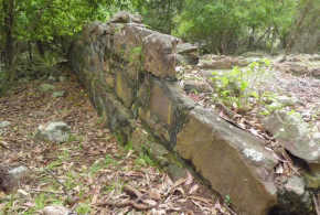
Text and Photos by Jones Matos da Silva

Bittangabee Bay is located in Ben Boyd National Park to the south of the coastal town of Eden along the south coast of New South Wales, Australia. These ruins are claimed by Kenneth McIntyre to be of Portuguese origin.

I drove there last month and took me 8 hours drive from Sydney (480 km), south towards Melbourne. It was not difficult to access the bay, it is well signed and even that the last 18 km to the bay are unsealed road the drive is quite pleasant.

These ruins are quite controversial, no one has really approach a conclusion of what they are, as a example, Gavin Menzies in his ‘1421’ consider it a Chinese construction.

I had seen ruins of Portuguese forts in Brazil and I can say that this is not a fort, but, the footprint reminding me of the old colonial houses in Brazil up to the 17th century, but sure, this is only a first impression.

According to Michael Pearson the ruins are not of Portuguese origin, in his studies he date back the ruins to the nineteenth century. Precisely the remains have been dated to 1844.

BIBLIOGRAPHY:

– Kenneth Gordon McIntyre “The Secret Discovery of Australia – Portuguese ventures 200 years before Captain Cook” Souvenir Press, 1977.

– Trickett, P. “Beyond Capricorn. How Portuguese adventurers discovered and mapped Australia and New Zealand 250 years before Captain Cook” 2007, East St. Publications. Adelaide

Categories
Dutch Colonialism Oceania

Australia and the Dutch East India Company (VOC)

Written by Peter Reynders

There have been a number of early European based ‘monopoly companies’ trading in Asia. The combined impact of the Portuguese Estado da India, the first practitioner of the monopoly product principle, the Muscovy, the Ostend, the Swedish and the English East India Companies, the VOC (Dutch East India Company) and the many smaller enterprises of the vast, old and highly developed intra-Asian trading network is often overstated. The few percentage points of the total Asian economic turnover that went to Europe and the number of European people living and trading in Asia compared to the Asian population was relatively insignificant in the two centuries of the VOC. None of the activities of these companies, however, is as significant as the role the VOC played in Australian’s early maritime history, because it was the VOC that made the Southland’s existence known to the world. It first placed our continent on the world map enabling better known mariners such as Dampier, Cook and Flinders to enter the story.

Of the 54 recorded European ships that sailed into Australian waters before 1770, 42 were VOC ships. “Sloepie” the first ship built here by Europeans, was built by a shipwrecked VOC crew. Our first European immigrants, Wouter Loos and Jan Pelgrom De Bye, convicted criminals, dropped off on the mainland in 1629, were VOC employees. The first armed conflict on land in our history between two groups of whites was between a VOC crew and its mutineers. The first recorded white ‘Southland baby’ was born aboard a VOC ship moored on our coast. The first recorded Europeans to chart part of our coast were Captain Willem Janszoon and his crew in Duyfken a small vessel bought second hand for ƒ 2200, heralding the beginning of our written history in 1606. The first recorded navigator to circumnavigate our continent and first prove that it is an island, and that it must have an east coast, lead the VOC’s exploratory forays. His name was Abel Tasman. The first pictures drawn by Europeans of our coast and of some of our wildlife were by artists aboard VOC ships.

That is not to suggest that the London based East India Company (EIC) has no connection with early Australian history. Our first European shipwreck, on the coast of Western Australia in 1622, the Tryall, was an EIC ship skippered by John Brookes. Like the Batavia, it too ended up as a horror story, but less heroic, less complicated, less well known.

With the exception of Captain Gonzal, who provided enthusiastic reports about this continent and its people, VOC captains invariably reported unfavourably on the trading potential with Aboriginal peoples. ‘Too poor to dress themselves’, ‘most miserable creatures on earth’ they would write in their logs. The VOC, having visited, sought trade, searched for their own shipwrecked vessels and tried to chart dangerous coastal features during the 17th century, did not deliberately return at all, apart from Gonzal in 1756, during the 18th century, arriving when they did only by accident.

Australians on the east coast know little about the VOC. In 2006 it was 400 years since it began our written history, in fact in early 1606 the Dutch explorer Willem Janszoon encountered and then charted the shores of Australia’s Cape York Peninsula. But many historians, researchers, educational bodies and media rely on Britsh sources in telling our story. Our national TV broadcasters usually focus on British history when it comes to our beginnings, often without even offering an Australian viewpoint. We watch Henry VIII and his wives, Elizabeth I, the Battle of Hastings, discuss the Magna Carta, as if they are relevant here, etc. but they hardly constitute our own early history. There are ABC programs on such things as the 400th anniversary of Guy Fawkes’ “Gunpowder Plot”, interesting but rather irrelevant to our history. In 1602, no Englishman, including Guy Fawkes, had ever heard of this Southland, other than perhaps as a legend. Yet in 2002 there was not a single program about the 400th anniversary of the founding of the VOC, the body that revealed Australia to the world.

BIBLIOGRAPHY:

– Godard, Philippe “First and Last Voyage of the Batavia” 332 pp.

– Playford, Phillip “Voyage of Discovery to Terra Australis” 113 pp. Willem de Vlamingh’s intrepid voyage to Australia 1696-1697

– Playford, Phillip “The Wreck of the Zuytdorp” 36 pp. West Australian Historical Society

– Playford, Phillip “Carpet of silver: the wreck of the Zuytdorp” xii, 260 pages, University of Western Australia Press, 1996-1998, Perth, Australia.

– Sigmond, J. P. and Zuiderbaan, L. H. “Dutch discoveries of Australia: shipwrecks, treasures and early voyages off the West Coast” 176 pp. ills. 1979 (1st English edition of the 1976 original Dutch title “Nederlanders Ontdekken Australie”), Adelaide, Australia.

– Tooley, Ronald Vere “Early maps of Australia The Dutch Period” 27 pp. 30 illus. Map Collectors’ Circle, 1965, London, UK. Examples from the collection of R.V. Tooley with bibliographical notes.

Categories
French Colonialism Oceania

Isle of Pines: Prison ruins and Cemetery of the Deported (Cemetery of the Communards) in New Caledonia

Written by Marco Ramerini. English text revision by Dietrich Köster.

Located south-east of Grande Terre (New Caledonia), the Isle of Pines is a small island full of natural wonders, endless white beaches and crystal clear water, caves and caverns, rich coral reef, natural wonders like the natural pool (piscine naturelle) with seawater, inhabited by a friendly population with rich traditions.

This enchanted island 14 km wide and 18 km long has a turbulent history. It was on this land of paradise that the protesters of the Paris Commune among other prisoners were exiled in the 19th century. Today the remains of the 19th-century buildings are touching witnesses to this period.

In 1872 the island became a French penal colony, home to 3,000 political deportees from the Paris Commune. The deportees were allocated to five different areas around the island, the most notable of which is that of Ouro. This is where you find the ruins of the penal colony, invaded by tropical vegetation. A little further upstream is the Cemetery of the Deportees (Cimetière des Déportés).

These places of sadness are just a few hundred metres away from the white sandy beaches of Kanumera and Kuto, two of the most fascinating places on the island.

[divider]

[divider]

Categories
French Colonialism Oceania

Fort Teremba: a prison for deportees in New Caledonia (Grande Terre)

Written by Marco Ramerini. English text revision by Dietrich Köster.

This fort is situated between La Foa and Bourail, 124 kilometers north of Nouméa.

In 1871 a group of 25 convicts, 2 wardens, 3 gendarmes and the head of the topographical department set up a camp on the left bank of La Foa river near the Kanak village of Uarai, later that year the camp was moved to a better site on the right bank of the river on a little hill.

This small camp was enlarged between 1871 and 1877 through the construction of several buildings: water tanks, cells, huts for military troops and for the convicts, the commander’s house, a chapel, some workshops and warehouses, a school, a bakery, an infirmary, a telegraph station, an anchorage etc..

The fort was built after the Kanak insurrection of 1878. Inside the perimeter of the walls were built a blockhouse, a watchtower and a prison. The number of the convicts was between 120 and 300, some of them worked at the farm penitentiary of Fonwhary, situated 8 kilometers away on a fertile and well irrigated land.

The settlement of Teremba was damaged by a cyclone in 1898.

In 1984 the Association Marguerite attempted to make Teremba a place of living memory. In 1989 the site was classified as historical monument. In 1992 the first buildings were restored. The site has actually a little museum and it is open Tuesday to Sunday from 9 AM to 4 PM, admission fee: 250 CFP.

Categories
Oceania Russian Colonialism

Russian presence in Hawaii. Russian forts and settlements in Hawaii

Written by Marco Ramerini. English text revision by Dietrich Köster.

In the early 19th century Russian fur traders established trading centers from Siberia into the North American subcontinent, Russian cargo vessels regularly transecting the northern Pacific Ocean. In January 1815 a Russian-American Company vessel, named “Bering”, that traded furs for food throughout the Hawaiian Islands, was shipwrecked at Waimea, Kauai. The ship and the cargo were confiscated by Kaumualii, king of Kauai. Subsequently the Russian-American Company sent an agent, Georg Anton Schäffer (a German surgeon of one of the Company’s vessels), to diplomatically recover the company’s lost properties.

Schäffer’s mission was to gain the confidence of Kamehameha I, who had acknowledged the right to sovereignty of Kaumalii in 1810. Once the bond existed between Schäffer and Kamehameha I, he was to reveal the true character of his mission and requested Kamehameha’s assistance in securing compensation from Kaumualii for the confiscated cargo. Despite opposition from a group of American traders, who had gained Kamehameha’s trust. By early 1816 Schäffer had been successful in obtaining fishing rights, livestock and a land grant to establish a post on Oahu.

Kamehameha I, however, did not lend the anticipated assistance. Georg Anton Schäffer tried an alternate plan: in May 1816 Schäffer went to Hawaii, and then to Kauai, dealing directly with Kaumualii. He was successful in securing a contract guaranteeing payment for his confiscated cargo.

On 1 July 1816 Schäffer also entered into a secret treaty with Kaumualii, in which he pledged arms and ships for an invasion of the islands of Oahu, Lanai, Maui and Molokai, which Kaumualii felt were his. In return Kaumualii promised one half of the island of Oahu and all the sandalwood on Oahu and Kauai to the Russians. They would also be permitted to build factories on all of Kaumualii’s newly conquered islands.

At Hanalei (Princeville) Schäffer opened a trading post and started the construction of a house. On 12 September 1816 Schäffer started the works of fortification of fort Elizabeth on a bluff overlooking the mouth of the Waimea River near Hanalei (Princeville). On October 1816 Schäffer constructed two earthwork forts, one named Fort Alexander in honor of the Tzar and the other known as Fort Barclay. Hanalei was renamed Schäfferthal.

Fort Elizabeth is the only Russian fort in Hawaii that is still visible today. It is situated on the east bank at the mouth of the Waimea River.It was built between 1816 and 1817 by the Russian-American Company in alliance with the king of Kauai, Kaumualii. Georg Anton Schäffer designed the fort and directed the works that were done by a Hawaiian workforce While construction proceeded, Schäffer received the message that his crew had been expelled from Oahu for building a fort and for raising a Russian flag on it. Alarmed by all these activities before the year was over, the natives of Hanalei had revolted, leveled the forts at Hanalei and burnt a distillery, which had just been built and killing one of the Aleutian workers employed by Schäffer.

On 8 May 1817 the Russians were expelled from Hawaii and the Hawaiians took over the fort. They finished the fort and made modifications and additions. The fort was occupied by Hawaiians until it was dismantled in 1864 by order of the Hawaiian government. The hexagonal star-like fort had walls reaching 3,66 metres in height and 91,44 metres in diameter and consisting of three layers: an earthen embankment, a layer of lava rock, and a hard-packed earth layer with a stone walkway atop. The compound included a guardroom, magazine, barracks, cannon emplacements and a trading post. Only the remains of the outer walls are left.

BIBLIOGRAPHY:

– Various Authors “Russian Fort Elizabeth, 1815-1864” State of Hawaii

– Pierce, Richard “Russia’s Hawaiian Adventure, 1815-1817” 1965

Categories
German Colonialism Oceania Spanish Colonialism

Micronesia (1565-1994), Forgotten Island World in the Pacific

Written by Dietrich Köster

German-Micronesia – also called “Island Territory” of German New Guinea – is the far-flung island world north of the equator in the Western Central Pacific and was up to 1914/1920 the northern part of German New Guinea, supplemented by the island of Nauru, lying just south of the equator. The land area is only slightly more than 2,500 sq. km. The population amounted to 62,000 in 1914 and now stands at 176,000. Altogether German-Micronesia consisted of the Mariana Islands excluding Guam, the Palau Islands, the Caroline Islands and the Marshall Islands with Nauru. There is a total of 2141 islands, of which only 98 are inhabited.

The Marianas, an island chain north of the island of Guam, had been colonized from 1565 to 1898 by Spain. Thus at the time of the purchase of these islands by the German Empire from Spain after the Spanish-American War the new German colonial authorities found a strong Spanish influence similar to the situation in Latin America. Incidentally, the Marianas were not administered directly from Spain for centuries but until the independence of Mexico were managed by this country. This was followed by an administration from Manila. The Mariana Islands lie on the way from Mexico to the Philippines. Here the Spanish galleons took aboard fresh provisions. With the loss of the Philippines in the above-mentioned war Spain was no longer interested in the Micronesian island possessions, selling them to the German Empire in 1899.

During the transfer of the Mariana Islands, the Imperial District Officer Georg Fritz in Garapan (on the island of Saipan) was appointed by the Governor of the Colony German New Guinea Rudolf Bennigsen. The District Officer provided active development from 1899 to 1907. Thus he founded a government school for indigenous children, holding classes himself until the arrival of the first teacher.

Already at the beginning of World War I Japanese naval forces occupied the islands. As there were no armed forces for German New Guinea, including the Mariana Islands, only a small police force, the Germans did not offer resistance to the Japanese.

The Island Territory of German New Guinea also included the Palau Islands. The flag-raising ceremony was performed from a German warship in 1885 but had to be annulled due to Spanish protests. The Spaniards claimed earlier rights of possession since the 16th century, but without having ever set foot on these islands. By arbitration of the Pope, Spain was to have retained these islands, but with the requirement to send administrative and military personnel to take over the islands effectively.

The same situation prevailed in 1885 on the island groups of Yap, Truk and Ponape, which form the Caroline Islands. Only now Spain was starting colonization here as well. Spanish Catholic priests took up their missionary work on the islands. The Spanish presence did not only come to an end on the Marianas and the Palau Islands in 1899. Following its defeat in the Spanish-American War and the loss of the Philippines, Spain also sold the Caroline Islands to the German Empire. In Yap Arno Senft took office as District Officer and in Ponape Dr. Albert Hahl took office in the same capacity. Palau and Truk each received a Station Officer.

In 1910/11 a revolt broke out over the question of providing a road construction labor force from among the locals of Ponape. After the assassination of the District Officer Gustav Böder four warships of the German East Asia Squadron, stationed in Tsingtao/German Kiautschou Territory, were ordered to Ponape. In a difficult guerrilla war ship crews could wrestle down the insurgents on the Dschokadsch Rock of the Sokehs Peninsula. The ringleaders were executed. Others involved in the uprising were exiled to the Palau Islands.
At the beginning of World War I the Palau and the Caroline Islands also suffered the fate of the Japanese conquest, the Germans not offering resistance.

The German takeover of the Marshall Islands east of the Caroline Islands took place in a different way. As Spain did not claim any property rights, the flag-raising by SMS Nautilus could be maintained in 1885. The main island area with Jabwor on the Jaluit Atoll became the seat of the German governor of the Colony of the Marshall Islands. In 1888 an inter-clan feud was settled by the Germans on the island of Nauru, located further to the south, which was declared part of the Marshall Islands administratively.

Until 1906 the private Jaluit Trading Company administered this archipelago on behalf of the German Empire as a chartered company. As Australia did not accept the trade monopoly of the Jaluit Company any longer, this company was not only deprived of its monopoly but also the sovereign rights over the Marshall Islands were revoked. Germany created an administration of its own now within the framework of German New Guinea by installing a District Officer in Jabwor and a Station Officer on Nauru Island. From 1906 the latter island experienced a dynamic boom. The discovery of rich phosphate deposits, which covered most of the island, was the basis for rapid economic development. With the outbreak of World War I an end was also put to the German activity here. As the Australian Navy arrived here prior to the Japanese one, the island was occupied by the Australians in 1914, whereas the Marshall Islands proper were seized by the Japanese.

The Versailles Peace Treaty, which came into force on 10 January 1920, stipulated that the Mariana Islands, the Palau Islands, the Caroline Islands and the Marshall Islands excluding Nauru, were entrusted to Japan as administering power under a C-mandate from the League of Nations as holder of sovereignty. An equivalent mandate administration for Nauru was established on the basis of this Treaty with Australia as administering power, also on behalf of Great Britain and New Zealand.

In the inter-war period the economy of the entire island area of Micronesia was quickly interpenetrated by the Japanese, with the exception of Nauru. Although the Marianas with their large sugar cane plantations and big sugar mills represented the focus of economic activity, the central headquarters of the Japanese South Seas area – called Nan-yo – became Koror in the Palau archipelago. Here a city was built from the ground, which was hardly different from a provincial city in Japan. The attempt of complete Japanization of Micronesia was typical for the years 1920-40. Thus the immigration of Japanese was heavily promoted officially, which made the local population a minority in their own island area. As from 1936 it was very difficult for a non-Japanese to travel to these islands. The Japanese started to fortify the mandated territory in the framework of their plans of conquering more islands of the Central Pacific. The Truk Islands were the seat of the headquarters of the Southern Command of their Navy.
After the Japanese raid on Pearl Harbor on 07 December 1941, the Japanese Fleet attacked many islands of the Western Central Pacific and occupied them, one of them being Nauru. This island was immediately fortified and the majority of the Nauruans was deported to Truk. In the course of the defeat of the Japanese in the Pacific during 1944-45 the entire Japanese mandated territory was conquered by U.S. troops. The Australians returned to Nauru in September 1945.

As the Japanese soldiers were known for their fanaticism – Kamikaze serving as an example – the Americans could conquer Nan-yo only with an utmost effort. Particularly fierce fighting took place in Truk, where the U.S. Air Force sank the major part of the Japanese Southern Command’s Fleet.
Heavy fighting developed around the islands Angaur, Peleliu and Koror in the Palau Islands. The fiercest battles occurred around Guam – an unincorporated U.S. territory – and on the Mariana Islands Rota, Tinian and Saipan. On Tinian, the former Japanese air base was hastily enlarged and used as a starting point for the dropping of atomic bombs on the Japanese cities Hiroshima and Nagasaki. On Saipan many Japanese soldiers were not ready to surrender. They plunged from a high rock, which is now called Suicide Cliff. The Japanese and Americans left behind extensive war material on this battlefield.

In 1947 the United Nations vested the trusteeship over Micronesia except Nauru in the United States of America as the United Nations Trust Territory of the Pacific Islands (TTPI). The U.S. Government succeeded in acquiring the status of a Strategic Area for this Trust Territory, the sea area of which encompasses 7.8 million sq. km, which equals the total land area of the United States. This was the justification for the USA to carry out various nuclear tests on the atolls of Bikini and Eniwetok of the Marshall Islands until 1958. These provoked numerous protests especially among the resettled Marshallese population. The USA also established a Ballistic Missile Test Site on the Kwajalein Atoll. As a result the Marshall Islanders became welfare recipients of the USA, due to the far-reaching loss of their subsistence agriculture. On Saipan – the main island of the Northern Marianas – many people are beneficiaries of food vouchers, known as Food Stamps, in spite of the recent establishment of textile mills and a thriving tourism industry, thanks to Japanese World War II veterans and honeymooners.

While the small United Nations Trust Territory of the island of Nauru became independent from Australia in 1968 as the Republic of Nauru, by repeal of the UN Trusteeship, and while this island still lives from the export earnings of the phosphate deposits, which are running short, the constitutional and economic future of the U.S.-administered UN Trust Territory of the Pacific Islands was not finalized for a long time.

The USA insist on deploying nuclear weapons on the Palau Islands. In 1979 the Constitution of Palau laid down that this island group is to be a nuclear-free zone. In a number of plebiscites the three-quarters majority required by the Constitution to repeal the provision on the nuclear-free zone had not been achieved. This prevented the ratification of the Association Agreement (Compact of Free Association) with the USA. This compact provides for a high degree of autonomy of the new Republic of Palau, also called Belau. The foreign and defense policy will continue, however, to be cared for by the USA.

On the other hand the Caroline Islands – now called the Federated States of Micronesia (FSM) – and the new Republic of the Marshall Islands (RMI) concluded Compacts of Free Association with the USA. Finally the constitutional status of the Northern Mariana Islands is fixed in such a way that the current status of a “Commonwealth of the Northern Mariana Islands in Political Union with the United States” may later be changed to a proclamation of the Northern Marianas as a 51st State of the USA.

As Palau hesitated to ratify its Compact of Free Association, the UN Trusteeship Council and the UN Security Council finally repealed the UN trusteeship system over the whole area of former German-Micronesia north of the equator – excluding the Palau Islands – on 22 December 1990.

Having overcome constitutional hurdles the Palau Islands ratified the Compact of Free Association with the United States after all. This was finally followed by the lifting of the UN trusteeship system for Palau – now Republic of Palau – on 01 October 1994 as well.

The Compacts of Free Association for the Republic of Palau, the Federated States of Micronesia (FSM) and the Republic of the Marshall Islands (RMI) provide for a strong financial support by the USA and a free access to the U.S. labor market.
In summary it can be said that the island groups of the UN Trust Territory of the Pacific Islands either will not become independent – this is the case of the Northern Mariana Islands – or are held in partial dependence of the United States with regard to foreign and defense policy by Compacts of Free Association. The latter applies to the Republic of Palau, the Federated States of Micronesia and the Republic of the Marshall Islands.

Copyright 2005 by Dietrich Köster, D-53115 Bonn

Categories
Dutch Bibliographies Dutch Colonialism Oceania

Oceania. Bibliography of Dutch Colonial History 17th-18th century

Written by Marco Ramerini. English text revision by Dietrich Köster.

DUTCH EMPIRE: OCEANIA

AUSTRALIA:

– Doolan, Paul, “First Europeans in Australia”, in: “History Today”, June 1999. – Godard, Philippe, “First and last Voyage of the Batavia”, 332 pp.

– Playford, Phillip, “Voyage of Discovery to Terra Australis”, 113 pp., Willem de Vlamingh’s intrepid voyage to Australia 1696-1697 (wanting)

– Playford, Phillip, “The Wreck of the Zuytdorp”, 36 pp., West Australian Historical Society.

– Playford, Phillip, “Carpet of silver: the wreck of the Zuytdorp”, xii, 260 pages, University of Western Australia Press, 1996-1998, Perth, Australia.

– Sigmond, J. P. and Zuiderbaan, L. H., “Dutch discoveries of Australia: shipwrecks, treasures and early voyages off the West Coast”, 176 pp., illustrations, 1979 (1st English edition of the 1976 original Dutch title “Nederlanders ontdekken Australië”), Adelaide, Australia.

– Tooley, Ronald Vere, “Early maps of Australia, The Dutch Period” 27 pp., 30 illustrations, Map Collectors’ Circle, 1965, London, United Kingdom. Examples from the collection of R.V. Tooley including bibliographical notes.

– Watt, Robin J., “A note on the two New Zealands”, Internet article.

– Walker-Birckhead, W., “Paying our way: private and public meanings of migration”, in: “The Australian Journal of Anthropology”, January 1998. An essay on Dutch emigration to Australia.

Categories
Asia Oceania Portuguese Bibliographies Portuguese Colonialism

Asia Far East: China, Japan, Australia. Bibliography of Portuguese Colonial History 16th-18th century

Written by Marco Ramerini. English text revision by Dietrich Köster.

PORTUGUESE EMPIRE: FAR EAST: CHINA, JAPAN

CHINA, JAPAN

– Barnett, Cherry “The last outpost”, in: “History Today”, December 1999

– Barreto, L. F. “O estatuto de Macau (séculos XVI-XVII)”, in: “Oceanos”, n°32, October/December 1997, pp. 133-148.

– Basto da Silva, Beatriz, “Fortalezas extramuros, baluartes e fortins”, in: “Revista Macau”, n° 81, January 1999, Macau.

– Basto da Silva, Beatriz, “As fortalezas da cidadela”, in: “Revista Macau”, n° 80, December 1998, Macau.

– Boxer, Ch. R., “The great ship from Amacon 1555-1650”, 361 pp., 2 maps, Instituto Cultural de Macao, 1988, Macau. The history of the Portuguese-Japanese relations and the annual Japan voyages, with several documents.

– Boxer, Ch. R. “Portuguese Merchants and Missionaries in feudal Japan 1543-1640” ?, illustrations, Variorum Reprints, 1986, London, United Kingdom.

– Boxer, Ch. R., “The Christian Century in Japan, 1549-1650” ?, 535 pp., University of California Press, 1967, Berkeley, USA.

– Boxer, Ch. R., “A Fidalgo in the Far East, 1708-1726: António de Albuquerque Coelho in Macao” ?, 410 ? pp., Far Eastern Quarterly, 1946, [Tokyo].

– Boxer, Ch. R., “Fidalgos in the Far East, 1550-1770. Fact and Fancy in the History of Macao” ?, xii, 298 pp., 16 plates, M. Nijhoff, 1948, Den Haag, The Netherlands. (2nd edition, London-Hong Kong: Oxford University Press, 1968; tradução portuguesa: “Fidalgos no Extremo Oriente, 1550-1770. Factos e Lendas de Macau Antigo”, Macau: Fundação Oriente-Museu e Centro de Estudos Marítimos de Macau, 1990).

– Boxer, Ch. R., “South China in the sixteenth Century: Being the Narratives of Galeote Pereira, Fr. Gaspar da Cruz, O.P., Fr. Martin” ?, 388 pp., 8 maps, 12 b.w. plates, Haklut Society, 1953, London, United Kingdom. This volume contains three narratives describing South China as it appeared to Portuguese and Spanish visitors in the years 1550-1575.

– Boxer, Ch. R., “A Portuguese embassy to Japan, 1644-1647” ?, 64 pp., Kegan Paul, 1928, London, United Kingdom. The author retraces Siqueira de Sousa’s voyage to Japan in 1644.

– Braga, J.M., “The Western pioneers and their discovery of Macao” ?, 1949, Macao. For early Portuguese relations with China before the foundation of Macao.

– Dias, Jorge, “A perspectiva portuguesa do Japão”, in: “Boletim do Centro de Estudos Marítimos de Macau”, pp. 103-110, N° 2, January 1989, Macau.

– Fok, K. C., “Early Ming images of the Portuguese”, in: “An Expanding World”, Vol. n° 4. Disney, A., ” Historiography of Europeans in Africa and Asia 1450-1800″, Ashgate Variorum, vol. n° 4, 1995; pp. 113-125, also in: “Aspects in History and Economic History, sixteenth and seventeenth century” 1987, Stuttgart pp. 143-155.

– Fok, Kai Cheong, “Estudos sobre a instalação dos portugueses em Macau” ?, 118 pp., Gradiva, 1996, Lisbon, Portugal.

– Kirishima, K. “Le Japon à la mode portugaise”, in: Critique, N° XLIV, pp. 648-657. Editions de Minuit/Centre National des Lettres, 1988, Paris, France.

– Larroche, H., “Macao, cité ambiguë”, in: Critique N° XLIV, pp. 640-647, Editions de Minuit/Centre National des Lettres, 1988, Paris, France.

– Ljungstedt, Anders, “A Historical Sketch of the Portuguese Settlements in China and of the Roman Catholic Church and Mission in China & Description of the City of Canton, 1836” ?, 280 pp., illustrations & maps, Viking Hong Kong Publications, reprint of the 1836 edition printed in Boston.

– Moisés Silva Fernandes, “Sinopse de Macau nas Relações Luso-Chinesas, 1945-1995” ?, Fundação Oriente, 2000, Lisbon.

– Moura, Francisco C., “Nagasaki, cidade portuguesa no Japão”, in: STUDIA N° 26, pp. 115 – 148, 1969, Lisbon, Portugal.

– Oliveira Marques (ed.), “História dos Portugueses no Extremo Oriente” ?, Lisbon —– , [s.n.], 1998.

– Prakash, Om, “Trade in a culturally hostile environment: Europeans in the Japan trade, 1550-1740”, in: “An Expanding World”, Vol. n° 10; Prakash, Om, “European commercial expansion in early modern Asia” pp. 117-128 Also in: “Clashes of culture: essays in honour of Niels Steensgaard”, Odense, 1992, pp. 245-254.

– Roderich Ptak, “Early Sino-Portuguese relations up to the Foundation of Macao”, in: Mare Liberum, Revista de História dos Mares Nº 4, 1992, Lisbon, Portugal.

– Santos Alves, Jorge dos, “From Malacca to Macau”, Revista Macau, 1997, Macau.

OCEANIA: AUSTRALIA

– Collingridge de Tourcey, George, “First Discovery of Australia and New Guinea: Being the Narrative of Portugese and Spanish Discoveries in the Australasian Regions, Between the Years 1492-1616, With Descriptions of their old Charts”, 136 pp., 34 illustrations and 24 maps, William Brooks & Co., (1895) 1906, Sydney, Australia.

– Fitzgerald, Lawrence, “Java La Grande: the Portugese Discovery of Australia ca. 1521”, xx + 140 pp., maps, The Publishers, 1986, Hobart, Australia.

– Mc Intyre K. G., “The Secret Discovery of Australia: Portuguese ventures 200 years before Captain Cook”, xxi – 427pp., maps, South Australia: Souvenir Press, 1977. This book deals with the author’s theory of Portuguese discovery of Australia.