Written by Marco Ramerini. English text revision by Dietrich Köster.
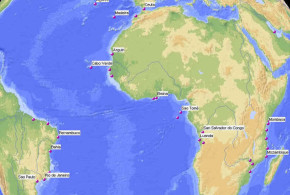
SPANISH AFRICA:
Ceuta:
Portuguese: 21 August 1415 – 1640
to Spain (after the Portuguese rebellion)
E. Sanceau “Castelos em África” Livraria Civilização 1961 Porto. D. Lopes “A Expansão em Marrocos” Teorema Lisboa
MOROCCO:
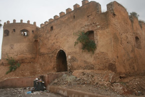
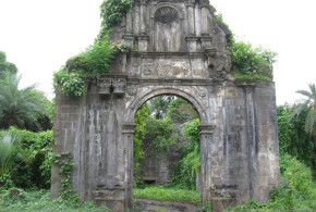
Alcacer Ceguer (El Qsar es Seghir): (35°51’N – 05°34’W)
Portuguese: 23 October 1458 – 1550
E. Sanceau “Castelos em África” Livraria Civilização 1961 Porto. D. Lopes “A Expansão em Marrocos” Teorema Lisboa
Arzila (Asilah): (35°28’N – 06°02’W)
Portuguese: 24 August 1471-August 1550
to Arabs (1550-1577)
Portuguese: 1577-1589
E. Sanceau “Castelos em África” Livraria Civilização 1961 Porto. D. Lopes “A Expansão em Marrocos” Teorema Lisboa
Tanger:
Portuguese: 27 August 1471 – 1661/62/63
to England (for the dowry of Catherine of Bragança)
E. Sanceau “Castelos em África” Livraria Civilização 1961 Porto. D. Lopes “A Expansão em Marrocos” Teorema Lisboa
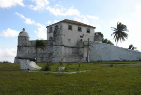
Safim (Safi): (32°18’N – 09°14’W) Castelo do Mar, Castelejo.
Portuguese: 1488 feitoria, 1508 fortress – Oct. 1541
E. Sanceau “Castelos em Africa” Liv. Civilizaçao 1961 Porto. D. Lopes “A Expansao em Marrocos” Teorema Lisboa
Graciosa (Graciosa Island near Larache): (35°12’N – 06°09’W) Fortaleza Graciosa
Portuguese: Feb. 1489 – Sep. 1489 (attempt to build a fortress, but later abandoned)
E. Sanceau “Castelos em África” Livraria Civilização 1961 Porto. D. Lopes “A Expansão em Marrocos” Teorema Lisboa
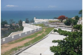
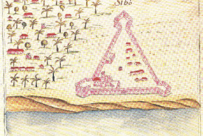
Santa Cruz do Cabo de Gué (Agadir-Taddert Ougadir): (30°27’N – 09°39’W) Fortaleza Santa Cruz do Cabo de Gué
Portuguese: 1505- 12 March 1541
E. Sanceau “Castelos em África” Livraria Civilização 1961 Porto. D. Lopes “A Expansão em Marrocos” Teorema Lisboa
Mogador (Essaouira): (31°31’N – 09°46’W) Castelo Real
Portuguese: 1506-1510
E. Sanceau “Castelos em África” Livraria Civilização 1961 Porto. D. Lopes “A Expansão em Marrocos” Teorema Lisboa
Aguz (Souira Guedima): (32°02’N – 09°21’W) Castelo de Aguz (South of Safi at the mouth of Tensift River)
Portuguese: 1506-1525
D. Lopes “A Expansão em Marrocos” Teorema Lisboa
Azamor (Azemmour): (33°18’N – 08°21’W)
Portuguese: 3 Sep. 1513 – Oct. 1541
E. Sanceau “Castelos em África” Livraria Civilização 1961 Porto. D. Lopes “A Expansão em Marrocos” Teorema Lisboa
Mazagão (El Jadida): (33°15’N – 08°31’W)
Portuguese: 1514, 1541 fort – 1769 abandoned
E. Sanceau “Castelos em África” Livraria Civilização 1961 Porto. D. Lopes “A Expansão em Marrocos” Teorema Lisboa
Mamora (Mehdiya ?): (34°15’N – 06°41’W)
Portuguese: June 1515- Aug. 1515 (unsuccessful attempt to build a fortress at the mouth of the rio Cebu, abandoned)
E. Sanceau “Castelos em África” Livraria Civilização 1961 Porto. D. Lopes “A Expansão em Marrocos” Teorema Lisboa
Seinal (near Alcacer Ceguer): (35°51’N – 05°34’W)
Portuguese: 4 Apr. 1549 – June 1550 (attempt to build a fortress on the mountain which dominated Alcacer, abandoned)
E. Sanceau “Castelos em África” Livraria Civilização 1961 Porto. D. Lopes “A Expansão em Marrocos” Teorema Lisboa
WESTERN SAHARA:
Rio de Ouro (Ad Dakhla ?): (23°33’N – 16°01’W)
Portuguese: 1440s. on a little island of this river the Infante D. Henrique “the Navigator” built a tower. The tower was perhaps built in one of the 3 islands at the entrance of Ad Dakhla (Angra dos Cavalos ).
Valentim Fernandes “Descripçam de Cepta por sua costa de Mauritania e Ethiopia……scripto no anno de 1507”
MAURITANIA:
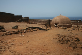
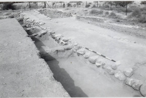
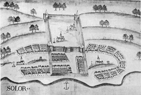
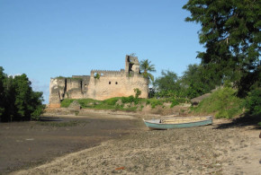
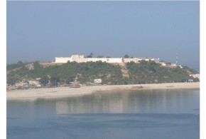
Arguim (Arguin island): (20°36’N – 16°27’W) Castelo de Arguim
Portuguese: 1445 feitoria, 1461 fort – 5 Feb. 1633
to the Netherlands
T. Monod “L’Ila d’Arguin: essai historique” IICT & CECA 1983 Lisboa.
Ouadan, Uadem, Audem or Wadan (Ouadane): (20°56′ N -11°37′ W)
Portuguese: circa 1487 feitoria
Maria E. Madeira Santos “Viagens de exploração terrestre dos portugueses em África”
SENEGAL-GAMBIA:
Portuguese: In 1488 or 1490, the Portuguese did an attempt to build a fort at the mouth of the Senegal River, this attempt ended in a failure.
Blake “European in West Africa 1450-1560” Maria E. Madeira Santos “Viagens de exploração terrestre dos portugueses em África”
Portuguese: In 16th. c. several settlements of Portuguese Lançados (mixed race) were founded along the Senegal shore in: Joal (14°11’N – 16°51’W), Portudal (14°26’N – 17°01’W), Rio Fresco, Beziguiche (Gambia ?), Cantor (Kuntaur (13°40’N – 14°53’W), Gambia) and Cassan (Gambia).
GUINEA BISSAU:
Porto da Cruz de Guinala: Forte da Cruz de Guinala
Portuguese: ? fort
Boulegue, J. “L’impact économique et politique des navigations portugaises sur les peuples côtiers. Le cas de la Guinée et du Cap Vert (XVème-XVIème siecles)” Almada, A. A. “Tratado breve dos rios da Guiné”
Bissau: Fortaleza de São José de Amura (1696)
Portuguese: 1696 – 1974
Bolama:
Portuguese: ? – 1974
Cacheu:
Portuguese: 1470 ? settlement, 1585/87/88 wooden fort – 1974
Boulegue, J. “L’impact économique et politique des navigations portugaises sur les peuples côtiers. Le cas de la Guinée et du Cap Vert (XVème-XVIème siecles)” Almada, A. A. “Tratado breve dos rios da Guiné”
Portuguese: In 16th. c. several settlements of Portuguese Lançados (mixed race) were founded along the Rio Cacheu (or Rio Farim) and Rio Geba (or Rio Grande).
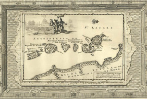
CAPE VERDE:
under construction
Santiago Island: Ribeira Grande, Praia
SIERRA LEONE:
Portuguese: Under João II (1481-1495), the Portuguese attempted to build a fort six leagues beyond Mellakory River in Sierra Leone on Rio Bitonbo. “Two leagues above the mouth of the Rio Bintonbo is a village called Tanguarim and three leagues farther up King João II had ordered to build a fortress. The King later ordered to pull the fortress down.”
Blake “Europeans in West Africa 1450-1560”
A. W. Lawrence “Trade castles and forts of West Africa”: abandoned within a few years.
Banana Islands, Sierra Leone: Banana Islands are an archipelago of Sierra Leone. These islands were first settled in the 17th Century by the Portuguese (source: “Lonely Planet Africa”).
Written By Zé Miguel Lopes
Port Loko, Sierra Leone: Port Loko is a town in Sierra Lone. It was established by the portuguese merchants. Later, the Temne people conquered the town.
Written By Zé Miguel Lopes
GUINEA:
Boké, Guinea (Conakri): Boke is a city in Guinea, near the Nunez River. In 1827 the Portuguese built a fort in this city. Later, it became a french possession. (source: http://www.voyage-guinee.fr/tag/boffa/).
Written By Zé Miguel Lopes
GHANA:
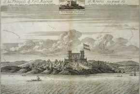
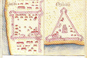
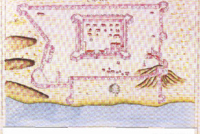
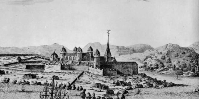
Castelo da Mina (Elmina): (05°05’N – 01°21’W) Fortaleza de São Jorge da Mina de Ouro (1482)
Portuguese: 21 Jan. 1482 – 28/9 Aug. 1637
to the Netherlands
A. W. Lawrence “Trade castles and forts of West Africa” Jonathan Cape 1963 London. Ch. R. Boxer “The Dutch in Brazil 1624-1657” Claredon Press 1957 Oxford. J. Vogt “Portuguese rule on the Gold Coast 1469-1682” Univ. of Georgia Press 1979 Athens.
Axim: (04°52’N – 02°15’W) Forte de Santo António de Axim (1503)
Portuguese: 1486 feitoria, 1503/1515 fort – Feb. 1642
to the Netherlands
A. W. Lawrence “Trade castles and forts of West Africa” Jonathan Cape 1963 London. Ch. R. Boxer “The Dutch in Brazil 1624-1657” Claredon Press 1957 Oxford. J. Vogt “Portuguese rule on the Gold Coast 1469-1682” Univ. of Georgia Press 1979 Athens.
Accra:
Portuguese: 1557- 1576/77/78 destroyed by the natives.
A. W. Lawrence “Trade castles and forts of West Africa” Jonathan Cape 1963 London. J. Vogt “Portuguese rule on the Gold Coast 1469-1682” Univ. of Georgia Press 1979 Athens.
Chama (Shama): (05°00’N – 01°39’W) Forte de São Sebastião or San Sebastian
Portuguese: 1526*/1555 lodge, 1558 fortified house – 1637 **
to the Netherlands
A. W. Lawrence “Trade castles and forts of West Africa” J. Vogt “Portuguese rule on the Gold Coast 1469-1682”
* Ephson “Ancient forts and castles of the Gold Coast (Ghana)”: give the date 1526 for the first lodge.
** Goslinga “The Dutch in the Caribbean and in the Guianas 1680 – 1791” p.46: give the date 1640
Duma (Egwira): (05°02’N – 02°12’W) (at the confluence of Ankobra and Duma rivers)
Portuguese: Forte Duma 1623 fort – 1636 abandoned after an earthquake
van Dantzig “Les Hollandais sur la Côte de Guinée a l’ époque de l’essor de l’Ashanti et du Dahomey 1680-1740” Claridge “History of the Gold Coast and Ashanti” Ephson, I. S. “Ancient forts and castles of the Gold Coast (Ghana)”
Portuguese: The ruins of this fort were seen in 1653 by a Dutch expedition. (A.R.A. Aanwisten 1898, Journal de Louis Dammaerts).
Accra-Osu, Christiansborg: Forte de São Francisco Xavier
Portuguese: In 1640 the Portuguese built a lodge in Accra called Ursu lodge, this lodge was lost in 1645.
Ephson, I. S. “Ancient forts and castles of the Gold Coast (Ghana)”
The Danish built a fort (1661- Dec. 1680)
Portuguese: Dec. 1680 – 29 Aug. 1682 abandoned
A. W. Lawrence “Trade castles and forts of West Africa” Jonathan Cape 1963 London. J. Vogt “Portuguese rule on the Gold Coast 1469-1682” Univ. of Georgia Press 1979 Athens.
BENIN:
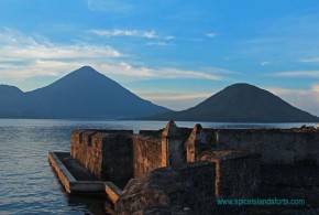
Ajudá (Glehoué, Ouidah or Whydah): (06°21’N – 02°05’E) Forte São João Baptista de Ajudá
Portuguese: 1721/22 fort -1 Aug. 1961
van Dantzig “Les Hollandais sur la Côte de Guinée à l’ époque de l’essor de l’Ashanti et du Dahomey 1680-1740”
Jaquin (Godomey): (06°23’N – 02°21’E)
Portuguese: feitoria
van Dantzig “Les Hollandais sur la Côte de Guinée à l’ époque de l’essor de l’Ashanti et du Dahomey 1680-1740”
NIGERIA:
Gwato (near Benin city): along Benin River.
Portuguese: 1485/86 feitoria – 1507/8/1520s.
Maria E. Madeira Santos “Viagens de exploração terrestre dos portugueses em África” Blake “European in West Africa 1450-1560” A. W. Lawrence “Trade castles and forts of West Africa”
EQUATORIAL GUINEA:
Ano Bom (Annobon or Pagalu island):
Portuguese: ? – Oct. 1641
to the Netherlands
to Portugal
to Spain 11 Mar. 1778 Tratado do Pardo: cedencia das ilhas de Fernando Pó e Ano Bom à Espanha.
Ayene (Guinea Ecuatorial): (01°06’N – 09°44’E)
Portuguese: fort ?
Fernando Pó (Bioko island):
Portuguese: fort (forte português )
Cunha Matos “Corografia Histórica das Ilhas de São Tomé e Príncipe , Ano Bom e Fernando Pó” São Tomé, 1916; p. 93
to Spain (Dec. 1779 – 30 Oct. 1780) abandoned
to Spain 11 Mar. 1778 Tratado do Pardo: cedência das ilhas de Fernando Po e Ano Bom à Espanha.
SÃO TOMÉ AND PRÍNCIPE :
São Tomé island: Forte de São Sebastiao, Forte São João, Forte de São Jerónimo.
Portuguese: 1485 first colonization – 1567
sacked by French pirates (1567)
Portuguese: 1567 – 18 Oct. 1599
to the Netherlands (18 Oct. 1599 – Nov. 1599)
Portuguese: 20 Oct. 1599 – 3 Oct. 1641 the Dutch occupied the town (16 Oct. 1641 the Dutch occupied the fort)
to the Netherlands (3 Oct. 1641 the Dutch occupied the town, 16 Oct. 1641 the Dutch occupied the fort – 13 November 1642 the Portuguese took the town (15 December 1644 the Portuguese took the fort)
* During the period between 1644 – 9 January 1649 the Dutch had a factory in São Tomé.
Portuguese: On 13 November 1642 the Portuguese took the town (15 December 1644 the Portuguese took the fort) – 1974
Garfield “A history of São Tomé Island 1470 – 1655, the key to Guinea”
Príncipe island: Fortaleza de Santo António da Ponta da Mina (1695 ?), Reducto Nossa Sennhora da Nazareth, Bateria de São Joao, Fortaleza de Santa Ana.
to Portugal
to the Netherlands (August 1598 – October 1598)
to Portugal
to France (1706 – ? )
Portuguese: ? – 1974
Pereira de Melo “A Fortaleza da Santo Antonio da Ponta da Mina na Ilha do Príncipe “
ANGOLA:
São Salvador do Congo (M’banza Congo): (6°16’S – 14°15’E)
Portuguese: since 1500s. Portuguese protectorate.
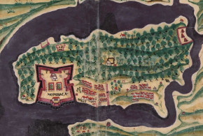
São Paulo de Luanda or Loanda (Luanda): (08°49’S – 13°14’E) Fortaleza de São Miguel or do Morro (Dutch: Fort Aardenburgh), Forte Guia, Fortaleza São Pedro da Barra (17th c.), Forte Santo Antonio, Forte São Francisco do Penedo (17th c.).
Portuguese: 20 February 1575- 26 Aug. 1641
to the Netherlands (26 Aug. 1641- 21/24 Aug. 1648)
Portuguese: 21/24 Aug. 1648 – 1974
Boxer “Salvador de Sá and the struggle for Brazil and Angola 1602-1686”
Benguela a Velha:
Portuguese: 1587 abandoned
Maria E. Madeira Santos “Viagens de exploração terrestre dos portugueses em África” Studia N° 33 “O regimento do fundador de Benguela…”
Massangano: (09°38’S – 14°14’E)
Portuguese: 1583 – 1974
Randles “L’ancien Royaume du Congo” Maria E. Madeira Santos “Viagens de exploração terrestre dos portugueses em África”
Muxima: (09°32S – 13°57’E)
Portuguese: 1599 – 1974
Randles “L’ancien Royaume du Congo”
Cambanbe or Kambambe: (9°46’S 14°39’E) along the Cuanza river, East of Dondo (Province of Kwanza Norte)
Portuguese: 1604 – 1974
Randles “L’ancien Royaume du Congo”
Ambaca (N’Dalatando ?): (09°18’S – 14°55’E) ?
Portuguese: 1611 – 1974
Randles “L’ancien Royaume du Congo”
São Filipe de Benguela: (15°35’S – 13°24’E) Fortaleza de São Filipe de Benguela
Portuguese: 1617 fortaleza de São Filipe – Sep. 1641
to the Netherlands (Sept. 1641-1648)
Portuguese: 1648 – 1974
Maria E. Madeira Santos “Viagens de exploração terrestre dos portugueses em África” Studia N° 33 “O regimento do fundador de Benguela…”
Ambuila (Uige): (07°37’S – 15°03’E)
Portuguese: 1625/1649/1681 market
Randles “L’ancien Royaume du Congo”
Beja: (09°47’S – 15°12’E)
Portuguese: 1625 market
Randles “L’ancien Royaume du Congo”
Dondo: (09°42’S – 14°26’E)
Portuguese: 1625 market
Randles “L’ancien Royaume du Congo”
Aco (Haco): (10°10’S – 15°42’E)
Portuguese: 1627 market
Randles “L’ancien Royaume du Congo”
Pungo Andongo: (09°39’S – 15°36’E) Fortaleza das Pedras de Pungo Andongo
Portuguese: 1627 market, 1671 fort – 1974
Randles “L’ancien Royaume du Congo”
Pinda: (06°12’S – 12°24’E) (at the mouth of the Congo River)
Portuguese: ?fort?
to the Netherlands ( – 1648)
to Portugal
(in accordance with a manuscript of the Torre de Tombo, Lisbon, n° 1006 quoted in Welch “Portuguese and Dutch in South Africa” p.36)
Ensandeira island: (09°20S – 13°10’E) (at the mouth of the Kwanza)
Portuguese: 1645 fort – 1645/46
to the Netherlands (1645/6-1648) renamed Fort Mols
Portuguese: 1648 – ?
Welch “Portuguese and Dutch in South Africa” p.23 Boxer “Salvador de Sá and the struggle for Brazil and Angola 1602-1686”
São José de Encoge (Encoje): (07°39’S – 14°41’E) Forte São José de Encoge (1759)
Portuguese: 1759 – 1974
Randles “L’ancien Royaume du Congo”
Caconda: (13°44’S – 15°04 E)
Portuguese: fort ?
Maria E. Madeira Santos “Viagens de exploração terrestre dos portugueses em África”
Alva Nova (Sá da Bandeira, Lubango): (14°55’S – 13°29’E)
Portuguese: 1769 settlement – ?
Maria E. Madeira Santos “Viagens de exploração terrestre dos portugueses em África”
Sarzedas (Luceque): (14°39’S – 15°04’E) ?
Portuguese: 1769 settlement – ?
Maria E. Madeira Santos “Viagens de exploração terrestre dos portugueses em África”
Cacanje or Cassange: (09°55’S – 18°17E) ?
Portuguese: 1770s. settlement – ?
Maria E. Madeira Santos “Viagens de exploração terrestre dos portugueses em África”
Quilengues: (14°05’S – 14°05’E)
Portuguese: 1770s. settlement – ?
Maria E. Madeira Santos “Viagens de exploração terrestre dos portugueses em África”
Cabinda: (05°33’S – 12°11’E)
Portuguese: 1783 – June 1784 (attempt to build a fort)
Portuguese: 1786 – 1974
Quicombo: (11°19’S – 13°49E)
Portuguese: Fort ?
NAMIBIA
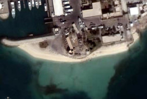
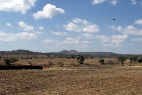
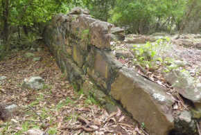
Fort Mocusso, Namíbia: Fort Mocusso is a portuguese fort near Andara, in Namibia, near the border with Angola. It was built in 1909 and abandoned in january 1912.
Written by Zé Miguel Lopes