This post is also available in:
![]() Português
Português
Written by Marco Ramerini. English text revision by Dietrich Köster.
Continued from: The first contacts with the Portuguese
3.0 THE ARRIVAL OF THE DANES, THE DUTCH AND THE CONSTRUCTION OF THE PORTUGUESE FORT
The strategic importance of the control over the bays and the ports on the eastern coast of Ceylon discovered, it was clear with the arrival of the first European contenders on the Asian seas, that in fact the first contact between the Dutch and the king of Kandy had taken place in 1602 in the region of Batticaloa. In June 1602 the Dutch admiral Joris van Spilbergen disembarked in the vicinities of Batticaloa and from here he proceeded towards Kandy, in the attempt to stipulate an alliance against the Portuguese. Spilbergen succeeded in obtaining protection and he was granted trade privileges for Dutch merchants, and in September of the same year he left again. Three months after the departure of Spilbergen, another Dutch expedition arrived in Batticaloa. It was under the command of vice-admiral Sebald de Weert. He was initially received with great enthusiasm by the King of Kandy Vimala Dharma Suriya I, but then on his second visit to the king, things went bad because of his behaviour and de Weert was killed. The eastern coast and in particular Batticaloa were during those years the preferred places of disembarkation of the Dutch flotillas at the try of contacts with the reign of Kandy.
But the first Europeans to attempt a first settlement in Trincomalee, were neither the Portuguese nor the Dutch, but the Danes. They arrived at Ceylon on the end of 1619 with a first ship, called “Øresund” under the command of Roelant Crape. This small expedition was the vanguard of another Danish fleet, this one composed of four vessels and three hundred soldiers, commanded by Ove Giedde, which reached the island in May 1620. Such an expedition had been equipped by the Danish East India Company1 by following the example of the Dutch East India Company (VOC), thus wanting to make a fortune in the Asian seas.
The Danish expedition occupied the temple of Trincomalee, and it was here where the Danes began the works for the fortification of the peninsula. Initially the king of Kandy, Senarat, was much colder in comparison with the Danish. He had, in fact, only a few years ago (in August 1617) concluded a peace treaty with the Portuguese and he noticed that the small Danish expedition, would never be able to destroy the Portuguese power on the island. Initially he suggested to the Danes to form an alliance with Mayadunne 2, who was still at war with the Portuguese, but later on he agreed to sign an alliance with the Danish company and on 21 August 1620 a treaty of alliance was signed between the Danes and king Senerat in an anti-Portuguese objective. Senarat sent to Trincomalee 60 men in order to help the Danes in the construction of their fort. During their stay in Trincomalee the Danish also coined some “Larins”, on which were recorded the words ‘Dom Erich Grubbe’. Today there is no trace left of these coins, except in the diary of Ove Giedde.3 Queyroz informs us also about this Danish expedition: he narrates that 5 large Danish ships were in the port of Trincomalee where they were building, with the aid of the Singhalese, a fortified place. The Portuguese had well noticed this new intrusion in the affairs of the island and readily reacted: the Captain General marched through Trincomalee and sent the captains Cabral and Barreto to Kottiyar, where one of the enemy ships was berthed. The Danes were forced to a hasty escape, in which they lost two ships and some men.4 Subsequently, the Danes, decimated from diseases, abandoned the enterprise in 162.
After this Danish attempt the Portuguese became aware of the urgency to establish at least a fortified base on the eastern coast of Ceylon, in order to be better able to control the traffic of goods along the coast and in order to hold under tighter control the kingdom of Kandy. The Portuguese believed mistakingly, that the Danish had been asked by king Senarat not to respect the peace treaty, which he had signed in August 1617. In the meantime the Portuguese crown had already sent new orders for the fortification of Trincomalee and Batticaloa in 1619 and later in 1620. But this meant to break the peace treaty and to reopen the conflict with Kandy. The news of the Danish expedition did not make other sense than assuring the Portuguese of the necessity to occupy the ports of the eastern coast.
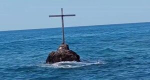
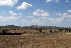
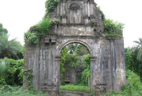
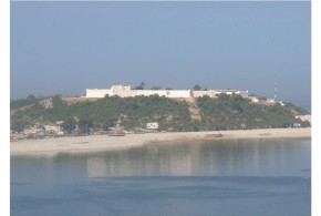
In 1623 Constantino de Sá e Noronha arrived in Ceylon for a second time as Captain General, and at this occasion he had received specified orders from the Viceroy Dom Francisco da Gama to proceed with the fortification of Trincomalee. 5 He did not lose time and in July 1623, reached Trincomalee, resolute to fortify the bay in order to stop the commerce, which the king of Kandy entertained through Muslim merchants with the other Asian kingdoms. Moreover there was still a more important reason: Preventing other European nations to use Trincomalee as a base for the conquest of the island.6 The place, which was chosen for the construction of the fort was situated where the temple of Konesar (Koneswaram) was and had already been installed by the Danish during their short occupation. This time the temple was destroyed, and its stones were used for the construction of the Portuguese fort. During the destruction of the temple a stone slab, in ancient Singhalese, was found by the Portuguese, in which was foretold the destruction of the temple by a part of the people called “Francos“, with whom the Portuguese identified themselves. According to the inscription the temple would not have been reconstructed. This stone was placed at the entrance of the Portuguese fort.7 The king of Portugal, informed of the construction of the fort, complimented Constantino de Sá e Noronha and ordered, in spite of the contrary opinion of the latter, the construction of a fort in Batticaloa, too. Moreover the king suggested the transfer of a part of the Christians of the coast ‘da Pescaria’ to Ceylon (Trincomalee) to populate the island.8
Constantino de Sá left a garrison of 80 Portuguese and 100 Lascarins behind9 under the command of Francisco Pinto Pimenta10, with the aim to finish the works of the fort and to extend the Portuguese influence in the neighbouring villages, thus securing provisions and men for the work. Initially 14 pieces of artillery were mounted in the fort, which were taken with great difficulty from the shipwrecked Danish ships.11 The Portuguese put under their direct control several surrounding villages (Tambalagama, Gantale etc.), on which they imposed a tribute: the villages had to supply to the captain of the fort rice and elephants.12 As reprisal the king of Kandy organized various expeditions against these villages to prevent every kind of aid to the Portuguese.13 The successive year (1624)14 the Portuguese were forced to organize a new expedition and once again Constantino de Sá arrived in Trincomalee. This time he finished the works for the construction of the fort. At that occasion a community of 30 Casados, coming from Goa, was also settled.
The construction of the fort and the destruction of the temple at the same time considerably complicated the relationship with Senerat, the king of Kandy. He felt besieged: the best ports of the island were in Portuguese hands and the kingdom of Kandy risked to become dependent on the Portuguese for every trading activity and for every contact with the outside world. It seems that an important role in trying to calm the reaction of the king to the occupation of Trincomalee has been played by the Franciscan friar Eleutério de Santiago. He was sent to Kandy by Constantino de Sá just for this purpose. 15
Queyroz strongly criticized the occupation of Trincomalee. He in fact judged it an error to close Kandy in the forthcoming time and nearly to force it to form an alliance with other European powers. Moreover seen the scarcity of troops and means it was suicide to disperse the troops in so many small fortifications. Moreover the aim to close the commerce of the reign of Kandy was not easy to carry out, unless the Portuguese were able to be the masters of the whole island. The same function of control exercised over the Kandyan commerce from the fort of Trincomalee could be easily carried out from boats, leaving from the ports of Galle and Jaffna and patroling the coast and this without offending the Kandyans and at minor cost for the finances of the ‘Estado da Índia’.16 In 1627 the viceroy Dom Francisco da Gama judged the construction of a new fortress in Batticaloa as useless. He voiced his opinion that 6 boats were enough to guarantee the security of the entire eastern coast.17
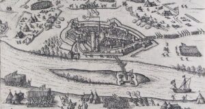
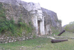
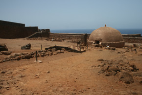
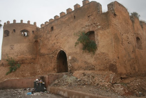
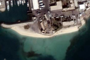
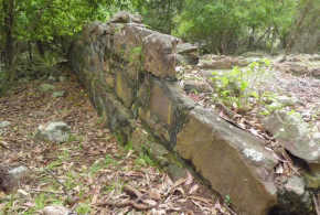
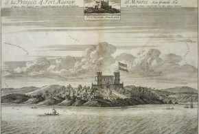
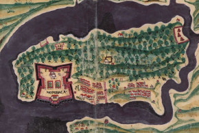
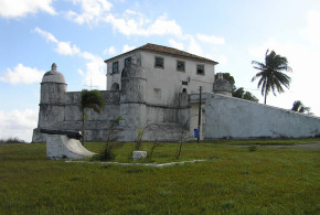
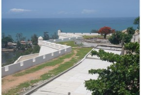
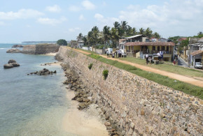
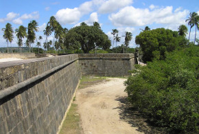
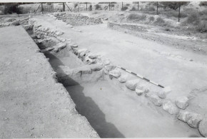
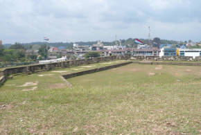
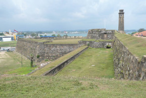
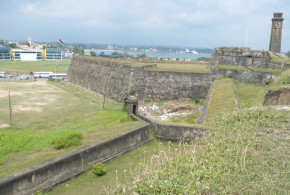
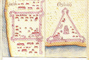
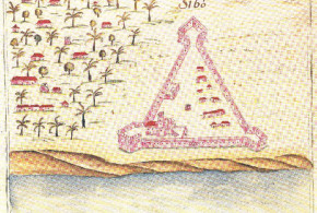
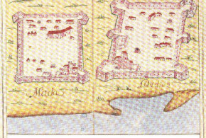
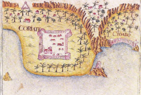
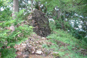
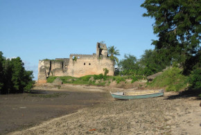
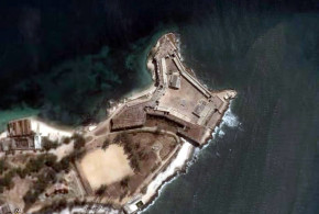
The fort, built “of stone and mortar” by the Portuguese, was of triangular shape. With three bastions to the three angles, the more important bastion was called ‘Santa Cruz‘. It was the key for the defence of the bay and situated on the south side of the isthmus, thus having direct access to the water of the bay. On this bastion were mounted six pieces of artillery. On the north end of the isthmus there was the bastion of ‘Santo António’ to be found. It was equipped with five pieces of artillery. The two main bastions were connected by a wall 100 “paços” long, three and half “braças” high and six “palmos” thick. This wall closed the isthmus on its narrowest part. A third bastion, the smallest of the three, was situated on the north side up on the peninsula. On this bastion three pieces of artillery were mounted. All the artillery has been recovered together with the remains of a Danish ship. Another wall of the same dimension of the previous one, connected on the south side this third bastion with the main bastion of ‘Santa Cruz’. While on the north side the third bastion was connected with that of Santo António only by a parapet of “pedra and cal” situated on the top of the rock cliff to the sea, the Portuguese had modified the escarpment below this wall to render it steeper. On the higher end of the peninsula a small settlement of Portuguese ‘casados’ and indigenous people was situated: in total ‘vinte brancos e vinte e cinco pretos’. The casados together with 50 Portuguese soldiers guaranteed the garrisoning of the fortress. The soldiers resided inside of the fortress together with their captain, while the captain of the fort named by the King or by the Viceroy, resided in a house in the settlement of the casados.18 In accordance with a map in the “Livro das plantas, das fortalezas, cidades e povoações do Estado da Índia Oriental” another isolated bastion existed on the south side of the rocky promontory. In front of the two main bastions a ditch seemed to have existed. A small native village was situated between the Portuguese fort and the bay. In the Bocarro’s map are also shown three temples on the extreme end of the peninsula. On the other hand temples did not exist on the map of the “Livro das plantas, das fortalezas, cidades and povoações do Estado da Índia Oriental” in the library of the Paço Ducal de Vila Viçosa. The entrance of the fort seems to have been situated along the southern wall on the side of the village of the ‘casados’.
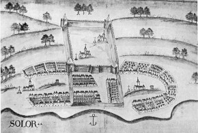
Another interesting map of the Portuguese age, compiled by the same Constantino de Sá, governor of Ceylon, shows the fort of Trincomalee situated on the isthmus of the peninsula, clearly indicated on it the village of the casados, called “pouvasam“, situated on the peninsula beyond the fort, the same fort was of triangular shape with three bastions. It is a part of the same collection, a greater map of the fort, entitled “Planta da fortalesa de Trinquilimale” indicating the names of the three bastions: S. Cruz (the larger bastion), S. António and the small S. Tiago, with the indication “este baluarte se acomodou ao sítio“. On the inner side of the fort the name of N. S. de Guadalupe is to be found, indicating the name of the church of Trincomalee. Constantino de Sá informs us that on the three bastions 16 pieces of artillery were mounted and the garrison comprised 40 soldiers and 30 casados. The place was judged by de Sá as impregnable, being placed on high cliffs and, according to his opinion, this Portuguese city with several works of fortification could be considered as one of the strongest places of the entire East.19 This is the description, which captain João Ribeiro gives us of the fort of Trincomalee: the fort was a triangular fortress with three bastions, one on each angle, armed with 10 iron guns, it was constructed on a hill near the ‘Baia dos Arcos’, inside the fort was a church 20 and a warehouse for the goods and ammunitions. A captain and 50 soldiers formed the garrison, in the fortress resided a constable, 16 Casados and a chaplain.
21 The dimensions of smaller sides of the fortress were 75 meters, the greater side measured 150 meters.
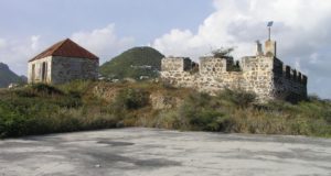
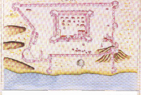
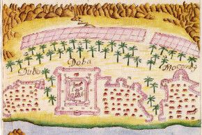
In 1628, after the continuous insistences by the King of Portugal and against the opinion of the viceroy and the governor of Ceylon, to prevent a feared occupation by the Dutch, the Portuguese occupied also Batticaloa and constructed there a fort. It was the same Constantino de Sá e Noronha who commanded the expedition who built the fort of Batticaloa. He reached with three boats Trincomalee in March 1628, where he reinforced the garrison, then he marched to Batticaloa with 100 Portuguese and 2000 lascarins. He chose for the site of the fort an island of the lagoon.22 In July 1628 the construction of the fort was entrusted to Damião Botado and it was called “Forte da Nossa Senhora
da Penha de França“. The small fort was constructed on an island, which protected the bay, and where the boats could only enter with high tide, the island was and is still called island of Puliyantivu. The fort was of square shape, with four bastions armed by 12 iron guns and on the inner side was a church and a warehouse for the goods and ammunitions. It had a garrison of 40 – 50 soldiers, a captain, a constable, a chaplain and 20 casados. The chosen place for the construction of the fort of Batticaloa, had various weak points, in fact it lacked a supplying source of water inside of the walls, the channel that separated the island from the mainland was too shallow and too narrow and it did not prevent the passage of troops in case of attack. Finally the access to the sea was difficult and it was more than three miles from the fort. A few years after its construction it was proposed to rebuild the fort on a better place, but the chronic lack of funds from Goa, prevented this achievement.
The king of Kandy, Senerat, as reprisal for the construction of the fort of Batticaloa, stopped every land connection with the forts of Batticaloa and Trincomalee, the Portuguese garrisons succeeding in surviving thanks to the aids that reached them by sea from Jaffna. Just as during the whole history of Ceylon the control of the seas was a decisive advantage, which Europeans (Portuguese, Dutch and finally the British) always possessed compared with the Singhalese. This circumstance allowed them to dominate uninterruptedly the coastal areas of the island for approximately 450 years.
After their construction, the two Portuguese forts of the eastern coast, Trincomalee and Batticaloa, were put under the jurisdiction of the captain of Jaffna.23 Normally, in each of the forts of Trincomalee and Batticaloa a Jesuit father resided.24 It seems that the first result of conversion in the area of Trincomalee had been encouraging. In fact father Rebelo, head of the mission of Jaffna, already wrote in November 1625 that in the preceding year the Jesuit father in the fort of Trincomalee had converted 11,000 souls.25
To be continued by: The Dutch conquest and the abandonment of the Fort
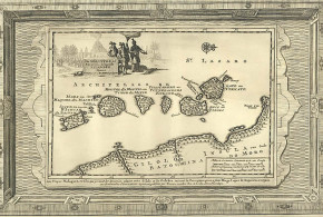
Sri Lanka (Ceylon) Map (1681). Robert Knox. An Historical Relation of the Island Ceylon.
NOTES:
1 The Danish company was founded on 17 March 1616.
2 Mayadunne was forced after having hardly been defeated by the Portuguese to shelter, on 2 July 1620, on a berthed Danish ship in the port of Kottiyar.
3 Barner Jensen, U. “Danish East India. Trade coins and the coins of Tranquebar, 1620-1845”, pp. 11-12; Holden Furber “Imperi rivali nei mercati d’oriente, 1600-1800”, note n° 66, p. 326.
4 Queyroz “The temporal and spiritual…”, vol. II, p. 727.
5 Queyroz “The temporal and spiritual…” vol. II, p. 734.
6 de Silva “The Portuguese in Ceylon, 1617-1638”, p. 67, 69 note n° 33.
7 Queyroz “The temporal and spiritual…”, vol. I, pp. 66-67.
8 Various Authors “Documentos remetidos da Índia ou Livros das Monçỡes, 1625-1627”, CNCDP, 1999, Lisbon, pp. 34-35, doc. n° 66 (Lisboa, 13 de Fevereiro de 1625), p. 203, doc. n° 635 (Lisboa, 4 de Abril de 1626).
9 Queyroz “The temporal and spiritual…”, vol. II, p. 737.
10 Subsequently he was replaced, for familiar reasons (the death of his father-in-law, who had left a young daughter), by Diogo Vaz Freire. Various Authors “Documentos remetidos da Índia ou Livros das Monçỡes, 1625-1627”, p. 102 doc. n° 283 (Goa, 23 Janeiro 1625), p. 184 doc. n° 595 (Goa, 23 de Fevereiro de 1626).
11 Queyroz “The temporal and spiritual…”, vol. II, p. 737.
12 Queyroz indicates us that the lands near Trincomalee were most fertile, with abundant rice production. Queyroz “The temporal and spiritual…” vol. I pp. 68-69
13 After the Portuguese occupation of Trincomalee many farmers of the villages of Tambalagama and Gantale moved to Kottiyar. Queyroz “The temporal and spiritual…”, vol. I, p. 69.
14 Summer 1624 says Queyroz. Queyroz “The temporal and spiritual…”, vol. II, p. 736.
15 Queyroz “The temporal and spiritual…”, vol. II, p. 698; Perniola, V. “The Catholic Church in Sri Lanka. The Portuguese period”, vol. II, pp. 352-353; Trindade “Conquista espiritual do Oriente”, vol. III, pp.79-80.
16 Queyroz “The temporal and spiritual…”, vol. II, p. 735.
17 Various Authors “Documentos remetidos da Índia ou Livros das Monçỡes, 1625-1627”, p. 331 doc. n° 880 (Goa, 20 de Fevereiro de 1627).
18 Bocarro, A. “Livro das plantas das fortalezas cidades e povoações do Estado da Índia Oriental”, p. 238.
19 “Costantine de Sa’s maps and plans of Ceylon”, p. 57.
20 Called in Caen’s diary “Nossa Senhora de Garde Rope” that is “Nossa Senhora de Guadalupe”, in: J.R.A.S. (Ceylon), n°35 (1887) “The capture of Trincomalee A.D. 1639”, p. 138.
21 Ribeiro “The historic tragedy of the island of Ceilão”, p. 36.
22 de Silva “The Portuguese in Ceylon, 1617-1638”, p. 89.
23 Queyroz “The temporal and spiritual…”, vol. II, pp. 757-758.
24 In the year 1628 in Trincomalee the father Sebastião de Fonseca was present, while in Batticaloa resided father António Soeiro. In 1634 was present in Trincomalee father João Moura, while the father Melchior Grasão preached in the fort of Batticaloa. Perniola, V. “The Catholic Church in Sri Lanka. The Portuguese period”, vol. III, pp. 125-126, 217 and 242.
25 Perniola, V. “The Catholic Church in Sri Lanka. The Portuguese period”, vol. III, p. 84.
This post is also available in:
![]() Português
Português