Written by Marco Ramerini. English text revision by Dietrich Köster.
DUTCH EMPIRE: ASIA
ASIA GENERAL:
– Various Authors, “All of one company, the VOC in biographical perspective”, 230 pp., HES Uitgevers, 1986, Utrecht, The Netherlands. Index: Testament to a Towkay: Jan Con Batavia and the Dutch China trade, the voyage of the Dutch merchant Pieter van den Broecke to the court of Dja’far Basha in Sana’a 1616, the hidden life of Samuel van de Putte (1690-1745), the independent Fiscaals of the VOC 1689-1719, from Alkmaar to Ayudhya and back, Nicolaas Witsen (1641-1717) between the Dutch East India Company and the republic of letters, Babba Prabhu: the Dutch and a Konkani merchant in Kerala, the war of Batara Gowa I Singkilang in South West Celebes 1776-1790, Jan Albert Sichterman, a Groninger nabob and artcollector, Nicolaas Kloek in Pontianak, the activities of S.C. Nederburgh as Commissioner-General (1791-1799), bibliography of Mrs. Prof. Dr. M.A.P. Meilink-Roelofsz, compiled for her eightieth birthday.
– Various Authors, “Companies and trade”, Leiden University Press, 1981, Leiden, The Netherlands. – Bassett, D. K., “Early English trade and settlement in Asia 1602-1690”, in: “An Expanding World”, Vol. n° 4.
– Disney, A. “Historiography of Europeans in Africa and Asia 1450-1800”, Ashgate, Variorum, vol. n° 4, 1995; pp. 127-153. Also in: “Britain and the Netherlands in Europe and Asia”, pp. 83-109, 1968, London, United Kingdom.
– Blanco, M.M., “Os Holandeses e o Império Português do Oriente (1595-1641)”, 2 vols., Dissertação Faculdade de Letras, 1974, Lisbon , Portugal.
– Blussé, Leonard & Moor, Jaap de, “Nederlanders Overzee: De eerste vijftig jaar 1600-1650”, 256pp., Uitgeverij T. & Wever B.V. , Franeker, 1983.
– Blussé, L., “Historical source publications on early modern Asian history”, Leiden Center for the History of European Expansion and the Reactions to it (IGEER).
– Boxer, C. R., “Dutch merchants and mariners in Asia, 1602- 1795”, 350 pp., illustrations and maps, Variorum, Reprints, 1988, London, United Kingdom. A collection of articles written by Prof. Boxer. Index: 1- The Dutch East-Indiamen: their sailors, their navigators and life on board 1602-1795; 2- ?; 3- The siege of Fort Zeelandia and the capture of Formosa from the Dutch 1661-1662; 4- Jan Compagnie in Japan 1672-1674 or Anglo-Dutch rivalry in Japan and Formosa; 5- The third Dutch war in the East 1672-1674; 6- Notes on the early European military influence in Japan 1543-1853; 7- ?; 8- The Mandarin at Chinsura.
– Boxer, Ch. R., “Portuguese and Dutch colonial rivalry 1641-1661”, in: STUDIA, N° 2, pp. 7-42, 1958, Lisbon, Portugal.
– Bromley, J. S. and Kossmann, E. H., “Britain and the Netherlands in Europe and Asia. Papers delivered to the Third Anglo-Dutch Historical Conference”, Macmillan, 1968, London, United Kingdom. The essays in this book examine all aspects of the history of relations between the two countries as well as each of their relations with Europe and their Asian empires. Includes selective reading lists for each of the sections.
– Bruijn, J. R., Gaastra, F. S. & Schoffer, “Dutch-Asiatic shipping in the 17th and 18th century”, 3 vols., Vol. n° 1 Vol. n° 2 “Outward-bound voyages from the Netherlands to Asia and the Cape (1595-1794)”, xi + 765 pp., Martinus Nijhoff, 1979, The Hague, The Netherlands. Vol. n° 3 “Homeward-bound voyages from Asia and the Cape to the Netherlands (1597-1795)”, xi + 626 pp., Martinus Nijhoff, 1979, The Hague, The Netherlands.
– Furber, Holden, “Imperi rivali nei mercati d’Oriente 1600-1800” or “Rival Empires of trade in the Orient 1600-1800”, 503 pp., Il Mulino, 1986, Bologna, Italy (Univ. of Minnesota, 1976, Minneapolis, USA).
– Gaastra, Femme S., “The Dutch East India Company and its Intra-Asiatic trade in precious metals”, in: “An Expanding World”, Vol. n° 10. Prakash, Om, “European commercial expansion in early modern Asia”, pp. 151-166. Also in: “The emergence of a world economy, 1500-1914”, Part. 1, Wiesbaden, 1986, pp. 97-112.
– Glamann, Kristof, “Dutch-Asiatic trade 1620-1740”, Danish Science Press, 1958, Copenhagen, Denmark, xix + 334 pp., Reprint: Martinus Nijhoff, 1981, ‘s-Gravenhage, The Netherlands.
– Goor, J. van, “Trading companies in Asia 1600-1830”, 167 pp., illustrations, 1986, Utrecht, The Netherlands.
– Guy, J. “Texteis, sociedade e comercio no Oceano Indico” In: “Oceanos” n° 34; Apr/Jun. 1998; pp. 41-50
– Hamilton, Alastair, de Groot, A.H., van den Boogert, M.H. (Editors), “Friends and rivals in the East. Studies in Anglo-Dutch Relations in the Levant from the Seventeenth to the Early Nineteenth Century”, x + 258 pp., Brill, 2000, Leiden, The Netherlands.
– Lancker, A. F., “De VOC en haar forten”, in: “Mars at Historia”, year 25, n°4, July/August 1991; pp. 134-146.
– Nilges, Andreas, “Deutsche im Dienst der VOC”, Internet article. – Prakash, Om, “Restrictive trading regimes: VOC and the Asian Spice Trade in the Seventeenth Century”, in: “An Expanding World”, Vol. n° 11.
– Pearson, M. N. “Spice in the Indian Ocean world”, Ashgate, Variorum, vol. n° 11, 1996; pp. 317-336. Also in: “Emporia, commodities and entrepreneurs in Asian Maritime Trade, ca. 1400-1750”, pp. 107-126, 1991, Stuttgart, Germany.
– Reinhard, Wolfgang, “Storia dell’espansione europea” or “Geschichte der europäischen Expansion”, 375 pp. Guida Editori, 1987, Naples, Italy (W. Kohlammer, 1983, Stuttgart, Germany).
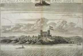
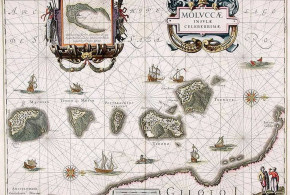
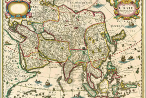
– Valentijn, François, “Oud en Nieuw Oost-Indiën, vervattende een naaukeurige en uitvoerige verhandelinge van Nederlands mogentheyt in die gewesten, benevens eene wydluftige beschryvinge der Moluccos, Amboina, Banda, Timor, en Solor, Java, en alle de eylanden onder dezelve landbestieringen behoorende; het Nederlands Comptoir op Suratte, en de levens der Groote Mogols; als ook een keurlyke verhandeling van ‘t wezentlykste, dat men behoort te weten van Coromandel, Pegu, Arracan, Bengale, Mocha, Persien, Malacca, Sumatra, Ceylon, Malabar, Celebes of Macassar, China, Japan, Tayouan of Formosa, Tonkin, Cambodia, Siam, Borneo, Bali, Kaap Der Goede Hoop en van Mauritius. Te zamen dus behelzende niet alleen een zeer nette beschhryving van alles, wat Nederlands Oost-Indiën betreft, maar ook ‘t voornaamste dat eenigzins tot eenige andere Europeërs, in die gewesten, betrekking heeft” 3500 pp., Folio, 5 parts in 8 vols., 8 folding tables, 24 engraved maps, most of them folding, 265 engraved plans, views, portraits and plates of plants, animals, costumes, etc., of which many are double-page and/or folding and 78 engravings in the text, J. van Braam, G. Onder de Linden, 1724-1726, Dordrecht and Amsterdam, The Netherlands. The most extensive geographical and historical description of the whole area of the Dutch V.O.C. had taken into possession or had gained a foothold in: the East Indies, parts of China, Japan, parts of the Near East, and the Cape of Good Hope. This work still is the main source for the early history of the East Indies, especially for Ambon, where the author lived for years, as well as for the Moluccas, Ceylon, Japan, China, the Cape of Good Hope etc. Amboina is described with special devotion and detail and is explained by the fact that the author, Franciscus Valentijn (1666-1727), lived at Amboina during almost his whole period of service in the VOC as a minister of the church. He served 2 periods from 1684 till 1695 and from 1705 till 1714 and resided at Amboina from 1686 till 1694 and from 1707 till 1712. The work presents many documents, which now are lost and contains interesting statistics on the products and the trade in the various countries. It also contains the accounts of two early voyages to Australia with interesting maps. And last but not least the work also is of great interest today for its rich and beautiful illustrations, its early maps and views, engraved by the best Dutch artists of the time, such as F. Ottens, J.C. Philips, J. Goeree, G. Schoute and J. Lamsvelt etc., mostly after designs by M. Balen. Index: Volume I (Introduction and Part I): – Preliminaries and introduction with the portrait of the author, a large folding general map of the East Indies, 2 other maps and 2 views. – Geographical and historical descriptions of the Moluccas with an extensive description of Ternate, Tidore, Batsjan, Makjan and Motir and other isles. —– It also tells the history and other interesting events that occurred. With 7 maps, plans, views and other illustrations and 12 smaller engravings in the text. Volume II (Part II): – The geography of Amboina and other isles, like Ceram, Boero, Amboina, Honimoa, Noessa-laoet, Oma, Manipa, Bonoa, Kelang etc., with an account of the habits, costumes and ceremonies of the natives and a summary of the most important historical events. These accounts are illustrated with 20 maps, plans, views and plates, illustrating people and other scenes of life etc. on Amboina, as well as 10 smaller engravings in the text. Volume III (Part III, 1): – A religious history of Amboina with a description of all the temples and religious ceremonies in Amboina. – An extensive description of the flora and fauna on Amboina such as trees, plants and mammals and the fish and other creatures living in the seas near the isles of Amboina. All very beautifully and in every detail illustrated on 78 plates. Volume IV (Part III, 2): – A treatise on shells and sea-plants existing near Amboina, with full descriptions of all the conchifera found near Amboina based on Rumphius’s Ambonsche Rariteit-Kamer. Illustrated with 17 plates. – A detailed geographical and historical description of the isles Banda, Timor and Solor, Celebes (or Macassar), Borneo, Bali, the kingdoms of Tonkin, Cambodia and Siam and the trade of the Dutch with those regions. Accompanied by 25 views, maps, plans and plates and 10 smaller illustrations in the text. The description of Banda includes an account of several expeditions as well as the first complete accounts of Abel Tasman’s voyage made in 1642-1643, with a map made after his own notes, and the voyage made by Willem de Vlamingh. Volume V ( Part IV, 1): – Description of Java and descriptions of Bantam and Batavia, with biographies of the Governors General, East-Indian coins and a list of VOC employees etc., with 28 maps and plans, views of buildings, illustrations of temples and gods; also with 21 full-page engraved portraits of the Governor General and 6 smaller engravings in the text. This volume contains 2 extra plates showing the isle Onrust, near Batavia and the harbour of Batavia, the 2 main ports of the Dutch in Indonesia. Both designed by K. Kobell Jr. and engraved by M. Sallieth. The plates were made for the Atlas van de zeehavens der Bataafsche Republiek by De Jong and Sallieth, 1802, the only and at the same time most luxurious and beautiful large-plate atlas of Dutch sea-ports published in the Netherlands. Volume VI (Part IV, 2): – Account of the religion on Java, description of the Dutch comptoir in Surat and accounts of lives of the great Moghuls with 1 map and 19 full-page portraits of Moguls, their wives and their children and 19 smaller text illustrations. – Description of China and Formosa (or Taiwan), illustrated with a map, a plan and a view and 6 smaller engravings in the text. – Account of the voyages made by Valentijn himself. Volume VII (Part V, 1): – Descriptions of the coast of Coromandel at the south-east coast of India with information about several main ports like Pegu, Arrakan and Mocha in Yemen. – Descriptions of the Dutch settlements in Persia, Malaya and Sumatra. An extensive geographical report of Ceylon. This last part contains reprints of many original documents, with 24 plates, maps and views and 10 small text illustrations. Volume VIII (Part V, 2): Descriptions of Malabar, Japan and the Cape of Good Hope, with a list of VOC employees. These accounts give early and very detailed descriptions of the mentioned regions in the Far East and southern parts of the Atlantic Ocean around South Africa and Mauritius. With 19 maps, views and other plates and 10 text illustrations.
– van Santen, H. W., “Trade between Mughal India and the Middle East and Mughal monetary policy, ca. 1600-1660”, in: “An Expanding World”, Vol. n° 10. Prakash, Om, “European commercial expansion in early modern Asia”, pp. 167-176. Also in: “Asian trade routes”, London, 1991, pp. 87-95.
– Ward, K., “Bandieten and Bannelingen: penal and political transportation in the Dutch East India Company’s Indian Ocean Empire, c. 1655-1795”, Australian Humanities Review. Abstract of a paper presented at the interdisciplinary conference “Colonial places, convict spaces: penal transportation in global context, ca. 1600-1940”, 9-10 December 1999, Department of Economic & Social History, University of Leicester, United Kingdom.