This post is also available in:
![]() Português
Português
Written by Marco Ramerini. English text revision by Dietrich Köster.
Continued from: The French attempt
7.0 THE CONSOLIDATION OF THE DUTCH PRESENCE
This period of instability resulted in a remarkable decrease of the volume of commerce, dealt with Trincomalee. The figures of this decline are inconsistent, but it seems that in the first ten years of Dutch occupation the commerce of clothes had decreased from 480.000 Dutch Guilders, when Kottiyar was under Kandyan control, to 5.342 Dutch Guilders in 1681.
The importance of the Kandyan commerce is surely exaggerated. Also according to S. Arasaratnam, however, the contrast between the two figures is striking. The Kingdom of Kandy found all its ports under Dutch control. Trincomalee, Batticaloa and Kottiyar were in Dutch hands, while Puttalam situated on the western coast was easily controllable by the Dutch fort Kalpitiya. The districts of Trincomalee, Batticaloa and Kottiyar were very important from the point of view of agricultural production, in particular for rice growing. Apart from this the mentioned districts cared for the self-sufficiency of the feeding of the local population and the Dutch garrisons. The agricultural products were exported and also used for the sustenance of the city of Colombo.1
From the administrative point of view the eastern coast was initially put under the jurisdiction of the commander of Jaffna, then, in 1671, the Dutch instituted a new ‘Commandment’ containing the entire eastern coast, whose capital was Batticaloa and in which was also included Trincomalee. This district was abolished a few years later and the entire eastern coast newly returned under the administration of Jaffna. In Trincomalee resided an ‘Opperhoofd’.2, who was assisted by a council. He governed the city and the surrounding area. He was under the authority of the commander of Jaffna.3 Regarding the administration of justice during the VOC period, Trincomalee was the seat of a law court (‘Landraad’) and it seems that the Dutch had established in Trincomalee a High Court of Justice (‘Raad van Justitie’) in the second part of the 18th century. However, it depended for the more important cases on Colombo.4
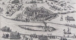
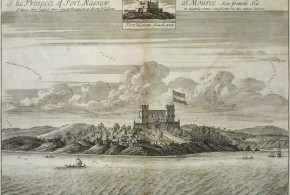
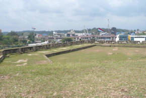
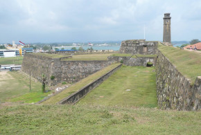
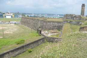
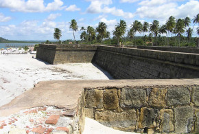
After the expulsion of the French, the fort of Trincomalee had an equipment of 100 pieces of artillery and a garrison of approximately 350 soldiers.5 In August 1696 in the two forts of Batticaloa and Trincomalee were stationed 236 men, consisting partly of the Dutch force and also of the crews of three sloops, anchored at Trincomalee.6 In 1716 the fort of Trincomalee was considered by Governor Becker in sufficient state of defence, even if some defensive works were still far from being completed. To better the defence of the bay of Trincomalee after the French episode, it was decided to build another fort in addition to that of Trincomalee (Pagoodsberg). In this second fort were 32 pieces of artillery and 30 soldiers.7 This new fort was built a few years after the expulsion of the French on a hill to the east of the entrance of the inner bay, to protect the bay against eventual incursions. The fort was called Fort Oostenburg. It was governor Becker who described us in his memories for the year 1716 the Fort Oostenburg as a small stone fortress, situated on a hill east of the entrance to the inner bay, whose mission was the defence of the access to the inner bay.8 To block the access to the bay a fortified dam (waterpaas) was then built on the west side of the entrance of the bay. On the island ‘Dwars-in-de-weg’, was finally erected a battery. Additionally two other fortifications (breastworks) were located on the other side of the bay (Koddiyar). These fortifications had a garrison of 30 soldiers and 16 guns each. On the south side of the Velos Bay two stockades were located at Cuchar and Arsalari. They were used for levying taxes, equipped with 16 guns and manned by 40 soldiers each.9 In the vicinity of Trincomalee at Erekelenchene (3/4 of a mile from Kottiyar, 1 mile to the south of the bay of Trincomalee) the Dutch had constructed an entrenchment.10
In 1696, seen the critical state of the commerce along the eastern coast and the vibrating Kandyan protests, the Dutch decided to reintroduce the free trade for the ports of Kottiyar and Batticaloa. This led to an immediate advance in the relations with Kandy and there was also an evident development in the volume of the traffic passing through the above-mentioned ports. Kottiyar and Batticaloa returned to be together with Puttalam on the west coast the gates of Kandy to the outside world. Unfortunately for the Kandyans the development of their ports strongly declined compared to those directly controlled by the Dutch company. This could not be permitted. Therefore already in 1703 the VOC decided to close anew the ports to foreign trade.
After the Portuguese defeat the Catholic Church had been forced to abandon to themselves the thousands of Catholics converted. At the end of the 17th century a new apostolate began in Ceylon with the oratories friars of Goa and mainly thanks to the mission of the friar João Vaz, called the apostle of Ceylon. Around 1695 and then in 1710 Trincomalee was twice visited by the friar João Vaz. He founded in the area various chapels and administered the sacraments to the Catholic community. He visited apart from Trincomalee Batticaloa and Kottiyar. In a letter dated 1697 11, he indicated in Kottiyar the place where a chapel and a community of one hundred Christians were to be located. Irregularly starting from the beginning of the 18th century, friars were sent to the region of Trincomalee and Kottiyar. In 1714 another friar, Miguel Francisco, visited the Christians of Trincomalee. Still in 1728 another friar, João de Sá, succeeded in reaching Trincomalee and Kottiyar in spite of the vigilance of the Dutch.12 In the following years the contacts between the friars and the Catholic population in the district of Trincomalee were multiplied: friar Joseph Pereira was active in the years 1733 and 1734, while friar Custódio Leytão, friar Francisco de Monroy, friar João de Silveira are only some of the friars, who worked or visited Trincomalee and its district in the years between 1733 and 1762.13
The closing of the ports to direct commerce with Kandy favoured the development of smuggling, rewarding mainly on the east coast of the island, where the Dutch exercised a minor control. The contraband was exercised mainly in the three ports of Alembiel (Alampil), Chialwatte and Moletivo (Mullaitivu). Trying to stop this commerce it was ordered to send during the change of the monsoon some sloops from Jaffna to cruise off the waters in front of these bays. At Mullaitivu, a bay situated half way between Jaffna and Trincomalee, the Dutch built a small fortification (It was a small structure of wood with palisades and earth.) in 1715, to block the Wannias, the Muslim merchants and the Chetties to use this bay to practice illegally the commerce with Kandy. 24 European soldiers with an insign and two sergeants and 20 lascarins with their commander were stationed in the small fortification.14
During the Dutch period a badly maintained path connected Trincomalee to Jaffna, leading through Mullaitivu. In 1749 the Dutch outpost Tambalagama in the vicinity of Trincomalee was attacked and burnt by the Kandyans. Subsequently in 1751 the Kandyans also tried to block the commerce with Koddiyar and Tambalagama.
In line with this Jan Schreuder wrote in his memories: The bay of Trincomalee was the centre of a little pearl bench, but the income of the region was mainly generated from the arrack, the customs duties and the garden cultivated by the company.15 In his momories Schreuder also described the state of the fortifications of Trincomalee. The ditch of the fort had not yet been finished and because of the lack of workers the “waterpas” under the fort Oostenburg had still to be finalized. The same regards the fort itself.16
Starting in 1760 the English often used the bay of Trincomalee as an anchorage for their fleet. In those years (1762) an English envoy, John Pybus, disembarked in Kottiyar and arrived in Kandy. This English intrusion disturbed the Dutch, who were in open war with Kandy. They were afraid of an alliance between the English and Kandy.
During the war with Kandy (1761-1766), the Dutch used Trincomalee as a base for the incursions into the Kandyan territory. In 1763 the territories under Dutch control extended to the interior as far Minneriya and Madavacchiya. Moreover Dutch troops from Trincomalee succeeeded in occupying Matale. By the terms of the peace treaty of 1766 the lands of Tamblagam, Kottiyar and Kattekolapattu became Dutch possessions, also the area controlled by the Dutch around Batticaloa extended remarkably: the Dutch were successful in controlling important agricultural districts (where rice was mainly grown) at the outskirts of Trincomalee and Batticaloa. Furthermore the peace treaty carried the Dutch control along all the coast of the island. Kandy found itself landlocked without an access to the sea and encircled by the territories of the company. With this treaty the Dutch completely controlled the Kandyan commerce and the external relations of the Kingdom of Kandy. Moreover Kandy depended on the company for the essential supplies of salt and dry fish. The territory around Batticaloa, which the Kingdom of Kandy had controlled until 1763-1766, was of great importance for the subsistence of the kingdom. In fact the fertile plains of the province of Batticaloa were called the granary of Kandy. The loss of the control of these large-scale cultivated plains definitively happened with the treaty of 1766. This entailed a remarkable impoverishment of the Kingdom of Kandy. During the war with Kandy the composition of the Dutch garrisons of the island had been remarkably increased. The same happened to the two main forts of the eastern coast Trincomalee and Batticaloa. In 1764 they had together a garrison of 881 soldiers, of which 448 were Europeans, 228 Orientals and 205 Sepoys .17
After the conquest of the new agricultural territories at the outskirts of Trincomalee the Dutch intended to restore the old tanks of Kantalai and Vendarasen Kulam to be anew able to develop the agricultural potentialities of the district. Also for this purpose a map of the province of Tamblegam was drawn in 1793 by the surveyor Struys and the engineer Fornbauer. The latter was the last Dutch commander of Trincomalee.18
In 1777 the king of Kandy, Kirti Sri Rajasinha, started new negotiations with the French. He addressed the French governor of Pondicherry (Pondichéry) offering the bays of Trincomalee and Batticaloa in exchange for a French aid to drive away the Dutch from the island. The French took the offer in serious consideration, but the outbreak of the war between Great Britain and Holland, France fighting alongside his ally Holland, put a stop to the negotiations.
To be continued by: The first British occupation and the definitive Dutch surrender

Fort Oostenburg (1726), Trincomalee, Sri Lanka. Author Valentijn 1726c
NOTES:
1 “Memoirs left by Riclof van Goens, Jun. 1675-1679”. p. 5.
2 European official at the head of a small district.
3 “History of Sri Lanka”, vol. II, pp. 346-347.
4 “History of Sri Lanka”, vol. II, pp. 356-374.
5 Queyroz “The temporal and spiritual…”, vol. III, p. 1196.
6 “Memoir of Thomas van Rhee, 1697”, pp. 52-53.
7 Queyroz “The temporal and spiritual…”, vol. III, p. 1196.
8 “Memoir of Becker, 1716”, pp. 26-27.
9 Queyroz “The temporal and spiritual…”, vol. III, p. 1196.
10 Dutch map is testimony of this, it can be found at the Rijksarchief Eerste Gedeelte ‘s-Gravenhage.
11 Perniola “The Catholic Church in Sri Lanka: the Dutch period, 1658-1711”, vol. I p.122.
12 Vedi Boudens “The Catholic Church in Ceylon under Dutch rule”, pp. 89-131.
13 Vedi Boudens “The Catholic Church in Ceylon under Dutch rule”, pp. 132-157.
14 “Memoir of Becker, 1716”, p. 17.
15 Schreuder, J. “Memoir of Jan Schreuder”, p. 89.
16 Schreuder, J. “Memoir of Jan Schreuder”, p. 91.
17 Raven-Hart “The Dutch wars with Kandy, 1764-1766”, p. 56.
18 Brohier “Land, maps and surveys”, pp. 135-136; Brohier “Links between Sri Lanka and The Netherlands”, p. 128.
This post is also available in:
![]() Português
Português