Written by Marco Ramerini. English text revision by Dietrich Köster.
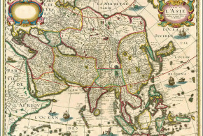
INDIA:
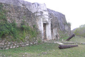
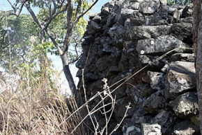
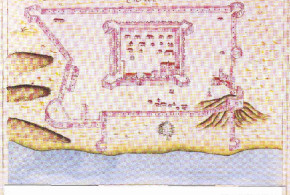
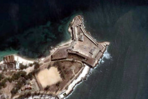
Diu: (20°43’N – 71°00’E) Forte or Castelo do Mar, Castelo de Diu or Fortaleza de São Tomé
Portuguese: 21 Dec. 1535 fortress – 18/19 Dec. 1961
Leao “A Província do Norte do Estado da Índia”
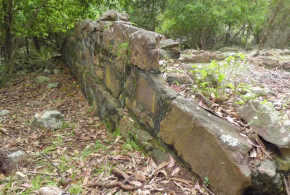
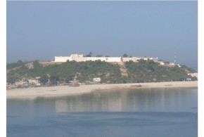
Island of Diu: Fortaleza de Nagoa (1744), Fortaleza de Brancavara (1774), Forte de Simbor, Forte de Gogola.
Portuguese: 1554 – 18/19 Dec 1961
Leao “A Província do Norte do Estado da Índia”
Bulsar or Balsar (Valsad ?): (20°37’N – 72°55’E)
Portuguese: 1559 fort – 1560 abandoned
Danvers “The Portuguese in India”
Parnel (Parnera ?): (20°33’N – 72°57’E) three leagues from Daman
Portuguese: 1559* the fort is conquered and then razed to the ground
Leao “A Província do Norte do Estado da Índia” * 1569 according to Danvers “The Portuguese in India”
Damão Grande or Praça de Damão (Damão, Moti Daman or Daman): (20°25’N – 72°50’E) Castelo de Hieronymus
Portuguese: 1559 fort – 18/19 Dec.1961
Rossa “Indo-Portuguese cities” Leao “A Província do Norte do Estado da Índia” Danvers “The Portuguese in India”
Damão Pequeno (Nani Daman): (20°26’N – 72°50’E) Forte de São Jerónimo (1614/15)
Portuguese: 1614/5 fort – 18/19 Dec 1961
Rossa “Indo-Portuguese cities “Leao “A Província do Norte do Estado da Índia”
Dadrá: (20°19’N – 72°58’E)
Portuguese: 1779 – 24 July 1954
Rossa “Indo-Portuguese cities”
Nagar Haveli:
Portuguese: 1779 – 2 Aug. 1954
Rossa “Indo-Portuguese cities”
São Gens or Samges:
Portuguese: round fortress with 6 bastions
Umbargão (Umargam): (20°12’N – 72°45’E)
Portuguese: fort – Nov. 1738
to Marathas
Leao “A Província do Norte do Estado da Índia” Danvers “The Portuguese in India”
Danu (Dahanu): (19°58’N – 72°44’E) round fort with a bulwark
Portuguese: 1533 ? 1560c. fort – November 1738
to Marathas
Danvers “The Portuguese in India” Naravane “The maritime and coastal forts of India”
Trapor or Tarapor (Tarapur): (19°53’N – 72°41’E) fort with round and square bastions
Portuguese: 15 ? – 1739
to the Marathas
Gerson de Cunha “Notes on the history of Chaul and Bassein” Danvers “The Portuguese in India”
Kari de Chikli or Tchikla (Chinchani ?): (19°53’N – 72°41’E) ?
Portuguese: square fort with 4 bastions
Gerson de Cunha “Notes on the history of Chaul and Bassein” Naravane “The maritime and coastal forts of India”
Serra de Açarim, Azarim or Aserim:
Portuguese: 1556 tranqueira, mountains fort – 13 Feb. 1739
to the Marathas
Gerson de Cunha “Notes on the history of Chaul and Bassein” Danvers “The Portuguese in India”
Manora’ or Manori: round fort
Portuguese: 1556 fort – ?
Danvers “The Portuguese in India”
Sirgão or Seridão (Shirgaum): (19°44’N – 72°44’E)
Portuguese: ? – 1739
to the Marathas
Danvers “The Portuguese in India” Naravane “The maritime and coastal forts of India”
Mahim: (19°39’N – 72°44’E) round fort
Portuguese: 1532 – 20 January 1739
to Marathas
Gerson de Cunha “Notes on the history of Chaul and Bassein” Danvers “The Portuguese in India”
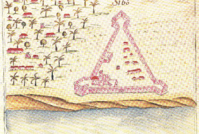
Kari de Mahim: small triangular fort with two bastions
Portuguese: ? – ?
Gerson de Cunha “Notes on the history of Chaul and Bassein”
Quelme (Kelve): (19°35’N – 72°45’E)
Portuguese: ? – 1739
to the Marathas
Leao “A Província do Norte do Estado da Índia” Danvers “The Portuguese in India”Naravane “The maritime and coastal forts of India”
Ilha das Vacas (Arnalla): (19°28’N – 72°44’E) circular tower
Portuguese: ? – 13 February 1739
to Marathas
Gerson de Cunha “Notes on the history of Chaul and Bassein” Naravane “The maritime and coastal forts of India”
Asserim or Agaçaim (Agashi): (19°28’N – 72°47’E)
Portuguese: fort and custom house
Gerson de Cunha “Notes on the history of Chaul and Bassein” Naravane “The maritime and coastal forts of India”
Sopera or Supara (Sopara): (19°25’N – 72°47’E)
Portuguese: four wooden stockades
Gerson de Cunha “Notes on the history of Chaul and Bassein”
Saibana:
Portuguese: stockade
Gerson de Cunha “Notes on the history of Chaul and Bassein”
Bassein or Baçaim (Vasai): Cidadela de São Sebastiao (19°20’N – 72°49’E)
Portuguese: 1528 sacked, 1532 conquered and abandoned, 23 December 1534 ceded by a treaty
Portuguese: May 1536 fortress – 16 May 1739 surrender, 23 May 1739 the Portuguese leave the town
Leao “A Província do Norte do Estado da Índia” Danvers “The Portuguese in India”
Galiana (Kalyana): (19°14’N – 73°10’E)
Portuguese: 1535 – lost a short time after
Gerson de Cunha “Notes on the history of Chaul and Bassein”
Salsette Island:
Portuguese: 1534 – 1737
to Marathas
Gerson de Cunha “The origin of Bombay”
Thana (Salsette Island): (19°11’N – 72°58’E) two towers (São Pedro and São Jeronimo) and one small square fort (Reis Magos) with two bastions.
Portuguese: 1534 – 1737
to Marathas
Gerson de Cunha “Notes on the history of Chaul and Bassein”
Portuguese: There were three bulwarks near Thana: Forte Santa Cruz (Salcete is.), Forte do Passo Seco or do Rio (in front of Thana), Baluarte do Mar (in the direction of Bombay)
Gerson de Cunha “Notes on the history of Chaul and Bassein”
Bandora:
Portuguese: Torre Agoada (1640s.) small watch tower
Gerson de Cunha “Notes on the history of Chaul and Bassein”
Dharavi Island: (19°16’N – 72°50’E) ?
Portuguese: fort
Gerson de Cunha “Notes on the history of Chaul and Bassein” Naravane “The maritime and coastal forts of India”
Versova Island:
Portuguese: fort
Gerson de Cunha “Notes on the history of Chaul and Bassein”
Bombaim or Mobaim (Bombay): (18°55’N – 72°50’E) quadrangular fort
Portuguese: 1534 ceded by treaty – 18 February 1665
to the British by treaty
Belaflor, Sambayo or Sabayo (Belapur): (19°01’N – 73°02’E)
Portuguese: fortification
Gerson de Cunha “Notes on the history of Chaul and Bassein” Naravane “The maritime and coastal forts of India”
Caranja or Juem: circa (18°54’N – 72°55’E) There were 2 forts, one, smaller, on the east side of the island, the other, bigger, on a hill, was a square fort, three angles, of which each had a bastion each.
Portuguese: – 28 March 1739
to Angria
Danvers “The Portuguese in India” Gerson de Cunha “Notes on the history of Chaul and Bassein”
Portuguese: From Bassein to Caranja there were 14 Portuguese forts or towers. Gerson de Cunha “Notes on the history of Chaul and Bassein”
In 1739 the Portuguese lost: 20 fortresses, 2 fortified hills, 8 towns. Danvers “The Portuguese in India”
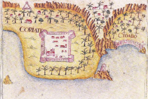
Chaul (Revdanda): (18°33’N – 72°56’E) Fortaleza de Santa Maria do Castelo
Portuguese: 1503 feitoria ?, 1509 vassal, 1516 feitoria, 1521 fort, October 1531 fortress – 18 September 1740
transfer by treaty to the Marhattas
Rossa “Indo-Portuguese cities” Danvers “Portuguese in India” Naravane “The maritime and coastal forts of India”
Morro de Chaul (Korlai): (18°32’N – 72°55’E) Fortaleza do Morro de Chaul
Portuguese: 1594 the fortress was conquered – 1739
Rossa “Indo-Portuguese cities” Naravane “The maritime and coastal forts of India”
Goa: At the beginning of 17th century the Portuguese ruled over a territory of about 275 square miles. Disney “Twilight of the pepper empire”
Portuguese: 4 March 1510 – 20 May 1510
Portuguese: 25 November 1510 – 18/19 Dec. 1961
to India
Rossa “Indo-Portuguese cities” Salcete or Salsete: 1543 – Rossa “Indo-Portuguese cities”
Bardez (Goa):
Portuguese: 1543 – ?
Rossa “Indo-Portuguese cities”
Reis Magos or Magus (Bardez, Goa):
Portuguese: 1550s. – ?
Aguada or Agoada (Bardez, Goa): Forte Santa Caterina (1604)
Portuguese: 1604 – ?
Alorna (Goa): fort
Portuguese: 5 May 1746 – ?
Danvers “The Portuguese in India”
Nossa Senhora do Cabo (near Aguada fort, Goa): rectangular fort
Gaspar Dias, St. Ignes (Panjim, Goa): square fort (1598)
Portuguese: 1598 – ?
Mormugão (Goa): fort (1624)
Portuguese: 1624 – ?
Rachol (Salcete, Goa):
Portuguese: Fortress of Indian origin with Portuguese additions (1604)
Torre de Noroa (Goa):
See: “Os Portugueses no Malabar” p. 59 note 64
Neutim fort (Goa):
Portuguese: 1746 – ?
Rarim fort (Goa):
Portuguese: 1746 – ?
Cabo do Rama (Goa):
Portuguese: Fort
Chapora (Goa): fort (1617)
Portuguese: 1617 – 1684
Portuguese: ? – 1739
Portuguese: ? – 1961
Tiracol (Tarekhol, Goa): fort (1746)
Portuguese: 1746 – 15 Aug. 1954 for a few hours is occupied by the Indians, a few hours after it is taken up by the Portuguese
Cintacola or Cintacora (Sadashivgad, Goa): (14°51’N – 74°07’E) Forte de Pito or Piro
Portuguese: 30 Jan. 1791 – 16 Mar. 1793
to Tipu Sultan
Naravane “The maritime and coastal forts of India” Danvers “The Portuguese in India”
Angediva (Anjediv): (14°49’N – 74°03’E) Forte Nossa Senhora das Brotas (1682)
Portuguese: 14 Sep. 1505 fort – 1506/7 abandoned
Portuguese: 5 May 1682 fort – 20 Dec.1961
to India
Danvers “The Portuguese in India”
Onor (Honawar): (14°17’N – 74°26’E) Fortaleza de Santa Catarina (1568/9)
Portuguese: 1568/9 fort – 1654
Disney “Twilight of the pepper empire”
Gersoppa (30 miles upstream of Onor): (14°15’N – 74°39’E)
Portuguese: Casa do Peso
Disney “Twilight of the pepper empire”
Bhatkal: (13°59’N – 74°32’E)
Portuguese: 1514 the harbour is dismantling, 1542 conquered and after two days abandoned and burnt, 1548 tributary
Danvers “The Portuguese in India”
Barcelor or Braçalor (Basrur): (13°38’N – 74°44’E) square shaped fortress.
Portuguese: 1568/9 fort – 1652
to Ikerri
Disney “Twilight of the pepper empire”
Cambolin (Coondapoor, near Barcelor): (13°38’N – 74°41’E) square shaped fortress.
Portuguese: 1629 fort – 15 Jan 1653
to Ikerri
Disney “Twilight of the pepper empire” Danvers “The Portuguese in India”
Mangalore (Mangalor): (12°54’N – 74°50’E) Forte São Sebastiao (1567/68/69) square shaped fortress with a bastion at every corner.
Portuguese: 1568/9* fort – 165?
Portuguese: feitoria (there was in 1750)
Danvers “The Portuguese in India” Disney “Twilight of the pepper empire” * 1567 Danvers “The Portuguese in India”
Mount Delly (Ettikulam): (12°05’N – 75°11’E)
Portuguese: fort ?
Naravane “The maritime and coastal forts of India”
Cannanore or Cananor: (11°51’N – 75°22’E) Fortaleza de Santão Gil or Santo Angelo (1505)
Portuguese: 1501 ally of Portugal and feitoria, Oct. 1505 fort – 15* Feb. 1663 (*13 Feb. 1663 according to Danvers “The Portuguese in India”)
to The Netherlands
Correia “Os Portugueses no Malabar 1498-1580” Koshy “Dutch power in Kerala”
Calecut or Calicut (Kozikode): (11°15’N – 75°47’E)
Portuguese: 1514/15 fort – 1525* (*1522-1525 according to Disney “Twilight of the pepper empire”)
Portuguese: feitoria (there was one in 1750)
Danvers “The Portuguese in India” Correia “Os Portugueses no Malabar 1498-1580”
Chalé or Chale (Chalyam or Beypore): (11°09’N – 75°49’E) rectangulare shaped fort
Portuguese: 1531 fort – 1571
Disney “Twilight of the pepper empire” Correia “Os Portugueses no Malabar 1498-1580”
Ponanni or Panane: (10°46’N – 75°55’E)
Portuguese: 1535 attempt to build a fort, never finished.
Disney “Twilight of the pepper empire”
Cranganore or Cranganor (Kodungallor): (10°13’N – 76°13’E) Castelo de São Tomé (1536) square-shaped fort
Portuguese: 1536 fort – 15 Jan. 1662
to The Netherlands
Correia “Os Portugueses no Malabar 1498-1580” Koshy “Dutch power in Kerala” Danvers “The Portuguese in India”
Cochin de Cima (Pallipuram): (10°10’N – 76°11’E) Castelo de Cima (1502 ?)
Portuguese: 1502 ? fort – 16 Feb. 1661
to The Netherlands
Correia “Os Portugueses no Malabar 1498-1580” Danvers “The Portuguese in India”
Cochin, Cochin de Baixo or Santa Cruz: (09°57’N – 76°15’E) Fortaleza Manuel (1503)
Portuguese: 1501 ally of Portugal, 26/27 Sep. 1503 timber fortress, 1505/6 stone fortress – 7/8 Jan. 1663
to The Netherlands
Correia “Os Portugueses no Malabar 1498-1580” Koshy “Dutch power in Kerala” Danvers “The Portuguese in India”
Rossa “Indo-Portuguese cities” (27 Sep. 1503 timber fortress, 3 May 1506 stone fortress)
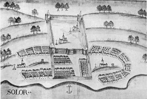
Coulão or Coullam (Quilon): (08°53’N – 76°35’E) Forte São Tomé or Tangesseri (1518)
Portuguese: 1505 feitoria, 1518 fortress – 29 Dec. 1658
to The Netherlands (29 Dec. 1658 – 14 Apr. 1659)
Portuguese: 14 Apr. 1659 – 24 Dec. 1661
to The Netherlands
Correia “Os Portugueses no Malabar 1498-1580” Koshy “Dutch power in Kerala” Danvers “The Portuguese in India”
Punicale (Punnaikayal): Punicale was the chief Portuguese settlement of the Fishery Coast between 1532 and the 1580s; from about the 1580s their chief settlement was Tuticorin.
Portuguese: settlement 1532c. fort – 1552
Portuguese: 1553 – ?
Caldwell “A history of Tinnevelly”
Tuticorin or Tutucorim: (08°48’N – 78°09’E) Punicale was the chief Portuguese settlement of the Fishery Coast between 1532 and 1580s; from about 1580s their chief settlement was Tuticorin.
Portuguese: settlement 1532c., Portuguese governor 1542c. – Feb. 1658
to The Netherlands
Danvers “The Portuguese in India” Caldwell “A history of Tinnevelly”
Nagapatão or Negapatão (Negapatam or Nagapattinam): (10°47’N – 79°50’E)
Portuguese: 1520/30s. settlement, 1642/43 fort and custom house – 23 July 1658
to The Netherlands
Subrahmanyam “The South Coromandel Portuguese in the late 17th…” in Studia n° 49 Danvers “The Portuguese in India”
Porto Novo (Parangi-Pettai): (11°29’N – 79°46’E)
Portuguese: 1590s. settlement – 18th. ?
Diffie-Winius “Foundation of the Portuguese empire 1415-1580” Subrahmanyam “The South Coromandel Portuguese in the late 17th…” in Studia n° 49 Subrahmanyam “Improvising Empire – Portuguese trade and settlements in the Bay of Bengal 1500 – 1700” or “”Comércio e conflito – A presença portuguesa no Golfo de Bengala 1500 – 1700”
Tegenapatam: (11°44’N – 79°47’E)
Portuguese: fort ?
Raychaudhuri “Jan Company in Coromandel 1605-1690” p. 19
São Tomé de Meliapor: (13°00’N – 80°15’E)
Portuguese: 1522/3 settlement, 1614 fort – 1662
to Qutbshahi (Golconda) (1662 – 1672)
to the French (1672 – 6 September 1674)
to The Netherlands (6 September 1674 – 10 October 1674)
to the Qutbshahi (Golconda) (10 October 1674 – 1687)
Portuguese attempt to reestablish a Portuguese settlement: 1687 – 21 Oct. 1749
to the British (21 October 1749 – ?)
Lotika Varadarajan “San Thomé: early European activities and aspirations” Diffie-Winius “Foundation of the Portuguese empire 1415-1580” Subrahmanyam “The South Coromandel Portuguese in the late 17th…” in Studia n° 49 Subrahmanyam “Improvising Empire – Portuguese trade and settlements in the Bay of Bengal 1500 – 1700” or “”Comércio e conflito – A presença portuguesa no Golfo de Bengala 1500 – 1700”
Paliacate or Paleacate (Pulicat): (13°24’N – 80°19’E)
Portuguese: 1518 settlement – 1600s.
Dutch factory: (Apr. 1610 – 12 Jun. 1612)
Portuguese: 12 Jun 1612 conquered and destroyed by the Portuguese and abandoned
Subrahmanyam “Improvising Empire – Portuguese trade and settlements in the Bay of Bengal 1500 – 1700” or “”Comércio e conflito – A presença portuguesa no Golfo de Bengala 1500 – 1700” Diffie-Winius “Foundation of the Portuguese empire 1415-1580” Subrahmanyam “The South Coromandel Portuguese in the late 17th…” in Studia n° 49
Masulipatam or Masulipatão: (16°11’N – 81°08’E)
Portuguese: settlement
Diffie-Winius “Foundation of the Portuguese empire 1415-1580”
Portuguese: A Portuguese captain was appointed in Masulipatam between 1598 and 1605/1610 according to Subrahmanyam “Improvising Empire – Portuguese trade and settlements in the Bay of Bengal 1500 – 1700” or “”Comércio e conflito – A presença portuguesa no Golfo de Bengala 1500 – 1700”
Balasore or Balasor: (21°29’N – 86°57’E)
Portuguese: settlement
Campos “History of the Portuguese in Bengal”
Pipli: circa (21°37’N – 87°20’E)
Portuguese: 1514 settlement – ?
Campos “History of the Portuguese in Bengal”
Bandel: (22°56’N – 88°24’E)
Portuguese: 1599 friary – ?
Diffie-Winius “Foundation of the Portuguese empire 1415-1580”
Porto Pequeno de Bengala, Sategão, Satigão, Sateguam or Satigam (Satgaon): (22°57’N – 88°24’E)
Portuguese: 1536/7 customs house, feitoria – ?
Portuguese: 1590s. – ?
Campos “History of the Portuguese in Bengal” Diffie-Winius “Foundation of the Portuguese empire 1415-1580”
Ugolim, Golim or Dogolim (Hugli or Hooghly): (22°54’N – 88°24’E)
Portuguese: 1579/80 – 25 September 1632
to the Mughals
Portuguese: July 1633 new Portuguese settlement – 18th century ?
Campos “History of the Portuguese in Bengal” Diffie-Winius “Foundation of the Portuguese empire 1415-1580”
Tambolim (Tamluk or Tumlook): (22°18’N – 87°55’E)
Portuguese: settlement
Campos “History of the Portuguese in Bengal”
Angelim (Hidgelee or Hijili): circa (22°14’N – 88°03’E)
Portuguese: 1520s settlement – 1636
Campos “History of the Portuguese in Bengal”
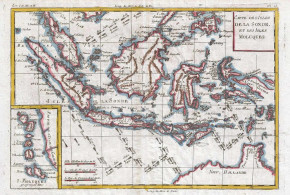
MALDIVES:
Ilhas de Maldiva, Male: (04°10’N – 73°30’E)
Portuguese: 1517/18 feitoria, 1519 wooden fort – 1519 (1521 ?)
Portuguese: 1558 fort – 1573
Bell, H.C.P. “Excerpta Maldiviana” from the Ceylon Royal Archaeological Society Journal, 1931 VOL. XXXII
BANGLADESH:
Sundiva (Sandwip island): circa (22°30’N – 91°28’E)
Portuguese: 1590s. tributary of Portugal, 1602 conquered by Portugal – 1605?
Portuguese: 1607 – 1616
Campos “History of the Portuguese in Bengal” Guedes “Interferencia e integração dos Portugueses na Birmania 1580-1630”
Porto Grande de Bengala or Chatigam (Chittagong): (22°20’N – 91°50’E)
Portuguese: 1536/7 customs house and feitoria
Portuguese: In 1590 the fort is conquered by the Portuguese – in the 1590s the Portuguese are expelled.
Campos “History of the Portuguese in Bengal”
Dianga: circa (22°15’N – 91°50’E)
Portuguese: ? settlement – 1607
Portuguese: after 1615 new Portuguese settlement
Campos “History of the Portuguese in Bengal”
Dacca: (23°42’N – 90°24’E)
Portuguese: 1580 settlement – ?
Campos “History of the Portuguese in Bengal”