Written by Chris Dunbar. All pictures are copyright by Chris Dunbar.
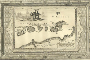
The trip to find the site of Makaha was via the town of Mutoko and then on a dirt road for 90 minutes into the growth point of Makaha. Once we left the growth point we had to resort to four wheel driving as the road turned to a track and became very treacherous due the massive amount of illegal gold mining and the trenches and holes that the illegal miners had dug. Again as with my trip to find Maramuca I was offered gold dust at every illegal gold mine.
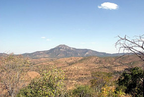
The location of this site is about five kilometres from the Ruenya River and while in the 1950’s the outer walls were still visible when I did find the site once again every thing had been obliterated by the illegal gold miners.
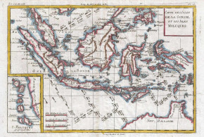
I discussed this particular site with a number of the staff from the Museums and with a number of interested parties, all agreed that this site was not actually Portuguese or at least there was very little evidence to show that it was settled by the Portuguese.
The excavations while only on a very minor scale failed to provide any further evidence of a Portuguese presence. The claim to it being Portuguese are based off a very old miners claim (1945) that he had found an earthwork similar to the ones on the Angwa River also documented in 1945.
In order for me to wonder around the bush near Makaha I had to gain permission from the local village elder and the local political commissioner and with their help I was taken to two very interesting sites, it was claimed that both sites were of Portuguese origin.
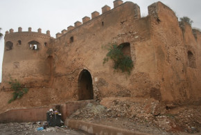
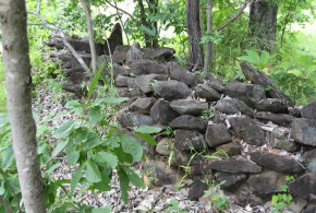
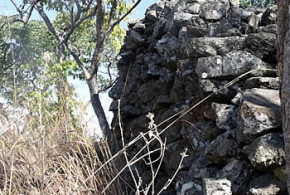
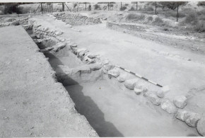
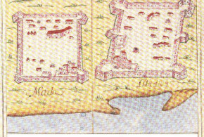
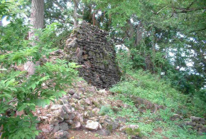
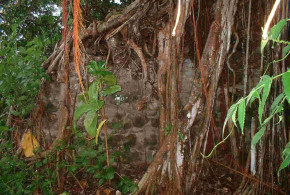
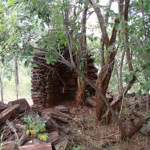
The first site was on top of a hill and was constructed of schist and was very clearly “native” I worked at the site for a number of hours and only found “native” pottery shards.
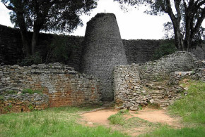
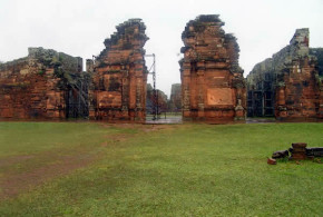
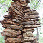
The second site was truly fantastic the walls and turrets were still standing, without the aid of cement. The outlines of the rooms were evident and the tree that was growing in the walls was at least 100 years but again I think it was too structured and when I looked on the map from the National Monuments I could not find any reference to it at all. I found no sign of Portuguese presence.
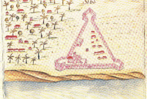
This site was north east of the Makaha site only about 2km’s. The walls are pretty much as is there were no scattered stones so the walls are close to their original height. The walls circled the top of the hill. The defensive line was probably 200 metres in circumference in the middle of the “fort” was a slight depression which I was told was were the white people of old (the village elder claimed Portuguese) had lived and to the left of that depression was a very deep shaft cut into the schist and that was a “gold” vein and the walls had been built to defend that “gold” vein. The entrance (there was only one) is clearly visible.
The elder claimed that this was a Portuguese site, to me it is clearly a stone “zimbabwe” I did not have the time to excavate, I did look at the construction and the surrounds, I was taken to number of large holes in the ground on the southern side of the hill about twenty metres below the summit and the walls and the holes were laid out in a definite pattern, the village elder said that these were graves. Now, when I sat with the village elder a few hours later and shared some water, he told me that he had only been in the area for 70 years, Makaha was well known to him as Portuguese, no Portuguese artefacts have been found and not even Blue on White Chinese Porcelain shards have been found. I think that over the years interested parties like me have come looking for the Portuguese site and he has heard the rumours and put them altogether in a jumbled story. The ruins on the hill, oral tradition states that these are Portuguese in origin. I would hazard that they were a defensive site to protect the local villages from the Portuguese.
What I did find interesting was a rumour that close to the supposed site of Makaha was a grave yard with headstones and inscriptions of Portuguese who had died in the area. I did not have time to follow this up but may make this a separate project for next year.
-
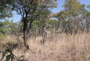
- The hill site for the site which was Shona not Portuguese. Makaha, Zimbabwe. Photo © by Chris Dunbar
-
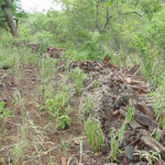
- Schist walls at Shona site. Makaha, Zimbabwe. Photo © by Chris Dunbar
-
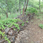
- Schist walls at Shona site. Makaha, Zimbabwe. Photo © by Chris Dunbar
-

- Schist walls at Shona site. Makaha, Zimbabwe. Photo © by Chris Dunbar
-

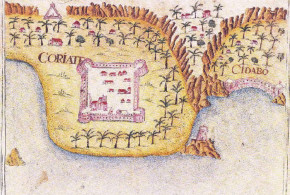
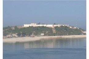
- The site of Makaha feira is behind the big trees on the left of the picture. Makaha, Zimbabwe. Photo © by Chris Dunbar
-
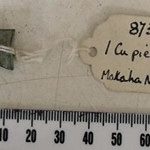
- Copper cube collected from the site. Makaha, Zimbabwe. Photo © by Chris Dunbar
-
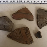
- Native pottery collected from the site . Makaha, Zimbabwe. Photo © by Chris Dunbar
MAKAHA: EARLY SETTLERS HOUSE
Written by Chris Dunbar. All pictures are copyright by Chris Dunbar.
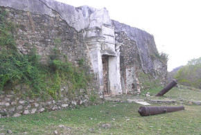
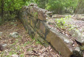
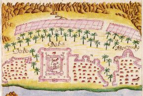
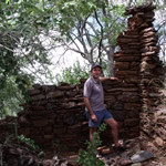
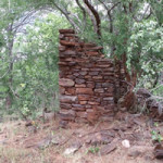
This one, I have called old settlers house. Truly I do not know who built it, I could not find it logged on the museums and monuments records.
To me after visiting Luanze, Angwa, and looking at the plans for Maramuca I just cannot bring myself to say that it is of Portuguese early origin. It is too structured and I have included pictures of the room layouts and of the “porch” layout. The walls were once very high, as can be seen using me as the height measurement.
The wall stones that have fallen are missing, not scattered so they have been carried away for another structure, I walked all over this hill and found no structures near by so they have been moved some distance away. There are a number of large trees in the house, and the type of tree suggests that they are at least 100 years old.
The village elder again claimed that this was Portuguese and he stated categorically that I was the first white man that he knew of that had visited it in all the time that he had been in the area (70 years). I was unable to excavate but after some grass clearing and surface searching I did not find anything at all to give me a datum. No pottery, no glass nothing.
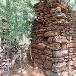
The walls are made from local rock slabs not schist as per the other site, a completely different rock strata was in this area which was north east of the Makaha site 4 km’s and probably only 2 km’s from the other schist walled site. The stones are held in place with daga / mud, no cement or concrete at all. I imagined that there must have been timber trusses for the roof (no evidence found) the hill was well wooded but the type of trees growing are not the type to grown straight so maybe straight trunks were carted in.
This is the summary from the man who went looking for the Portuguese grave stones, in Makaha:
It is very sad to hear about the fate of the feiras and I suspect many other national monuments. I hope I may be able to explain the story of the headstones. It has been preserved, I suspect, by a paragraph in a Henk Ellert’s book, Rivers of Gold which quotes me saying I had heard of such things and spent some time looking for them, both of which are true. In the 1960s when I worked in the Honde Valley I was invited by a young Carmelite priest to do a tour of the north of the province which I had never been to. One night we stayed at Katere – I think the mission was called Regina Coeli – where the missionary was a tough but charming man called Senan Egan. He did a lot of prospecting and hunting apart from running a very successful mission-farm and said that across the river (Ruenya) he had found the gable end of a church and head stones with inscriptions, both of which he took to be Portuguese. He said tsetse officers had seen them in the same area. I resolved to go and have a look one day. Then the war happened. It was the 80s before I got back. I went with Chuck Bollong, the new archaeologist at QVM and my wife. I located Fr. Egan who gave us directions but was by now too old to come too. We spent a couple of days there but apart from meeting a lot of panners and a highly eccentric family of prospectors, all we found was some ruins of German mining endeavours from the early 20th century.
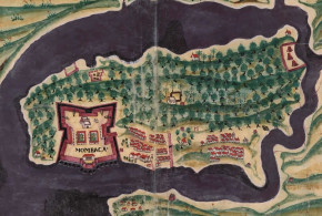
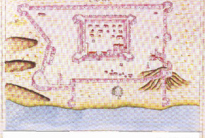
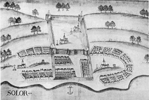
My next attempt was a couple of years later with Professor (Dave) Beach of UZ. This time we came in from the Mutoko side and hit the Makaha Feira straight away. In those days it was quite recognisable and even had a National Monuments sign on it. We spent another couple of days with the prospector but just found more of the German stuff. My conclusion after this was that what Fr Egan and the tsetse people had seen was early 20th century. This area was of course what Karl Mauch named the Kaiser Wilhelm gold field and there was a lot of early German interest. The prospector told us he had found an early Mercedes in the bush too but I am sceptical! So I think the feira is the only extant Portuguese site. What I saw was the remains of a strong point, square with star bastions on the corner. There was also a curtain wall at the entrance, but I suspect that was a later addition. There were some quite deep shafts near by.
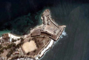
The German miners settlement is at 1720’06.90″s and 3246’09.33″e on Google Earth, below that is the schist stone iron age settlement that I found also pictures on Google Earth and about five kilometres towards the big river (Ruenya) is the Feira of Makaha which I never found.
-

- Ruins of the early settlers house Makaha, Zimbabwe. Photo © by Chris Dunbar..
-
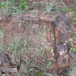
- Ruins of the early settlers house Makaha, Zimbabwe. Photo © by Chris Dunbar.
-
- Ruins of the early settlers house Makaha, Zimbabwe. Photo © by Chris Dunbar
-
- Ruins of the early settlers house Makaha, Zimbabwe. Photo © by Chris Dunbar,.,,
-
- Ruins of the early settlers house Makaha, Zimbabwe. Photo © by Chris Dunbar. .,
-
- Ruins of the early settlers house Makaha, Zimbabwe. Photo © by Chris Dunbar. ,.
-
- Ruins of the early settlers house Makaha, Zimbabwe. Photo © by Chris Dunbar. ,
-

- Ruins of the early settlers house Makaha, Zimbabwe. Photo © by Chris Dunbar. ,