Cape Verde, Colonial Forts on Google Earth, Portuguese Colonialism
3,033 Views
Photos by João Sarmento. Written by Marco Ramerini. The Cidade Velha (Old Town) of the island of Santiago in Cape Verde islands is located 15 kilometers west of the city of Praia, along the Santiago island coast. It constitutes the first city built by Europeans in the tropics and the first capital of the Cape Verde archipelago. The settlement was originally named ...
Read More »
Colonial Forts on Google Earth, Portuguese Colonialism, São Tomé and Principe
2,847 Views
Photos by João Sarmento. Written by Marco Ramerini. The Portuguese Fort São Sebastião, São Tomé, São Tomé e Príncipe. The fort was built in 1575. The fort was occupied by the Dutch on 16 Oct. 1641. The Portuguese recaptured the fort on 15 December 1644. The Fort São Sebastião is square-shaped with bastions at each corner and now houses the São Tomé and Príncipe National Museum.
Read More »
Colonial Forts on Google Earth, Morocco, Portuguese Colonialism
7,426 Views
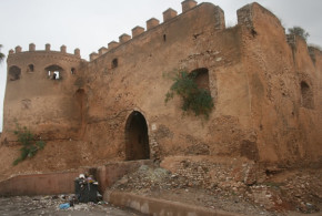
Photos by João Sarmento. Written by Marco Ramerini. Some pictures of what remains of forts built by the Portuguese in Morocco in the 15th and 16th century. Here are presented photos of Azamor (Azemmour), Safim (Safi) and Mazagão (El Jadida) taken by João Sarmento. The fort of Azamor (Azemmour) was under Portuguese control between 3 September 1513 and October 1541. The fort of Safim (Safi) called by ...
Read More »
Bahrain, Colonial Forts on Google Earth, Portuguese Colonialism
2,818 Views
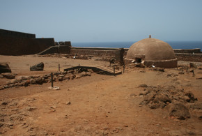
Written by Marco Ramerini. Photos by João Sarmento. English text revision by Dietrich Köster. The Portuguese Fort of Qal’ at Arad, Bahrain. The fort of Arad is located on the island of Muharraq – the northernmost island of the archipelago of Bahrain – the fort rises in front of the beach in a cove along the southern coast of the ...
Read More »
Bahrain, Colonial Forts on Google Earth, Portuguese Colonialism
1,999 Views
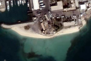
Written by Marco Ramerini The fort of Halat Bu Maher (also know as Qal’at Abu Mahir) is located on Muharraq island – the northernmost island of the archipelago – and was strategically situated to control both the straits between Bahrain and Muharraq, and the bay between Muharraq Town and Arad Fort. In 1630s. the Portuguese maps (“Livro das Plantas de ...
Read More »
Bahrain, Colonial Forts on Google Earth, Portuguese Colonialism
4,620 Views
Written by Marco Ramerini. Photos by João Sarmento. English text revision by Dietrich Köster. The Portuguese Fort of Qala’at al-Bahrain (Bahrain Fort), Bahrain. Remains of Qal’ At Al-Bahrain (16th century) or Portuguese Fort. The fort consists of three huge strongholds and the remnants of two towers in the middle and full walls linking the three strongholds together. It is surrounded ...
Read More »
Colonial Forts on Google Earth, Oman, Portuguese Colonialism
12,075 Views
Written by Marco Ramerini. Photos by Fritz Gosselck and João Sarmento. English text revision by Dietrich Köster. Oman is a country rich in fortifications, some of these were built along the Omani coast by the Portuguese in the sixteenth and seventeenth century, often altered from the original forms several forts built or modernized by the Portuguese are still visible today. ...
Read More »
Colonial Forts on Google Earth, Kenya, Portuguese Colonialism
18,044 Views
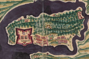
Written by Marco Ramerini. English text revision by Dietrich Köster. In 1498 the Portuguese explorer Vasco da Gama arrived in Mombasa on his route to India. Fort Jesus was built after the Portuguese had become masters of the East African coast for nearly a hundred years. During this time they had as main base an unfortified factory at Malindi. The ...
Read More »