Categories
Indonesia Moluccas Spanish Colonialism

The Spanish Presence in the Moluccas: Ternate and Tidore

Written by Marco Ramerini. English text revision by Geoffrey A. P. Groesbeck

The islands formerly known as the Moluccas – the Spice Islands – are five islands of volcanic origin (Ternate, Tidore, Moti, Makian, and Bacan). They are found off of the west coast of the island of Halmahera, in the Indonesian archipelago.

These islands were the only ones in the world where, at the time of the arrival of the Portuguese (c. 1510), cloves grew wild. Clove is an aromatic spice of the family Myrtaceae, whose botanical name is Caryophyllus Aromaticus (in full, Eugenia Caryophyllata, Syzygium Aromaticum).

This singular condition made the Moluccas islands famous since the ancient times. Clove was one of the most important trading commodities. It was traded in the Asian markets (i.e., Arabic-speaking countries, and China and India) and also the European ones. Its oil was used for the treatment of food as well as like essence to perfume the breath, and as an anesthetic for toothache.

The Moluccas had this key, lucrative commodity, but had to import most of their foodstuffs from other islands: sago and rice, for example, came from Halmahera, Ambon and Bacan. Cloves were exchanged for clothing, silk, porcelain, gold, silver, knives, glass, and other items.

All the Moluccas are dominated by high volcanoes, some of which are still active. Beyond the five main islands, there are also three smaller volcanic ones: Hiri to north of Ternate, Maitara between Ternate and Tidore, and Mare between Tidore and Moti.

Because of the continuous trade contacts between the Moluccas and Muslim merchants from Arabia and elsewhere in Asia, Islam made its entry in the islands around 1430-1460, with the conversion of various local kings. With the subsequent arrival of Christianity with the Portuguese, these two religions represented an important, “elitist” element, although the majority of the population still remained animist.

In 1512, when the Portuguese first arrived, two main kingdoms controlled the Moluccas: the Sultanate of Ternate, and the Kingdom of Tidore. Ternate one controlled, in addition to the island by the same name, half of the island of Moti; the northern side of the island of Halmahera (called by the Portuguese Moro); the island of Ambon; the east part of Ceram; and the northeast area of Sulawesi.

Tidore controlled, in addition to Tidore itself, the other half of the island of Moti; the island of Makian; the greater part of the island of Halmahera; and the western side of New Guinea. Control on these islands was exercised directly or through vassalage.

Two other smaller states also existed: Bacan and Jailolo. Bacan, whose main village was on the island of Kasiruta, extended its influence over the archipelago of Bacan and to the northern side of Ceram. Bacan was a great producer of sago, the basic food of the sparsely populated islands.

Jailolo in the past had been the more important of the two entities, but by the 1500s it was in decline and controlled only the northwestern side of Halmahera. Jailolo essentially was annexed by Ternate and the Portuguese in 1551.

In 1522, the sultan of Ternate make an alliance with the Portuguese, asking for and obtaining the construction of a Portuguese fortress on the island. The first stone of the fortress was laid on the feast day of Saint John the Baptiste, on 24 June 1522. Thus, the fort was called “São João Baptista de Ternate”. The alliance with the Portuguese tipped the balance in favor of Ternate in its struggles with Tidore. As a result, the king of Tidore asked in turn for the help of the Spaniards when Magellan’s expedition stopped at Tidore.

As is well known, starting with the Magellan expedition of 1521, the Spaniards tried several times to gain control of the “Spice Islands” to thwart the Portuguese, with whom they often nearly came to blows. The Spaniards established alliances with the sultans of Tidore and Jailolo, and Spanish troops were present in the islands during the years 1527-1534 and again between 1544-1545. However, the failure to discover a return passage through the Pacific prevented the Spanish from competing with the Portuguese as a naval power. Earlier, in 1529, in an attempt to defuse the situation, an agreement was reached between Spain and Portugal, the Treaty of Saragozza. Under the terms of this treaty, the king of Spain had at least nominally abandoned the right for a Spanish presence on the islands in exchange for a sum of money.

The first period of Spanish interest in the Moluccas was characterized by fights against the Portuguese for the control of the islands. It began with the arrival of the Magellan expedition, and ended in 1545 with the surrender to the Portuguese by Villalobos’ army. Between these two expeditions, the Spaniards had sent other fleets, including those of Loaisa (1527) and Saavedra (1528), in addition to the unlucky expedition of Grijalva (1538). The expedition of Villalobos was launched after the Treaty of Saragozza; thus it was directed to seek commerce with unspecified islands, in other words, those not occupied by Portugal. The center of activity for the Spaniards remained for the whole period the island of Tidore.

This first period of interest for the Spaniards in the Moluccas, covering the years 1521-1606, can be divided into two distinct parts: the first part was that above, characterized by fights against the Portuguese for control of the islands, beginning with the arrival of Magellan’s expedition in 1521 and ending in 1545 with the surrender to the Portuguese of the men of Villalobos.

Moluccas 1714.
Moluccas 1714.

The second part of this first period took place during the union between the crowns of Spain and Portugal. At this time, Spanish expeditions departed from Manila in the Philippines and were organized with the aim of helping Portuguese troops defeat their Ternate enemies, who were rebelling against Portuguese control, and who had managed to expel them from the island. The main objective of these expeditions was the “reconquista” of the Portuguese fortress of Ternate. None of six successive Spanish attempts reached this objective, however.

These attempts began in 1582 with the expedition of Francisco Dueñas. This first expedition was only an information-gathering exercise, designed to learn more about the military situation on the islands. Francisco Dueñas remained in the Moluccas for approximately two months between March and April of 1582. The next expedition was that commanded by Juan Ronquillo, between 1582 and 1583, in which the Spaniards collaborated with the Portuguese in some punitive expeditions. In 1584, Pedro Sarmiento went, and then in 1585 Juan de Morón as well. Neither of these two expeditions had the hoped-for result: the fortress of Ternate was attacked, but without result. A larger and better assembled army left Manila in 1593 under the command of the governor of the Philippines, Gómez Pérez Dasmariñas. A rebellion and the murder of Dasmariñas before reaching the Moluccas cancelled the operation. The final Spanish expedition of this period was that sent from Manila to aid the fleet of the Portuguese admiral André Furtado de Mendonça. The Spanish assistance was commanded by Juan Juárez Gallinato, and left Manila at the end of 1602. A combined Spanish-Portuguese attack against the fortress of Ternate yielded no success.

What was instead successful was the attack by the Dutch on the fortress of Tidore in 1605. It was conquered on 19 May 1605. But without a sufficient number of men to garrison the conquered fort, the Dutch commander, vice admiral Cornelis Bastiaensz, was limited to leaving just a few men stationed at a small trading post. A Spanish response to the sudden Dutch presence was not late in arriving. In 1606, an expedition led by the governor of the Philippines, Pedro de Acuña, reestablished Iberian control on the Moluccas.

After his rapid victory, Acuña deported to Manila the sultan of Ternate, Said Barakat, with his son the prince, and all his dignitaries, in total about thirty persons. The Spanish remained on Ternate for 57 years, from 1606 until 1663 (although on the island of Siau, a very small Spanish garrison remained from 1671 to 1677). The Spanish also occupied a few smaller spice islands as well.

This period was characterized by continuous fighting against the Dutch, who nearly always had the upper hand at sea and better arms as well as more soldiers and ships. For most of the period the Spaniards had a faithful ally in the sultan of Tidore, while the Dutch had the same in that of Ternate.

After the conquest of Ternate in 1606, the Spaniards were nominally masters of the Spice Islands. However, they did not succeed overall, in contrast to the Dutch, who returned again and formed an alliance with the rebels on Ternate. In fact, the Spanish presence was mainly a military one thanks to the intransigent hostility of the Ternate rebels and the tenacious Dutch, who were more battle-trained in any case.

Starting from the year 1607, the Dutch extended their control over the more profitable and desirable part of the Moluccas. In 1607 they constructed a fort on the same island of Ternate just a few kilometers from the Spanish city. It was first known as Fort Malayo and later Fort Orange (Benteng Orange, in the city of Ternate). On the same island in October 1609, the Dutch built a fort at Tacome (Fort Willemstadt). The fort of Tacome was situated in the northern side of the island, in an area rich of cloves. A third fort also was constructed, in 1612, at Tolucco (Fort Hollandia). The main Dutch base in the Moluccas remained, however, Fort Malayo. In a few years, practically the greater part of the island of Ternate had been lost to Spanish control. Great aid was rendered to the Dutch from their natural allies on Ternate. In the same years when these forts on Ternate were built, Dutch control was extended also to the other islands of the archipelago. From 1608, the island of Makian also was occupied by the Dutch, who constructed three fortresses along the coasts of the island. Makian was the richest island in the area, and very much desired by the Dutch, who aimed to control its commerce in spices. Another fortress, Fort Nassau, was built in 1609 on the island of Moti (Motir), situated between Tidore and Maquiem (Machian). This island also was rich in cloves. Also in 1609, the Spanish fort of Bachan was captured by the Dutch commander, Vice Admiral Simon Jansz Hoen.

After 1606, and between 1607 and 1610, the Dutch with their native allies succeeded in putting the Spanish on the defensive and took control of the greater part of the islands. Under Spanish control remained only the southern side of the island of Ternate (with its main town of “Nuestra Señora del Rosario”); the entire island of Tidore; and some ports on the islands of Halmahera and Morotai. The Spanish garrisons had their headquarters in the islands of Ternate and Tidore. It is often difficult to understand by the documents where they were situated. The Spanish “presidios”, were sometimes called by different names, causing not a little difficulty in understanding which was which.

In addition to several fortified places on Ternate and Tidore, the Spanish from time to time sporadically maintained garrisons also on the peripheral islands of Halmahera, Morotai and Sulawesi. These were strategic locations for maintaining garrisons. The islands were sources of sago and other indispensable food for the maintenance of the garrisons and the population of the islands of Ternate and Tidore, two islands where difficult terrain and constant state of war did not allow the cultivation of such products. The Spanish garrisons depended on restocking of their food, clothing and ammunition supplies almost exclusively from the so-called fleet of “soccorro” that was sent every year from the Philippines. If one of these fleets was late, or worse still, was captured by the Dutch or shipwrecked in bad weather, there ensued enormous want on the part of both the Spanish soldiers of the garrisons and the population of the city of Ternate.

In spite of these deprivations and the high human and material cost, the Spanish maintained garrisons in Ternate, Tidore and other islands until 1663, when the governor of the Philippines, Manrique de Lara, decreed the dismantling and abandonment of all the garrisons of the Moluccas.

The Spanish town of Ternate: Ciudad del Rosario.

Extract from my studies: “The Spanish presence in the Moluccas, 1606-1663/1671-1677” and “Le fortezze Spagnole nell’Isola di Tidore, 1521-1663” (“The Spanish fortresses in Tidore Island 1521-1663, Moluccas, Indonesia“).

[divider]

[divider]

BIBLIOGRAPHY:

– Various Authors “Correspondencia de D. Jeronimo de Silva con Felipe III, D. Juan de Silva, el Rey de Tidore y otros personajes, desde abril 1612 hasta febrero de 1617, sobre el estado de las islas Molucas” In: “Coleccion de documentos ineditos para la historia de Espana” vol. n° 52, pp. 5-439, 1868. Madrid.

– Argensola, Bartolomé Leonardo “Conquista de las islas Malucas” 372 pp. Ediciones Polifemo, 1992 (1609), Madrid, Spain. English edition: “The discovery and conquest of the Molucco and Philippine Islands” 260 pp. ills. 1708, London, UK. French edition: “Histoire de la conquete des isles Moloques par les espagnols, par les portugais, et par les hollandois. Amsterdam 1706” Sabin, 1947

– Belen Banas Llanos, Maria “Las islas de las especias. Fuentes etnohistoricas sobre las Molucas XIV-XX” 160 pp. Universidad de Extremadura, 2000, Caceres, Spain.

– Blair, Emma Helen & Robertson, James A. “The Philippine Islands 1493 – 1898” CD-Rom BPI Foundation Inc., 2001, Manila, Philippines.

– Colin, F. “Labor Evangelica” 3 vols. 1900-1903, Barcelona. Vol. I pp. xix+239+636 Vol. II pp. 725 Vol. III pp. 831

– Noguera, P. H. “Guia de fuentes manuscritas para la historia de Filipinas conservadas en Espana” Fundacion Historica Tavera, 1998, Madrid

– Pastells, P. “Historia General de Filipinas” Tomo V, VI, VII Barcelona, Spagna.

– Prieto Lucena, A. M. “Filipinas durante el gobierno de Manrique de Lara, 1653-1663” xiv+163 pp. Escuela de Estudios Hispano-Americanos de Sevilla, 1984, Sevilla, Spagna.

– Ramerini, Marco “Le Fortezze Spagnole nell’Isola di Tidore 1521-1663” Firenze, 2008

– Van der Wall, V. I. “De Nederlandsche oudheden in de Molukken” xx, 313 pp. with 3 folding maps and 155 illustrations on 93 plates. 1928, ‘s Grav., NL. pp. 227-275 Description of the 16th and 17th century Dutch, Portuguese and Spanish fortresses, graves, inscriptions and other monuments on the Moluccas. The monuments are described in their historical context, with emphasis on the history of the VOC.

– Wessels, C. “De Katholieke Missie in het Sultanaat Batjan (Molukken) 1557-1609” ? In: “Historisch Tijdschrift, year 8” 427 pp. 1929, Tilburg, NL. First attempt of a description of Portuguese & Spanish roman-catholic missionary progress in the Sultanate of Batjan (Moluccas).

– Wessels, C. “De Augustijnen in de Molukken, 1544-1546; 1606-1625” In: “Historisch Tijdschrift” n°13 pp. 44-59 Bergmans & Cie, 1934, Tilburg

– Wessels, C. “De katholieke missie in de Molukken, Noord-Celebes en de Sangihe-Eilanden gedurende de spaansche bestuursoeriode 1606-1677” 141 pp. Drukkerij Henri Bergmans & Cie, 1935, Tilburg, NL.

Categories
Dutch Colonialism Indonesia Malaysia Moluccas Philippines Spanish Colonialism

The abortive expedition of Don Juan de Silva against the Dutch in the East Indies (1612-1616)

Written by Marco Ramerini. English text revision by Dietrich Köster.

English translation of a small part of my work entitled “La presenza Spagnola alle Isole Molucche, 1606-1663”.

In the propositions of the governor of the Philippines, Don Juan de Silva, a big joint expedition of Spaniards and Portuguese should succeed in getting rid of the Dutch forces present in Indonesian islands one time for all. The Dutch feared also such expedition (“Generale Missiven” vol. I pp. 37-38). In 1612 in order to agree with the viceroy of Portuguese India, de Silva had sent to India the former governor of Ternate Cristobal de Azcueta, but the entire expedition disappeared in a shipwreck between Manila and Macau.

The governor of the Philippines did not loose his courage and charged this time 2 Jesuits to reach Goa, father Pedro Gomes, rector of the Company in Ternate and father Juan de Ribera, head of the Manila college. At the end of 1614 ( Ribera left in november 21th Cavite harbour) they went with 2 different fleets to Goa, where they arrived in 1615 without problems . The agreement, which the 2 fathers reached with the viceroy, required the Portuguese to contribute with 4 big galleons, which would be sent to Malacca.

Father Pedro Gomez returned to Manila in July 1615 to inform the governor of the results of the mission and to tell him that the 4 galleons would soon sail to the Philipines. De Silva had prepared a big fleet. In order to obtain the artillery for this expedition he had weakened the defences of the city of Manila with grave risks in case of an attack on the city by the Dutch.

When the Portuquese galleons did not arrive, he thought of going at their encounter. Notwithstanding the negative advice of many of his subordinates he decided to depart in February 1616 to Malacca instead of sailing directly to the Moluccas. It seemed that Jeronimo de Silva had concluded treaties with the inhabitants of the Makian and Moti islands and that upon arrival of the great expedition the islanders would rebel against the Dutch and help the Spaniards. [1]

The governor suffered of bad health. It seemed that the illness manifested itself already for the first time before the departure from Manila. There are testimonies of the fluctuating health of the governor since the first expedition to the Moluccas in 1611. Several times he had already sent petitions to the King to be replaced in his function to be able to return home.

In spite of this the governor of the Philippines sailed from Manila on 9 February 1616 at the head of an important expedition composed of 10 big galleons, 4 galleys, a patach and other minor vessels. The galleons were: the ship of the General-Staff “Salvatore” of 2,000 (volumetric) tons, the flagship “San Marcos” of 1,700 tons, the 2 galleons “San Juan Bautista” and “Espiritu Santo” both of 1,300 tons, further the smaller galleons “San Miguel” (800 tons, “San Felipe” (800 t.) , “Nuestra Señora de Guadalupe” (700 t.), “Santiago” (700 t.), “San Andrés” (500 t.), “San Lorenzo” (400 t.). On this fleet had embarked 5,000 men, both soldiers and sailors, of which less than 2,000 Spaniards, a unit of Japanese infantry and about 300 pieces of artillery. Six Jesuits took also part in the expedition.

The fleet was the mayor armada, which these islands had ever seen. So marvelous that father Colin asked himself , “how was it possible to build such machines in these recently conquered countries populated with Spaniards, the most remote and distant part of the entire monarchy”. The fleet took the direction of the Strait of Malacca with the intention to unite forces with a Portuguese armada and to attack together first of all the Dutch factory on Java and thereafter the Dutch bases on the islands of the Moluccas.

But the Portuguese fleet sent by the viceroy of Goa had already been completely destroyed near Malacca, attacked by Dutch vessels. In order to avoid the capture of the big galleons by the Dutch the Portuguese were forced to burn them.

The Spanish armada entered the Strait of Singapore on February 25th, 1616. From there de Silva sent Juan Gutierrez Paramo to Ternate with a “socorro” (relief fleet) with the new title of sergeant-mayor.[2] Probably Juan de la Umbria was sent to Ternate together with Paramo.[3] The health condition of de Silva deteriorated and on April 19th 1616, the eleventh day of his suffering, he died in the city of Malacca. The whole entreprise ended up in a gigantic fiasco. Nothing had been done against the Dutch and the death of de Silva in Malacca shortly after his arrival. It was the inglorious end of this expedition.

The armada returned to Manila at the beginning of June 1616.[4] Caused by fever and other ilnesses that struck the fleet crews during their stay in Malacca and the Strait of Singapore, a large part of the men of the fleet died and the vessels returned to Manila “sin gente” (without people). [5])

The decision of de Silva to go first to Malacca instead of pointing directly to the Moluccas is a bit strange, considering that according to the treaty the Portuguese galleons should have sailed to the Philippines in order to join the Spanish fleet. Besides this, at the moment of departure of de Silva from Manila the Portuguese fleet should have arrived in time, if they had not been intercepted by the Dutch. Strange enough was that de Silva wanted in any case try to unite his own force with that of the Portuguese, although he had at his command a big and important naval force and the position of the Dutch in the Moluccas was very precarious as various testimonies inform us. “The enemy is meager in this season”. Secondly, Vergara was certain that a large part of the islands would have been captured by the Spaniards, if the Spanish fleet would not have waited and have sailed directly to the Moluccas without passing via Malacca.[5]

The Spanish town of Ternate: Ciudad del Rosario.

The Spanish fortresses on Tidore Island 1521-1663, Moluccas, Indonesia.

NOTES:

[1] Correspondencia””, Jeronimo de Silva, pp. 284-285
[2] AGI: “Confirmación de encomienda de Filipinas. Juan Gutierrez Paramo. 10-03-1625”, Filipinas,48,N.1
[3] AGI: “Confirmación de encomienda de Marinduque, etc. Juan de la Umbria. 02-10-1623”, Filipinas,47,N.60
[4] For further information about this expedition see: (Colin-Pastells “Labor Evangelica” vol. III pp. 581-646)
[5] AGI: “Carta de Lucas de Vergara Gaviria al Rey defensa Maluco. Terrenate, 31 May 1619” Patronato, 47, R. 37

AGI= Archivo General de Indias/ General Archives of the Indies; Sevilla, Spain

Categories
Indonesia Portuguese Colonialism

Ambon: The Portuguese in the Moluccas, Indonesia

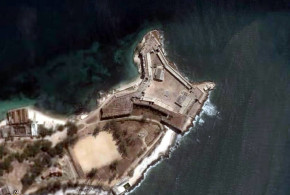
Written by Marco Ramerini. English text revision by Dietrich Köster.

Ambon is an island located in the south of the Spice Islands in what is today the Indonesian archipelago.

In the year 1569 the Portuguese Gonçalo Pereira Marramaque erected a wooden fort on the northern coast of the Ambon island. In 1572 the fort was moved to the southern side of the bay. Subsequently Sancho de Vasconcelos built a temporary fort at Gelala and another at Batumarah, both of wood; and finally he built a stone fortress, where the town of Ambon is situated today.

The first stone was laid on 25 March 1576 and the fortress was named “Nossa Senhora da Anunciada”. In July 1576 the new fortress was inaugurated. Inside the square-sized construction crowned with four towers, one at each corner, there were the captain’s residence, a meeting room, some storehouses and dwellings for the military officials.

The town was built around the fortress and was divided into several quarters, all inhabited by Christians. The Portuguese town was not walled, only the Jesuits (in Ambon since 1578) had a stone wall around their garden to protect themselves against attacks of enemy villages. Near their residence was the church of “Sant’ Iago” (1581) covered by a thatched roof.

The Jesuits also cared for the church of São Tomé (1581). They used their residence in Ambon like a pastoral center for Ambon and the three Lease Islands: Haruku, Saparua, Nusalaut. The Ambon residence was for some years (1575-1578) the center of the Moluccas Jesuit mission.

Along the shore was situated the oldest church of Ambon called “São Paulo”, a fortress church. Near the southeastern side of the fort were the hospital and the “Igreja da Misericórdia”. This brotherhood “Confraria da Misericórdia” was founded in 1579.

The town of Ambon was besieged many times. Its history is a history of war. In 1591 and in 1593 it was besieged by the Ternatans; in 1598 by the Javanese; in 1600 by the Dutch; finally on 23 February 1605 the Portuguese fortress surrendered to the Dutch.

BIBLIOGRAPHY:

– Jacobs, Hubert “The Portuguese town of Ambon, 1567-1605” In: Various Authors “II Seminário Internacional de História Indo–Portuguesa” 601-614 pp. IICT & CEHCA 1985 Lisbon, Portugal.

– Jacobs, Hubert “Documenta Malucensia” Vol. I-II-III Vol. I 1542-1577. XLII-84*-760 pp. (vol. 109). Monumenta Historica Societatis Iesu, 1974, Roma, Italia. Vol. II 1577-1605. XXXII-65*-794 pp. (vol. 119). Monumenta Historica Societatis Iesu, 1980, Roma, Italia. Vol. III 1606-1682. XXIV-54*-778 pp. (vol. 126). Monumenta Historica Societatis Iesu, 1984, Roma, Italia.

Categories
Indonesia Moluccas Portuguese Colonialism

The Portuguese fort of Ternate

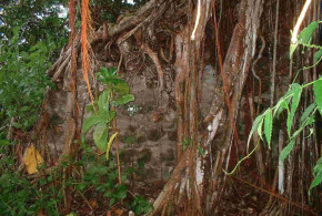
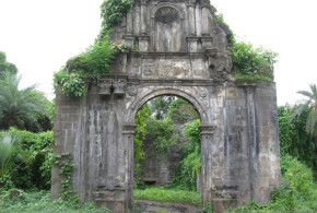
Written by Marco Ramerini. English text revision by Dietrich Köster.

The Portuguese fort of Ternate was founded by António de Brito in 1522, the foundation stone of the fortress was laid the day of the feast of St. John the Baptist, June 24, 1522, the fort was named “São João Bautista de Ternate.” The outer wall of the fortress enclosing a space of 26 or 27 Portuguese square fathoms, the wall measured 1 arm of thickness and the tower of the fort measured 5 fathoms or 40 palms and was a two-storey building. 1 The fortress was built by the Portuguese on the spot, where the principal city of the Sultanate of Ternate (south-west of the island) used to be, a league from the island’s main port, called Talangame, where the ships anchored. 2

This is the description of the construction of the fort made ​​by Gaspar Correia: …mandou o capitão abrir os alicerces, e elle com toda a gente, sendo dia do bemauenturado são João Bautista, vinte e cinco (The day is June 24) dias de julho de 522, foi dita sua missa solene, festejada com muita artilharia dos navios,...” “E foi a primeira huma torre quadrada afastada do mar um jogo de bola, e de ahy correo o muro atrauessando pera a terra espaço de trinta braças, de onde tornou a voltar, fazendo quadra, outras trinta braças, em que se fez outra tal torre, e de ahy voltou à praia, onde fez outro canto, e correu o muro ao longo da praia a çarrar (=encerrar) na primeyra torre, junto da qual fiqou a porta de longo da praia, com sua gorita (=guarita). Assy (=assim) que a obra se foy fazendo com estas duas torres sómente, que depois nas quinas das quadras se fizeram outras taes torres, e no meo (=meio) se fez a torre da menagem grande, e no primeiro sobrado varandas para todas partes, e no sobrado de cyma suas guaritas, e fortemente madeirado, d’onde podiam tirar falcões;… 3

In 1526 three years after the work started António de Brito gave the command of the fortress of Ternate to Garcia Henriques. The work of the fortress was far from being complete, in fact Castanheda informs us that on the side that looked at the sea the wall had not yet been completed, while on the side which faced the mountain only two ramparts were built, one only 2 fathoms high and the other “não tinha feyto mais que os alicerces“. The tower “da managê” was high “xl palmos cõ dous sobrados, & do derradeyro até ho telhado sem paredes se não cõ caniçadas de canas fédidas forradas desteiras, & disto erão feytos os repartimentos das camaras“, also of the same material of the walls were made ​​the Feitoria, where owing to the incompleteness of the work the pigs and goats could move freely. 4

In 1537 at the time of the Portuguese Governor António Galvão the city of Ternate had a population of 123 Portuguese and with their wives, their children, their slaves and servants the total number reached 1,600 people. 5 In front of the Portuguese fort was a coral reef, which made it difficult to accede the ships. It had three passes, the first was called “Lymatao“, it was located to the south at the end of the town “dos mouros”, the channel in the center was called “barra d’arvore“, because it was located in front of a high tree and the last channel called “barra da Nossa Senhora“, located at the eastern end of the Portuguese city, about 200 fathoms (about 440 m.) from the fort in front of the chapel dedicated to “Santa Maria“. During the government of António Galvão the Central and Southern channels were closed with stones, whereas the “barra da Nossa Senhora” was made ​​more navigable, measuring two fathoms (4.40 m.) in depth.  6

In 1537 Galvão began the construction around the Portuguese city of walls, mud walls, moats and ramparts. The Feitoria was surrounded by mud walls, and inside were also built some warehouses to store the cloves. It was founded a “Casa da Misericórdia“, a water mill, which received water from three leagues away (between 12 km and 18 km) through pipes. Finally ​​a feeble attempt was made to cultivate rice, vegetables and cereals, in the area around the town the breeding was also started and finally a small school for the children of prominent indigenous people and the Portuguese was founded. 7

Another interesting description of the Portuguese fort and the city is given by the “Livro das cidades e fortalezas que a coroa de Portugal tem nas partes da Índia …” written in 1582: the fortress was situated south of the city of the Sultan, along the sea, to a “tiro de espera” from the city “dos Mouros“, the conformation of the land between the fortress and the indigenous city prevented the view between the two. To the south of the fortress was developing a rather large city inhabited by Portuguese casados ​​and indigenous Christians, this was surrounded by a wall “de taipa muito forte“. The harbor in front of the castle is described as a poor port, because the barrier of rock and coral that prevents the larger vessels (“que demandem mais altura que duas braças de agoa“) the passage. Between the mountains and the island fortress on a “outeiro alto“, the Portuguese had built a bastion, where they had placed some pieces of artillery.  8

In 1606 the Spaniards took the control of Ternate; they settled, where the old Portuguese fort used to be.

The Spanish town of Ternate: Ciudad del Rosario.

[divider]

[divider]

NOTES:

1 Jacobs, H. “A treatise on the Moluccas (c. 1544)” p. 211

2 Jacobs, H. “A treatise on the Moluccas (c. 1544)” p. 235

3 Gaspar Correia “Lendas da India”, vol. II pp. 714-715

4 Fernão Lopes de Castanheda “História do descobrimento e conquista da Índia pelos portugueses” Livro VI, cap. 128, pp. 358-359. See also: Gaspar Correa “Lendas da India” vol. II p. 996

5 Jacobs, H. “A treatise on the Moluccas (c. 1544)” p. 287

6 Jacobs, H. “A treatise on the Moluccas (c. 1544)” p. 289-291

7 Jacobs, H. “A treatise on the Moluccas (c. 1544)” p. 293-299)

8 “Livro das cidades e fortalezas que a coroa de Portugal tem nas partes da Índia …” foglio 64v. This “outeiro alto” could be the same place where the Spaniards built the Fuerza Nueva fortress.

Categories
Indonesia Portuguese Colonialism

Makassar and the Portuguese

Written by Marco Ramerini. English text revision by Dietrich Köster.

The Kingdom of Makassar at the time of Portuguese expansion in the Asian seas comprised the two Kingdoms of Gowa and Tallo. Portuguese merchants frequented Makassar intermittently during the 16th century, but it was only after the Islamization of the Makassar Kingdom (1600s), that their presence grew.

During the 17th century the Portuguese used Makassar as a commercial center for silk, cloves, textiles, sandalwood and diamonds. In the 1620s regularly there were as many as 500 Portuguese merchants, who frequented the port of Makassar. They traded here in safety and the Sultans were fluent in Portuguese and gave aid and comfort to them. The friendly relations between Makassar and Portugal were strenghtened by their common attempts to stop the Dutch power in the Moluccas and Sunda islands.

The prosperity of Makassar greatly increased after the fall of Malacca into Dutch hands (1641), when many Portuguese merchants emigrated to Makassar. In the 1650s the Dominicans founded a church in Makassar. In 1660 there were about 2.000 Portuguese residents in the town. They lived in their own residential area called Portuguese quarter.

In June 1660 a strong Dutch fleet comprising 31 ships and 2.600 men attacked Makassar and stormed the fort of Panakkukang in the port. The main Dutch aim for this attack was to expel the Portuguese from Makassar. A treaty between the Dutch and the Makassars was signed and finally ratified on 2 December 1660. The terms were: The Portuguese should be expelled from Makassar within a year.

The Portuguese departure would have been the complete ruin of the Kingdom. For this reason the Sultan openly attempted to delay their departure. The terms of the treaty were not respected and the Portuguese stayed in Makassar for several years more, but slowly they went to Flores (Larantuka), Solor, Macau, Timor, Siam or Batavia. Finally in 1665 the last Portuguese merchants were forced to leave due to the Dutch pressure.

BIBLIOGRAPHY

– Borges, Maria do Carmo Mira, “Os portugueses e o sultanato de Macassar no século XVII” 269 pp., Tese Mestrado História dos Descobrimentos e da Expansão Portuguesa, Universidade Nova de Lisboa, 1996, Lisbon.

– Jacobs, Hubert “Jesuit Makasar Documents, 1612-1682” XXIII-36*-284 pp. (vol. 134). Monumenta Historica Societatis Iesu, 1988, Rome, Italy.

– Jacobs, Hubert, “The first locally demonstrable Christianity in Celebes 1544”, in: STUDIA N° 17, pp. 251 – 305, 1966, Lisbon, Portugal.

Categories
Indonesia Portuguese Colonialism

Portuguese Fort in Ende Island, Indonesia

Written by Marco Ramerini.

In 1595, the Dominican friars led by Brother Simone Pacheco built a little Fort on the island of Ende Minor (Palau Ende) to protect local Christians from Islamic attacks. This small fort was named by the Portuguese as Fortaleza de Ende. Pero Carvalhais was its first captain. Within the walls of the fort was built the church of São Domingos. Other churches were built in the two neighboring villages of Currolalas (Church of Santa Catarina de Siena) and Charaboro (Church of Santa Maria Madalena).

Written by Mark Schellekens. Photos by Mark Schellekens and Greg Wyncoll. English text revision by Dietrich Köster.

The ruins of the Portuguese fort on Ende island (Ende Minor) are nothing more then a collection of coral rocks. Just a single wall remains standing up and for the rest there are some floor parts and foundations visible.

The site is used nowadays by local farmers to farm Tapioca and corn and little remains as most of the stones from the fort have been used to build houses in the village of Kemo (pronounced as “K’mo”).

This village is easily reached from mainland Flores, from the town of Ende from where 4-5 boats daily sail to Kemo, where the ruins are located.

[divider]

[divider]

BIBLIOGRAPHY:

– Jacobs, Hubert “Documenta Malucensia”, Vol. II 1577-1605. XXXII-65*-794 pp. (vol. 119), Monumenta Historica Societatis Iesu, 1980, Rome, Italy.

– Leitão, Humberto, “Os Portugueses em Solor e Timor de 1515 a 1702”, 302 pp., Tipografia Liga dos Combatentes da Grande Guerra, 1948, Lisbon, Portugal. An old work, but one of the few about this subject; interesting.

– Matos, A. T. de, “Timor Português 1515-1796: contribuição para a sua história”, 489 pp., map, Instituto Histórico Infante Dom Henrique, 1974, Lisbon, Portugal. The main book on early Timor history.

– Sá, Artur Basílio de, “Documentação para a história das missões do Padroado Português do Oriente: Insulíndia” Vol. VI (1595-1599) xxi+432 pp., IICT Centro de Estudos de História e Cartografia Antiga, 1988, Lisbon.

– Villiers, J., “As derradeiras do mundo: The Dominican Mission and the Sandalwood trade in the Lesser Sunda Islands in the sixteenth and seventeenth century”, in: Various Authors, “II Seminário Internacional de História Indo–Portuguesa”, pp. 572-600, IICT & CEHCA, 1985, Lisbon, Portugal.

Categories
Danish Colonialism India

Tranquebar: a Danish fort in India

Written by Marco Ramerini.

Tranquebar (Tharangambadi) is a small village in Tamil Nadu in India located on the Coromandel coast about 30 km north of Nagapattinam. Tranquebar has the distinction of have been a Danish colony between 1620 and 1845. The Danes in 1620 founded the Fort Dansborg and made ​​it their main trading settlement along the Indian coast.

Tranquebar (Dansborg castle):

  • Danish: 1620-May 1801
  • English: (May 1801-Aug. 1802)
  • Danish: Aug. 1802-1808
  • English: (1808-20 Sep. 1815)
  • Danish: 20 Sep. 1815-7 Nov. 1845
  • English: (7 Nov. 1845- 1947)

[divider]

[divider]

BIBLIOGRAPHY:

– Barner Jensen, Uno “Danish East India trade coins and the coins of Tranquebar 1620-1845” 48 pp. Uno Barner Jensen 1997 Brovst, Denmark. A complete study on the Danish coins of Tranquebar.

– Brijraj Singh “The First Protestant Missionary to India Bartholomaeus Ziegenbalg (1683-1719)” 195 pp. 1999, Contents: 1. Introduction. 2. Ziegenbalg’s life. 3. Tranquebar. 4. Ziegenbalg and language. 5. Ziegenbalg, educator. 6. Ziegenbalg and Hinduism. 7. Ziegenbalg in inter-faith dialogue. 8. The missionary enterprise and colonialism; or, was Ziegenbalg a colonialist? Appendix: 1. Partial checklist of Ziegenbalg’s works: prepared from secondary sources. 2. Tamil: texts mentioned in the genealogy of the South-Indian Gods. Works cited. Index. By focusing upon aspects of the life and work of Bartholomaeus Ziegenbalg, the first protestant missionary to India, this book offers an insight into a little-known corner of South India’s cultural history. The author reflects on the nature of south Indian society when Ziegenbalg arrived there and the way and extent to which his work changed it.

– Feldbaek, O. “India trade under the Danish flag 1772-1808” 359 pp. Monograph Series n° 2 Scandinavian Institute of Asian Studies 1969

– Feldbaek, O. “The Danish Asia trade, 1620-1807: value and volume” In: “An Expanding World” Vol. n° 10; Prakash, Om “European commercial expansion in early modern Asia” pp. 293-317 Also in: “The Scandinavian Economic History review” Vol. 39, n° 1 Odense, 1991, pp. 3-27

– Fenger “History of Tranquebar Mission” 1863, London, UK. – Glamman, K. “The Danish East India Company” In: “Actes du 8ème Colloque Intern. d’Histoire Maritime” 1966, Beirut, Lebanon.

– Gray, J. C. F. “Tranquebar: A Guide to the Coins of Danish India, Circa 1620 to 1845” 83 pp. Quarterman Publications Incorporated, 1974

– Rasmussen, Peter Ravn “Tranquebar: the Danish East India Company 1616-1669” Internet article Peter Ravn Rasmussen, 1996, Denmark.

– Subrahmanyam, S. “The Coromandel Trade of the Danish East India Company, 1618-1649” Scandinavian Economic History Review, Vol. XXXVII, No. 1, 1989. pp. 41-56

Categories
India Portuguese Colonialism

Population of the Portuguese Settlements in India

Written by Marco Ramerini. English text revision by Dietrich Köster.

Diu: (20°43’N – 71°00’E)

Damão Grande or Praça de Damão (Damão, Moti Daman or Daman): (20°25’N – 72°50’E)

1634: 400 “almas entre portugueses e nativos cristãos”. Source: Leão “A Província do Norte do Estado da Índia”

1662: 100 “casais portugueses”. Source: Leão “A Província do Norte do Estado da Índia”

Bassein or Baçaim (Vasai): (19°20’N – 72°49’E)

1634: 400 “casados brancos”, 200 “pretos cristãos” and 1.800 slaves in the town, “fora dos muros” there were 250/300 “casados brancos” and 2.000 “nativos”. Source: Leão “A Província do Norte do Estado da Índia”

1662: 5.000 “homens de armas”. Source: Leão “A Província do Norte do Estado da Índia”

1720: the Province of Baçaim numbered 890 “europeus”, 58.131 “cristãos”. Source: Leão “A Província do Norte do Estado da Índia”

Tana:

1634: 80 “casas de brancos” and 100 “casas de pretos”. Source: Leão “A Província do Norte do Estado da Índia”

Bombaim:

1634: 12 “casados portugueses” and 50 “pretos”. Source: Leão “A Província do Norte do Estado da Índia”

Old Map of Bassein (Vasai)

Chaul:

1634: 200 “casados portugueses” and 50 “pretos cristãos”. Source: Leão “A Província do Norte do Estado da Índia”

1666: 21 “chefes de família portugueses”. Source: Boxer “O Império colonial português 1415-1825”

Goa:

1550: 2.000 “casados”. Source: Disney “Twilight of the pepper Empire”

1630: 800 “casados”. Source: Disney “Twilight of the pepper Empire”

16th – 17th centuries between 1.000/2.000 and 4.000/5.000 “soldados”. Source: Disney “Twilight of the pepper Empire”

1666: 320 “chefes de família portugueses”. Source: Boxer “O Império colonial português 1415-1825”

1866: 2.240 “descendentes” or “mestiços”. Source: Boxer “O Império colonial português 1415-1825”

1871: 2.500 “descendentes” or “mestiços”. Source: Boxer “Relaçoes raciais no Império colonial português”

1956: 1.100 “descendentes” or “mestiços”. Source: Boxer “Relações raciais no Império colonial português”

Onor (Honawar): (14°17’N – 74°26’E)

1634: 30 “casados”. Source: Disney “Twilight of the pepper Empire”

Barcelor or Braçalor (Basrur): (13°38’N – 74°44’E)

1634: 30 “casados” and 35 “soldados casados”. Source: Disney “Twilight of the pepper Empire”

Mangalore (Mangalor): (12°54’N – 74°50’E)

1634: 35 “casados”. Source: Disney “Twilight of the pepper Empire”

Cannanore: (11°51’N – 75°22’E)

1630s: 40 “casados”. Source: Disney “Twilight of the pepper Empire”

Cranganore (Kodungallor): (10°13’N – 76°13’E)

1630s: 40 “casados” and 100 “soldados”. Source: Disney “Twilight of the pepper Empire”

[divider]

[divider]

Cochim. From Livro das Plantas de Todas as Fortalezas (1635). Author Bocarro. No Copyright
Cochim. From Livro das Plantas de Todas as Fortalezas (1635). Author Bocarro

Cochin, Cochin de Baixo or Santa Cruz: (09°57’N – 76°15’E)

1630s: 500 “casados” (of whom 300 Portuguese and 200 Indian Christians). Source: Disney “Twilight of the pepper Empire”

Coulão (Quilon): (08°53’N – 76°35’E)

1630s: 60 “casados”. Source: Disney “Twilight of the pepper Empire”

Tuticorin or Tutucorim: (08°48’N – 78°09’E)

1640: pequena povoação de “casados”. Source: Subrahmanyam “Improvising Empire – Portuguese trade and settlements in the Bay of Bengal 1500 – 1700” or “Comércio e conflito – A presença portuguesa no Golfo de Bengala 1500 – 1700”

Nagapatao or Negapatao (Negapatam or Nagapattinam): (10°47’N – 79°50’E)

1533: 30 “fogos”, 1540: 100 “fogos”, 1630: 500 “fogos”.Source: Subrahmanyam “Improvising Empire – Portuguese trade and settlements in the Bay of Bengal 1500 – 1700” or “Comércio e conflito – A presença portuguesa no Golfo de Bengala 1500 – 1700”

1577: 60 “casados”, 200 “eurasiáticos”, 3000 Indian Christians. Source: Diffie-Winius “Foundation of the Portuguese Empire 1415-1580”

Porto Novo (Parangi-Pettai): (11°29’N – 79°46’E)

São Tomé de Meliapor: (13°00’N – 80°15’E)

1530: 40 “casados”, 1545: 100 “famílias”. Source: Subrahmanyam “Improvising Empire – Portuguese trade and settlements in the Bay of Bengal 1500 – 1700” or “Comércio e conflito – A presença portuguesa no Golfo de Bengala 1500 – 1700”

1600: 600 “casados”, from 1610s. in decline. Source: Subrahmanyam “Improvising Empire – Portuguese trade and settlements in the Bay of Bengal 1500 – 1700” or “Comércio e conflito – A presença portuguesa no Golfo de Bengala 1500 – 1700”

1537: 50 “casados”. Source: Diffie-Winius “Foundation of the Portuguese Empire 1415-1580”

Sé de Santa Catarina, Goa, India. Author Ondrej Zvacek. Licensed under the Creative Commons Attribution-Share Alike
Sé de Santa Catarina, Goa, India. Author Ondrej Zvacek

Paliacate or Paleacate (Pulicat): (13°24’N – 80°19’E)

1520: 200 – 300 “habitantes”, 1545: 600-700 “familias”, from 1565 in decline. Source: Subrahmanyam “Improvising Empire – Portuguese trade and settlements in the Bay of Bengal 1500 – 1700” or “Comércio e conflito – A presença portuguesa no Golfo de Bengala 1500 – 1700”

Masulipatam or Masulipatao: (16°11’N – 81°08’E)

Balasore or Balasor: (21°29’N – 86°57’E)

Pipli: circa (21°37’N – 87°20’E)

Tambolim (Tamluk or Tumlook): (22°18’N – 87°55’E)

Angelim (Hidgelee or Hijili): circa (22°14’N – 88°03’E)

Porto Pequeno, Sategão, Satigão, Sateguam or Satigam (Satgaon): (22°57’N – 88°24’E)

Ugolim, Golim or Dogolim (Hugli or Hooghly): (22°54’N – 88°24’E) 1603: 5.000 “portugues”. Source: Diffie-Winius “Foundation of the Portuguese Empire 1415-1580”

Notes:

Fogos and Famílias: Families.

Casados: Portuguese soldiers retired after marriage.

Descendentes: Euro – Asiatic or Mestizo (Mestiços) also Luso – Indians.

Pretos: Blacks (in this case Indians or African slaves brought to India and liberated after serving in the military forces with valour).

At that time every family was composed of about 5-6 persons. So the number of Casados, Familias, Fogos must be multiplied by 5 or 6. 

LUSO – INDIANS and EURASIANS STATISTICS in BENGAL:

Calcutta Census:

1837: 3.181 Luso – Indians, 4.746 Eurasians.

1876: 5 Portuguese, 707 Luso – Indians, 10.566 Eurasians.

1881: 19 Portuguese, 36 Goans, (261 speaking the Portuguese language), 9.410 Luso – Indians and Eurasians.

1911: 10 Portuguese, (254 speaking the Portuguese language), 644 Goans.

Cloister of the Franciscan Igreja de Santo António. Vasai, Bassein, Baçaim. Author and Copyright Sushant Raut

Hoogly Census:

1912: 94 Eurasians.

Geonkhali (Midnapore district):

1911: 129 Luso – Indians.

Chittagong:

1859: 1.025 Feringhis or Luso – Indians.

1860: 985 Feringhis or Luso – Indians.

1866: 865 Feringhis or Luso – Indians.

Noakhali:

1901: 490 Feringhis or Luso – Indians.

Bakarganj:

1876: 800 Feringhis or Luso – Indians.

1918: 841 Feringhs or Luso – Indians.

In 1919 in Eastern Bengal the number of Luso-Indians or Feringhis was about 10.000: Dacca District: 6.000, Chittagong: 1.000, Bakarganj District: 1.000, Noakhali: 800, Assam, Tippera: 1.20.

[divider]

[divider]

BIBLIOGRAPHY:

– Campos, J. J. A. “History of the Portuguese in Bengal” 283 pp. 3 maps Butterworth & Co. 1919 Calcutta, India. An old, but very interesting, book about the Portuguese history in Bengal, history unknown to many people.

– Boxer “Relações raciais no Império colonial português”

– Boxer “O Império colonial português 1415-1825”

– Disney “Twilight of the pepper Empire”

– Leao “A Província do Norte do Estado da Índia”

– Subrahmanyam, Sanjay “Comércio e conflito: a presença portuguesa no Golfo de Bengala” Orig. Tit. “Improvising empire – Portuguese trade and settlement in the Bay of Bengal 1500-1700” 293 pp Edições 70, 1994 Lisboa, A collection of very interesting Subrahmanyam’s articles.

– Subrahmanyam, Sanjay “The South Coromandel Portuguese in the late 17th century: a study of the Porto Novo: Nagapattinam complex”, in: STUDIA N° 49, pp. 341-363, 1989, Lisbon, Portugal.

– Diffie-Winius “Foundation of the Portuguese Empire 1415-1580”

Categories
India Portuguese Colonialism

Goa: the capital of Portuguese India

Written by Marco Ramerini. English text revision by Dietrich Köster.

Goa is situated on an island at the mouth of the Mandovi River. At the time of the arrival of the Portuguese in India, Goa was under the rule of the Sultan of Bijapur, for whom Goa was the second most important city. It was wealthy and possessed a grand natural harbour.

On 28 February 1510 Afonso de Albuquerque, the Governor of Portuguese India, arrived with a fleet of several ships and anchored off Goa harbour. The following morning some Portuguese boats were sent out as patrol. They landed and conquered the Fortress of Pangim. The next day a message from the inhabitants of Goa was received. They offered the surrender of the city and the vassalage to the King of Portugal. In the morning of 4 March 1510 Albuquerque with 1,000 Portuguese soldiers and 200 Malabarese entered Goa. Albuquerque’s first care was to repair Goa’s fortifications. He also established a mint, for the quick coinage of gold, silver and copper money.

Indo-Portuguese art (17th-18th century). Turin, private collection, photo courtesy of Walter and Mario Chiapetto

The Bijapurese organized a large army and marched towards Goa. The ruinous condition of Goa’s fortification forced Albuquerque after a fierce resistance to abandon the town to the Sultan of Bijapur. Adil Khan at the head of 50,000 soldiers entered Goa on 20 May 1510. The Portuguese fleet was now blockaded by the monsoon at the mouth of Mandovi River and the Portuguese ships were exposed to the Moors’ cannonade. Albuquerque’s tenacity let him resist till 16 August 1510, when the entire Portuguese fleet sailed away. Albuquerque waited for reinforcements from Lisbon and when these arrived, he soon prepared a fleet of 23 ships and 2,000 men to conquer Goa definitively. In the morning of 25 November 1510 Albuquerque’s men attacked the city and at midday Goa was again in Portuguese hands.

[divider]

[divider]

Soon after the conquest of Goa ambassadors from various Indian Kingdoms came to Goa in search for the conclusion of an alliance. For the next two years Goa was again and again under the attacks of the Sultan of Bijapur Adil Shah (Hidalcao), who was resolutely determined to reconquer the town. In 1512 a new attempt was made by the Adil Shah to drive away the Portuguese from Goa. In this year the Moors fortified Benasterim, which controlled the principal passage from the mainland to the island of Goa. Albuquerque, returning from Malacca, wasted no time and soon attacked the fortress, which was taken after several days of siege. Thereafter he ordered to reinforce the forts of Benasterim, Devarim and Pangim, which commanded the principal passes to the mainland. He also founded a hospital and built several churches in Goa (Igreja do Priorado do Rosário, Capela de Santa Catarina).

On 15/16 December 1515 Goa’s conqueror Afonso de Albuquerque died in the harbour of Goa. His mortal remains were temporarily buried in the chapel, he had built in Goa, and were later (1566) conveyed to Portugal. He was the builder of the Portuguese Empire in the East (Goa, Malacca, Hormuz). He was relentless with his enemies, but he also seems to have appreciated the character of the Asiatic peoples and he often left the civil administration of the places, he conquered, in the hands of the natives. He was the first to encourage the marriage of Portuguese soldiers with native women.

In 1530 the capital of Portuguese India was transferred from Cochin to Goa and in 1534 it became the centre of the Roman-Catholic Church for the entire Orient and finally in 1557 Goa became seat of an archbishopric. On this occasion a large cathedral was built (Sé Catedral de Santa Catarina 1562-1619). St. Francis Xavier arrived in Goa in 1542.

In 1543 the Goan territory was enlarged through the annexation of the provinces of Bardez and Salcete. In 1560 the inquisition (active 1560-1774 and 1779-1812) was introduced. In 1570 the Sultan of Bijapur made the last effort to dislodge the Portuguese from Goa, but after a siege of ten months he was forced to give up.

At the beginning of the 17th century Goa was the capital of an empire, which spread from Mozambique to Nagasaki controlling the Indian Ocean trade. This was the period of great brightness for Goa and the Portuguese power in the East. The city was called “Goa Dourada” and “Roma do Oriente”. It is said that Goa had 200,000 inhabitants in those days and was able to compete with the most important cities in the world. A lot of magnificent churches and buildings were built during these years. Several of them still exist today. A Portuguese proverb of the time said: “Quem viu Goa, dispensa de ver Lisboa”.

The decline of Goa began with the coming of the Dutch, who several times during the 17th century blockaded Goa from the sea and destroyed the Portuguese power in the East between 1600 and 1650. In spite of this Goa was never conquered and remained in Portuguese hands till December 1961 when it was occupied together with Damão and Diu by the Indian Army. In 1760 Velha Goa was abandoned and the seat of the government was transferred to Pangim, which in 1843 was officially declared the capital of Portuguese India. In 1763 the districts of Ponda, Quepem, Sanguem and Canacona were added to the Portuguese possessions. Finally, in 1788 the districts of Pernem, Satari and Bicholim were also added.

THE CHURCHES OF OLD GOA TODAY

Sé Catedral de Santa Catarina, the largest church of Goa. It was built between 1562 and 1619 and the altar was finished in 1652. The northern tower of this church collapsed in 1776. There is a golden bell in the southern tower.

Igreja e Convento de São Francisco de Assis: The church was built in 1661 on the site where used to be an old Franciscan chapel. This church has a beautiful portal in Manueline style. Today the Convent is a museum.

The Capela de Santa Catarina was built in 1552 on the site of the old chapel (1510), built by Afonso de Albuquerque.

The Igreja and the Convento de São Caetano were built by Italian friars of the Theatine Order in the years 1655-1661.

The Basílica do Bom Jesus, built during the years 1594-1605, is one of the richest churches in Goa and is principally known for the tomb of St. Francis Xavier. This basílica, where the mortal remains of St. Francis Xavier are kept, is the best specimen of baroque architecture in India and has a cross-shaped ground plan. This beautiful tomb of St. Francis Xavier was a gift from the Medici Cosimo III, the Grand Duke of Tuscany.

Ruins of the Igreja e Convento dos Agostinianos. They were built by Augustinian Friars in 1602. Of this church and convent today only remain the tower and the arches in a ruined state. The tower has four storeys with an arch on each of them left and is nearly 46 meters high.

Igreja do Priorado do Rosário, Capela Real de Santo António, Igreja and Convento de Santa Mônica (1606-1627), Igreja da Cruz dos Milagres (1671), Ruins of the Igreja e Colégio de São Paulo (1541-1543).

STATISTICS OF GOA: 1881

Population (1881): 445,449 (2,500 were “Mestiços” or “Descendentes”). Religion (1881): Christians: 55 % (there were 96 Catholic Churches); Hindus: 45 %. Languages (1881): Konkani: all the classes of the peoples, except Europeans and “Mestiços”, use the Konkani language with some admixture of Portuguese words. Portuguese: the official language, is principally spoken in the capital and in the chief towns.

STATISTICS OF GOA: 1981

Languages (1981): Konkani 600,004; Marathi 266,649; Gujarati 77,677; Kannada 33,512; Urdu 27,703; Hindi 21,158; Malayalam 7,634; English 6,407; Telugu 5,527; Tamil 3,884; Punjabi 1,314. Portuguese: it is now spoken only by a small segment of the upper class families and about 3 to 5% of the people still speak it (estimated at 30,000 to 50,000 people).

STATISTICS OF GOA: 1991

Population (1991): 1.169.793. Religion (1991): Hindus: 756.621 (64.68%); Christians: 349.225 (29.85%); Muslim: 61.455 (5.25%); Sikhs: 1.087 (0.09%); Jains: 487 (0.04%); Buddhist: 240 (0.02%); Others: 403 (0.03%).

[divider]

[divider]

BIBLIOGRAPHY:

– Various Authors “Commerce and Culture in the Bay of Bengal, 1500-1800” 416 p. plates, edited by Om Prakash and Denys Lombard, 1999,

– Arasaratnam, S. and Aniruddha, R. “Masulipatnam and Cambay: a history of two port towns, 1500-1800” xiii, 314pp. maps Munshiram Manoharlal, 1994, New Delhi, India.

– Banerji, Chitrita “How Bengal Discovered Chhana” Portuguese influences in Bengala food.

– Campos, J. J. A. “History of the Portuguese in Bengal” 283 pp. 3 maps Butterworth & Co. 1919 Calcutta, India. An old, but very interesting, book about the Portuguese history in Bengal, history unknown to many people.

– Cortesão, Armando “A cidade de Bengala do século XVI e os Portugueses” 35 pp. Tip. da Sociedade Astória, 1944, Lisboa

– Ferroli, D. “The jesuits and Mysore” 238 pp. Xavier Press, 1955, Kozhikode, India.

– Jeyaseela, Stephen S. “Portuguese on the Tamil Coast: Historical Explorations in Commerce and Culture, 1507-1749” xix + 437 pp. Illus., Maps, Navajothi Publishing House, 1998, Pondicherry, India.

– Jeyaseela Stephen S. “Coromandel Coast And Its Hinterland: Economy, Society And Political System, 1500-1600” 269 pp. Manohar Publishers & Distributors, 1997, Delhi, India.

– Mordechai, Arbell “The Portuguese Jewish community of Madras, India, in the Seventeenth century” In: “Los Muestros. The Sephardic Voice” n° 41, Dec. 2000

– Subrahmanyam, Sanjay “Comércio e conflito: a presença portuguesa no Golfo de Bengala” Orig. Tit. “Improvising empire Portuguese trade and settlement in the Bay of Bengal 1500-1700” 293 pp Edições 70 1994 Lisboa A collection of very interesting Subrahmanyam’s articles.

– Subrahmanyam, Sanjay “The South Coromandel Portuguese in the late 17th century: a study of the Porto Novo. Nagapattinam complex” In STUDIA N° 49, pp. 341-363, 1989, Lisbon, Portugal.

– Varadarajan, L. “São Tomé: early European activities and aspirations” In: Various Authors “II Seminário Internacional de História Indo – Portuguesa” 429-441 pp. IICT & CEHCA 1985 Lisbon, Portugal.

Categories
Dutch Colonialism India

The Dutch in Malabar (Kerala), India

Written by Marco Ramerini. English text revision by Dietrich Köster.

In 1650 the VOC possessed only the unfortified factories in Kayamkulam and Cannanore. But at the end of the hostilities with the Portuguese in 1663 the Dutch became the new rulers of the Malabar Coast. They possessed military outposts at 11 places: Alleppey, Ayacotta, Cheramangalam, Pappinivattam, Ponanni, Pallipuram, Cranganore, Chettuwaye, Cannanore, Cochin, and Quilon.

Cochin and Quilon were the most important of all.

– Cochin was the headquarters of the VOC in Malabar and the residence of the Commander. The Dutch reduced the area of the old Portuguese town and put down most of the public buildings built by the Portuguese. The Kingdom of Cochin was under the influence of the Dutch and the king was a puppet of the VOC.

– Quilon was a fortified city.

Cochin in 1761. Histoire générale des Voyages. No Copyright
Cochin in 1761. Histoire générale des Voyages

– Cranganore was a little city with a small fort, but the place was of major strategic importance; it was “the key” to Cochin.

– Cannanore was a city with a good harbour and a strong stone fort called Fort Sant’Angelo.

The Dutch ruled Malabar for more than 130 years and forced the rulers of Malabar to agree to monopolistic contracts with the VOC for pepper and cinnamon. Unlike the Portuguese in Malabar they did not try to convert indigenous peoples to the Dutch Reformed Doctrine. However, they helped the St. Thomas Christians of Malabar against the Roman Catholic Church.

The Dutch compiled and published a monumental work (12 volumes and nearly 800 illustrations) on the medicinal properties of Malabar plants: the “Hortus Indicus Malabaricus”, which remains unsurpassed even to this day.

In Cochin the Dutch established an Orphanage for the poor children. Only the children of the Europeans were admitted. Also a leper asylum was built on Vypeen island.

During the Dutch occupation of Cochin they made several changes in the city. In 1697 they reduced the Portuguese fort. They developed the harbour and built piers.

They enlarged the palace built by the Portuguese at Mattancheri for the King of Cochin, which from this time onwards became known as the “Dutch Palace”.

In 1744 an impressive building – the country house of the Dutch Governors – was erected on Bolghatti island. They also built many merchants’ houses and warehouses in Cochin.

[divider]

[divider]

THE DUTCH IN MALABAR

QUILON

29 Dec. 1658 – 14 Apr. 1659

24 Dec. 1661 – 

CRANGANORE

15 Jan. 1662 – 

COCHIN

7 Jan. 1663 – 1795

CANNANORE

15 Feb. 1663 –

[divider]

[divider]

BIBLIOGRAPHY:

– Baldaeus, Philip “A Description of East India Coasts of Malabar and Coromandel and also of the Isle of Ceylon” 360 pp. maps, Reprint of the 1703 edition, Asian Educational Services, 1996, New Delhi-Madras, India. Translated from High Dutch in 1672, this book gives a description of the East Indian Coasts of Malabar and Coromandel and the Island of Ceylon together with details of all the adjacent kingdoms, principalities, provinces, cities, chief harbours, structures, pagan temples, products and living creatures. It also details the manners, habits, economies and ceremonies of the inhabitants as well as the warlike exploits, sieges, sea and field engagements between the Portuguese and Dutch.

– Koshy, M.O. “The Dutch power in Kerala 1729-1758” 334 pp. 2 maps Mittal Publ. 1989, New Delhi, India. Index: The rise of the Dutch power in Kerala 1604-1663, the early history of the Dutch settlements in Kerala 1663-1728, the Dutch involvement in the regional power politics of Kerala, the confrontation at Colachel, the treaty of Mavelikara, the Dutch and the Zamorins of Calicut, the Dutch and the Kingdom of Kolattiri, the Dutch and the other European powers, the Dutch trade in Kerala, the administrative system of the Dutch East India Company and its policy in Kerala, the Dutch impact on Kerala.

– Meyer, Raphael “The Jews of Cochin” Internet article American Asian Kashrus Services, 1995

– Poonen, T.I. “Dutch hegemony in Malabar and its collapse 1663 – 1795” 238 pp. Department of Publications, University of Kerala, 1978, Trivandrum, India.

– Ramachandran, Vaidyanadhan “Communication History of the Dutch in India” 46 pp. Artline Printers, 1997, Madras, India.

Categories
India Portuguese Colonialism

The Portuguese in Cochin (Kochi), India

Written by Marco Ramerini. English text revision by Dietrich Köster.

The city of Cochin (today: Ernakulam) was from the 24 December 1500, when the first Portuguese fleet called on its port, a firm ally of the Portuguese. The admiral of this fleet was Pedro Alvares Cabral (the discoverer of Brasil). The Rajah (king) of Cochin allowed, a “feitoria” (factory) to be allocated to the Portuguese and upon Cabral’s departure he allowed 30 Portuguese and four Franciscan friars to stay in Cochin.

In 1502 a new expedition under the command of Vasco da Gama arrived at Cochin and the friendship with the Rajah of Cochin was renewed. After the departure of Vasco da Gama the Zamorin of Calicut, enemy of the Portuguese, attacked Cochin and destroyed the Portuguese “feitoria”.

The Rajah of Cochin and his Portuguese allies were forced to withdraw to the island of Vypin. Here they were reinforced by the crews of three ships under the leadership of Francisco de Albuquerque and some days later by Duarte Pacheco Pereira (the author of “Esmeraldo de situ orbis”) and the Calicut troops immediately abandoned the siege.

On 27 September of 1503 the foundations of a timber fortress were laid. This was the first fortress erected by the Portuguese in India.

On departure of the Portuguese fleet bound for Portugal Duarte Pacheco Pereira was left behind with three ships in Cochin for the assistance to the Rajah. Meanwhile the Zamorin of Calicut formed a force of 50,000 men and 280 ships to drive the Portuguese out of Cochin. Duarte Pacheco Pereira was in command of only 100 Portuguese, 300 Malabar troops and about 5,000 soldiers of the King of Cochin (of whom the majority deserted).

Pereira was a formidable commander. For five months he and his men were able to sustain and drive back all the assaults of Zamorin. He saved Portugal from being driven out of India. After this victory Pereira returned to Portugal and the King paid him the highest honours. However, subsequently he was to be imprisoned on charges, which afterwards proved to be false. Later he became Governor of the castle of São Jorge da Mina (1519-1522) on the Gold Coast. He concluded his days in obscure poverty.

[divider]

[divider]

In 1505 a stone fortress replaced the wooden fortress of Cochin. The first church of Cochin was São Bartolomeu, built in 1504. In 1506 the construction of Santa Cruz church (which gave its name to the Portuguese town) was initiated. The foundation of the parish church Madre de Deus was laid in 1510. In 1550 the Jesuits added a large three-storied college to the church.

For a better defence of the town a fort called “Castelo de Cima” was built on Vypeen island at Paliport. In 1510 Afonso de Albuquerque started a school (a Portuguese “casado” Afonso Alvares was the teacher), but after his death it closed down. However, the Franciscans started a new school in 1520. They built a friary (Santo António) (1518-1520), a seminary and the beautiful church dedicated to São Francisco de Assis (1516-1522). Vasco da Gama was originally buried in it on Christmas eve 1524. The floor of this church was paved with tombstones, which in 1887 were removed and fixed on its walls, where they are still today. This church is a living historical monument of today’s Cochin.

At the beginning of XVI century Cochin was the seat of the Portuguese in India, including the time of the capture of Goa in 1510. The transfer of the capital of Portuguese India to Goa finally took place in 1530. In 1557 the palace of the King at Mattancheri was built. After the VOC (Dutch East India Company) conquest of Cochin in 1663) this palace was enlarged by the Dutch and is known today as the “Dutch Palace”. In 1558 the diocese of Cochin was erected and the Basílica de Santa Cruz became the cathedral. The old city of Cochin was called “Cochim de Cima” (today Mattancherry) and is situated on an island of a canal. The Portuguese town was called “Cochim de Baixo” or “Santa Cruz”.

Portuguese forts and settlements in South India. Author Marco Ramerini

In the 1630s its population consisted of 500 “casados” (of these 300 were Portuguese or Eurasians, the rest being Christian Indians). The town had a city council (“câmara”), a cathedral, a customs house, a “Confraria da Misericórdia” (1527), a Jewish synagogue (1568), five parish churches and several convents. The town was partly encircled by walls with several ramparts. Right after Goa the city of Cochin, situated in the center of East Indies, was the best place Portugal had in India. From there the Portuguese exported large volumes of spices, particularly pepper.

Therefore the Dutch set their eyes on Cochin and after the occupation of Ceylon in 1658 they tried to conquer Malabar. They took Quilon on 29 December 1658, but the Portuguese reconquered it on 14 April 1659. However, in 1661, the Dutch began a new expedition against the Portuguese settlements in Malabar. On 16 February they captured the fort of Pallipuram (near Cochin).

Portuguese Cochin and environs. Author Marco Ramerini

Another Dutch expedition under Ryckloff van Goens conquered Quilon on 24 December 1661 and on 15 January 1662 Cranganore was also taken. Soon after, on 5 February 1662, the Dutch began their assault on Cochin, but encountering heroic Portuguese resistance, they abandoned the siege after one month.

They came back in November 1662 and surrounded Cochin on all sides. For three months the Portuguese resisted but, finally, on 7 January 1663 they surrendered the city. By the terms of the capitulation all unmarried Portuguese residents were returned to Europe and all married Portuguese and Mestiços were transferred to Goa. On the morning of 8 January 1663 the soldiers and citizens came out of the fort and laid down their arms and the Dutch took possession thereof. The last governor of Portuguese Cochin was Inácio Sarmento. It was said that 4,000 people were expelled.

[divider]

[divider]

THE PORTUGUESE IN MALABAR

COCHIN

24 Dec. 1500 – 7 Jan. 1663

CANNANORE

1502 – 15 Feb. 1663

CRANGANORE

1536 – 15 Jan. 1662

QUILON

1502 – 29 Dec.1658            

14 Apr. 1659 – 24 Dec. 1661

PONANNI

1585 ?(1535 ?) – ?

CHALYAM-CHALE’

1531 – 1571

CALICUT

1515 – 1525

[divider]

BIBLIOGRAPHY

– Correia, J. M., “Os Portugueses no Malabar (1498 – 1580)”, 450 pp. 1 map, Imprensa Nacional – Casa da Moeda 1997 Lisbon, Portugal. Wars, fortresses, mission, art, architecture of the first 80 years of the Portuguese presence in Malabar.

– Disney, A. “Twilight of the pepper Empire”, VII, 220 pp. Harvard Historica studies 95, Harvard University press, 1978, Cambridge, MA, USA.

– Goertz, R. O. W. “The Portuguese in Cochin in the mid-sixteenth century”, in: STUDIA N° 49, pp. 5-38, 1989, Lisbon, Portugal.

– Kieniewicz, Jan, “The Portuguese factory and trade in Pepper in Malabar during the 16th century”, in: “An Expanding World” Vol. n° 11; Pearson, M. N. “Spice in the Indian Ocean world” Ashgate, Variorum, vol. n° 11, 1996; pp. 185-208, also in: “The Indian Economic and Social History Review”, Vol. VI New Delhi, 1969, pp. 61-84

– Mathew, K. S. “The Portuguese and the Malabar society during the sixteenth century. A study of mutual interaction” in: STUDIA N° 49, pp. 39-68, 1989, Lisbon, Portugal.

– Mathew, K.S. and Ahmad, Afzal, “Emergence of Cochin in the Pre-Industrial Era : A Study of Portuguese Cochin” ???, xliii + 153 pp. plates, illustrations, Maps Pondicherry University, Dept. of History, 1990, Pondicherry, India. Consists of a 33 page introduction + 132pp. documents ca.1527 – 1616.

– Mulakara, Gervasis, “Portuguese missionaries in Cochin till 1558”, in: STUDIA N° 49, pp. 69-94, 1989, Lisbon, Portugal.

– Mundadan, A. M. “The town of Cochin and the Portuguese” In: Various Authors “II Seminario Internacional de Historia Indo – Portuguesa” 251-263 pp. IICT & CEHCA 1985 Lisboa, Portugal.

– Panikkar, K.M. “Malabar and the Portuguese” x, 224 pp. Voice of India, 1997 (1929), New Delhi, India. A succinct history of the violent Portuguese intervention in Malabar written by a consummate Indian historian.

Categories
India Portuguese Colonialism

Chaul a Portuguese town in India

Written by Marco Ramerini. English text revision by Dietrich Köster.

The Portuguese town of Chaul lies about 350 kilometers north of Goa and 60 kilometers south of Bombay (Mumbai) at the mouth of the Kundalika river near the village of Revdanda. Chaul was located on the low northern bank, opposed to a promontory on the south bank, which is called “Morro de Chaul.

Chaul was from 1521 under the Portuguese. In the same year they built the first fort. In October 1531 the Portuguese erected a massive square stone fortress at Chaul, which contained a church and dwelling-houses for 120 men. The fortress was named “Santa Maria do Castelo”. Around this castle the Portuguese town developed, but by a treaty of the year 1558 the town‘s fortification could no longer be upheld.

In November 1570 Chaul was attacked by Nizam Shah. The siege lasted for months. The town was exposed to great distress. But at the end, in July 1571, the siege was raised and a treaty was signed. After the siege the town was rebuilt and town walls with several bastions were built around it.

In April 1592 the Moors began a new siege of Chaul, but after a hard battle the Portuguese succeeded in repelling the assault. In 1594 the Portuguese conquered the adjoining fortress of the “Morro de Chaul”. Owing to the repeated attacks by the Moors against Chaul, new works of defense were carried out in 1613.

The Portuguese power declined and Chaul slowly lost its importance. In March 1739 Chaul and the fortress of “Morro de Chaul” were besieged by the Angria, but after some months, in October, the Angria raised the siege. On 18 September 1740 Chaul was finally ceded by treaty to the Mahrattas.

The ruins of Chaul are near the town of Revdanda south of Bombay (Mumbai). There are still visible of Portuguese Chaul today: the ruins of the town walls with its powerful ramparts, the ruins of the Igreja Matriz, the church and the convent of the Augustinians, the Franciscans’ church, the Misericórdia, the “Porta do Mar”. Of the adjoining fortress of the Morro de Chaul the remains of its walls are still to be seen. In Korlai, a few kilometers from Chaul, there is a community of people (900), who still speaks a Creole form of Portuguese down to the present day. They are monolingual.

[divider]

[divider]

BIBLIOGRAPHY:

– Cunha, G. da “Notes on the history and antiquities of Chaul and Bassein” 278 pp. Map & ills. 1993 (1876), Bombay, India.

– Fernandes, José Manuel “Chaul um percurso urbano e fotográfico ” In: “Oceanos” n°19-20, Sep/Dec. 1994 pp. 268-271

– Gaspar Rodrigues, Vitor Luis “A organização militar da Província do Norte durante o séc. XVI e princípios do séc. XVII” In: Mare Liberum, Revista de História dos Mares N° 9, ” VII Seminário internacional de História Indo-Portuguesa, Goa 1994″, pp. 247-265, 1995, Lisbon, Portugal.

– Goertz, R. O. W. “Attack and defense techniques in the siege of Chaul, 1570-1571” In: Various Authors “II Seminário Internacional de História Indo–Portuguesa” 265-287 pp. IICT & CEHCA 1985 Lisboa, Portugal.

– Jackson, K. D. “Ruínas de Império: a cidade-fortaleza de Chaul” In: “6° Congresso da Associaçao Internacional de Lusitanistas” 8-13 Aug. 1999, Rio de Janeiro, Brazil.

– Leão, M. C. “A Província do Norte do Estado da Índia” 223 pp. several maps and illustrations, Instituto Cultural de Macau, 1996, Macau.

– Mitterwallner, G. von “Chaul: Eine unerforschte Stadt an der Westküste Indiens (Wehr-, Sakral- und Profanarchitektur).” 238 pp. ills and 2 maps 1964 Berlin, Germany.

– Oliveira e Costa, João Paulo “Simão de Andrade, fidalgo da Índia e capitão de Chaul” In: Mare Liberum, Revista de História dos Mares N° 9, ” VII Seminário internacional de História Indo-Portuguesa, Goa 1994″, pp. 99-111, 1995, Lisbon, Portugal.

– Rossa, W. “Indo-Portuguese cities” 117 pp. illust. Comissão Nacional para as Comemorações dos Descobrimentos Portugueses 1997, Lisbon, Portugal. Very interesting descriptions of the Portuguese towns of Goa, Chaul, Baçaim, Damão, Diu and Cochin.

[divider]

[divider]

Categories
India Portuguese Colonialism

The Portuguese in Bassein (Baçaim, Vasai): the ruins of a Portuguese town in India

Written by Marco Ramerini. English text revision by Dietrich Köster.

Bassein-Vasai (Baçaim) is situated at about 70 kilometers north of Bombay on the Arabian Sea. It lies on an island at the mouth of a river and was thanks to this position easily defensible. The city, which belonged to the Kingdom of Cambay, was a very important one before the Portuguese conquest. The sources of wealth of Bassein (Baçaim) were: the horse trade, fishing, the salt, the timber, the stone quarry (basalt, granite) and the shipyards. In those days the city was situated in the center of a wealthy agricultural district, which yielded rice, betel, cotton, sugar-cane and more.

In 1528 Captain Heytor de Silveira captured and burnt the city of Bassein. After this the Lord of Thana submitted voluntarily as tributary to Portugal. In 1532 the Portuguese newly attacked Bassein and after a weak resistance they entered the fort and destroyed it. The towns of Thana, Bandora, Mahim and Bombaim were put under tribute. On 23 December 1534 the Sultan of Gujarat ceded by treaty Bassein with its dependencies (Salcete, Bombaim, Parel, Vadala, Siao, Vorli, Mazagao, Thana, Bandra, Mahim, Caranja) to Portugal.

Bassein (Vasai), church's ruins, watercolor by Roberto Ramerini
Bassein (Vasai), church’s ruins, watercolor by Roberto Ramerini

In 1535 a Feitoria (Agency) and the Igreja de Nossa Senhora da Vida were built. In the same year the Sultan of Gujarat assaulted the city; for this reason in 1536 a fortress was built, around which the Portuguese town flourished. In 1540 the “Confraria da Misericórdia was founded”. In 1547 the Franciscans founded the Convent and the Church of Santo António and the Igreja Matriz de São José.

In 1548 St. Francisco Xavier stayed in Bassein and a portion of the Indian population was converted to Christianity. In 1549 the Jesuits built the Igreja do Sagrado Coração de Jesus. Later in 1561 they began to build their large College. In 1556 the Portuguese occupied the mountain “Serra de Açarim” and the fort of Açarim/Asserim and that of Manora were occupied in the vicinity.

A small fort was built at Caranja. On Salcete (Salsette) island 9 churches were built: Nirmal (1557), Nossa Senhora dos Remédios (1557), Sandor (1566), Agashi (1568), Nandakal (1573), Papdy (1574), Pale (1595), Manickpur (1606), Nossa Senhora das Merces (1606). In 1559 Damão was occupied and in the same year the fort of Bulsar was put under Portuguese control, but was already abandoned in 1560.

Baçaim, the ruins of the cloister and the tower of the Franciscan Church of Santo António, watercolor by Roberto Ramerini

In 1564 the Church of São Gonçalo was built by the Dominicans. In the second half of the 16th century the construction of a new fort had started and the whole town was surrounded by town walls with 10 bastions. The design of the fortress and of the bastions was inspired by the Italian Renaissance fortifications. In 1581 the Jesuits built the Igreja de Nossa Senhora da Graça and finally the Augustinians built the Igreja de Nossa Senhora da Anunciada in 1596.

Baçaim was known during the Portuguese period for the refinement and wealth of its buildings and palaces and for the beauty of its churches. The Northern Province included a territory, which extended as long as 100 kilometers on the coast, between Damão and Bombaim and in some places extended 30-50 kilometers towards the interior. It was the most productive Indian area under Portuguese rule. In defence of the Province were built several forts. The most important ones were in Damão, Damão Pequeno, Sao Gens, Danu, Serra de Asserim, Trapor, Sirgao, Mahim, Agaçaim (Ilhas das Vacas), Manora, Baçaim, Thana (Santa Cruz, Passo Seco, Baluarte do Mar), Bombaim and Caranja. At the end of the 17th century Baçaim reached the peak of its glory days. In 1611 a mint or “Casa da Moeda” was established in Baçaim.

In 1615 a triangular fort was built in Damão Pequeno (near Damão), which was named fort of São Jerónimo. In 1634 Baçaim numbered a population of 400 Portuguese families, 200 Christian Indian families and 1,800 slaves. The town, in case of enemy attack, numbered about 2,400 men as defenders.

On 23 June 1661 a Marriage Treaty between England and Portugal handed over to the British the port and the island of Bombaim (Bombay). The Portuguese governor of Bombaim refused to give up the island. After a long diplomatic skirmish Bombaim was ceded to the English on 18 February 1665, but without any of its dependencies.

In 1674 Baçaim numbered 2 colleges, 4 convents and 6 churches. In 1685 the Church of Nossa Senhora da Saúde was founded by the Knights Hospitallers of St. John. The decline of the Portuguese power in the Orient and the transfer of Bombaim (Bombay) to the British in 1665 weakened Baçaim. The city was attacked many times by the Mahrattas.

Notwithstanding this, in 1719 the province of Baçaim numbered still about 60.000 inhabitants, of these 2,000 were Portuguese and 58.000 were Christian Indians. In 1720 one of the ports of Baçaim, Kalyan, was conquered by the Mahrattas, and in 1737 they also took possession of Thana and of all the forts on Salcete island and the forts of Parsica, Trangipara, Saibana, the Ilha das Vacas, Manora, Sabajo, the hills of Santa Cruz and Santa Maria.

The only places in the Northern Province, which now remained with the Portuguese were Chaul, Caranja, Bandora, Versova, Baçaim, Mahim, Quelme, Seridao (Sirgao), Danu, Asserim, Trapor, and Damão. In November 1738 the Mahrattas captured the fort of Danu and on 20 January 1739 Mahim capitulated. The loss of Mahim was speedily followed by the capture of the forts of Quelme, Seridao, Trapor, and Asserim (13 February 1739). On 28 March 1739 the island and the fortress of Caranja, were also lost. This was the prelude to final loss of the city, indeed, in February 1739 the Mahrattas attacked Baçaim and after a desperate resistance the last Portuguese defenders surrendered on 16 May 1739. The Portuguese left Baçaim on 23 May 1739.

The Portuguese settlements in the Northern Province. Author Marco Ramerini

After 205 years of uninterrupted Portuguese rule Baçaim (now under the Mahrattas) was progressively neglected and the neighbouring English Bombay, took its place. During the war against the Mahrattas (1737-1740) the Portuguese lost, besides Baçaim, eight cities, four main ports, twenty fortresses, two fortified hills, the island of Salcete (Salsette) with the city and the fortress of Thana, the “Ilha das Vacas”, the island of Karanjà (Juem) and 340 villages. The losses amounted to nearly the whole of the Northern Province, only the town of Damão was held.

[divider]

VASAI (BASSEIN): THE REMAINS OF A PORTUGUESE CITY-FORTRESS IN INDIA

Vasai (Bassein) is located in Thane District, 70 km north of Mumbai (Bombay). The city is located on the north bank of the Vasai Creek, being a part of the estuary of the Ulhas River. Taking a passenger train for Surat via Dadar from Bombay Central get down at Vasai Road (Bassein Road) station. The remains of the fort can be reached by bus or taxi from the Vasai railway station (11 km).

Cloister of the Franciscan Igreja de Santo António. Vasai, Bassein, Baçaim. Author and Copyright Sushant Raut

Of all the Portuguese forts still existing in India, Baçaim (today Vasai), is one of the most imposing. Today Baçaim is a tangle of ruins, the city has, still well preserved, his imposing boundary walls with his two access doors (“Porta do Mar” and “Porta da Terra”) and his 10 bastions.

Scattered inside the walls there are the ruins of numerous town-houses and churches, among other things: the church and the convent of the Dominicans, the Franciscan Igreja de Santo António (with numerous Portuguese tombstones, the remains of the cloister and the ruins of the bell-tower), the Igreja de Nossa Senhora da Vida, the church and convents of the Augustinians, the “Camara” palace, the Misericórdia, the Igreja Matriz de São José, the ruins of the Jesuits church and convent. Well preserved are also the remains of the old citadel of São Sebastião.

[divider]

[divider]

BIBLIOGRAPHY:

– Albuquerque, Teresa “Epigraphy of Bassein” In: Mare Liberum, Revista de História dos Mares N° 9, ” VII Seminário internacional de História Indo-Portuguesa, Goa 1994″, pp. 311-320, 1995, Lisbon, Portugal.

– Baptista, Elsie W. “The East Indians: Catholic community of Bombay, Salsette and Bassein” 255 pp. Publications of the Anthropos Institute N° 3, The Bombay East Indian Association, 1967, Bandra, Bombay.

– Barros, Joseph de “A presença portuguesa em Baçaim: sua génese geo-histórica” In: Mare Liberum, Revista de História dos Mares N° 9, ” VII Seminário internacional de História Indo-Portuguesa, Goa 1994″, pp. 41-47, 1995, Lisbon, Portugal.

– Borges, Charles J. “Jesuit economic interests in the Portuguese Province of the North till the mid-18th century” In: Mare Liberum, Revista de História dos Mares N° 9, ” VII Seminário internacional de História Indo-Portuguesa, Goa 1994″, pp. 49-56, 1995, Lisbon, Portugal.

– Bras, A. Fernandes “Armas e inscrições do forte de Baçaim” 282 pp. maps, ill. Academia Portuguesa da História 1957 Lisboa, Portugal. The complete list and also the descriptions of the inscriptions present in Baçaim fort.

– Couto, Dejanirah “Em torno da concessão e da fortaleza de Baçaim 1529-1546″ In: Mare Liberum, Revista de História dos Mares N° 9, ” VII Seminário internacional de História Indo-Portuguesa, Goa 1994″, pp. 117-126, 1995, Lisbon, Portugal.

– Couto, Dejanirah “A fortaleza de Baçaim” In: “Oceanos” n° 28 Oct/Dec. 1996 pp. 105-118 – Couto, Dejanirah “Baçaim a capital do norte” In: “Oceanos” n°19-20, Sep/Dec. 1994 pp. 258-266

– Cunha, J. Gerson da, “The origin of Bombay” 368 pp Asian Educational Services, 1993 (1900), New Delhi, India.

– Cunha, G. da “Notes on the history and antiquities of Chaul and Bassein” 278 pp. Map & ills. 1993 (1876), Bombay, India.

– Gaspar Rodrigues, Vitor Luis “A organização militar da Província do Norte durante o séc. XVI e princípios do séc. XVII” In: Mare Liberum, Revista de História dos Mares N° 9, ” VII Seminário internacional de História Indo-Portuguesa, Goa 1994″, pp. 247-265, 1995, Lisbon, Portugal.

– Hull, Ernest R. “Bombay mission-history, with a special study of the padroado question (1534-1858)” ? vii+493 pp. 7 color maps Bombay Examiner Press, 1927,

– Leão, M. C. “A Província do Norte do Estado da India” 223 pp. several maps and illustrations, Instituto Cultural de Macau, 1996, Macau.

– Martires Lopes, Maria de Jesus dos “Aspectos da política religiosa na província do Norte, em setecentos” In: Mare Liberum, Revista de História dos Mares N° 9, ” VII Seminário internacional de História Indo-Portuguesa, Goa 1994″, pp. 175-179, 1995, Lisbon, Portugal.

– Meersman, A. “The Franciscans in Bombay. History of the Franciscans in the territory comprised within the boundaries of the present archdiocese of Bombay” xvii+279 pp. 1957, Bangalore, India.

– Oliveira e Costa, Joao Paulo “Simão de Andrade fidalgo da Índia e capitão de Chaul” In: Mare Liberum, Revista de História dos Mares N° 9, ” VII Seminário internacional de História Indo-Portuguesa, Goa 1994″, pp. 99-111, 1995, Lisbon, Portugal.

– Pereira, A. B. de Bragança “Os portugueses em Baçaim” ? 220 pp Sep. de: O Oriente Português Tip. Rangel 1935 Bastorá In: Oriente Portugues N° 7/8/9 pp. 97-313

– Rossa, W. “Indo-Portuguese cities” 117 pp. illust. Comissão Nacional para as Comemorações dos Descobrimentos Portugueses 1997 Lisboa Very interesting descriptions of the Portuguese town of Goa, Chaul, Baçaim, Damao, Diu, Cochin.

– Santos, Isau “A cedência de Bombaim aos Ingleses” In: Mare Liberum, Revista de História dos Mares N° 9, ” VII Seminário internacional de História Indo-Portuguesa, Goa 1994″, pp. 267-290, 1995, Lisbon, Portugal.

– Shirodkar, P. P. “Bombay and the Portuguese impact and influences with special reference to etymology” In: Mare Liberum, Revista de História dos Mares N° 9, ” VII Seminário internacional de História Indo-Portuguesa, Goa 1994″, pp. 291-301, 1995, Lisbon, Portugal.

– Soeiro de Brito, Raquel “Goa e as praças do Norte” 196 pp Junta de Investigaçoes do Ultramar, 1966 (CNCDP 1998), Lisbon, Portugal.

– Varela Gomes, Paulo and Rossa, Walter “O primeiro territorio. Bombaim e os Portugueses” In: “Oceanos” n° 41, 2000.

– Velinkar, Joseph “Early Jesuit presence in Bassein” In: Mare Liberum, Revista de História dos Mares N° 9, ” VII Seminário internacional de História Indo-Portuguesa, Goa 1994″, pp. 305-310, 1995, Lisbon, Portugal.

[divider]

[divider]

Categories
Bangladesh Burma India Portuguese Colonialism

The Portuguese on the Bay of Bengal

Written by Marco Ramerini. English text revision by Dietrich Köster.

On the Bay of Bengal there was a rather peculiar form of Portuguese settlements. Indeed this coast was not conquered militarily like the Malabar coast, but was colonized pacifically by groups of “Casados” (married men of the reserve army), beginning in the 1520s.

SÃO TOMÉ DE MELIAPORE (Madras)

The main settlement was the town of São Tomé de Meliapore (near today’s Madras), where there was (and still is) the grave of the apostle Saint Thomas. In 1522-23 the Portuguese built a church there and, around it, a settlement was started. In 1523 a new city was born. In 1537 São Tomé was populated by 50 Casados. By 1544 their number had doubled. Then the Jesuits settled there in 1548/49. In spite of this fast development in the years between the foundation of São Tomé (1522) and in the 1560s the activity of the Portuguese was mainly concentrated on the settlement of Paleacate (Pulicat), founded in 1518, where in 1545 600-700 Portuguese Casados settled. In the relation of Cesare Federici (1560) the town of São Tomé was described as “la più bella di quante ne sono in quelle parti dell’India”.

In 1580 the town of São Tomé had four churches, those of São Tomé, São Francisco, São João Baptista and Misericórdia. Outside the town were the churches of Madre de Deus, São Lazaro, Nossa Senhora da Luz and Nossa Senhora do Monte. At the beginning of 1600 São Tomé had a population of about 600 Casados. On 9 January 1606 the Diocese of São Tomé de Meliapur was erected. In 1607 São Tomé was declared city and a “Câmara Municipal” was created. In 1614 the inhabitants erected fortifications and the whole population, i.e. the Portuguese administration, the “casados”, the soldiers and the native Christian population resided within the walled city. The city had a “capitão-mor” (captain-major) and a Bishop and in 1635 there were as many as 10 churches. In 1646 São Tomé was besieged by Mir Jumla of Qutbshahi.

Portuguese settlements in the bay of Bengal. Author Marco Ramerini

The period between 1656 and 1662 is an obscure period and in 1662 São Tomé was conquered by Qutbshashi of Golconda. From 1662-1672 São Tomè remained in Qutbshahi hands. In 1672 the French under Admiral de la Haye conquered São Tomé, but after two years of occupation on 6 September 1674 the French surrendered the city to the Dutch, who, in turn, handed it over to the Qutbshahi on 10 October 1674. In 1687 a tenuous Portuguese administration was re-established. In January 1697 the fortification was pulled down; the only privilege that remained to the Portuguese residents in 1702 was to display their flag on Sundays and Holidays.

Portuguese influence came to an end on 21 October 1749, when the English (in principle Portugal’s allies) occupied São Tomé. Other Portuguese settlements were at Negapatam, Porto Novo, Masulipatam, Pulicat, Ugolim (near today’s Calcutta), Chittagong, Syriam (near today’s Rangoon), Dianga (in Arakan).

NAGAPATTINAM

The Portuguese colonized Nagapattinam at the same time as São Tomé (1520s-1530s). It was the best port of the entire Coromandel coast, ten villages (Nagappattinam Port, Puthur, Muttam, Poruvalancheri, Anthonippettai, Karureppankadu, Azhinji Mangalam, Sangamangalam, Thiruthina mangalam, Manjakollai, Nariyankudi) were controlled by the Portuguese traders. At the end of the 1540s the Franciscans and later the Jesuits settled in the town. Several churches were built in the city: Madre de Deus, São Jerónimo, Paulistas, São Domingos, Nossa Senhora da Nazaré, Sé. In 1577 there were in Nagapattinam 60 casados, 200 Eurasians, 3,000 Christian Indians. In the years 1642-43 Nagapattinam was fortified and a customs-house was also built. On 23 July 1658 a Dutch fleet under the command of Jan van der Laan conquered the fort. In the 1590s the Portuguese settled north of Nagapattinam in a port, they named Porto Novo (New Harbour), this port was the place, where the Portuguese moved in after the Dutch conquest of Nagapattinam.

NORTHERN PART OF THE BAY OF BENGAL

The first Portuguese expedition in Bengal landed in Chittagong in 1517. This port was the most important of all; the Portuguese called it “Porto Grande” (Large Harbour). After this first visit the Portuguese sent to Bengal a ship with merchandise annually. In 1536-37 the King of Bengal gave the customs-house of Chittagong (Porto Grande) and Satgaon (Porto Pequeno) to the Portuguese and also permitted to build “feitorias” (trading posts) in both towns.

PIPLI (Orissa)

The first settlement in the Gulf of Bengal was established in Orissa, at Pipli, by some Portuguese, who had escaped from São Tomé in 1514. Pipli was an important trading center and the Augustinians had built a church and a residence. At the beginning of the XVIIIth century a large Portuguese and Eurasian community populated Pipli.

UGOLIM, SATGAON, BANDEL

The destiny of the first settlement in Satgaon is obscure. But in 1579-80 António Tavares founded Ugolim (Hooghly) at the mouth of the Ganges near the first settlement of Satgaon. The town grew rapidly. The religious orders erected many churches and in 1603 it had about 5,000 Portuguese inhabitants. Satgaon was again under the authority of the Portuguese from the 1590s, but Ugolim outshined this settlement. A few kilometers further north was the community of Bandel, where the Order of the Augustinians built a friary in 1599, to which the Church of Nossa Senhora do Rosário was attached (this church still exists in Bandel, although it was rebuilt  in 1660, after its destruction during the sacking of Hooghly by the Moors in 1632). The Portuguese of Ugolim extended their settlements sixty leagues inland from the banks of the river. Since the beginning of the XVIIth century they had the Bengali trade in their hands. In Ugolim the religious orders erected many churches, a hospital, a Casa da Misericórdia (Institution of charity) and a school. The Portuguese never fortified Ugolim and when the Mughals besieged the city it had only an earthen parapet. The siege began on 24 June 1632 and the Portuguese defenders were only three hundred and about six hundred native Christians. The defenders held out for three months, but on 25 September 1632 the Mughals launched a violent attack and captured the town. The Portuguese lost about 3,000-5,000 men, the civil population included. On the Mughals’ side the losses were enormous. There were only three thousand Portuguese survivors. They escaped to Saugor island, where they built a fortress. By July 1633, only a year after the siege of Ugolim, the Portuguese settled again in Ugolim (The Shah Jahan conceded to them a grant of land there). The motive of their return remains unexplained. Notwithstanding this move, the Portuguese never regained their past power. In 1666 a witness reported that at Ugolim there were about 8,000 to 9,000 Portuguese and Eurasians and the Augustinians and the Jesuits possessed large churches. In 1680 in all Bengal there were not less than 20,000 Portuguese Mestiços (people of mixed blood).

CHITTAGONG (CHATIGAM), DIANGA, SANDWIP

The settlement of Chittagong (Chatigam) grew into a great trading center. The Jesuits erected two churches and a residence. About 1590 the Portuguese also captured the fort of Chittagong and made the island of Sandwip a tributary. In 1598 there were 2,500 Portuguese and Eurasians in Chittagong and Arakan. In 1602 Sandwip was conquered by Domingo Carvalho and Manuel de Mattos. This island was, however, lost a short time later (1605 ?).

Towards the end of the XVIth century, the Portuguese also settled in Dianga (today’s Bunder or Feringhi Bunder), opposite to Chittagong across the southern bank of the Karnaphuli River. In 1607 the King of Arakan massacred about 600 Portuguese inhabitants of Dianga. The Portuguese settled again in Dianga after 1615. Despite the Dianga massacre a small number of Portuguese managed to escape and settled on an island at the mouth of the Ganges.

One of them was Sebastião Gonçalves Tibau, who later in 1607 (?), leading 400 Portuguese, attacked and conquered the island of Sandwip for the second time. He ruled the island like an independent king, having under his command a force of 1,000 Portuguese. Tibau also seized the islands of Dakhin Shahbazpur and Patelbanga. In 1615 Tibau proceeded to conquer Arakan and asked for help from Goa, which promptly came. On October 1615 the Portuguese fleet attacked the Arakanese fleet, which was reinforced by a Dutch fleet. They won the battle and the majority of the Portuguese Navy returned to Goa. Soon after in 1616 Sebastião Gonçalves Tibau was defeated by the King of Arakan, who invaded Sandwip and took possession of the island.

After Tibau’s defeat the Portuguese in Eastern Bengal (out of the control of Goa) devoted themselves to piracy. They allied with the King of Arakan and settled in Dianga and Chittagong. They allied with the King of Arakan and settled in Dianga and Chittagong. When the Mughals took Chittagong in 1665, they moved to Ferenghi Bazar (South of today’s Dacca), where Portuguese descendents still reside to the present day.

MINOR SETTLEMENTS IN BENGAL

Map of the Portuguese settlements in North Bengal. Author Marco Ramerini
Map of the Portuguese settlements in North Bengal Bay. Author Marco Ramerini

The Portuguese settled at Dacca about 1580. The remains of the Portuguese trading factory, close to the church of Our Ladies of Rosary, were still evident in 1919 . Other small Portuguese settlements thrived in Bengal: At the end of the XVIth century in Sripur, Chandecan, Bakla, Catrabo, Loricul (where at the end of the XVIIIth century the ruins of a Portuguese church were still evident) and Bhulua, where at the end of the XVIIth century many people spoke Portuguese. In the 1520s some Portuguese settled in Hijili (Hidgelee or Angelim). Here they possessed a large tract of land. The Augustinians built two churches in Hijili. Hijili was lost in 1636. In 1919 the ruins of the Portuguese settlement were still visible. In 1838 at Merepore (three kms south of Hijili) a community of Christians, who claimed to be descendents of the Portuguese from Goa, was found. At Tamluk (Tambolim) was built a church in 1635 and as late as in 1724 the Portuguese had churches and traded there. At Balasore there were small Portuguese settlements. In 1880 a small chapel was still standing. It has disappeared by now.

SYRIAM (Myanmar-Burma)

In the year 1602 the King of Arakan granted the port of Syriam (today’s Rangoon) in Pegu to Felipe de Brito e Nicote for his services. There the Portuguese built a fort and a customs-house. Syriam remained in the hands of the Portuguese untill 1613 when the King of Ava captured it. The Portuguese settlements on the Bay of Bengal reached their apogee in the first decade of the XVIIth century.

[divider]

[divider]

BIBLIOGRAPHY:

– Various Authors “Commerce and Culture in the Bay of Bengal, 1500-1800” 416 p. plates, edited by Om Prakash and Denys Lombard, 1999,

– Arasaratnam, S. and Aniruddha, R. “Masulipatnam and Cambay: a history of two port towns, 1500-1800” xiii, 314pp. maps Munshiram Manoharlal, 1994, New Delhi, India.

– Banerji, Chitrita “How Bengal Discovered Chhana” Portuguese influences in Bengala food.

– Campos, J. J. A. “History of the Portuguese in Bengal” 283 pp. 3 maps Butterworth & Co. 1919 Calcutta, India. An old, but very interesting, book about the Portuguese history in Bengal, history unknown to many people.

– Cortesão , Armando ” A cidade de Bengala do século XVI e os Portugueses” 35 pp. Tip. da Sociedade Astória, 1944, Lisboa

– Ferroli, D. “The jesuits and Mysore” 238 pp. Xavier Press, 1955, Kozhikode, India.

– Jeyaseela, Stephen S. “Portuguese on the Tamil Coast : Historical Explorations in Commerce and Culture, 1507-1749” xix + 437 pp. Illus., Maps, Navajothi Publishing House, 1998, Pondicherry, India.

– Jeyaseela Stephen S. “Coromandel Coast and its Hinterland: Economy, Society And Political System, 1500-1600” 269 pp. Manohar Publishers & Distributors, 1997, Delhi, India.

– Mordechai, Arbell “The Portuguese Jewish community of Madras, India, in the Seventeenth century” In: “Los Muestros. The Sephardic Voice” n° 41, Dec. 2000

– Subrahmanyam, Sanjay “Comércio e conflito: a presenca portuguesa no Golfo de Bengala” Orig. Tit. “Improvising empire Portuguese trade and settlement in the Bay of Bengal 1500-1700” 293 pp Edições 70 1994 Lisboa. A collection of very interesting articles of Subrahmanyam.

– Subrahmanyam, Sanjay “The South Coromandel Portuguese in the late 17th century: a study of the Porto Novo. Nagapattinam complex” In STUDIA N° 49, pp. 341-363, 1989, Lisbon, Portugal.

– Varadarajan, L. “São Tomé: early European activities and aspirations” In: Various Authors “II Seminário Internacional de História Indo–Portuguesa” 429-441 pp. IICT & CEHCA 1985 Lisbon, Portugal.

Categories
Africa America Asia Portuguese Colonialism

Data on the independence of Portuguese colonies

Written by Dietrich Köster. 

Brazil – 07 September 1822

Cape Verde – 05 July 1975

Portuguese Guinea – unilateral proclamation: 24 September 1973, definitive independence: 10 September 1974

São João Baptista de Ajudá – occupation by the Republic of Dahomey (Benin): 01 August 1961

São Tomé and Príncipe – 12 July 1975

Angola – 11 November 1975

Mozambique – 25 June 1975

Diu Fort, India
Diu Fort, India

Portuguese State of India (Dadrá and Nagar Haveli) – seizure by the Indian Union: 02 August 1954

Portuguese State of India: (Goa, Damão and Diu) – seizure by the Indian Union: 19 December 1961

Macau – transfer of political power to the People’s Republic of China: 20 December 1999

Portuguese Timor – unilateral proclamation: 28 November 1975, invasion by the Republic of Indonesia: 07 December 1975, definitive independence: 20 May 2002

Copyright 2004 by Dietrich Köster, D-53115 Bonn