Categories
Africa Portuguese Colonialism Portuguese language

Portuguese language heritage in Africa

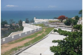
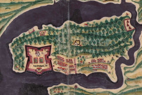
Written by Marco Ramerini. English text revision by Dietrich Köster.

After the conquest, in 1415, of the Arab stronghold of Ceuta in Morocco, the Portuguese were the first Europeans to explore the African coast, and in the 1460s they built the first fort in Arguin (Mauritania). 1482 was the year of the construction of São Jorge da Mina Castle on the Gold Coast (Ghana). In 1487 the Portuguese explorer Bartolomeu Diaz rounded the Cape of Good Hope and in 1497 Vasco da Gama circumnavigated the African continent and arrived in India (1498).

The Portuguese practically ruled undisputed on the African coast during the 15th and 16th centuries. The Portuguese settlements in Africa were used by the Portuguese ships as supplying stations on the route to India, but they were also trading stations, where the Portuguese traded in gold, slaves and spices with the Africans and the Portuguese language was used as Lingua Franca along the African sea shores.

Now Portuguese is spoken in several nations of Africa, mainly in the former Portuguese colonies: It is the official language in Mozambique, in Angola, in São Tomé and Príncipe, in Guinea-Bissau and on the Cape Verde Islands; a creole kind of Portuguese is used in Senegal, in Guinea-Bissau, on the Cape Verde Islands, in São Tomé and Príncipe and also in Equatorial Guinea. A large community of Portuguese from Portugal, Angola and Mozambique resides in South Africa.

The Portuguese language has also influenced several African languages. Many Portuguese words were permanently lent to various kinds of African languages such as Swahili and Afrikaans.

WEST AFRICA COAST and CAPE VERDE ISLANDS

In the 16th century along the coast of Senegal, Gambia and Guinea, the settlement of several groups of Portuguese merchants and Lançados (mixed-race) contributed to the spread of the Portuguese language in those areas. Today a Portuguese Creole is still spoken in Casamance (Ziguinchor Creole in Senegal and Gambia) and Guinea-Bissau (Bissau-Bolama Creole, Bafatá Creole and Cacheu Creole), its local name being Kriol (Crioulo). This language is the first creole language which emerged from the contact between Europeans and the African peoples.

In Guinea-Bissau Kriol is the national language and Portuguese is the official language. The Cape Verde Islands were a Portuguese colony till 1975, and thus Portuguese is today the official language of the archipelago. The Cape Verde Creole (Kriol or Crioulo) is spoken by the whole population and it is similar to that of Guinea-Bissau and Casamance. Portuguese is the second language for many people.

Cape Verde: 350,000 Cabo Verde Creole first language speakers (1990), Portuguese is the second language for the majority.

Guinea-Bissau: 150,000 Creole first language speakers (1996) and 600,000 second language users; 20,000 Portuguese first language speakers (1991).

Senegal and Gambia: 55,000 Ziguinchor Creole first language speakers (1990). The Senegal dialect is a little different from that in Guinea-Bissau, with some French vocabulary.

[divider]

Portuguese speaking communities in Africa today. Author Marco Ramerini
Portuguese speaking communities in Africa today. Portuguese language heritage in Africa. Author Marco Ramerini

[divider]

GULF OF GUINEA

A kind of Portuguese language (Creole) developed along the coast of Ghana (Gold Coast) and was spoken by native traders in their dealings with the other Europeans (Dutch, English, Danes, Brandenburghers, French, Swedes), during the 16th, 17th and 18th centuries, even several years after the Portuguese abandonment of the Gold Coast. Till 1961 Portugal had a fort in Dahomey, now called Benin. Its name is São João Baptista de Ajudá (Ouidah). Here Portuguese was used in the past centuries by a community of mixed Portuguese descendants. Portuguese was also used in the Kingdom of Dahomey as language for the external relations with the other Europeans.

On several islands of the Gulf of Guinea the Portuguese Creole is still spoken today. These islands are: São Tomé and Príncipe islands (São Tomé & Príncipe), Annobon island (Equatorial Guinea). São Tomense (Forro) and Angolar (Moncó) are spoken on São Tomé Island, Principense on Principe Island. These Creoles are quite distinct from the Creoles of Cape Verde, Guinea-Bissau, Senegal and Gambia.

Portuguese is the official language of São Tomé and Príncipe and is spoken as second language by the majority of the inhabitants; in 1993 only 2,580 people used it as first language. On the Island of Annobon (Pagalu, Equatorial Guinea), the population speaks a particular sort of Portuguese Creole, called Annobonese or Fá d’Ambô, a rare mixture of Angolan Bantu dialects and old Portuguese, which is similar to that of São Tomé. The Portuguese became the third official language of Equatorial Guinea since July 20, 2010

São Tomé and Principe: 85,000 São Tomense first language speakers (São Tomé Island), 9,000 Angolar first language speakers (São Tomé Island), and 4,000 Principense first language speakers (Principe Island) (1989); 2,580 Portuguese first language speakers (1993) and a large part of the inhabitants speak Portuguese as second language.

Equatorial Guinea: 8.950 Annobonese first language speakers (Annobon Island) (1993). The Portuguese became the third official language of Equatorial Guinea since July 20, 2010.

SOUTHERN AFRICA: Congo, Angola, South Africa and Mozambique.

During the 16th century in the Kingdon of Congo, many people of the ruling class spoke Portuguese fluently. This language was also the vehicle for the spread of Christianity. The testimony of a European traveler in 1610 prove that in Soyo all children learnt Portuguese. There is proof of the existence in the Congo Kingdom of Portuguese schools managed by the missionaries during the 17th and 18th centuries. In the 16th, 17th and 18th centuries the influence and the use of Portuguese as a trading language spread along the coast of Congo and Angola from Loango to Benguela.

In Angola – a Portuguese colony till 1975 – Portuguese is the official language and is spoken by many people. Most Mestiços (in 1995 about 1,5 % of the Angolan population, that is 170,000) speak Portuguese as household language and they tended to identify with the Portuguese culture. In Mozambique – another Portuguese colony till 1975 – Portuguese is the official language and is spoken by many people, principally as second language. In South Africa Portuguese is spoken by people of Portuguese descent and by the immigrants from Angola, Mozambique and Brazil (600,000).

Angola: 57,600 Portuguese first language speakers (1993) and a large part of the inhabitants speak Portuguese as second language.

Mozambique: 30,000 Portuguese first language speakers (1993) and 4,000,000 second language users, about 30% of the population (1991).

South Africa: More than half a million Portuguese first language speakers.

EAST AFRICA: Kenya and Tanzania.

Portuguese was used as Lingua Franca in the 17th and 18th centuries. This was due to the Portuguese domination of the East Coast of Africa till the end of the 17th century. Mombasa was held till 1698 and a brief reoccupation was attempted in 1728/1729. There is evidence given by an English lieutenant that in 1831 a confused Portuguese was spoken by a man in Mombasa. The contact between the Portuguese and Africans influenced also the Swahili language, which today is used along the whole East African coast. There are more than 120 words of Portuguese origin in the Swahili language.

[divider]

BIBLIOGRAPHY ABOUT THE PORTUGUESE LANGUAGE IN AFRICA:

– Chataigner, Abel “Le créole portugais du Sénégal: observations et textes” ?, in: Journal of African languages Vol. 1,1 1963, pp. 44-71

– Cardoso, Eduardo “O Crioulo da Ilha de São Nicolau de Cabo Verde”, 142 pp., Imprensa Nacional, 1989, Lisbon, Portugal.

– Couto, Hildo Honório do. “The genesis of Portuguese creole in Africa”, in: Holm, John & Frank Byrne (eds.).”Atlantic meets Pacific: a global view of pidginization and creolization”, John Benjamins Publishing Company,1993, Amsterdam, The Netherlands, pp. 381-389.

– Dalphinis, Morgan, “African language influences in Creoles lexically based on Portuguese, English and French with special reference to Casamance Kriul, Gambian Krio and Saint Lucia Patwa”, 756 pp. PhD. Thesis, University of London, 1981, London, United Kingdom.

– Ferraz, Luís Ivens “The creole of São Tomé”, 122 pp., Separata African Studies, 37, Witwatersrand University Press, 1979, Johannesburg, South Africa.

– Günther, Wilfried “Das portugiesische Kreolisch der Ilha do Príncipe” Selbstverlag, 1973, Marburg an der Lahn.

– Kihm, Alain “Kriyol syntax: the Portuguese-based Creole language of Guinea-Bissau”, VIII, 310 pp. Creole language library n° 14, John Benjamins Publishing Company, 1994, Amsterdam and Philadelphia.

– Lorenzino, Gerardo A., “The Angolar Creole Portuguese of São Tomé: its grammar and sociolinguistic history”, 290 pp. Unpublished Ph.D. Thesis, City University of New York, 1998, This Thesis deals with the genesis and development of the Angolar Creole Portuguese of São Tomé and Príncipe (Gulf of Guinea), off the coast of West Africa. Angolar is the language spoken by descendants of maroon slaves who escaped from Portuguese plantations on São Tomé in the mid-sixteenth century.

– Maurer, Philippe “L’angolar. Un créole afro-portugais parlé à São Tomé”, Buske, 1995, Hamburg.

– Moreau, Marie-Louise “Destino de uma sociedade, destino de uma língua. Balizas para a história do crioulo português em Ziguinchor” in: “PAPIA Revista de Crioulos de Base Ibérica”, Universidade de Brasília, Volume 3, nº 1, 1994

– Perl, Mathias “Acerca de Alguns Aspectos Históricos do Português Crioulo em África”, in: “Biblos”, vol. LVIII (Segunda Parte da Homenagem a M. Paiva Boleo), 1-12 pp. FLUC, 1983, Coimbra, Portugal.

– Perl, Mathias “A reevaluation of the importance of early Pidgin/Creole Portuguese”, pp. 125 – 130, JPCL (Journal of Pidgin and Creole Languages) N° 5/1 (April 1990), John Benjamins Publishing Company, Amsterdam and Philadelphia.

– Ploae-Hanganu, Mariana “Le créole portugais de l’Afrique: sa base portugaise”, 2 vols. (251, 58 f.) : [10] maps, 1991, Lisbon.

– Washabaugh, William and Greenfield, Sidney M. “The Portuguese Expansion and the Development of Atlantic Creole Languages” In: “Luso-Brazilian Review” n. 18 (2),1981, 225-238 pp.

Categories
Angola Portuguese Colonialism

Portuguese fortresses of Luanda

Written by Marco Ramerini. Photos by Virgílio Pena da Costa. English text revision by Dietrich Köster.

The city of Luanda, the capital of Angola, was founded by the Portuguese explorer Paulo Dias de Novais on 25 January 1576. The city was named by the Portuguese as “São Paulo da Assumpção de Loanda”. The Portuguese, in the following years, built three fortress: the Fortaleza São Pedro da Barra (1618), the Fortaleza de São Miguel (1575) and Forte de São Francisco do Penedo (1765-6). The best preserved of the Portuguese fortresses of Luanda is that of São Miguel.

FORTRESS OF SÃO MIGUEL

The Fortress of São Miguel in Luanda is located near the bridge, which connects the island of Luanda (Restinga) to the mainland, high above on the hill of São Paulo. The fortress has a complex plant of polygonal shape with numerous bastions, being in excellent state of preservation.

The initial fort was built by the first Portuguese governor of Angola Paulo Dias de Novais in 1575. It was the first fort to be built in Luanda, in the sixteenth century, the fort was first built of rammed earth and adobe (a natural building material made from sand, clay, water, and some kind of fibrous or organic material), substutuídos later by clay, rammed earth and adobe.

The fortress was restored and reinforced in 1634, when the Portuguese, fearful of an attack by the Dutch, rebuilt and renovated the city’s defenses. Nevertheless the city of Luanda and the fortress of São Miguel were occupied by the Dutch in 1641. During their period of occupation, which lasted until 1648, the fortress was known as Fort Aardenburg.

The current appearance of the fort dates from the late 17th century, when under the government of Francisco de Távora (1669-1676) the fort was rebuilt in brick and completed by a new bulwark and two curtain walls. Today the fortress houses the Museum of the Armed Forces (Museu das Forças Armadas).

Categories
Colonial Forts on Google Earth Kenya Portuguese Colonialism

Fort Jesus Mombasa: a Portuguese fortress in Kenya


Written by Marco Ramerini. English text revision by Dietrich Köster.

In 1498 the Portuguese explorer Vasco da Gama arrived in Mombasa on his route to India. Fort Jesus was built after the Portuguese had become masters of the East African coast for nearly a hundred years. During this time they had as main base an unfortified factory at Malindi.

The Turkish raids of 1585 and 1588 were decisive for the Portuguese to decide on the construction of the fort in Mombasa. On 11 April 1593 the fortress was dedicated and named “Fortaleza de Jesus de Mombaça” by Mateus de Mendes de Vasconcelos (he was the captain of the coast, residing at Malindi). The fort was completed in 1596, the plan was a quadrilater with four bastions: S. Felipe, S. Alberto, S. Mathias and S. Mateus. The main gate was near S. Mathias bastion. Above the gate is a Portuguese inscription, which records the dedication to the fort: “Reinando em Portugal Phellipe de Austria o primeiro … por seu mandado ……. fortaleza de nome Jesus de Mombaça a omze dabril de 1593 ….. Visso Rei da Índia Mathias Dalboquerque ……. Matheus Mendes de Vasconcellos que pasou com armada e este porto ……. arquitecto mor da Índia João Bautista Cairato servindo de mestre das obras Gaspar Rodrigues.”

Fort Jesus, located on the edge of a coral ridge overlooking the entrance to the Old Port of Mombasa, was built by the Portuguese in 1593-1596 to protect their trade route to India and their interests in East Africa. It was designed by the Italian architect Giovanni Battista Cairati*. Mombasa became Portugal’s main trading centre along the East Coast of Africa.

The relation between the Portuguese and the Sultan of Mombasa began to deteriorate after the departure of the first captain Mateus de Mendes de Vasconcelos. In 1626 Muhammad Yusif, who had received education in Goa and who was baptized as Dom Jerónimo Chingulia, was made Sultan. On 16 August 1631 the Sultan Dom Jerónimo Chingulia entered the fort and took the Portuguese by surprise. He killed the Portuguese captain Pedro Leitão de Gamboa and massacred the whole Portuguese population of Mombasa (45 men, 35 women and 70 children). A Portuguese expedition was sent from Goa to retake the fort, but after two months of siege (10 January 1632-19 March 1632) they abandoned the enterprise. On 16 May the Sultan abandoned Mombasa and became a pirate. On 5 August 1632 a small Portuguese force under the captain Pedro Rodrigues Botelho, who had remained in Zanzibar, reoccupied the fort.

In February 1661 the Sultan of Oman sacked the Portuguese town of Mombasa, but did not attack the fort. It was in 1696 that a large Omani Arab expedition reached Mombasa. From 13 March 1696 the fort was under siege, the fort having a garrison of 50-70 Portuguese soldiers and several hundred loyal Coast Arabs. The fort was relieved in December 1696 by a Portuguese expedition, but in the following months a plague killed all the Portuguese of the garrison and by 16 June 1697 the defence of the fort was in the hands of Sheikh Daud of Faza with 17 members of his family: 8 African men and 50 African women.

On 15 September 1697 a Portuguese ship arrived with some reinforcement and also at the end of December 1697 another ship came from Goa with a few soldiers. After another year of siege the Portuguese garrison was reduced to the Captain, 9 men and a priest (Fr. Manoes de Jesus) in December 1698.

After a siege of two years and nine months the Omani Arabs took the fort. They could do this, because the garrison was reduced to nine soldiers, the others having died by disease. On the morning of 13 December 1698 the Omani Arabs did the decisive attack and took the fort. Just seven days later a Portuguese relief fleet arrived in Mombasa, but it was too late. With the conquest of Fort Jesus the whole coast of Kenya and Tanzania with Zanzibar and Pemba fell into the hands of the Omani Arabs.

The Portuguese retook the fort in 1728, because the African soldiers in the fort mutinied against the Omanis. The Sultan of Pate, to whom the fort was offered, handed the fort over to the Portuguese on 16 March 1728. In April 1729 the Mombasans revolted against the Portuguese and put under siege the garrison, who was forced to surrender on 26 November 1729.

The Fort is today known as one of the best examples of 16th century Portuguese military architecture. In 2011, Fort Jesus was declared a World Heritage Site by UNESCO.

*Giovanni Battista Cairati, born in Milan, was a leading military architect in the the service of King Philip II of Spain, who was also King of Portugal. He worked in Malacca, Mannar, Ormuz, Muscat, Damão, Bassein and Mombasa. He probably never saw Fort Jesus completed, because he died in Goa in 1596.

FORT JESUS TIMELINE

Mombasa: Fortaleza de Jesus (1593), Forte de São Joseph, Fortim da Ponta Restinga, Forte do Sorgidouro, Fortes da Macupa (three forts).

Portuguese: 11 Apr. 1593 Fortaleza de Jesus – 15 Aug. 1631
Sultan of Mombasa: 15/16 Aug. 1631 – 16 May 1632
Abandoned: 16 May 1632 – 5 Aug. 1632
Portuguese: 5 Aug 1632 – 13 Dec. 1698
Oman: 13 Dec. 1698 – Mar. 1728
Portuguese: 16 Mar. 1728 – 26 Nov. 1729
Oman: Nov. 1729 – 1741
Governor of Mombasa: 1741 – 1747
Oman: 1747
Governor of Mombasa: 1747 – 1828 (English protection 1824-1826)
Oman: 1828
Governor of Mombasa: 1828 – 1837
Oman: 1837 – 1856
Zanzibar: 1856 – 1895
English: 1895 – 1963

The Portuguese built several small forts around Fort Jesus in Mombasa for a better defence of the island. So many documentation exists on Fort Jesus, but about the others nearly nothing. There is also a confusion about the names.

The following list is the result of the research work done by Hans-Martin Sommer, M.A. Marine Archaeologist of the Fort Jesus Museum, Mombasa.

Information and photos by Hans-Martin Sommer (M.A. Marine Archaeologist of the Fort Jesus Museum, Mombasa). 

LIST OF PORTUGUESE FORTIFICATIONS IN MOMBASA:

FORT JESUS: the main Portuguese Fortress.

MAKUPA FORTS (Pos: 04 02′ 12,7″ S 39 39′ 09,7″ E): a small fort (15×15 m) and two towers at each side in a distance of about 100 metres.

“Os tres fortes da Macupa sao tres cazas, que estao feitas em quadro, ao longo do rio, na ilha de Mombaça, pera a banda da terra firme, em hum paço seco, os quaes se fizerao pera tolher a passajem aos Muzungulos da tierra firme pera a ilha. O de meyo he mayor, e nao tem mais que hua caza de sobrado com hua logea em baixo, a que se entra e sobe pella mesma logea (que tera sinco braças de vao tanto de largo como de comprido) cuberta por sima de terrado, onde asistem quinze soldados e hum bombardeiro portugues. Aos soldados se paga dezacete larins cada mes de mantimentos e ao capitao cento e sincoenta xerafins de ordinaria cada anno, o qual capitao o he tambem dos outros dois fortes que lhe fica cada hum de sua ilharga, distancia de hum tiro de espingarda pera cada parte, os quaes tamben sao cada hum hua caza de sobrado cuberta de terrado, mais pequena que o de meyo, que terao tres braças do vao. E asistem sinco soldados em cada hua, que pelejao com seus mosquetes por seteiras que estao feitas a rroda.” Antonio Bocarro “O Livro das Plantas de Todas as Fortalezas, Cidades e Povoaçoes do Estado da India Oriental”

Actual situation: This site was destroyed between 1900 and 1920. Rediscovered on July 2006, were found small wall remains in the ground. At the Eastside of the complex (distance to the fort about 120 m) were found the remains of a “wall, made from sundried bricks”. The east-tower was inside the complex. The other one is probably complete destroyed by the road and railway which leads in a distance of 120 m from the fort. The “Fortes de Macupa” were one fort with towers on each side. In Rezendes map of 1635 you can see the buildings of Makupa in nearly real shape.

Recostruction of Makupa Fort. A sketch by Hans-Martin Sommer after the first excavation and additional description of a german explorer in 1865. Exist an old photo from about 1900 which shows the ruins as very similar to the recostruction sketch.

ST. JOSEPH FORT (Pos: 04 04′ 18,1″ S 39 40′ 56.1″ E): a horseshoelike fortification in good condition. At about 100 metres distance to St. Joseph it was the Portuguese chapel “Nossa Senhora das Merces” (Pos: 04 04′ 21,2″ S 39 40′ 50,7″ E).

At about 100 metres distance to St. Joseph there used to be the Portuguese chapel “Nossa Senhora das Mercês” (Pos: 04 04′ 21,2″ S 39 40′ 50,7″ E).

GOLF COURSE FORT (Pos: 04 04′ 20,8″ S 39 39′ 07,5″ E): a few remains near the Golf Course.

HORSE SHOE FORT (Pos: 04 04′ 43,8″ S 39 40′ 20,2″ E): a very small fortification in good condition. Horseshoe Fort is a small bastion in good condition, no much infos available about its history

FORT OF THE ANCHORAGE (Pos: 04 04′ 33,06″ S 39 39′ 52,33″ E): also called ‘the round fort’ or ‘the hexagonal fort”, completly gone.

BIBLIOGRAPHY:

– Hinawi Mbarak Ali “Al Akida and Fort Jesus, Mombasa” 85 pp. East African Literature Bureau, 1950, Nairobi, Kenya.

– Boxer,Ch.R. – de Azevedo,C. “A fortaleza de Jesus e os Portugueses em Mombaça 1593-1729” 127 pp. 6 maps, Centro de Estudos Historicos Ultramarino, 1960 Lisboa, Portugal. History of Mombasa under the Portuguese, description of Fort of Jesus.

– Freeman-Grenville, G. S. P. “The Portuguese on the Swahili Coast: buildings and language” In STUDIA N° 49, pp. 235-253, 1989, Lisbon, Portugal.

– Kirkman,J. “Fort Jesus: a Portuguese fortress on the East African coast” 327 pp. 38 maps, Oxford University Press, 1974 London, United Kingdom. Detailed description of Fort Jesus by an archeological point of view.

– Nelson, W.A. “Fort Jesus of Mombasa” 84 pp. Canongate Press, 1994, Edinburgh, UK

– Pearson,M.N. “Port cities and intruders: the Swahili Coast, India and Portugal in the Early Modern Era” 202 pp. 2 maps, The Johns Hopkins University Press, 1998, Baltimore and London. Index: The Swahili coast and the Afrasian sea; the Swahili coast and the interior; East Africa in the world-economy; the Portuguese on the coast.

Written by Marco Ramerini. English text revision by Dietrich Köster.

Some old walls inside Fort Jesus, Mombasa. Author and Copyright Dietrich Köster
Cannons and buildings inside Fort Jesus, Mombasa. Author and Copyright Dietrich Köster..
This is the plaque presented by the Oman embassy in Kenya to the National Museum of Kenya with some historical dates of Fort Jesus. Author and Copyright Dietrich Köster.
This gun was salvaged from the German warship Konigsberg in World War I. Author and Copyright Dietrich Koster
Categories
Danish Colonialism Dutch Colonialism German Colonialism Ghana Portuguese Colonialism Swedish Colonialism

The European forts in Ghana

Written by Marco Ramerini. English text revision by Dietrich Köster.

FORT SÃO JORGE DA MINA (ELMINA)

The first European-built fort in Ghana was Fort São Jorge da Mina (Elmina), which was built by the Portuguese in 1482 near an African village, with which they traded, called by them Aldeia das Duas Partes. The foundation stone of this castle was laid on 21 January 1482 under the supervision of the Portuguese Captain Diogo de Azambuja, who was at the head of an expedition of 600 Portuguese.

This fort was the Headquarters of the Portuguese on the Gold Coast from its foundations to the Dutch conquest in 1637. The government of this castle was esteemed to be, at the beginning of XVIth century, one of the most important positions in the Portuguese empire. During the Portuguese time the garrison of the fortress consisted of a Governor with his staff of ten people, a factor or feitor with a staff of four men, two clerks, an apothecary, a surgeon, a smith, a cooper, an overseer of provisions, some stonemasons, some carpenters, two or four priests and about 20-60 soldiers.

In 1486 São Jorge was granted the City status, and a wall was built around the African settlement. From the first trading contacts the villagers of Aldeia das Duas Partes developed a kind of Portuguese Creole, which made the relationship between the Africans and the Portuguese easier. This language continued to be used till the XVIIIth century. In the first years of the XVIth century also the conversions of Black people began. In 1503 on the slopes of a hill near the castle was built a small chapel dedicated to Santiago. This chapel was used till 1596, when the building was dismantled.

Elmina Castle was very important for trade purposes. The trade goods of Mina were gold, ivory, sugar, wax, pepper, hides, slaves. Since the beginning of the Portuguese installation at São Jorge they established business relations with the adjoining African states (Akan, Wassaw, Commany, Efutu) to increase the trade. The Portuguese power on the Gold Coast never went beyond the coast-line. They built in 1503 the fort of Santo António de Axim, maintaining intermittently a trading post at Shama and in 1576 a short-lived fortress at Accra.

In 1596 during the government of captain Cristóvão de Melo (1596-1607) a Dutch expedition – equipped by the Dutch commercial trading house of Moucheron – attacked the castle for the first time. The attempt ended in a failure. On 7 September 1606 the Dutch made a second attempt to capture São Jorge; about 600 Dutch soldiers disembarked at Moure and later they marched against São Jorge. The Portuguese governor Dom Cristovão de Melo made a successful ambush with his troops and after two hours of fighting the Dutch were in retreat; in the meanwhile a small Dutch detachment had been sent towards Axim. Here after a fighting the Dutch beat the retreat, too. The Dutch made repeated assaults on São Jorge in December 1606 and January 1607, but finally in January 1607 they gave up. In 1615 a violent earthquake damaged the fortress walls and a bastion collapsed.

[divider]

Map of the Dutch, Portuguese, Danish, Swedish and Brandenburg forts in Ghana

[divider]

The Dutch – after having got knowledge of this – made three unsuccessful attacks against Elmina. In 1625 under the command of the Dutch Admiral Jan Dirickszon Lam a big Dutch squadron of 15 ships, 1.200 Dutch soldiers and 150 African allies anchored near Elmina with the aim to subdue the Portuguese fort. The fort was garrisoned by only 56 men under the Portuguese governor Dom Francisco Sotomaior and were assisted by a number of African allies.

On 25 October 1625 the Dutch opened the battle bombarding the castle. Later the Dutch began to march to São Jorge. The African warriors – allies of the Portuguese – ambushed the Dutch. They were taken by surprise. Confused by the unexpected assault, they beat the retreat leaving on the battle-field about 500 men. Thanks to their African allies this was a great victory for Portugal. In August 1637 a new Dutch squadron of 9 ships and 800 men anchored near Cabo Corso (Cape Coast), where they were joined by some 1.200 African allies. On 26 August 1637 the Dutch landed and – divided in three columns – marched towards the fortress. The first Dutch move in the attack of 1637 was the seizure of the unfortified hill of Santiago, from where they shelled São Jorge castle. By this strategic move the Portuguese were forced to surrender after a few days. The Dutch conquered Elmina on 29 August 1637. A Dutch garrison of 175 men was left in the castle. After more than 150 years a new European power – the Netherlands – ruled on the Gold Coast.

[divider]

Map of the Dutch, Portuguese, Danish, Swedish and Brandenburg forts in Ghana

[divider]

After the conquest the Dutch fortified the hill of Santiago with an earth-work. Later the fort on the hill – called Fort Conradsburg – was improved and enlarged and was completed by 1666. In 1645 the Dutch personnel at Elmina and Conradsburg consisted of 83 men and there were also 184 slaves working in the castle. The fort was in Dutch hands till 1872, when it was sold to the British. Very little of the early Portuguese castle is now visible. The only portion, which has remained intact, is the cistern that dates from 1482. The lay-out of today’s castle is the same, more or less, of the Dutch conquest in 1637. Outside the fort is still well preserved the Dutch Reformed church built at the end of the Dutch rule.

FORT SÃO SEBASTIÃO (SHAMA)

In the early years of Portuguese trading activity on the Gold Coast the first center, which was frequented by them, was the village of Shama, east of Cape Three Points. Here they maintained a small lodge for several years. In 1558 a wooden palisade and a tower were built and a permanent garrison was established. During the early 1600s the garrison of this station was formed by only one official and in 1637 the Dutch, when they occupied it, found this fort abandoned. They garrisoned it with a commander, 4 soldiers and 15 slaves (1645). In 1664 the fort was captured by the English, but a year later the Dutch regained possession of it and rebuilt it. Near the fort they maintained a cotton plantation from 1765 till 1783. This fort was in their hands till 1872, when it was ceded to the British.

FORT SANTO ANTÓNIO DE AXIM (AXIM)

In August 1503 a small trading-post was built by the Portuguese to the west of Cape Three Points. It was called Fort Santo António de Axim and in 1515 this fort was reinforced. The fort was an important trade center during the Portuguese rule. It was garrisoned by 10-20 Portuguese soldiers only, and they were – if necessary – assisted by a force of 150 African allies. After the Dutch capture of São Jorge Axim it remained in Portuguese hands for a few more years. A first Dutch attack was driven back in 1641, but in February 1642 a new attempt was successful and the Dutch occupied the fort. In 1664 the English captured the fort, but the Dutch soon retook it. It was in Dutch hands till 1872, when it was sold to the British.

ACCRA

In 1557 the Portuguese built a small fortified lodge in Accra. In 1576 they decided to enlarge the lodge and to build a strong fort, but in 1577/78 Africans attacked the half-built fort and destroyed it.

FORT NASSAU (MOREE)

Between 1595 and 1600 merchants from the Netherlands founded a small unfortified lodge at Moree for trade in gold. In 1610 the Portuguese made an attack against the Dutch trading station at Moree. They burnt the African village adjoining the lodge. In reaction to this attack the Dutch built their first fort on the Gold Coast in 1612: Fort Nassau. This fort was originally a small earthwork and wooden fort and was built on a hill overlooking the sea at Moree. It was rebuilt and enlarged in 1623-24 and in 1633-34. In 1615 a new Portuguese raid was successful and the African town was newly burnt. Moree was the Dutch headquarters till the conquest of Elmina in 1637. In 1645 the Dutch garrison was composed of 32 men including the commander. There were then a surgeon, a preacher, a coppersmith and 156 slaves working in the castle. Moree was occupied by the British in 1664 and recaptured by the Dutch in 1665. In 1782 it was again in British hands, but the Dutch regained it by treaty in 1785. In the first decades of the 19th century it was abandoned. The remains of this fort are nowadays only very few.

FORT CHRISTIANSBORG (ACCRA)

In 1652 the Swedes built a lodge in Accra and in 1660 it was seized by the Dutch. In 1661 the Danes occupied the place and built a fort named Fort Christiansborg. This fort was situated near two other forts: Fort Crèvecœur and Fort James, the former Dutch and the latter English. The Danish fort was located on a rock cliff near the African town of Osu and its position was the best of the three. The fort was in Danish hands for nearly two hundred years except for a short Portuguese occupation. On 2 December 1680 a Portuguese ship arrived at the Danish fort. The Danish Governor Bolt sold the fort to the Portuguese commander of the ship Julião de Campos Barreto. The Portuguese renamed it Fort São Francisco Xavier and built a chapel in the fort. The Portuguese abandoned the fort on 29 August 1682. It was then occupied by the Akwamu tribe until February 1683, when the Danes from nearby Fort Fredriksborg reoccupied it. In 1685 the Danes moved their headquarters from Fort Fredriksborg to Fort Christiansborg. The fort was square shaped with four bastions. In 1693 an African tribe occupied the fort, but in 1694 the Danes retook it. The Danes made several attempts to establish plantations near the fort and they also established in the early 1800s a hill-station and a plantation thirty–two kilometers inland from Fort Christiansborg at Kpomkpo (Frederiksborg). In 1850 the Danes sold the Castle to the British.

[divider]

[divider]

FORT GROSS-FRIEDRICHSBURG (PRINCESTOWN)

Brandenburg was a historic Electorate (Kurfürstentum) which formed the primary nucleus of the Prussian State. Under the reign of the Grand Elector Friedrich-Wilhelm von Brandenburg, was created an African Company, this company for about forty years ruled on several African forts at: Arguin, Takrama, Takoradi, Akwida (Ft. Dorothea), Whydah and Princestown or Poquefoe (Gross-Friedrichsburg). On New Year’s Day 1683 a Brandenburg expedition of two ships arrived on the Gold Coast and started to build a strong fort between Axim and Cape of Three Points, which was named Gross-Friedrichsburg. The fort was to be the headquarters of Brandenburg in Africa, it was garrisoned at the beginning by 91 European men and 130 Africans. The fort was a square shaped with four bastions. In the first 15 years the Brandenburgers developed well the trade with the Africans, but from 1700 trade began to decline. The Company was an ally of the African chief John Couny who was waging a war against the Dutch and the English. In 1720 a treaty was concluded between the King of Prussia and the Dutch, and all the African forts of Brandenburg were sold to the Hollanders, but the African ally of Prussia/Brandenburg, John Couny, refused to surrender Gross-Friedrichsburg. In 1725 the Dutch captured Fort Gross-Friedrichsburg and renamed it Fort Hollandia. The fort was abandoned by the Dutch in 1815.

FORT AMSTERDAM (CORMANTINE)

In 1631 the English had a lodge in Cormantine. In 1645 they built a fort on the summit of a hill. In 1665 the Dutch occupied it during a struggle and renamed it Fort Amsterdam. In 1782 the Dutch surrendered the fort to the British, but in 1785 it was newly in Dutch hands by a treaty. In 1811 the African tribe of Anomabu captured the fort, which was later abandoned.

[divider]

[divider]

BIBLIOGRAPHY ON THE EUROPEANS FORTS IN GHANA

– Bato’ora Ballong -Wen-Mewuda, J. “São Jorge da Mina 1482-1637” 2 voll. 642 pp. Fondation Calouste Gulbenkian-C.N.p.l.C.d.D.P. 1993 Lisboa-Paris Complete study on Elmina castle during the Portuguese period.

– Cardinall, Allan Wolsey “A Bibliography of the Gold Coast” Martino Publishing & Wayfarer’s Bookshop, Mansfield Centre, 2002, CT

– Decorse, Christopher “An Archaeology of Elmina : Africans and Europeans on the Gold Coast, 1400-1900” Smithsonian Institution Press, 2001

– Ephson, I. S. “Ancient forts and castles of the Gold Coast (Ghana)” 112 pp. 18 ills. Ilen Publications 1970 Accra, Ghana Index: The origins; location of the forts and castles; number of forts and castles; the tenants; unhappy incident; gallant governors; problems of the forts and castles; no more forts and castles; cui bono; the surviving settlements.

– Feinberg, Harvey M “Africans & Europeans in West Africa: Elminans & Dutchmen on the Gold Coast during the Eighteenth Century” 189 pp. Diane Publishing Co., 1989 The town of Elmina was the most important trading center on the Gold Coast (GC) of W. Africa for at least 2 cent. Elminans engaged in commercial transactions which linked the GC with 3 very different trade networks. Contents: (I) The Akan on the GC; (II) Europeans on the GC: The Portuguese, 1471-1642; & The Dutch from 1593; (III) Akan Participation in the Atlantic Trading System; (IV) An Intro. to Elmina; (V) The Elmina Political Framework; (VI) The Functioning of Govt.: Justice & Dispute Settlement; & Foreign Affairs; & (VII) Elmina-Dutch Relations. Appendices: Elmina Chronology; Weights, Measures & Def.; Dirs. Gen. & Pres. of the 2nd W. India Co.; Counts of Indictment & Defense of the Negroes of Mina; & Elmina Leaders. Biblio. Illustrations.

– Giordano, Rosario “Religione e politica nel confronto tra missionari cattolici e brasiliani a Ouidah, 1861-1871” In: “Africa” LIII, 2, 1998, pp. 239-257

Iria, Alberto “Da fundação e governo do Castelo ou Fortaleza de São Jorge da Mina pelos Portugueses e da sua acção missionaria após o descobrimento desta costa” In STUDIA N° 1, pp. 26-69, 1958, Lisboa, Portugal.

– Kessel, Ineke van “Merchants, Missionaries and Migrants: 300 Years of Dutch-Ghanaian Relations” Kit Publishers, In November 1701, David van Nyendael, an envoy of the Dutch West India Company (WIe was the first European to visit the royal court in Kumasi, capital of the emerging Ashanti empire in the hinterland of the Gold Coast. Three hundred years of Dutch-Ghanaian relations have passed since then. “Merchants, Missionaries and Migrants” focuses on various aspects of this long-standing and intricate economic, political and cultural relationship between the Ghanaians and the Dutch. Experts from Ghana, the Netherlands, Suriname and Indonesia present their research findings in fascinating histories. They describe a wide range of topics from Dutch-Ghanaian history: from the trade in gold, ivory and slaves to the cocoa trade; from liaisons between European men and African women in previous centuries to present-day Ghanaian migration to the Netherlands; from the involuntary migration of tens of thousands of slaves to the plantations in Suriname to the largely forgotten history of the African soldiers who sailed from Elmina to serve in the Dutch army in the East Indies; and from the role of Dutch geneva in Ghanaian ritual to the tragic story of Jacobus Capitein, the first black Christian minister to be ordained in the Netherlands.

– Lawrence, A. W. “Trade Castles and Forts of West Africa” 390 pp. 48 maps & 158 plates Jonathan Cape 1963 London, U.K. A detailed description of about 40 Europeans forts and castles from Arguin (Mauritania) to Whydah or Ouidah (Benin). Many illustrations and maps of the forts. Chronological history of the forts. Index: The place of the fortsystem in history; the setting of times; organization and personnel; life at the forts; relations between fort and town; types of building; materials and structure; early draughtsmen; Elmina castle: the Portuguese and later Dutch headquarters; other headquarters: Cape Coast Castle, Christiansborg, Princestown; early forts: Axim, Mouri, Cormantin, Gambia, Butre, Shama; forts about 1700: Akwida, Commenda, Dixcove, Apam, Sekondi, Beraku; forts of the late eighteenth century: Anomabu, Beyin, Keta.

– Pezzoli, G. & Brena, D. “Forti e castelli di tratta” 50 pp. Centro Studi Archeologia Africana, 1990, Milano. A collection of several plates of European castles in Africa.

– Van Dantzig, A. “Forts and castles of Ghana” Sedco, 1980, Accra, Ghana. – Van Dantzig, A. and Priddy, B. “A short history of the forts and castles of Ghana” 59 pp. map and ills. Liberty Press, 1971, Accra, Ghana. Index: The Portuguese period, Dutch penetration and the expulsion of the Portuguese, English Swedish and Danish penetration, growth of the English trade, the Brandenburg Company, the 18th. century, the 19th century.

– Vasconcelos, Frazão de “A Fortaleza de São Jorge da Mina” 14 pp., [2] pp. Mundo Português, 1934, Lisboa, Portugal.

– Vogt, J. “Portuguese rule on the Gold Coast 1469 – 1682” 266 pp. 2 maps University of Georgia Press 1979 Athens, Georgia, USA Complete study on the Gold Coast during the Portuguese period.