Colonial Forts on Google Earth, Oman, Portuguese Colonialism
12,075 Views
Written by Marco Ramerini. Photos by Fritz Gosselck and João Sarmento. English text revision by Dietrich Köster. Oman is a country rich in fortifications, some of these were built along the Omani coast by the Portuguese in the sixteenth and seventeenth century, often altered from the original forms several forts built or modernized by the Portuguese are still visible today. ...
Read More »
Dutch Colonialism, Malaysia, Portuguese Colonialism
12,267 Views
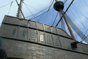
Written by Marco Ramerini. Photos by Krzysztof Kudlek. English text revision by Dietrich Köster. The city of Malacca was conquered by the Portuguese in 1511. Soon after the conquest of the city, which was the most important commercial port in Asia, Afonso de Albuquerque built a fortress to defend the new Portuguese possession. The first fort, “A Famosa”, was built ...
Read More »
Malaysia, Portuguese Colonialism
11,022 Views
Written by Marco Ramerini. Photos by Krzysztof Kudlek. English text revision by Dietrich Köster. The “Flor do Mar” or “Flor de la Mar” was a Portuguese galleon of 400 tons, which was part of the fleet sent to conquer the city of Malacca in 1511. The vessel was built in Lisbon in 1502 and at the time of its construction it ...
Read More »
Dutch Colonialism, Macau
1,667 Views
Photos by Magiel Venema. English text revision by Dietrich Köster. The Dutch have never had control over the Portuguese colony of Macao. But despite this they have used this Portuguese outpost in China for their trade. This is evidenced by the numerous tombs Dutch in the two ancient cemeteries of the city: the Roman Catholic cemetery and the Old Protestant Cemetery. The Roman ...
Read More »
Asia, Portuguese Colonialism, Portuguese language
4,043 Views
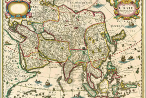
Written by Marco Ramerini. English text revision by Dietrich Köster. The Portuguese language has been in relation to the trade and colonial expansion of Portugal the trade language of the Indian Ocean shores in the 16th, 17th and 18th centuries. Portuguese was used, at that time, not only in the eastern cities conquered by the Portuguese but was also used ...
Read More »
Indonesia, Portuguese Colonialism
2,775 Views
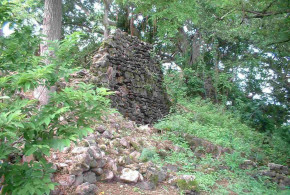
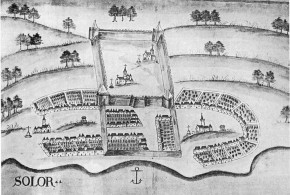
Written by Mark Schellekens. Photos by Mark Schellekens and Greg Wyncoll. English text revision by Dietrich Köster. On January 7th I paid a visit to the island of Solor off Flores’ north east coast. My main goal was to have a birdwatching trip on an virtually unknown island combined with a visit to the ruins of the fort. Solor is ...
Read More »
Indonesia, Portuguese Colonialism
2,077 Views
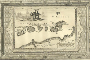
Written by Marco Ramerini. English text revision by Dietrich Köster. SOLOR AND THE LESSER SUNDA ISLANDS The early Portuguese contact with these islands was in the years about the 1520s. They frequented these islands mainly to purchase sandalwood. The early traders established only temporary warehouses. They did not build permanent trading posts, farms or fortresses, because this task was left ...
Read More »
Indonesia, Moluccas, Portuguese Colonialism
10,867 Views
Written by Marco Ramerini. English text revision by Dietrich Köster. TERNATE AND TIDORE The first Portuguese expedition to the Moluccas under the command of António de Abreu arrived in Amboina and on the Banda islands in 1512. After an adventurous voyage he went back to Malacca. Francisco Serrão and other members of this expedition wrecked on a reef off Lucopino ...
Read More »
Indonesia, Moluccas, Spanish Colonialism
16,812 Views
Written by Marco Ramerini. English text revision by Geoffrey A. P. Groesbeck The islands formerly known as the Moluccas – the Spice Islands – are five islands of volcanic origin (Ternate, Tidore, Moti, Makian, and Bacan). They are found off of the west coast of the island of Halmahera, in the Indonesian archipelago. These islands were the only ones in ...
Read More »
Dutch Colonialism, Indonesia, Malaysia, Moluccas, Philippines, Spanish Colonialism
1,648 Views
Written by Marco Ramerini. English text revision by Dietrich Köster. English translation of a small part of my work entitled “La presenza Spagnola alle Isole Molucche, 1606-1663”. In the propositions of the governor of the Philippines, Don Juan de Silva, a big joint expedition of Spaniards and Portuguese should succeed in getting rid of the Dutch forces present in Indonesian ...
Read More »
Indonesia, Portuguese Colonialism
3,407 Views
Written by Marco Ramerini. English text revision by Dietrich Köster. Ambon is an island located in the south of the Spice Islands in what is today the Indonesian archipelago. In the year 1569 the Portuguese Gonçalo Pereira Marramaque erected a wooden fort on the northern coast of the Ambon island. In 1572 the fort was moved to the southern side ...
Read More »
Indonesia, Moluccas, Portuguese Colonialism
2,792 Views
Written by Marco Ramerini. English text revision by Dietrich Köster. The Portuguese fort of Ternate was founded by António de Brito in 1522, the foundation stone of the fortress was laid the day of the feast of St. John the Baptist, June 24, 1522, the fort was named “São João Bautista de Ternate.” The outer wall of the fortress enclosing ...
Read More »
Indonesia, Portuguese Colonialism
2,990 Views
Written by Marco Ramerini. English text revision by Dietrich Köster. The Kingdom of Makassar at the time of Portuguese expansion in the Asian seas comprised the two Kingdoms of Gowa and Tallo. Portuguese merchants frequented Makassar intermittently during the 16th century, but it was only after the Islamization of the Makassar Kingdom (1600s), that their presence grew. During the 17th ...
Read More »
Indonesia, Portuguese Colonialism
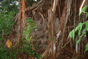
1,388 Views
Written by Marco Ramerini. In 1595, the Dominican friars led by Brother Simone Pacheco built a little Fort on the island of Ende Minor (Palau Ende) to protect local Christians from Islamic attacks. This small fort was named by the Portuguese as Fortaleza de Ende. Pero Carvalhais was its first captain. Within the walls of the fort was built the ...
Read More »
Danish Colonialism, India
7,518 Views
Written by Marco Ramerini. Tranquebar (Tharangambadi) is a small village in Tamil Nadu in India located on the Coromandel coast about 30 km north of Nagapattinam. Tranquebar has the distinction of have been a Danish colony between 1620 and 1845. The Danes in 1620 founded the Fort Dansborg and made it their main trading settlement along the Indian coast. Tranquebar (Dansborg ...
Read More »
India, Portuguese Colonialism
2,635 Views
Written by Marco Ramerini. English text revision by Dietrich Köster. Diu: (20°43’N – 71°00’E) Damão Grande or Praça de Damão (Damão, Moti Daman or Daman): (20°25’N – 72°50’E) 1634: 400 “almas entre portugueses e nativos cristãos”. Source: Leão “A Província do Norte do Estado da Índia” 1662: 100 “casais portugueses”. Source: Leão “A Província do Norte do Estado da Índia” ...
Read More »
India, Portuguese Colonialism
15,269 Views
Written by Marco Ramerini. English text revision by Dietrich Köster. Goa is situated on an island at the mouth of the Mandovi River. At the time of the arrival of the Portuguese in India, Goa was under the rule of the Sultan of Bijapur, for whom Goa was the second most important city. It was wealthy and possessed a grand ...
Read More »
Dutch Colonialism, India
9,175 Views
Written by Marco Ramerini. English text revision by Dietrich Köster. In 1650 the VOC possessed only the unfortified factories in Kayamkulam and Cannanore. But at the end of the hostilities with the Portuguese in 1663 the Dutch became the new rulers of the Malabar Coast. They possessed military outposts at 11 places: Alleppey, Ayacotta, Cheramangalam, Pappinivattam, Ponanni, Pallipuram, Cranganore, Chettuwaye, ...
Read More »
India, Portuguese Colonialism
18,756 Views
Written by Marco Ramerini. English text revision by Dietrich Köster. The city of Cochin (today: Ernakulam) was from the 24 December 1500, when the first Portuguese fleet called on its port, a firm ally of the Portuguese. The admiral of this fleet was Pedro Alvares Cabral (the discoverer of Brasil). The Rajah (king) of Cochin allowed, a “feitoria” (factory) to ...
Read More »
India, Portuguese Colonialism
3,831 Views
Written by Marco Ramerini. English text revision by Dietrich Köster. The Portuguese town of Chaul lies about 350 kilometers north of Goa and 60 kilometers south of Bombay (Mumbai) at the mouth of the Kundalika river near the village of Revdanda. Chaul was located on the low northern bank, opposed to a promontory on the south bank, which is called ...
Read More »