Categories
Africa America Asia Danish Colonialism

List of Danish colonial forts and possessions

Written by Marco Ramerini

DANISH COLONIAL SETTLEMENTS

ASIA

INDIA:

Tranquebar (Dansborg castle):

Danish: 1620-May 1801

English: (May 1801-Aug. 1802)

Danish: Aug. 1802-1808

English: (1808-20 Sep. 1815)

Danish: 20 Sep. 1815-7 Nov. 1845

English occupation: (7 Nov. 1845- 1947)

(U. B. J. p 41, 44) (H.F. p 298)

Pipely (Pipli): factory

1625- abandoned before 1643 (U. B. J. p 28)

Masulipatam: factory

1626 -abandoned before 1643 (U. B. J. web site)

Balasore: factory

1636-abandoned before 1643 1763-1845 (C. p 126) (U. B. J. web site)

Oddeway Torre (Malabar coast):

factory 1696 – 1722 (U. B. J. web site)

Gondalpara (Dannemarksnagore) (S-E of Chandernagore): Fortified factory

A part of Gondalpara is still (1919) called “Dinemardanga”, that is the land of the Danes.

1698/1700-1714 abandoned (C. p 126+U. B. J. p 28)

Calicut: factory

1752-1791 abandoned (U. B. J. p 29, 37)

Serampore (Frederiksnagore):

Danish: Oct. 1755-1808

English: (1808-1815?)

Danish: 1815 ?-11 Oct. 1845

English: (11 Oct. 1845-1947)

(C. p 126) (U. B. J. p 28, 41, 44) (H.F. p 302) (R. p 232)

Colachel (Malabar coast): factory

1755-1824 abandoned (U. B. J. p 29, 37)

NICOBAR ISLANDS (Frederik Oerne islands):

Grand Nicobar (Sambellong, northern side of the island):

1754/56-1760 abandoned (B2 p?) (R. p 232)

Kamorta island (Canlaha or Frederikshoi):

1760- 1768 abandoned (B1 p?) (B2 p?)

Nangkowry island:

Danish: 1768 Danish Mission -1773 abandoned

Danish: 1784 -1807/9 abandoned

Danish: 1830-1834 abandoned

Danish: 1846- ? abandoned

Denmark officially handed over the rigths of the Nicobar Islands to the British on 16 October 1868.

(B1 p?) (B2 p?) (U. B. J. p 29, 30)

SRI LANKA:

Trincomalee:

1620-1621 attempt to build a fort (U. B. J. p. 11,12)

INDONESIA:

Macassar (Sulawesi island): factory

? (H.F. p 326)

Bantam (Java island): factory

?-1682 (H.F. p 300)

AFRICA:

SIERRA LEONE:

Bagos:

16 lodge – 16

1661 lodge – Dec. 1662 destroyed by the Dutch (Nørregård “Danish settlements in West Africa 1658-1850” p. 25)

GHANA:

Cape Coast or Cabo Corço (Swedish name: Carolusborg or Carlsborg):

The Portuguese, English and Dutch had trading lodges in Cape Coast, but when the Swedes arrived they were unoccupied.

Swedish: (Apr. 1650 fort Carolusborg – Jan./Feb. 1658)

Danish: Jan./Feb. 1658 – 16 Apr. 1659

Dutch: (16 Apr. 1659- May/Jun. 1659)

Fetu: (May/Jun. 1659 – 10 Dec. 1660)

Swedish: (10 Dec. 1660 – 22 Apr. 1663)

Dutch: (22 Apr. 1663 – 3 May 1664)

English: (3 May 1664 – 1957)

(According to Nørregård “Danish settlements in West Africa 1658-1850”)

Dutch: 1638 factory – ? abandoned

Swedish: (1657-1658) the Swedes built the fort in 1657

Danish: 1658 – Apr. 1659

Dutch: (Apr. 1659-1659)

Fetu: (1659- 10 Dec. 1660)

Swedish: (10 Dec. 1660 -1660)

Danish: 1660-1663

Fetu: (1663-1663)

Dutch: (1663-1664)

English: (1664-1957)

(According to Lawrence “Trade castles and forts of West Africa” p 198)

Cape Coast or Cabo Corço:

Danish: 1659 lodge – 23 Mar. 1664 destroyed by the Dutch

Danish: May 1664 lodge – ?

(Nørregård “Danish settlements in West Africa 1658-1850” p. 26)

Cong (Cong Height):

Dutch: (? – 1659 abandoned)

Danish: 1659 – 24 Apr. 1661 destroyed by the Dutch

(Nørregård “Danish settlements in West Africa 1658-1850” p. 24)

Gemoree or Jumoree: 

Its location is not known.

Swedish: (165 ? fortified lodge – 1658)

Danish: 1658 – ? (Nørregård “Danish settlements in West Africa 1658-1850”)

Takoradi: (04°53’N – 01°45’W)

Swedish: (1653 fortified lodge – 1658)

Danish: 1658 – Apr. 1659 abandoned

Adja or Agga:

1658 lodge – ? (Nørregård “Danish settlements in West Africa 1658-1850”)

Anomabu:

Dutch: (1640 lodge – ?)

Swedish: (1652 lodge – 1658)

Danish: 1658 lodge – Apr. 1659 abandoned

Dutch: (lodge)

English: (166 ? lodge – ?)

(Van Dantzig “Les Hollandais sur la côte de Guinée 1680-1740”, A. W. Lawrence “Trade castles and forts of West Africa” p. 198, Nørregård “Danish settlements in West Africa 1658-1850”)

Amanful or Amanfro, Cape Coast (Ft. Fredriksborg or Frederiksberg): 

Danish: 1659 fort – 16 Apr. 1685

English: (16 Apr. 1685 – ) called by the British: Fort Royal.

(L. p 199) (E. p. 32; 40; 85) (Nørregård “Danish settlements in West Africa 1658-1850” )

Accra-Osu (Ft.Chistiansborg): 

Swedish: (1652 fortified lodge – 1658)

Danish: 1658 lodge – Apr. 1659 abandoned

Danish: 1661 fort – Dec. 1680

Portuguese: (Dec. 1680-29 Aug. 1682) abandoned

Akwamu: (Sep. 1682-Feb. 1683)

Danish: Feb. 1683-1693

Akwamu: (1693-1694)

Danish: 1694-1850

English: (1850-1957) (L. p 199-217)

(V. p 202-204) (E. p.83) (Nørregård “Danish settlements in West Africa 1658-1850” p. 10)

Provesten:

Watch-tower situated several hundred yards west of Christiansborg.

Before 1729-1850

Ningo (Ft.Fredensborg): 

Danish fort 1734 – Mar. 1850

English: (Mar. 1850-1957)

(E. p. 32; 40; 83)

Ada (Ft. Kongensten): 

Danish fort 1784 – Mar. 1850

English: (Mar. 1850-1957)

(E. p. 32; 40; 83)

Teshe (Ft. Augustaborg): 

Danish fort 1787- Mar. 1850

English: (Mar. 1850-1957)

(L. p 87) (E. p. 32; 40; 83)

Keta (Ft. Prinsensten):

Danish: lodge 1780 fort 1784 – 12 Mar. 1850

English: (12 Mar. 1850-1957)

(L. p 361-368) (E. p. 32; 40; 83)

Kpomkpo (Frederiksberg):

Hill-station 1788- ? (L. p 43)

SÃO TOMÉ:

São Tomé: lodge ?

Nørregård “Danish settlements in West Africa 1658-1850” p. 30

AMERICA, CARIBBEAN:

VIRGIN ISLANDS:

St. Thomas Island:

Danish: 1672- Apr. 1801

English: (Apr. 1801-Feb. 1802)

Danish: Feb. 1802-1807

English: (1807-1815)

Danish: 1815-31 Mar. 1917 (31 Mar 1917 sold to USA).

(W. p 2, 251, 261)

St. Jan Island (St. John):

Danish: 1716/17- Apr.1801

English: (Apr. 1801-Feb. 1802)

Danish: Feb. 1802-1807

English: (1807-1815)

Danish: 1815-31 Mar. 1917 (31 Mar 1917 sold to USA).

(W. p 2, 251, 261)

St. Croix Island:

French: (? -1733)

Danish: 1733 – Apr. 1801 (The Danes purchased St. Croix from France in 1733)

English: (Apr. 1801-Feb. 1802)

Danish: Feb. 1802-1807

English: (1807-1815)

Danish: 1815-31 Mar. 1917 (31 Mar 1917 sold to USA).

(W. p 2, 251, 261)

GREENLAND:

ICELAND:

FAROE:

Legend:
U.B.J.= Uno Barner Jensen “Danish East India: trade coins and the coins of Tranquebar” Brovst, 1997
C.= Campos “History of the Portuguese in Bengal” Calcutta, 1919
B1= Babudieri “L’espansione mercantile Austriaca nei territori d’oltremare nel XVIII sec. e i suio riflessi politici ed economici” Milano, 1978
B2= Babudieri “Trieste e gli interessi Austriaci in Asia nei sec. XVIII-XIX” Padova, 1966
W= Westergaard “Danish West Indies under company rule 1671-1754, with a supplementary chapter 1755-1917” New York, 1917
L.= Lawrence “Trade castles and forts of West Africa” London, 1963
V.= Vogt “Portuguese rule on the Gold Coast 1469-1682” Athens, 1979
H.F.= Holden Furber “Imperi rivali nei mercati d’oriente 1600-1800” Bologna, 1986 English edition: “Rival Empires of trade in the Orient 1600-1800” Minneapolis, 1976
R.= Reinhard “Storia dell’espansione europea” Napoli, 1987 German edition: “Geschichte der europäischen Expansion” Stuttgart, 1983
E.= Epson “Ancient forts and castles of the Gold Coast (Ghana)” 1970

Categories
Africa Dutch Bibliographies Dutch Colonialism

Africa. Bibliography of Dutch Colonial History 17th-18th century

Written by Marco Ramerini. English text revision by Dietrich Köster.

DUTCH EMPIRE: AFRICA

MAURITANIA:

– Monod,Th., “L’île d’Arguin (Mauritanie), essai historique” 327 pp., 5 maps, IICT and CECA 1983, Lisbon, Portugal. Detailed research on Arguin castle history during the Portuguese, Dutch and Brandenburg periods.

WEST AFRICA, GHANA (GOLD COAST):

– Various Authors, “John Conny & Goombay Drum ignite the imagination of the African Diaspora”, pp. 84-88, in: Angwandah, J. Kwesi, “Castles and forts of Ghana”, Ghana Museums and Monuments Board, Atlante, 1999, Paris, France.

– Anqwandah, J. Kwesi “Castles and forts of Ghana”, Ghana Museums and Monuments Board, Atlante, 1999, Paris, France.

– Clement, Jan J., “De West-Indische Compagnie op de Goudkust in West-Afrika” Vol. 1: “Butler’s Bittere Jaren (omstreeks 1721)”, 356 pp. 1999, Rotterdam, The Netherlands. This volume contains the correspondence between Willem Butler during his directorship at Elmina from 1718 to 1722 and the directors of the WIC.

– Clement, Jan J., “De West-Indische Compagnie op de Goudkust in West-Afrika” Vol. 2: “Dagregister Elmina 1721”, 320 pp., 1999, Rotterdam, The Netherlands. This volume contains the complete Journal or day-book (Dagregister) of Elmina of the 1721.

– Clement, Jan J., “De West-Indische Compagnie op de Goudkust in West-Afrika” Vol. 3: “Acht bevelhebbers op de Goudkust”, 386 pp., 1999, Rotterdam, The Netherlands. This volume contains selected pieces of correspondence from several directors-general during the period 1700-1726.

– Daaku, Kwame Yeboa “Trade and politics on the Gold Coast 1600-1720, a study of the African reaction to European trade”, xviii, 219 pp., Clarendon, 1970, London, United Kingdom.

– Decorse, Christopher, “An Archaeology of Elmina : Africans and Europeans on the Gold Coast, 1400-1900”, 2001, Smithsonian Institution Press, 2001.

– Doortmont, Michel, “Consular and diplomatic ties between Ghana and the Netherlands: a longstanding relationship”, Internet article, 1999

– Doortmont, Michel and van den Nieuwenhof, Michel, “Ancient forts and castles in Ghana”, Internet article, 1999. The history of Fort Patience at Apam and Usher Fort in Accra.

– Ephson, I. S., “Ancient forts and castles of the Gold Coast (Ghana)”, 112 pp. 18 illustrations, Ilen Publications, 1970, Accra, Ghana. Index: The origins; location of the forts and castles; number of forts and castles; the tenants; unhappy incident; gallant governors; problems of the forts and castles; no more forts and castles; cui bono; the surviving settlements. – Feinberg, Harvey M., “Africans and Europeans in West Africa : Elminans and Dutchmen on the Gold Coast during the eighteenth century”, xvi, 186 pp., illustrations, Transactions of the American philosophical society, v. 79, pt. 7 (1989), The American Philosophical Society, 1989, Philadelphia, USA. Index: The Akan on the Gold Coast; Europeans on the Gold Coast: the Portuguese 1471-1642; The Dutch in West Africa from 1593; Akan participation in the Atlantic trading system; an introdution to Elmina; the Elmina political framework; the functioning of Government: justice and dispute settlement, foreign affairs; Elmina-Dutch relations; conclusion: Elmina as an enclave entrepot; Elmina chronology; weights, measures and definitions; directors general and presidents of the second West India Company; counts of indictment and defense of the Negroes of Mina; pen and contract; Elmina leaders; bibliography.

– Feinberg, Harvey M., “New data on European mortality in West Africa: the Dutch on the Gold Coast 1719-1760”, in: “An Expanding World”, Vol. n° 4. Disney, A. “Historiography of Europeans in Africa and Asia 1450-1800”, Ashgate, Variorum, vol. n° 4, 1995; pp. 69-83 Also in: “Journal of African History” vol. 15, n° 3, pp. 357-371, 1974, Cambridge.

– Herman, H., “Onze bezittingen op de kust van Guinea en de krijgsverrichtingen aldaar, 1592-1872”, 271 pp., 2000, Rotterdam, The Netherlands

– Jones, Adam (editors), “West Africa in the mid-seventeenth century: an anonymous Dutch manuscript”, 348 pp., includes 3 maps, 2 tables, and 5 photo illustrations. Original Dutch and annotated English translation of unpublished records on the West African coast. Based on activities of the Dutch West India Company of circa 1624-55, papers include navigational, commercial, ethnographic, linguistic and other materials of practical utility to sevententh century traders.

– Kea, Ray A., “Settlements, trade and politics in the seventeenth-century Gold Coast”, xvii, 475 pp., Studies in Atlantic history and culture, Johns Hopkins University Press, 1982, Baltimore. A study concerning the African Kingdoms on the Gold Coast; there is little about the European forts.

– Law , R., “Trade and politics behind the Slave Coast: the lagoon traffic and the rise of Lagos, 1500-1800”, in: “An Expanding World”, Vol. n° 27. Forster, R., “European and non-European societies, 1450-1800” Vol. 1 “The long duree, eurocentrism, encounters on the periphery of Africa and Asia”, Ashgate, Variorum, vol. n° 27; pp. 275-302. Also in: “Journal of African History” vol. XXIV, 1983, pp. 321-348.

– Lawrence, A. W., “Trade Castles and Forts of West Africa”, 390 pp., 48 maps & 158 plates, Jonathan Cape, 1963, London, United Kingdom. A detailed description of about 40 Europeans forts and castles from Arguin (Mauritania) to Whydah or Ouidah (Benin). Many illustrations and maps of the forts. Chronological history of the forts. Index: The place of the fortsystem in history; the setting of times; organization and personnel; life at the forts; relations between fort and town; types of buildings; materials and structure; early draughtsmen; Elmina castle: the Portuguese and later Dutch headquarters; other headquarters: Cape Coast Castle, Christiansborg, Princestown; early forts: Axim, Mouri, Cormantin, Gambia, Butre, Shama; forts about 1700: Akwida, Commenda, Dixcove, Apam, Sekondi, Beraku; forts of the late eighteenth century: Anomabu, Beyin, Keta.

– Ratelband, K. (editor), “Vijf dagregisters van het kasteel Sao Jorge da Mina (Elmina) aan de Goudkust (1645-1647)”, cx+439 pp., 7 plates, 7 facsimiles, 4 maps, Linschoten Vereeniging, 55, Martinus Nijhoff, 1953, ‘s-Gravenhage, The Netherlands.

– van Dantzig, A. “Les Hollandais sur la côte de Guinée, a l’époque de l’essor de l’Ashanti et du Dahomey 1680-1740”, 327 pp., 4 maps, Société Française d’Histoire d’Outre-Mer, 1980, Paris, France. Index: La compagnie néerlandaise des Indes Occidentales sur la côte de Guinée, la traite de l’or, la traite des esclaves et l’intervention européenne dans la politique africaine, les changements des années 1700: l’or ou l’ esclave?, l’adaptation aux nouvelles conditions, l’ Akwamu, le Dahomey et les Hollandais 1710 – 1740, le déclin de l’ Akwamu et ses conséquences.

– van Dantzig, A. “Forts and castles of Ghana”, 96 pp., Sedco Publishing Limited, 1980, Accra, Ghana.

– van Dantzig, A. and Priddy, B., “A short history of the forts and castles of Ghana”, 59 pp., map and illustrations, Liberty Press, 1971, Accra, Ghana. Index: The Portuguese period, Dutch penetration and the expulsion of the Portuguese, English, Swedish and Danish penetration, growth of the English trade, the Brandenburg Company, the 18th century, the 19th century.

– van den Broecke, Pieter, “Reizen naar West-Afrika 1605-1614”, 124 pp., 5 maps and 6 plates, Linschoten Vereeniging LII, Uitgegeven door K. Ratelband, ‘s-Gravenhage, 1950, Describes a period when the WIC was still non-existent, the Dutch captured forts on the Guinea coast even before this Company was erected.

– van Kessel, Ineke, “The black Dutchmen: African soldiers in the Netherlands East Indies”, Internet article, 2000.

– Yarak, Larry W., “Asante and the Dutch 1744-1873”, 332 pp. 7 maps, 1 figure, 7 tables, Clarendon Press, 1990, Oxford, United Kingdom. Index: 1. An Asante residency in Elmina: the career of Debosohene Kwadwo Akyampon 1822-1832; 2. Asante and the Dutch: an overview 1700-1872; 3. The Asantehene’s Kostgeld: tribute, rent, and political myth 1744-1872; 4. The development of Asante administration of Dutch and Elmina affairs, I: Tribute collectors, traders, and diplomats 1744-1816; 5. The development of Asante administration of Dutch and Elmina affairs, II: Coastal residents and court officials 1817-1873; 6. Office, expertise, and personality: an ‘internal’ perspective on the administration of Dutch and Elmina affairs in Asante; Conclusion; Bibliography; Glossary; Index

– Yarak, Larry W., “The Dutch in Nineteenth-Century West Africa: A Report on Research into the Character of the Dutch Imperialism”, Lecture at the Centre for the History of European Expansion, University of Leiden, The Netherlands, May 31, 1990.

– Yarak, Larry W., “Dutch Military Recruitment on the Gold Coast and in Ashanti, 1831-72”. Symposium on Source Material for Studying the Slave Trade and the African Diaspora, University of Stirling, Stirling, Scotland, April 13, 1996.

– Yarak, Larry W. “Early Photography in Elmina”, in: Ghana Studies Council Newsletter, No. 8 (1995).

ATLANTIC OCEAN, ANGOLA:

– Beintema, Albert J., “Early shipping in Tristan da Cunha waters”, Internet article.

– Boxer, Ch. R., “Salvador de Sá and the struggle for Brazil and Angola 1602-1686”, 444 pp., maps, Athlone Press, 1952 London, United Kingdom The history of the life of Salvador Correia de Sá, the establishment of Portuguese control over Brazil and the war with the Dutch in Brazil and Angola. Index: Spanish marriage, the expedition of the vassals, the road to Potosì, governor of Rio de Janeiro 1637-1643, general of the Brazil fleets, Angola, the black mother, captain-general of the South, “a notable old stickler”.

– Emmer, P. C. “The Dutch in the Atlantic economy, 1580-1880. Trade, slavery and emancipation” 304 pp., 3 maps, Variorum, Ashgate, 1998, London, United Kingdom. Contents: Preface; Acknowledgements; List of maps and tables; The Dutch in the Atlantic Economy, 1580-1880: an introduction; The Dutch and the making of the Second Atlantic System; The Dutch participation in the Atlantic slave trade, 1596-1650, by Ernst van den Boogaart; The West India Company, 1621-1791: Dutch or Atlantic?; “Jesus Christ was good but trade was better”: an overview of the transit trade of the Dutch Antilles, 1634-1795; Abolition of the abolished: the illegal Dutch slave trade and the mixed courts; Anti-slavery and the Dutch: abolition without reform; Changes in the Suriname labour market during the 19th century: Smith and Marx in the West Indies; Plantation slavery in Suriname in the last decade before emancipation: the case of Catharina Sophia, by Ernst van den Boogaart; The price of freedom: the constraints of change in post-emancipation America; Between slavery and freedom: the period of apprenticeship in Suriname (Dutch Guiana), 1863-73; The ideology of free labour and Dutch colonial policy, 1830-70; Select Bibliography; Index.

– Emmer, P. C. & Klooster, W. W., “The Dutch Atlantic, 1600-1800: expansion without Empire”, in: “Itinerario”, vol. XXIII, 2/1999, pp. 48-69

– Esteves, Maria Luísa, “Os Holandeses em Angola. Decadência do comércio externo e soluções locais adoptadas”, in: STUDIA N° 52, 1994, Lisbon, Portugal.

– Mathias, Lt, “St. Helena under the Dutch East India Company”, 1928

– Postma, J.M., “The Dutch in the Atlantic slave trade 1600-1815”, 428 pp., 9 maps, Cambridge University Press 1990 Cambridge, Massachusetts, USA. Index: Foundations of the slave traffic 1600-1661, Curaçao and the Asiento trade 1650-1730, the Dutch on the West Africa coast, trade and politics on the African coast, volume of African exports and origins of slaves, organization and mechanics of trade, the triangular trade, the Dutch plantation colonies under WIC monopoly 1618-1738, the era of the free trade 1730-1780, the slaves: their treatment and mortality, finances, marketing and profitability, the end of the Dutch slave trade 1781-1815.

– Ratelband, K. “De expeditie van Jol naar Angola en São Tomé 30 Mei 1641 -31 October 1641”, De West-Indische Gids XXIV, 1943.

– Silva Rego, A. da, “A dupla restauração de Angola 1641-1648”, IX, 274pp., 1948, Lisbon, Portugal.

SOUTH AFRICA:

Abrahams-Wills, G. & Fourshé, K., “Burial from the Seventeenth Century Dutch Fort de Goede Hoop at the Cape”, in: “South African Field Archaeology”, n° 4, 1995, pp. 95-102.

– Armstrong, James C., “The Ceylon connection: convicts and exiles from Ceylon sent to the Cape of Good Hope during the Dutch East India Company period”, Australian Humanities Review. Abstract of a paper presented at the Interdisciplinary conference “Colonial places, convict spaces: penal transportation in global context, ca. 1600-1940”, 9-10 December 1999, Department of Economic & Social History, University of Leicester (United Kingdom).

– Bank, A. and Minkley, G., “Editorial, Genealogies of Space and Identity in Cape Town”, in: Journal of Cape History “Kronos”, Tydskrif vir Kaaplandse Geskiedenis, n° 25, 1998/1999.

– Bozard, Donald Curtis, “Burgher, Boer and Bondsman: a survey of slavery at the Cape of Good Hope under the Dutch East India Company, 1652-1795”, 652 pp., PhD. Thesis, University of Maryland College Park, 1987.

– Elphick, R., and Hermann Giliomee “The Shaping of South African Society, 1652-1820”, 1979, Cape Town and London.

– Fransen, Hans & Cook, Mary Alexander, “The Old Buildings of the Cape”, AA Balkema 1980, Cape Town.

– Gerstner, J. Neil, “The thousand generation covenant: Dutch Reformed covenant theology and group identity in colonial South Africa, 1652-1814”, XI, 280 pp., E. J. Brill, 1991, Leiden, The Netherlasnds. A historical study of the role of theological concepts in the development of Afrikaner group identity during the period when South Africa was a Dutch colony.

– Guelke, Leonard, ” Frontier settlement in early Dutch South Africa”, pp. 25-42 Annals of the Association of American Geographers, vol. 66, nº1, March 1976.

– Guelke, Leonard, “Freehold farmers and frontier settlers, 1675-1780”, in: “An Expanding World”, Vol. n° 4.

– Disney, A., “Historiography of Europeans in Africa and Asia 1450-1800”, Ashgate, Variorum, vol. n° 4, 1995, pp. 174-216. Also in: “The shaping of South African Society 1652-1840”, pp. 66-108, 1986, Middelton, Connecticut, USA.

– Guelke, Leonard “The anatomy of a colonial settler population: Cape Colony, 1657-1750”, in: “An Expanding World”, Vol. n° 29.

– Nizza da Silva, M. B., “Historiography of Europeans in Africa and Asia 1500-1800”, Ashgate, Variorum, vol. n° 29, 1998; pp. 293-313. Also in: “International Journal of African Historical Studies”, pp. 453-473, Vol. 21, n° 3, 1988, Boston, Massachusetts, USA.

– Marais, Johannes Stephanus, “The Cape Coloured People, 1652-1937”, 296 pp., Longmans 1939, London (reprint Witwatersrand University Press: 1957, 1968, 1978).

– Mc Carter, J. “The Dutch Reformed Church in South Africa. With Notices of the other Denominations. A Historical Sketch”, 152 pp., with 2 lithograph plates, W & C Inglis, 1869. A historical sketch of the development of the church under VOC and British rule, its schisms and dissidents, as well as short data on other churches in the territory.

– Ploeger, J., “Regiment de Meuron”, in: Military History Journal, Vol. 1, n° 4, June 1969, The South African Military History Society, Die Suid-Afrikaanse Krygshistoriese Vereniging, South Africa.

– Raven-Hart, Major R. “Before van Riebeeck – Callers at South Africa from 1488 to 1652”, viii+216 pp., 18 plates with 26 black-and-white illustrations, C. Struik (Pty.) Ltd., 1967,Cape Town. An account of travellers stopping at the Cape, drawing on much previously unpublished material found in log books and diaries from the Archives of Cape Town and The Hague etc., 153 entries: from Bartholomeu Dias in 1488 to Jean-Baptiste Tavernier in 1649.

– Raven-Hart, R., “Cape of Good Hope 1652-1702. The first fifty years of Dutch colonisation as seen by callers”, 2 vols. Vol. I: xvi+222 pp. with 28 black-and-white illustrations. Vol. II: xii+303 pp., with 37 black-and-white illustrations . A. A. Balkema, 1971, Cape Town, South Africa. 103 accounts by visitors to the Cape between 1652 and 1702, taken from the original Dutch, English, French, Portuguese, Danish and German. The Foundations 1652-1662. Too many Cooks 1663-1679. Expansion and Exploration 1680-1698. Greed and Graft 1699-1702.

– Ross, Robert, “The first two centuries of colonial agriculture in the Cape Colony: a historiographical Review”, in: “An expanding world”, vol. n° 25, “Settlement patterns in early modern colonization, 16th-18th century”, pp. 301-320, Ashgate Variorum, 1998, in: Social Dynamics, IX, n° 1, pp. 30-49, Centre of African Studies, University of Cape Town, 1983, Rondebosch, South Africa.

– Schrire, C. & Deacon, J., “The Indigenous Artefacts from Oudepost I, a Colonial Outpost of the VOC at Saldanha Bay, Cape”, in: “South African Archaeological Bulletin”, n° 44, 1989, pp. 105-113.

– Schutte, Gerrit, “Between Amsterdam and Batavia: Cape society and the Calvinist church under the Dutch East India Company”, in: “Kronos, Journal of Cape History”, n° 25, 1998/1999.

– Sleigh, D., “The Forts of the Liesbeeck Frontier”, Castle Military Museum, Cape Town, South Africa. The Dutch East India Company’s trade with the East as well as its trade route are examined, the importance of the geographical position and strategic role of Table Bay are shown, and the problems that beset the Company’s new maritime replenishment station that was established in 1652 are explained. The effects of a European commercial settlement on the local aboriginal herdsman, the privations of the settlers and their contest with the Khoina for the resources of the fertile Liesbeeck Valley, are all dealt with in detail. A number of manned forts were built along the Liesbeeck River at this time, which became the first of many Eastern Frontiers in this country’s history and the one that had the most lasting effect. [The South African Military History Society]

– Smith, Andrew B., “The French Period at the Cape, 1781-1783: a report on Excavations at Conway Redoubt”, in: Military History Journal, Vol. 5, n° 3, June 1981, The South African Military History Society, Die Suid-Afrikaanse Krygshistoriese Vereniging, South Africa.

– Theal, G., “The history of South Africa under the administration of the Dutch East India Company (1652 – 1795)”, 459 + 462 pp., maps, 2 vols., Swan Sonnenschein & Co., 1897, London, United Kingdom.

– Trotter, A. F., “Old Cape Colony: a Chronicle of her Men and Houses from 1652 to 1806”, 320 pp., illustrations throughout, County Library series No.II, Selwyn & Blount, 1903.

– van Rensburg, A. M., “My genetic enrichment: slaves at the Cape, South Africa”, Internet article.

– van Rensburg, A. M., “Let them speak: Slave Stamouers of South Africa”, Internet article.

– Villiers, J. de, “The Pandour Corps at the Cape during the rule of the Dutch East India Company”, in: Military History Journal, Vol. 3, n° 3, June 1975, The South African Military History Society, Die Suid-Afrikaanse Krygshistoriese Vereniging, South Africa.

– Welch, Sidney R., “Portuguese and Dutch in South Africa 1641-1806”, 944 pp., Juta & Co. Ltd, 1951, Cape Town, South Africa.

– Worden, N., van Heyningen, E. and Bickford-Smith, V., “Cape town: the making of a city. An illustrated social history (under Dutch and British rule)”, 283 pp., with many illustrations, 1998, Hilversum. Beginning in the 17th century with the tiny Dutch settlement, the book charts the growth of Cape Town over almost three centuries, ending with the British colonial city.

– Worden, Nigel, “Space and identity in VOC Cape Town”, in: “Kronos, Journal of Cape History” n° 25, 1998/1999. – Zollner, Linda, “Germans in South Africa”, Internet article.

BASTERS:

– Various Authors, “The Rehoboth Community of South West Africa”, in: “African Studies”, n° 14, 1955, pp. 175-200

– Bayer, Maximilian, “The Rehoboth Nation of Namibia”, 1906 (1984).

– Britz, Rudolf G., Lang, Hartmut and Limpricht, Cornelia, “A Concise History of the Rehoboth Basters until 1990”, Klaus Hess Publishers, Windhoek, Namibia

– Lang, Hartmut “The Population Development of the Rehoboth Basters”, in: “Anthropos” 93: pp. 381-391

– Orizio, Riccardo, “Tribù bianche perdute: viaggio tra i dimenticati”, xv+281 pp., Editori Laterza, 2000, Bari, Italy. English edition: “Lost White tribes: Journeys among the Forgotten”, 281 pp., Secker & Warburg, 2000 Indice: Sri Lanka: quattro secoli di nostalgia olandese; Giamaica: gli schiavi tedeschi di Seaford Town; Brasile: via con il vento degli ultimi sudisti; Haiti: i polacchi di Papà Doc; Namibia: la Terra Promessa dei Basters; Guadalupa: i duchi della canna da zucchero. The author investigates: the Dutch Burghers of Sri Lanka; the Germans of Seaford Town (Jamaica); the Confederados of Brazil; the Poles of Haiti; the Basters of Namibia; the Blancs Matignon of Guadeloupe.

– Pearson, Patrick, “The History and social structure of the Rehoboth Baster Community of Namibia”, 541 pp., unpublished MA Thesis, University of Witwatersrand, 1986, Johannesburg, South Africa.

– Spelbos, Peter, “The Genesis of the Rehoboth Basters as a People, 1863-1928”, 151 pp., Leiden, 1994.

– Viall, D., “The History of the Rehoboth Basters”, 66 pp., unpublished report to the Prime Minister of South Africa, Rehoboth, 27 January 1959.

MADAGASCAR, MAURITIUS:

– Various Authors, “Fort Frederik Hendrik on Mauritius”, Internet article, 2000

– Bonaparte, R., “Le premier établissement des Hollandais à Maurice” 1899, Paris, France

– Moree, P.J., “A coincise history of Dutch Mauritius 1598-1711: a fruitful and healthy land”, 127 pp., 27 illustrations and maps, Kegan Paul International & IIAS, 1998, London, United Kingdom. Very interesting; it is one of the few books on this subject. The years 1598-1638, the first period of occupation 1638-1658, the years 1658-1664, the second period of occupation 1664-1710.

– Ranjeva-Rabetafika, Yvette; Baesjou, René and Everts Natalie, “Of paper and men: a note on the archives of the VOC as a source for the history of Madagascar”, in: “Itinerario”, vol. XXIV, 2000/1, pp. 45-67.

Categories
Africa Portuguese Bibliographies Portuguese Colonialism

Africa. Bibliography of Portuguese Colonial History 16th-18th century

Written by Marco Ramerini. English text revision by Dietrich Köster.

PORTUGUESE EMPIRE: AFRICA

AFRICA GENERAL:

– Various Authors “Portugaliae Monumenta Africana” 500+608 pp. 2 vols., Casa da Moeda, 1993-1995, Lisbon, Portugal.

– Fernandes, J. M. “Luís Benavente e as fortalezas de África (1956-1973)” In: “Oceanos” n° 28 Oct/Dec. 1996 pp. 41-52

– Madeira Santos, Maria Emília “Viagens de exploração ao terrestre dos portugueses em África” 422 pp. maps and illustrations, C.E.H.C.A. & I.I.C.T., 1988, Lisbon, Portugal. A very detailed work on the Portuguese explorations in Africa.

– Newitt, M. “Portuguese warfare in Africa: war as instrument of state and as way of life” Internet article.

– Valkhoff, M. F. “Miscellânea Luso-Africana: collectânea de estudos coligidos”, 1975, Lisboa, Portugal.

WEST AFRICA, ATLANTIC OCEAN:

– Ferro, G. “Le navigazioni lusitane nell’Atlantico e Cristoforo Colombo in Portogallo” 254 pp. 7 maps Mursia 1984 Milan, Italy. The Portuguese discoveries in the Atlantic and the figure of Cristoforo Colombo in Portugal.

– Leitão, Humberto “As duas viagens de Cadamosto a África Ocidental 1455-1456” In “O Centro de Estudos Históricos Ultramarinos e as Comemorações Henriquinas” 1 – 20 pp. 1961, Lisbon, Portugal.

– Matos, Artur Teodoro de “As escalas do Atlântico no século XVI”, 29 pp. Instituto de Investigação Científica Tropical, 1988, Lisbon, Portugal.

– Mauro, F. “Le Portugal et l’Atlantique aux 17ème siècle, 1570-1690: étude économique” lviii + 550 pp. SEPVEN, 1960, Paris, France.

– Rainero, R. “La scoperta della costa occidentale d’Africa” 279 pp. 3 maps Marzorati Editore 1970 Milan, Italy. The relations of Gomes Eanes de Zurara, Diogo Gomes, Eustache de la Fosse, Valantim Fernandes and Duarte Pacheco Pereira.

MOROCCO, MAURITANIA:

– Bonne, J. and Redman, Ch. “Qsar es Seghir (Alcacer Ceguer): a 15th and 16th century Portuguese colony in North Africa” In STUDIA N° 41-42, pp. 5-50, 1979, Lisbon, Portugal.

– Boucharb, Ahmed “A importância de Safi no Império Comercial Português” In: Mare Liberum, Revista de História dos Mares Nº 7 , 1994, Lisbon, Portugal.

– Ahmed Bouchareb “Doukkala et l’occupation portugaise: Avant 1481 jusqu’à 1541”

– Carabelli, Romeo “Evolution des vestiges portugais: quelle intégration dans le Maroc contemporain ?”, PhD Thesis, Université François Rabelais”, Tours, France.

– Carabelli, Romeo “L’espace luso-marocain: le cas du quartier portugais d’El-Jadida”, Université François Rabelais”, 1993, Tours, France.

– Carabelli, Romeo “The changing role of Portuguese heritage along Morocco’s Atlantic coast” Seminar: I.G.U. (International Geographical Union) Regional Conference, 1998, Lisbon

– Carabelli, Romeo “Monuments historiques et territoire: l’héritage architectural lusitanien au Maroc” Nel quadro del programma di ricerca “Le(s) patrimoine(s) dans la ville: de la construction des savoirs aux politiques de sauvegarde”, 1997, Rabat, Maroc.

– Carabelli, Romeo “Le fortificazioni portoghesi in Marocco” Nel quadro del ciclo di incontri promosso dalla Sezione Lombardia dell’Istituto Italiano dei Castelli, Museo della Fabbrica del Duomo, 1997, Milano, Italia.

– Carabelli, Romeo “Mazagão, un fossile vivant” 15 pp. In: Séminaire Réseaux Architectures Exportés, 1995, Tours, France.

– Carabelli, Romeo “Sulla presenza portoghese lungo la costa atlantica del Marocco” In: Studi Castellani Lombardi – I quaderni della Sezione Lombardia n° 7, pp. 9-18, Istituto Italiano dei Castelli, 1998, Roma.

– Carabelli, Romeo “La valeur des faits patrimoniaux dans le contexte de l’héritage portugais au Maroc” In: Atti del colloquio “Les patrimoines dans la ville” 11 pp., I.R.M.C. – URBAMA – I.N.A.U.

– Carabelli, Romeo “Processus de “patrimonialisation” des constructions d’origine portugaise au Maroc” 11 pp. In: Atti del Colloquio GRERBaM – U.E.E.M. MED CAMPUS, 1995.

– Carabelli, Romeo “Evolution et perception des vestiges portugais: vers une intégration dans le Maroc vivant” 16 pp. In: Atti del Colloquio GRERBaM – U.E.E.M. MED CAMPUS, 1994.

– Carvalho, Vasco de “La domination portugaise au Maroc du XVème au XVIIIème siècle 1415-1769” Editions SPN, 1942, Lisbon, Portugal.

– Dias Farinha, A. “Historia de Mazagão durante o período filipino”, in: STUDIA N° 26, pp. 179 – 346 and STUDIA N° 27, pp. 281 – 424, 1969, Lisbon, Portugal.

– Dias, Pedro “As fortificações portuguesas da cidade magrebina de Safi” In: “Oceanos” n° 28 Oct/Dec. 1996 pp. 10-22

– Figanier, Joaquim “História de Santa Cruz do Cabo de Gué (Agadir) 1505-1541”, AGC, 1945, Lisboa, Portugal.

– Goulven, Joseph “La Place de Mazagão sous la Domination Portugaise (1502-1769)”, 1917 , Paris, France.

– Goulven, Joseph “Safi – au Vieux Temps des Portugais” 1938, Lisbon, Portugal.

– Ladrón de Guevara, Adolfo “Arcila durante la ocupación portuguesa (1471-1549)”, Imprenta Africa, 1940, Tanger

– Lima, Durval Pires de “História da Dominação Portuguesa em Çafim, 1506-1542”, Imprensa Lucas, 1930, Lisbon, Portugal.

– Lopes, David “História de Arzila durante o Domínio Português (1491-1550 e 1577-1589)”, Imprensa da Universidade, 1925, Coimbra, Portugal.

– Lopes D. “A expansão em Marrocos” 99 pp. Editorial Teorema 1989, Lisbon, Portugal. It’s the first chapter of the “História da Expansão Portuguesa no Mundo” by A. Baião, H. Cadade and M. Murias.

– Monod, Th. “L’ile d’Arguin (Mauritanie), essai historique”, 327 pp. 5 maps IICT e CECA 1983 Lisboa, Portugal. Detailed research on Arguin castle history.

– Sanceau, E. “Castelos em Africa” (Morocco) 437 pp. 1 map Livraria Civilizaçao 1961 Porto, Portugal. The history of the Portuguese castles in Morocco.

– Vogt, J. “Saint Barbara’s legion: Portuguese artillery in the struggle for Morocco 1415-1578” In: “An expanding world” vol. n° 24 “Warfare and empires” pp. 73-79 Ashgate Variorum, 1997 In: “Military Affairs XLI” pp. 176-182 Society for Military History, 1977, Lexington, VA, USA.

CAPE VERDE, SENEGAL, GUINEA

– Various Authors “História Geral de Cabo Verde” Vol.1° 478 pp. maps, C.E.H.C.A., I.I.C.T. & Direcção Geral do Património Cultural de Cabo Verde, 1991, Lisbon, Portugal.

– Barreto, João “História da Guiné, 1418-1918” 1938, Lisboa, Portugal.

– Boubacar, Barry “La Senegambie sous le monopole du commerce portugais au XV-XVI siècles” In STUDIA N° 47, pp. 229-244, 1989, Lisbon, Portugal.

– Boulegue, Jean “L’impact économique et politique des navigations portugaises sur les peuples côtiers. Le cas de la Guinée et du Cap Vert (XVème-XVIème siècles)” 10 pp. Instituto de Investigação Científica Tropical, 1988, Lisbon, Portugal.

– Boulegue, Jean “Les Luso-Africans de Sénégambie, XVIème-XIXème siècles”, 1972, Dakar, Senegal.

– Brooks, George E. “Luso-African commerce and settlement in the Gambia and Guinea-Bissau region” 1980, Boston, USA.

– Carreira, António “Os portugueses nos rios da Guiné, 1500-1900”, 1984, Lisbon, Portugal.

– Correia e Silva, António “A construção do Atlântico e as cidades-porto cabo-verdianas” In: “Oceanos” n° 41, 2000.

– Couto, Hildo Onório do “Creole and education in Guinea-Bissau”, Internet article. Universidade de Brasília

– Diop, M. Adama ” Caractère et signification spatio-temporal du patrimonie bâti lusitain en Sénégambie. XVème-XVIIème siècles”, in: Studia n°52, 1994, pp.24-48, Lisbon, Portugal.

– Garcia de Nolasco da Silva, Maria da Graça”Subsídio para o estudo dos Lançados na Guiné”, in: “Boletim Cultural da Guiné Portuguesa, XXV, pp. 25-40; pp. 217-232; pp. 395-420; pp. 513-560

– Hair, P.E.H. “Hamlet in an Afro-Portuguese Setting: New Perspectives on Sierra Leone in 1607”, in: History in Africa Vol. 5, 1978 pp. 21-42 The State University of New Jersey, New Brunswick, NJ, USA.

– Madeira Santos, Maria Emília “As estratégicas ilhas de Cabo Verde ou a fresca Serra Leoa: uma escolha para a política de expansão portuguesa no Atlântico” 9 pp. Instituto de Investigação Científica Tropical, 1988, Lisbon, Portugal.

– Madeira Santos, Maria Emília “Os primeiros Lançados na costa da Guiné: aventureiros e comerciantes”, in: “Colóquio Cacheu: cidade antiga; IV centenário da fundação da cidade de Cacheu 1588-1988” November 1988, Cacheu; Guinea-Bissau.

– Mark, Peter “The evolution of ‘Portuguese’ identity : Luso-Africans on the Upper Guinea Coast from the sixteenth to the early nineteenth century” In: Journal of African History ; 40(1999)2 pp. 173-191

– Mark, Peter “Portuguese Architecture and Luso-African Identity in Senegambia and Guinea, 1730-1890” In: History in Africa Vol. 23, 1996 pp. 179-196 The State University of New Jersey, New Brunswick, NJ, USA.

– Mark, Peter “A Cultural, Economic and Religious History of the Basse Casamance since 1500”, 136 pp. 4 maps Steiner, 1985, Wiesbaden, Germany.

– Mark, Peter “Constructing Identity: Sixteenth and Seventeenth Century Architecture in the Gambia-Geba Region and the Articulation of Luso-African Ethnicity”, in: History in Africa Vol. 22, 1995 pp.307-327 The State University of New Jersey, New Brunswick, NJ, USA.

– Navik, Philip J. “Women and trade in the Guinea-Bissau region: the role of African and Luso-African women in trade networks from the early 16th to the mid-19th century”, in: “Studia” n° 52, 1994, pp.82-115, Lisbon, Portugal.

– Rodney, Walter, “Portuguese attempts at monopoly on the Upper Guinea Coast, 1580-1650” in: “An expanding world” vol. n° 25 “Settlement patterns in early modern colonization, 16th-18th century” pp.263-278 Ashgate Variorum, 1998 In: Journal of African History, VI, n° 3, 1965, pp. 307-322 Cambridge University Press, 1965, Cambridge,

– Silva Gonçalves, Nuno “The Jesuitas and the mission of Cape Verde 1604-1642”, 533 pp. Thesis Pontificia Universitas Gregoriana, 1995.

GHANA (Gold Coast), BENIN, NIGERIA:

– Various Authors “A Brazilian from afar” Internet article. The Agouda families and their relation with Brazil.

– Various Authors “Quem mandou incendiar São João Baptista de Ajudá ?” In: “Semanal Expresso Revista” 21-07-2001.

– Bato’ora Ballong -Wen-Mewuda, J. “São Jorge da Mina 1482-1637” 2 vols., 642 pp. Fondation Calouste Gulbenkian-C.N.p.l.C.d.D.P. 1993 Lisbon-Paris, A complete study on Elmina castle during the Portuguese period.

– Bato’ora Ballong-Wen-Mewuda, J. “A fortaleza de São Jorge da Mina: testemunho da presença portuguesa na costa do Golfo da Guiné do século XV ao século XVII”, in: “Oceanos” n° 28 Oct/Dec. 1996 pp. 27-39

– Blake, John W. “O Castelo de São Jorge da Mina or Elmina Castle – Reflections on its History Under the Portuguese Arising from Some Recent Advances in Knowledge”, in: “Vice-Admiral A. Teixeira da Mota: In Memoriam”, vol. I, 391-404 pp. Academia da Marinha/ IICT, 1988, Lisbon, Portugal.

– Castanheira, J. P. “Aqui començou o fim do império: São João Baptista de Ajudá”, in: “Semanal Expresso Revista” 21-07-2001.

– Chrystello Tavares, A. J. “Marcos fundamentais da presença portuguesa no Daomé”, 277 pp., Universitária Editora, 1999, Lisbon.

– Correia, Pupo “As aspirações dos Portugueses no Daomé” 8 pp. Separata do número 62 de “Portugal em África”, Editorial Liam, 1954, Lisbon.

– Decorse, Christopher “An Archaeology of Elmina : Africans and Europeans on the Gold Coast, 1400-1900” It will be published in July 2001, Smithsonian Institution Press, 2001

– Ephson, I. S. “Ancient forts and castles of the Gold Coast (Ghana)” 112 pp. 18 ills. Ilen Publications 1970 Accra, Ghana Index: The origins; location of the forts and castles; number of forts and castles; the tenants; unhappy incidents; gallant governors; problems of the forts and castles; no more forts and castles; cui bono; the surviving settlements.

– Giordano, Rosario “Religione e politica nel confronto tra missionari cattolici e brasiliani a Ouidah, 1861-1871”, in: “Africa” LIII, 2, 1998, pp. 239-257

– Iria, Alberto “Da fundação e governo do Castelo ou Fortaleza de São Jorge da Mina pelos portugueses e da sua acção missionária após o descobrimento desta costa”, in: STUDIA N° 1, pp. 26-69, 1958, Lisbon, Portugal.

– Law , R. “Trade and politics behind the Slave Coast: the lagoon traffic and the rise of Lagos, 1500-1800” In: “An Expanding World” Vol. n° 27, Forster, R. “European and non- European societies, 1450-1800” Vol. 1 “The long duree, eurocentrism, encounters on the periphery of Africa and Asia” Ashgate Variorum, vol. n° 27; pp. 275-302 Also in “Journal of African History” vol. XXIV, 1983, pp. 321-348

– Lawrence, A. W. “Trade Castles and Forts of West Africa” 390 pp. 48 maps & 158 plates Jonathan Cape 1963 London, United Kingdom A detailed description of about 40 Europeans forts and castles from Arguin (Mauritania) to Whydah or Ouidah (Benin). Many illustrations and maps of the forts. Chronological history of the forts. Index: The place of the fort system in history; the setting of times; organization and personnel; life in the forts; relations between fort and town; types of building; materials and structure; early draughtsmen; Elmina castle: the Portuguese and later Dutch headquarters; other headquarters: Cape Coast Castle, Christiansborg, Princestown; early forts: Axim, Mouri, Cormantin, Gambia, Butre, Shama; forts about 1700: Akwida, Commenda, Dixcove, Apam, Sekondi, Beraku; forts of the late eighteenth century: Anomabu, Beyin, Keta.

– Mota, A. Teixeira da, “Duarte Pacheco Pereira – Capitão e Governador de S. Jorge da Mina” in: “Mare Liberum”, Revista de História dos Mares, n. 1, 1-28 pp. CNCDP, 1990, Lisbon, Portugal.

– Par Azo Vauguy “Expressions vivantes de la mémoire du Benin”, Internet article. Le Musée da Sylva des arts et de la culture de Porto-Novo; l’apport des afro-brésiliens au patrimoine culturel du Bénin; le Musée d’histoire de Ouidah: les vestiges de la traite négrière.

– Pezzoli, G. & Brena, D. “Forti e castelli di tratta” 50 pp. Centro Studi Archeologia Africana, 1990, Milano. A collection of several plates of European castles in Africa.

– Sarmento, A. “Portugal no Dahomé” 134 pp. Estudos Coloniaes, 1891, Lisbon.

– Teixeira da Mota, A. “Duarte Pacheco Pereira: Capitão e Governador de S. Jorge da Mina” In: Mare Liberum, Revista de História dos Mares N º1, pp. 1-27, 1990, Lisbon, Portugal.

– Van Dantzig, A. “Forts and castles of Ghana” Sedco, 1980, Accra, Ghana.

– Van Dantzig, A. and Priddy, B. “A short history of the forts and castles of Ghana”, 59 pp. map and ills. Liberty Press, 1971, Accra, Ghana. Index: The Portuguese period, Dutch penetration and the expulsion of the Portuguese, English Swedish and Danish penetration, growth of the English trade, the Brandenburg Company, the 18th century, the 19th century.

– Vasconcelos, Frazão de “A Fortaleza de S. Jorge da Mina” 14 pp., [2] pp. Mundo Português, 1934, Lisbon, Portugal.

– Vogt, J. “Portuguese rule on the Gold coast 1469 – 1682” 266 pp. 2 maps University of Georgia Press 1979 Athens, Georgia, USA Complete study on the Gold Coast during the Portuguese period.

SÃO TOMÉ AND PRINCIPE:

– Various Authors “Elementos de história da Ilha de São Tomé” 127 pp., Centro de Estudos da Marinha, 1971, Lisbon.

– Batista de Sousa, Celso “São Tomé e Príncipe, do descobrimento aos meados do século XVI: desenvolvimento interno e irradiação no golfo da Guiné. 1473-1550”, 559 pp. 14 maps Universidade de Lisboa, 1990 Lisbon, Portugal.

– Garcia, Alberto C. “A ilha de São Tomé como centro experimental do comportamento do luso nos trópicos” in: STUDIA N° 19, pp. 209 – 221, 1966, Lisbon, Portugal.

– Garfield, Robert “A history of São Tomé island 1470-1655: the key to Guinea”, 327 pp. 18 maps and illustrations Mellen Research University Press, 1992, San Francisco, USA. Complete study on São Tomé island during the first Portuguese period. Index: Discovery and settlements 1470-1499, the era of the Donatarios 1499-1522, island and mainland 1500-1550, sugar and socety 1500-1550, politics power and riots 1524-1570, the church and the island 1532-1574, internal assaults 1574-1599, external attacks 1599-1610, economic and social decay 1580-1630, domestic violence 1610-1630, island under siege 1625-1641, the Dutch invasion and after 1641-1652, into the twilight São Tomé after 1650, note on São Tomé folk-dances, Rosário Pinto’s account of Amador’s revolt.

– Madeira, Teresa “Estudo morfológico da cidade de São Tomé no contexto urbanístico das cidades insulares atlânticas de origem portuguesa” Comunicação apresentada no Colóquio Internacional Universo Urbanístico Português 1415-1822, Coimbra, 1999, in: “Revista Urbanismo de origem portuguesa”, September 1999, revista do centro de estudos de urbanismo e arquitectura.

– Pereira de Araujo e Azevedo, Lucas “Memórias da Ilha de São Tomé”, in: Mare Liberum, Revista de História dos Mares N º 4, pp. 165-183, 1992, Lisbon, Portugal.

– Pereira de Melo, José Brandão “A fortaleza de S.to António da Ponta da Mina na Ilha de Príncipe” 66 pp. Agência Geral das Colónias, Colecção pelo Império N° 95, 1943, Lisbon, Portugal. The history of the fortress of S.to António da Ponta da Mina on Príncipe Island.

– Ratelband, “Os Holandeses no Brasil e na Costa Africana: Angola, Congo e S. Tomé, 1600-1650” 416 pp. Lisbon, 2003

ANGOLA, CONGO:

– Birmingham, David “The Portuguese Conquest of Angola” 53 pp. Oxford University Press, 1965, London, United Kingdom.

– Boxer, Ch. R. “Salvador de Sá and the struggle for Brazil and Angola 1602-1686” 444 pp. Athlone Press, 1952, London, United Kingdom. The history of Salvador de Sá, and the Dutch/Portuguese war for Angola and Brazil. Index: Spanish marriage, the expedition of the vassals, the road to Potosì, governor of Rio de Janeiro 1637-1643, general of the Brazil fleets, Angola, the black mother, captain-general of the South, “a notable old stickler”.

– Cadornega, António de Oliveira de “História geral das guerras angolanas, 1680” 634+600+514 pp. 3 vols. Casa da Moeda, 1972, Lisbon, Portugal.

– Delgado, Ralph “Aspectos sociais e ecológicos de colonizaçao de Benguela” In “O Centro de Estudos Historicos Ultramarinos e as Comemorações Henriquinas” 21 – 31 pp. 1961, Lisbon, Portugal.

– Felner, Alfredo de Albuquerque “Angola: apontamentos sobre a ocupação e início do estabelecimento dos portugueses no Congo, Angola e Benguela” 593 pp. Imprensa da Universidade, 1933, Coimbra, Portugal.

– Moreira, Cecílio, “Fortalezas, fortes, fortins e fazendas fortificadas de Moçâmedes no Sul de Angola: subsídios para a história de Portugal em Angola” Separata Revista Africana, 8. pp. 184-214 Universidade Portucalense, 1991, Porto.

– Nobrega Moita, I. de “Os Portugueses no Congo 1482-1520” in: STUDIA N° 3, pp. 7-35, 1959, Lisbon, Portugal.

– Parreira, Adriano “A primeira conquista de Benguela” In: “Historia” vol. XII, n° 128; May 1990; pp. 65-68

– Radulet, Carmen “As viagens de Diogo Cão: um problema ainda em aberto” 17 pp. Instituto de Investigação Científica Tropical, 1988, Lisbon, Portugal.

– Radulet, Carmen “As viagens de descobrimento de Diogo Cão, nova proposta de interpretação ” In: Mare Liberum, Revista de História dos Mares Nº 1 , pp. 175-199, 1990, Lisbon, Portugal.

– Randles, W. G. L. “L’antico regno del Congo” 333 pp. maps, Jaka Book, 1979, Milan, Italy.

– Silva Rego, A. da “A dupla restauração de Angola 1641-1648” IX, 274pp. 1948, Lisboa, Portugal.

– Thorton, John “The development of an African Catholic Church in the Kingdom of Congo 1491-1750”, in: “An Expanding World” Vol. n° 28; Cummins, J. S. “Christianity and Missions 1480-1800” Ashgate Variorum, vol. n° 28; pp. 237-257 Also in “Journal of African History” XXV, Cambridge, 1984, pp. 147-167

– Thorton, John “The art of war in Angola 1575-1680”, in: “An expanding world” vol. n° 24 “Warfare and empires” pp. 81-.99 Ashgate Variorum, 1997, in: “Comparative Studies in Society and History XXX” pp. 360-378 Society for Military History, 1988, Cambridge.

– Thornton, John “Early Congo-Portuguese Relations: A New Interpretation”, in: History in Africa Vol. 8, 1981 pp. 183-204 The State University of New Jersey, New Brunswick, NJ, USA. South Africa:

– Raven-Hart, Major R. “Before van Riebeeck – Callers at South Africa from 1488 to 1652” viii+216 pp. 18 plates with 26 b/w illustrations, C. Struik (Pty.) Ltd., 1967, Cape Town. An account of travellers stopping at the Cape, drawing on much previously unpublished material found in log books and diaries from the Archives of Cape Town and The Hague,etc. 153 entries: from Bartholomeu Dias in 1488 to Jean-Baptiste Tavernier in 1649.

– Theal, G. McCall “The Portugese in South Africa with a Description of the Native Races Between the River Zambesi and the Cape of Good Hope During …”, map., T. Fisher Unwin, 1896, London, UK.

EAST AFRICA, SWAHILI COAST, MOZAMBIQUE, TANZANIA, KENYA:

– Various Authors “People of Zanzibar: The Portuguese period. The Portuguese legacy”, Internet article.

– Various Authors “Documentos sobre os portugueses em Moçambique e na África central, 1497-1840. Documents on the Portuguese in Mozambique and Central Africa, 1497-1840” National Archives of Rhodesia and Nyasaland, Centro de Estudos Históricos Ultramarinos, 1962-(1989), Lisbon. Includes indexes. “The sources have been drawn from archives and libraries in Portugal, Italy, France and other countries … Published in the original with an English translation. Contents: v. 1. 1497-1506.–v. 2. 1507-1510.–v. 3. 1511-1514.–v. 4. 1515-1516.–v. 5. 1517-1518.–v. 6. 1519-1537.–v. 7. 1540-1560.–v. 8. 1561-1588.–v. 9. 1589-1615.

– Abungu, J. “Forte Jesus de Mombaça: poder, autoridade, conflito” In: “Oceanos” n° 28 Oct/Dec. 1996 pp. 96-102

– Axelson, Eric “Portuguese settlement in the interior of South-East Africa in the seventeenth century”, 17, [1] p. ; Separata Actas Congresso Internacional de História dos Descobrimentos, 5, 1961, Lisboa.

– Axelson, Eric “South-East Africa, 1488-1530”, 306 pp., London 1940, United Kingdom

– Axelson, Eric “Portuguese in South-East Africa, 1488-1600” 276 pp., Struik, 1973, Cape Town, S.A.

– Axelson, Eric “Portuguese in South-East Africa, 1600-1700” x + 226 pp. Witwatersrand University Press, 1969, Johannesburg, S.A.

– Blanco, José “Mombaça: Portugal no Quénia”, in: “Semanal Expresso Revista” 13-04-2001.

– Boxer,Ch.R. – de Azevedo,C. “A fortaleza de Jesus e os Portugueses em Mombaça 1593-1729” 127 pp. 6 maps, Centro de Estudos Históricos Ultramarinos, 1960, Lisbon , Portugal. History of Mombasa under the Portuguese, description of Fort Jesus.

– Boxer, Ch. R. “Moçambique island and the Carreira da Índia” in: STUDIA N° 8, pp. 95 – 132, 1961, Lisbon, Portugal.

– Casal, A. Y. “A expansão marítima portuguesa no Índico e as transformações culturais ao norte de Moçambique. O caso Makwa”, in: “Oceanos” n° 34; Apr/Jun. 1998; pp. 142-150

– Ferreira, A. Rita “African kingdoms and alien settlements in Central Mozambique (c. 15th-17th Cent.)”, 172 pp., Departamento de antropologia, Universidade de Coimbra, 1999, Coimbra, Portugal.

– Freeman-Grenville, G. S. P. “Mombasa Rising against the Portuguese, 1631, from Sworn Evidence”, 166 pp. David Brown Bk. Co. 1980

– Freeman-Grenville, G. S. P. “The Portuguese on the Swahili Coast: buildings and language” in: STUDIA N° 49, pp. 235-253, 1989, Lisbon, Portugal.

– Garlake, P. S., ” Seventeenth century Portuguese earthworks in Rhodesia” In: “South African Arch. Bull.” n° 84, 1966, pp. 157-170

– Gray, J. “Early Portuguese Missionaries in East Africa”, 53 pp., illustrations, map, Macmilland and Co., 1958.

– Kirkman,J. “Fort Jesus: a Portuguese fortress on the East African coast” 327 pp. 38 maps, Oxford University Press, 1974 London, United Kingdom. Detailed description of Fort Jesus from an archeological point of view.

– Mc Pherson, K. “Uma história de duas conversões: deus, a cobiça e o desenvolvimento de novas comunidades na região do Oceano Índico ” In: “Oceanos” n° 34; Apr/Jun. 1998; pp. 74-85

– Nelson, W. A. “Fort Jesus of Mombasa” 84 pp. Canongate Press, 1994, Edinburgh, United Kingdom.

– Newitt, M.D.D. “Portuguese settlement on the Zambezi: Exploration, Land Tenure & Colonial Rule in East Africa” 434 pp. Maps, illustrations & plates. Longmans, 1973, London, United Kingdom.

– Newitt, Malyn D.D. “A History of Mozambique” 679 pp., maps, Hurst and Company, 1995, London, United Kingdom.

– Newitt, M.D.D. “The Portuguese on the Zambesi from the Seventeenth to the Nineteenth Century” In: “An expanding world” vol. n° 25 “Settlement patterns in early modern colonization, 16th-18th century” pp. 279-300 Ashgate Variorum, 1998 In: Race IX, n° 4, pp. 477-498 Institute of Race Relations, 1968, London, United Kingdom.

– Newitt, M.D.D. “The Portuguese on the Zambesi: a historical interpretation of the Prazo system” In: “An Expanding World” Vol. n° 4; Disney, A. “Historiography of Europeans in Africa and Asia 1450-1800” Ashgate Variorum, vol. n° 4, 1995; pp. 155-173 Also in: “Journal of African History” vol.10, n°1, 1969, Cambridge, pp. 67-85

– Newitt, M. “O impacto dos portugueses no comércio, política e estruturas de parentesco da África Oriental no século XVI” In: “Oceanos” n° 34; Apr/Jun. 1998; pp. 62-72

– Njure, Njuguna S. “The Mission of the Order of St. Augustine’s Friars in Kenya, 1597-1698. Evangelization, Pastoral care and Martyrdom” Thesis, Pontificia Universitas Gregoriana, Roma, Italy.

– Pearson,M.N. “Port cities and intruders: the Swahili Coast, India and Portugal in the Early Modern Era” 202 pp. 2 maps, The John Hopkins University Press, 1998, Baltimore and London. Index: The Swahili coast and the Afrasian sea; the Swahili coast and the interior; East Africa in the world-economy; the Portuguese on the coast.

– Penrad, J. C. “Os encontros dos mundos. Islamismo, confrarias e competição na África Oriental” In: “Oceanos” n° 34; Apr/Jun. 1998; pp. 132-140

– Rajab al Zinjibari, Khatib M. “Islam and the Catholic crusade movement in Zanzibar” Index: Pre-Islamic era in Zanzibar; from Ethiopia to Zanzibar; Zanzibar in Muslim historiography; the origins of crusade in Zanzibar; the Portuguese motive in Zanzibar; Zanzibar Jihad for protection; Portuguese legacy in Zanzibar; Muslim liberation and Islamic revivalism.

– Rea Francis, W. “The economics of the Zambezi missions, 1580-1759” 189 pp., Institutum Historicum S. I., 1976, Roma, Italia.

– Souto, Meyrelles do “Hystória dos cercos que os holandeses puzeram à fortaleza de Moçambique o anno de 1607 e 1608 “, in: STUDIA N° 12, pp. 463 – 548, 1963, Lisbon, Portugal.

– Strandes, J. “The Portuguese period in East Africa”, xii, 325 pp., 5 plates, folding map, Edited by J. S. Kirkman, 1968, Nairobi, Kenya.

ETHIOPIA:

– Caraman, P “The lost Empire: the story of the Jesuits in Ethiopia, 1555-1643”, 180 pp. University of Notre Dame, 1985

– Castanhoso, Miguel “História das cousas que o mui esforçado capitão Dom Cristóvão da Gama fez nos reinos do Preste João com quatrocentos portugueses que consigo levou” Publicações Europa-América, Colecção A Aventura Portuguesa, 1988, Lisbon, Portugal. English edition: Castanhoso, M. de “The Portuguese expedition to Abissinia in 1541-1543, as narrated by Castanhoso, with some contemporary letters, the short account of Bermudez, and certain extracts from Correa” translated and edited by R. S. Whiteway CXXXII, 296 pp. ill., 1 map, Hakluyt society 2 series 10, Kraus Reprint, 1967, Millwood, NY, USA.

– Ferreira, F. Palyart Pinto “Os Portugueses na Etiópia” Edições P. Guedes, 1935, Lisboa.

– Vasconcelos, Ernesto de “Castelos Portugueses na Abissínia”, in: SGL 45? pp. 257-262. BSGL, 1927, Lisboa, Portugal

MADAGASCAR:

– Leitão, Humberto “Os dois descobrimentos da Ilha de São Lourenço, mandados fazer pelo Vice-Rei D. Jerónimo de Azevedo nos anos de 1613 a 1616” 431 pp. maps, Centro de Estudos Históricos Ultramarinos, 1970, Lisbon, Portugal. Index: Diário da viagem da Caravela “Nossa Senhora da Esperança” (1613-1614), relação da jornada e descobrimento da Ilha de São Lourenço, relação do segundo descobrimento no ano de 1616, roteiro da Ilha de São Lourenço.

Categories
Portuguese Colonialism Tanzania

Kilwa: a Portuguese Fort in Tanzania

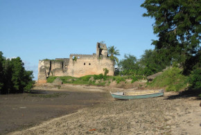
Written by Marco Ramerini. Photos by Alan Sutton

Situated along the coast of Tanzania, Kilwa fort was built by the Portuguese in 1505 and was the first stone fort built by the Portuguese along the coast of East Africa. The construction of the fort was the work of the sailors and soldiers of the squadron of D. Francisco de Almeida, the first viceroy of Portuguese India. The fort was built soon after the conquest of the city of Kilwa (Quiloa), which took place on July 25, 1505. A few years later, in 1512, the Portuguese abandoned the fortress.

Today the remains of the fortress are made up of a small square fortification of about 20 meters on each side, the side facing the land is the best preserved, while the side towards the sea was largely destroyed in recent years. The fort still maintains two towers at its corners to the land side, while on the sea side, there are only a few remains of a tower and a bastion.

Entrance Gate, Portuguese Fort, Kilwa, Tanzania. Author and Copyright Alan Sutton...
Entrance Gate, Portuguese Fort, Kilwa, Tanzania. Author and Copyright Alan Sutton…

The fort of Kilwa Kisiwani is on the UNESCO World Heritage list since 1981.

Inscription criteria: Ruins of Kilwa Kisiwani and Ruins of Songo Mnara. The remains of two great East African ports admired by early European explorers are situated on two small islands near the coast. From the 13th to the 16th century, the merchants of Kilwa dealt in gold, silver, pearls, perfumes, Arabian crockery, Persian earthenware and Chinese porcelain; much of the trade in the Indian Ocean thus passed through their hands.

In 2004 it was inscribed on the List of World Heritage in Danger.

[divider]

[divider]

BIBLIOGRAPHY:

– Various Authors “People of Zanzibar: The Portuguese period. The Portuguese legacy” Internet article.

– Various Authors “Documentos sobre os portugueses em Moçambique e na Africa central, 1497-1840. Documents on the Portuguese in Mozambique and Central Africa, 1497-1840” National Archives of Rhodesia and Nyasaland, Centro de Estudos Históricos Ultramarinos, 1962-(1989), Lisboa. Includes indexes. “The sources have been drawn from archives and libraries in Portugal, Italy, France and other countries … Published in the original with an English translation. Contents: v. 1. 1497-1506.–v. 2. 1507-1510.–v. 3. 1511-1514.–v. 4. 1515-1516.–v. 5. 1517-1518.–v. 6. 1519-1537.–v. 7. 1540-1560.–v. 8. 1561-1588.–v. 9. 1589-1615.

– Axelson, Eric “South-East Africa, 1488-1530” 306 pp. 1940, JLondon, UK. – Axelson, Eric “Portuguese in South-East Africa, 1488-1600” 276 pp. Struik, 1973, Cape Town, S.A.

– Axelson, Eric “Portuguese in South-East Africa, 1600-1700” x + 226 pp. Witwatersrand University Press, 1969, Johannesburg, S.A.

– Boxer, Ch. R. “Moçambique island and the Carreira da India” In STUDIA N° 8, pp. 95 – 132, 1961, Lisbon, Portugal.

– Freeman-Grenville, G. S. P. “The Portuguese on the Swahili Coast: buildings and language” In STUDIA N° 49, pp. 235-253, 1989, Lisbon, Portugal.

– Freeman-Grenville, G. S. P. “The French At Kilwa Island: an episode in eighteenth- century East African History” Clarendon press, 1965, 243 pages plus illustrations.

– Gray, J. “Early Portuguese Missionaries in East Africa” 53 pp. illus, map Macmilland and Co., 1958. – Gray, Sir John “Visit of French Ship to Kilwa in 1527” Paper. Off Print edition.

– Pearson,M.N. “Port cities and intruders: the Swahili Coast, India and Portugal in the Early Modern Era”202 pp. 2 maps, The Johns Hopkins University Press, 1998, Baltimore and London. Index: The Swahili coast and the Afrasian sea; the Swahili coast and the interior; East Africa in the world-economy; the Portuguese on the coast.

– Penrad, J. C. “O encontros dos mundos. Islamismo, redesde confrarias e competiçao na Africa Oriental” In: “Oceanos” n° 34; Apr/Jun. 1998; pp. 132-140

– Rajab al Zinjibari, Khatib M. “Islam and the Catholic crusade movement in Zanzibar” Index: Pre-Islamic era in Zanzibar; from Ethiopia to Zanzibar; Zanzibar in Muslim historiography; the origins of crusade in Zanzibar; the Portuguese motive in Zanzibar; Zanzibar Jihad for protection; Portuguese legacy in Zanzibar; Muslim liberation and Islamic revivalism.

– Strandes, J. “The Portuguese period in East Africa” xii, 325 pp., 5 plates, folding map, Edited by J. S. Kirkman, 1968, Nairobi, Kenya.

Categories
Dutch Colonialism South Africa

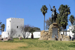
The Castle of Good Hope: A Dutch Fort in South Africa

Written by Marco Ramerini. English text revision by Dietrich Köster.

The Castle of Good Hope (Kasteel de Goede Hoop) is the oldest building in South Africa, it was built by the Dutch East India Company (VOC, Vereenigde Oost-Indische Compagnie) between 1666 and 1679; it was built in stone in substitution of a first wooden fort which was built in 1652 by Jan van Riebeeck, who commanded the Dutch expedition who founded Cape Town. The Riebeeck fleet consisted of five ships equipped by the Dutch East India Company (VOC) to establish a permanent settlement near the Cape of Good Hope, placed strategically along the route to the islands of Spices, so that they can supply ships along the crossing that led from Europe in the East.

Katbalkon, Castle of Good Hope (Kasteel de Goede Hoop), Cape Town, South Africa. Author and Copyright Marco

The Castle of Good Hope, an imposing stone building, was built along the ancient coastline, the works began in 1666, the first stone was laid on January 2, 1666, under the command of Zacharius Wagenaer and lasted until 1679. The castle has a pentagonal plan a five-pointed star, with moat and bastions at each corner, the five bastions were called Leerdam, Buuren, Katzenellenbogen, Nassau and Oranje, the original entrance was on the sea side, but in 1682 was decided to close the old entry and the current gate was open, above which was built, in 1684, the tower, which houses a bell of 1697.

Inside the castle were built a church, a bakery, some laboratories, shops, quarters for the soldiers of the garrison, the residence of the governor and prisons, the castle is divided into two main courtyards. In 1695, the Katbalkon was built, in the center of the old residence of the governor, which was renovated, designed by Louis Michel Thibault, between 1786 and 1790, it is a kind of podium balcony, where the governor used to make announcements to soldiers or citizenship.

Leerdam bastion and the entrance gate to the Castle of Good Hope (Kasteel de Goede Hoop), Cape Town, South Africa. Author and Copyright Marco

Today, the castle houses inside many attractions: the William Fehr Collection, in the palace of the governor, exposes antique furniture and paintings of the Dutch period. The Military Museum (Castle Military Museum) shows the military history of the castle and the history of the Cape colony. Inside the castle are also a restaurant and a bar. Every day at 10 am and 12 am, the castle guard performs the ceremony of the keys, which represents the opening of the castle, at the end of the ceremony is fired a gunshot.

Opening time: Open daily from 9.00 am to 16.00 pm. Closed December 25 and January 1. Tickets: Adults R20.00; Seniors R15.00; Students R10.00; Children R10.00; Half price on Sundays. 

[divider]

[divider]

[divider]

BIBLIOGRAPHY:

– Guelke, Leonard “Freehold farmers and frontier settlers, 1675-1780” In: “An Expanding World” Vol. n° 4; Disney, A. “Historiorgraphy of Europeans in Africa and Asia 1450-1800” Ashgate Variorum, vol. n° 4, 1995; pp. 174-216 Also in: “The shaping of South African Society 1652-1840” 1986, Middelton, Connecticut, USA, pp. 66-108

– Guelke, Leonard “The anatomy of a colonial settler population: Cape Colony, 1657-1750” In: “An Expanding World” Vol. n° 29; Nizza da Silva, M. B. “Historiorgraphy of Europeans in Africa and Asia 1500-1800” Ashgate Variorum, vol. n° 29, 1998; pp. 293-313 Also in: “International Journal of African Historical Studies” Vol. 21, n° 3 1988, Boston, MA, USA, pp. 453-473

– Raven-Hart, R. “Cape of Good Hope 1652-1702. The first fifty years of Dutch colonisation as seen by callers” ? 2 vols Vol. I: xvi+222 pp. with 28 b/w illust. Vol. II: xii+303 pp. with 37 b/w illust. A. A. Balkema, 1971, Cape Town, South Africa. 103 accounts by visitors to the Cape between 1652 and 1702, taken from the original Dutch, English, French, Portuguese, Danish and German. The Foundations 1652-1662. Too many Cooks 1663-1679. Expansion and Exploration 1680-1698. Greed and Graft 1699-1702.

– Sleigh, D. “The Forts of the Liesbeeck Frontier” Castle Military Museum, Cape Town, South Africa. [The South African Military History Society]

– Theal, G. “The history of South Africa under the administration of the Dutch East India Company (1652 – 1795)” 459+462 pp. maps, 2 voll. Swan Sonnenschein & Co., 1897, London, United Kingdom.

Categories
Dutch Colonialism South Africa

The Dutch in South Africa, 1652-1795 and 1802-1806

Written by Marco Ramerini. English text revision by Dietrich Köster.

The Dutch settlement history in South Africa began in March 1647 with the shipwreck of the Dutch ship Nieuwe Haarlem. The shipwreck victims built a small fort named “Sand Fort of the Cape of Good Hope”. They stayed for nearly one year at the Cape. Finally they were rescued by a fleet of 12 ships under the command of W.G. de Jong. On one of these ships was Jan van Riebeeck, too.

After their return to Holland a part of the shipwrecked tried to persuade the Dutch East India Company to open a trading center at the Cape. In 1652 a Dutch expedition of 90 Calvinist settlers under the command of Jan Van Riebeeck founded the first permanent settlement near the Cape of Good Hope. They arrived in the bay of today’s Cape Town – later named Table Bay/Tafelbaai – on 6 April 1652 on board of five ships: the “Reijger”, the “Oliphant”, the “Goede Hoop”, the “Walvisch” and the “Drommedaris”.

A square wooden fort with four bastions was quickly built on the left bank of the Salt River, where is now the Central Post Office, and later were built also two redoubts near the shore. They were named “Kyckuit” and “Duinhoop”. In 1666 the first stone was laid on 2 January and the original fort was replaced by a new stone fort named Castle of Good Hope/Kasteel de Goede Hoop, a massive pentagonal fortress with a moat and bastions at each corner. The bastions were named: “Nassau”, “Leerdam”, “Oranje”, “Catzenellenbogen” and “Buuren”.

Paarl, South Africa. Author and Copyright Marco Ramerini

As Prof. Ch. R. Boxer wrote in his book “The Dutch seaborne Empire”, “the Cape developed into a colony, which was something unique, save for the short-lived New Netherland, in the possesion of the Dutch East and West India Companies. It had a healthy, subtropical and partly fertile hinterland, which was virtually unoccupied. White colonisation was as feasible here as it had been in New Netherland, with the additional advantage that there was no rival European nation close at hand.”

On 3 June 1652 the first child was born. The development of a community of free-burghers was the main secret of the success of the settlement. From the beginning the first trades with the Hottentots were started being residents of the zone, but the relationship with these tribes were often problematic. In 1655 the first coast vessel made of Cape timber was lauched. In 1657 two groups of farmers settled about three miles from the castle at Groenevelt (or Dutch Garden) and Rondebosch. In 1658 the population of the whole Cape Colony consisted of 162 persons, slaves included. In 1659 wine was pressed from Cape grapes for the first time.

Stellenbosch, South Africa. Author and Copyright Marco Ramerini.

During the first years the natives were the most persistent problem of the colony. They frequently stole cattle. To solve the problem it was decided to build a strong fence around the farms to protect the cattle. These defences were extended from Blaauwberg across the bay to Salt River and then through Groote Schuur to the hill of Wynberg. Three watch-houses were also built. The whole settlement was thus protected from Hottentot incursion. Saldanha Bay, Dassen Island and Robben Island were developed as outposts of trade and stock raising. In 1660 a Dutch ship with 150 slaves from Angola arrived at the Cape. Later the same year another ship arrived with more slaves. Thus the number of slaves in the settlement rose to 187. A school was opened to teach Dutch and religion to the children of the white settlers and to the Mulattos and Hottentots, too.

When Jan van Riebeeck laid down his office in May 1662, there were 39 free farmers, of whom 15 were married. Free labourers employed on the farms amounted to 54. The whole farming community was of some 130 persons, besides the servants and the officials of the VOC. After the departure of Jan van Riebeeck a period of confusion began in the colony: During the first ten years 4 governors were appointed and after this started the war with France.

[divider]

[divider]

Castle of Good Hope (Kasteel de Goede Hoop), Cape Town, South Africa. Author and Copyright Marco...
Castle of Good Hope (Kasteel de Goede Hoop), Cape Town, South Africa. Author and Copyright Marco

On 2 Janaury 1666 during the government of Wagenaer was laid the foundation stone of the Castle of Good Hope, which was completed in 1674 during the government of Isbrand Goske. In 1672 the white population was less than 600 souls, of whom only 64 were male free-burghers. On 9 April 1678 was laid the first stone of the Dutch Reformed Church of Cape Town. This building was completed 25 years later.

In 1679 the colony had 289 Europeans of whom 142 were free-burghers and 191 slaves. As in Ceylon the free-burghers in Kaapstad (Cape Town) were in most cases tavern-keepers or to a lesser extent craftsmen and shopkeepers. In this year a new governor was appointed. He was the Mauritius-born Simon van der Stel. In the first year of his government he founded Stellenbosch, the second oldest town in South Africa, and during the twenty years of his government he promoted the immigration of new families from The Netherlands, built a new hospital and thoroughly developed the colony.

The Dutch settlements in South Africa 1652-1795 and 1802-1806. Author and Copyright Marco Ramerini

In 1688 a group of about 200 French Huguenots arrived. They settled in Stellenbosch, Drakenstein, Paarl and Franschhoek, developing farming and in particular vineyards. In 1691 the population of Kaapstad or “De Kaap” consisted of 1000 Europeans and 400 Slaves. In 1695 there were still only 340 free-burghers in the colony.

In February 1699 Simon van der Stel handed over the government to his son Willem Adriaan van der Stel. During his administration he had several problems with the French Huguenot settlers. During the administration of Maurice de Chavonnes (1714-1724) a series of small outposts were built at strategic points in Tulbagh, Klapmuts, Groenekloof and Saldanha Baai to prevent Hottentot raids.

In 1717 there were more than 5,000 souls, of whom 2,500 were Europeans in the colony (in most cases farmers and breeders) and 2,500 slaves.

[divider]

The growth of the population in Dutch South Africa

Year Whites Free Burghers + Servants Slaves Total Whites +Slaves Free Burghers Soldiers Total Whites +Slaves +Soldiers
1652 90 0 90
1658 82 80 162
1660 187
1672 221 200 421 64
1679 289 191 480 142
1685 200
1691 1.000 400 1.400
1695 340
1699 1.232 536 1.768 414 751      2.519
1717 2.500 2.500 5.000 2.000         
1733 2.598 2.218 4.816
1756 5.000
1780 12.000
1795 16.000 16.839 32.839

[divider]

In 1720 the Breede and Oliphant’s valleys were populated. Jan de la Fontaine became governor in 1724 and he was in control of the Cape Colony until 1739, except for an interval of three years, when Gysbert Noodt was governor. La Fontaine was a quietly efficient governor. In 1730 the Little Karoo valley was reached and in 1734 he started to colonize the Mossel Baai area.

The first governor born in the Cape was appointed in 1739. He was Henry Swellengrebel. His name has been preserved in the town of Swellendam, which was founded during his government. During the government of Ryk Tulbagh (1751-1771) the Orange River was reached. In these years the French astronomer Abbé de la Caille made a chart and a catalogue of the sky of the Southern Hemisphere in Kaapstad. During the Tulbagh successor, Joachim van Plettenberg (1771-1785), the exploration of the Orange River valley was completed. Van Plettenberg was a capable and energetic governor.

In 1780 there were 11,000-12,000 free-burghers, of whom at least 3,000 lived in Kaapstad. The Boers in the late 18th century regarded South Africa as their fatherland. In 1785 a new governor was appointed: He was van de Graaff. During his administration the town of Graaff-Reinet was founded. Kaapstad was now a town of 4,300 settlers without counting blacks and sailors. Stellenbosch was the foremost farming settlement.

In 1794 the Dutch East India Company went bankrupt and in 1795 the British seized the colony. The Dutch surrender in 1795 is known as the Capitulation of Rustenburg. In 1795 the town of Kaapstad had 14,021 inhabitants, of whom 4,357 were Europeans. In 1795 the slaves in the whole colony amounted to 16,839 and the Whites totalled nearly 16,000.

At the 1802 Treaty of Amiens the Netherlands (now Batavian Republic) recovered the colony. Jacob de Mist was appointed as new Dutch governor. After three years of government he handed the command over to John Williams Janssens. On 18 Janaury 1806 he surrendered the colony to the British at Blaauwberg.

[divider]

CAPE GOVERNORS

YEARS

Jan van Riebeeck 1652-1662
Zacharias Wagenaer 1662-1666
Cornelis van Quaelberg 1666-1668
Jacob Borghost 1668 -1670
Peter Hackius 1670-1671
Albert van Breughel act. 1671-1672
Isbrand Goske 1672-1676
Johann Bax van Herentals 1676-1679
Simon van der Stel 1679-1699
William Adrian van der Stel 1699-1708
Louis van Assenberg 1708-1713
Maurice de Chavonnes 1714-1724
Jan de la Fontaine act. 1724-1726
Gysbert Noodt 1726-1729
Jan de la Fontaine

1729-1739

Adrian van Kervel

1739 for3 weeks

Henry Swellengrebel 1739-1751
Ryk Tulbagh 1751-1771
Joachim van Plettemberg 1771-1785
van de Graaff 1785-1791
John Reinus act. 1791-1793
Abraham Sluysken 1793-1795
English occupation 1795-1802
Jacob de Mist act. 1802-1805
John Williams Janssens 1805-1806

[divider]

[divider]

BIBLIOGRAPHY:

– Guelke, Leonard “Freehold farmers and frontier settlers, 1675-1780” In: “An Expanding World” Vol. n° 4; Disney, A. “Historiorgraphy of Europeans in Africa and Asia 1450-1800” Ashgate Variorum, vol. n° 4, 1995; pp. 174-216 Also in: “The shaping of South African Society 1652-1840” 1986, Middelton, Connecticut, USA, pp. 66-108

– Guelke, Leonard “The anatomy of a colonial settler population: Cape Colony, 1657-1750” In: “An Expanding World” Vol. n° 29; Nizza da Silva, M. B. “Historiorgraphy of Europeans in Africa and Asia 1500-1800” Ashgate Variorum, vol. n° 29, 1998; pp. 293-313 Also in: “International Journal of African Historical Studies” Vol. 21, n° 3 1988, Boston, MA, USA, pp. 453-473

– Raven-Hart, R. “Cape of Good Hope 1652-1702. The first fifty years of Dutch colonisation as seen by callers” 2 vols Vol. I: xvi+222 pp. with 28 b/w illust. Vol. II: xii+303 pp. with 37 b/w illust. A. A. Balkema, 1971, Cape Town, South Africa. 103 accounts by visitors to the Cape between 1652 and 1702, taken from the original Dutch, English, French, Portuguese, Danish and German. The Foundations 1652-1662. Too many Cooks 1663-1679. Expansion and Exploration 1680-1698. Greed and Graft 1699-1702.

– Sleigh, D. “The Forts of the Liesbeeck Frontier” Castle Military Museum, Cape Town, South Africa. [The South African Military History Society]

– Theal, G. “The history of South Africa under the administration of the Dutch East India Company (1652 – 1795)” 459+462 pp. maps, 2 voll. Swan Sonnenschein & Co., 1897, London, United Kingdom.

Categories
Dutch Colonialism South Africa

The Dutch Heritage in South Africa: the Afrikaans Language and the Dutch Reformed Church

Written by Marco Ramerini. English text revision by Dietrich Köster.

THE AFRIKAANS LANGUAGE

Afrikaans is a language of Dutch origin and structure similar to Flemish; it’s also influenced by various African languages and by Portuguese, German, French and Malay. Afrikaans was declared an official tongue of South Africa besides English in 1925.

Afrikaans is not only spoken by the White peoples of Dutch, Huguenot and German descent (about 60% of South Africa’s Whites), but also by the majority (about 90%) of the people of mixed descent (Coloureds). Today (2001 census) Afrikaans is the 3rd language of South Africa. 5,983,426 are Afrikaans first language speakers in South Africa, 146,000 in Namibia and 20,000 in Botswana. About 4,000,000 use Afrikaans as second or third language in South Africa.

According to the South African Census 2001, Afrikaans is the majority language in Western Cape province (2,500,748 speakers) and Northern Cape province (559,189 speakers) it’s the second language in Eastern Cape province (600,057 speakers), in Free State province (323,082 speakers), in Gauteng province (1,269,176 speakers), in North West province (275,681 speakers); there is a large number of speakers also in the other provinces: Kwa-zulu Natal (140,833 speakers, 4th), Limpopo (122,531 speakers, 4th) and Mpumalanga (192,129 speakers, 5th).

The Afrikaans Language Monument in Paarl. Author and Copyright Marco Ramerini

Afrikaans variants are: Cape Afrikaans (West Cape Afrikaans), Orange River Afrikaans and East Cape Afrikaans. Afrikaans Creole languages are: Oorlams and Flaai Taal.

The Afrikaaners/Afrikaners (Boers) have a rich mix of cultures in their blood: one estimate shows 40% Dutch, 40% German, 7.5% British (mainly Scots), 7.5% French and 5% others. These terms were first used in 1707.

According to the Namibian census 2001 the Afrikaans language is the second language of Namibia (11% of the total population). It’s the majority language in Karas region (40%) and in Hardap region (44%); it’s the second language in Erongo region (22%) and in Khomas Region (24%); it’s the third language in Omaheke Region (12%).

THE REFORMED CHURCH

The Reformed Church or Gereformeerde Kerk consists of three related churches, which according to a census represent more than 3,000,000 people. The Nederduitse Gereformeerde Kerk (NGK) is the largest of the three churches and has now more than 1,200 congregations and 1,300,000 members. The two smaller Reformed Churches are the Nederduitsche Hervormde Kerk and the Gereformeerde Kerk, which form part of the Afrikaans-language churches.

The other churches are the Uniting Reformed Church in Southern Africa, which is the result of the merging in April 1994 of:

– Nederduitse Gereformeerde Sendingkerk, (traditionally the church of the coloured people)

– Nederduitse Gereformeerde Kerk in Afrika, (traditionally black people)

– Indian Reformed Church in Africa, (with predominantly Indian members)

Today the Dutch Reformed Church has also six English-language congregations. There is also one congregation for Dutch-speaking people and four for Portuguese speakers. In total there are about 2,000 members in these congregations.

SOUTH AFRICA STATISTICS:

In the 2001 census South Africa had 44,819,778 inhabitants of whom 35,416,166 were Bantus (Zulu, Sotho, Xhosa, Tswana, Tsonga, Swazi, Ndebele and others), 4,293,640 were Whites (mostly Boers and British), 3,994,505 were Coloureds (people of mixed descent mainly Whites and Hottentots, the latter also called Namas or Khoi Khois) and 1,115,467 were Asians (mostly Indians, a few Chinese).

A more recent estimate (2005) of the South African population gives a total of 46,888,200 inhabitants of whom: African 37,205,700 (79,4%), White 4,379,800 (9,3%), Coloured 4,148,800 (8,8%) and Asian 1,153,900 (2,5%).

Mid-year 2007 estimate: Total 47,850,700: African 38,079,900 (79,6%), White 4,352,100 (9,1%), Coloured 4,245,000 (8,9%) and Asian 1,173,700 (2,5%).

Mid-year 2011 estimate: Total 50,586,757: African 40,206,275 (79,5%), White 4,565,825 (9,0%), Coloured 4,539,790 (9,0%) and Asian 1,274,867 (2,5%).

[divider]

[divider]

BIBLIOGRAPHY:

– Elphick, R., and Hermann Giliomee “The Shaping of South African Society, 1652-1820” ? 1979, Cape Town and London.

– Gerstner, J. Neil “The thousand generation covenant : Dutch Reformed covenant theology and group identity in colonial South Africa, 1652-1814” ? XI, 280 pp. E. J. Brill, 1991, Leiden, NL. A historical study of the role of theological concepts in the development of Afrikaner group identity during the period when South Africa was a Dutch colony.

– Guelke, Leonard “Freehold farmers and frontier settlers, 1675-1780” In: “An Expanding World” Vol. n° 4; Disney, A. “Historiorgraphy of Europeans in Africa and Asia 1450-1800” Ashgate Variorum, vol. n° 4, 1995; pp. 174-216 Also in: “The shaping of South African Society 1652-1840” 1986, Middelton, Connecticut, USA, pp. 66-108

– Guelke, Leonard “The anatomy of a colonial settler population: Cape Colony, 1657-1750” In: “An Expanding World” Vol. n° 29; Nizza da Silva, M. B. “Historiorgraphy of Europeans in Africa and Asia 1500-1800” Ashgate Variorum, vol. n° 29, 1998; pp. 293-313 Also in: “International Journal of African Historical Studies” Vol. 21, n° 3 1988, Boston, MA, USA, pp. 453-473

– Marais, Johannes Stephanus “The Cape Coloured People, 1652-1937” ? 296 p. Longmans 1939 London (reprint Witwatersrand University Press : 1957, 1968, 1978)

– Mc Carter, J. “The Dutch Reformed Church in South Africa. With Notices of the Other Denominations. An Historical Sketch” ? 152 pp. with 2 lithograph plates, W & C Inglis, 1869. A historical sketch of the development of the church under VOC and British rule its schisms and dissidents, as well as short data on other churches in the territory.

– Schutte, Gerrit “Between Amsterdam and Batavia: Cape society and the Calvinist church under the Dutch East India Company” ? In: “Kronos, Journal of Cape History” n° 25, 1998/1999

– Theal, G. “The history of South Africa under the administration of the Dutch East India Company (1652 – 1795)” 459+462 pp. maps, 2 voll. Swan Sonnenschein & Co., 1897, London, United Kingdom.

– Trotter, A. F. “Old Cape Colony: a Chronicle of Her Men and Houses from 1652 to 1806.” ??? 320 pp. illustrations throughout, County Library series No.II. Selwyn & Blount, 1903

– Worden, N. – Van Heyningen, E. – Bickford-Smith, V. “Cape town: the making of a city. An illustrated social history (under Dutch and British rule) ? 283 pp. with many illustrations. 1998, Hilversum. Beginning in the 17th century with the tiny Dutch settlement, the book charts the growth of Cape Town over almost three centuries, ending with the British colonial city.

Categories
Portuguese Colonialism São Tomé and Principe

The Fortress of Santo António da Ponta da Mina, Principe Island

Written by Marco Ramerini, photos and information by James Leese. English text revision by Dietrich Köster.

According to a source dated 1815, this was the situation of the Portuguese forts on the island of Príncipe, in particular in the Bay of San António, where almost all the boats anchored: the two main defenses of the bay were the fortress of Ponta da Mina and the fortress of Santa Ana.

The fortress Ponta da Mina was built on a promontory that forms the southern tip of the port, the importance of this fortification was essential, because nearby were passing and were at anchor the ships arriving in port. From the fortress of Ponta da Mina, which was composed of two batteries (“Bateria Real” and “Bateria do Príncipe”), of which depended the Redoubt “Nazareth”, the low stronghold “Praça Baixa de Nossa Senhora” and the battery “São João”.

The fortress consisted of two batteries, the “Bateria Real”, which was the upper one and the “Bateria do Príncipe” located further down. The “Bateria Real” was situated very high above the harbor about 500 feet high, its shape was semicircular with the convex side facing the sea, it was armed with 16 pieces of bronze artillery of various calibers (from 3 to 14), there was also a small depot of gunpowder and on high ground was the place of residence of the garrison, besides this was a round shaped depot of gunpowder (like a windmill) and of poor construction.

Gateway to the Lower Fort, Fortaleza da Ponta da Mina, Príncipe island. Author and Copyright James Leese

The “Bateria do Príncipe” was west of the “Bateria Real” and was reached by a path that went down in a zig-zag starting from the “Bateria Real”. The “Bateria do Príncipe” was the most important for the defense of the port, because it was only 200 feet above sea level, it was a square shaped and made of stone and lime, 33 palms large and 120 palms long, the height of the inside wall was 9 palms, on the north side were five iron pieces of artillery with a caliber of 6, on the west side were two pieces of the same caliber, and on the south side was a single piece of caliber 4, while in the east was the mountain with the “Bateria Real”.

At 50 toezas east of the “Bateria Real” and on a height of 35 feet above the sea was the redoubt called “Praça Baixa de Nossa Senhora”, this fortification had three pieces of iron artillery of caliber 3 and it was very important for the defense of the port.

Lower Fort, Fortaleza da Ponta da Mina, Príncipe island. Author and Copyright James Leese

On a nearby hill overlooking the fortress of Ponta da Mina on the southwest side (“sudoeste”) was a redoubt called “Nossa Senhora da Nazareth”, who is described as the most interesting military work of the island of Príncipe. It was because of this lack that the French easily conquered the island in 1706 and 1709. The redoubt had two bronze cannons with a caliber of 4 and a moat with a drawbridge.

This redoubt controls all the fortifications of the island: only a shot of espingarda away were the “Bateria Real”, the “Bateria do Príncipe” and the “Praça Baixa de Nossa Senhora”.

A shot of espingarda to the west (“oeste”) from the fortress of Ponta da Mina was another battery called São João, where there were two iron cannons with a caliber of 6.

Canons of Ponta da Mina, Fortaleza da Ponta da Mina, Príncipe island. Author and Copyright James Leese

This description corresponds with what was found by James Leese, who is studying the fortifications of the island. The fort of Ponta da Mina was the main fort of the area and served as the main defense on the sea side, another fort was on the opposite side of the bay at Ponta Santana (Santa Ana). The place was visited by James Leese, and currently there are only visible remains of a stone wall. To confirm the existence of a fort on the Ponta de Santana there is the testimony of some locals that some guns were found on this site.

On the site indicated by the map as Ponta Forte, James Leese has found remains, he presumed to be the premises of a garrison, although there are clear traces that the area was used for the processing of cocoa. During the research in the area of the fort of Ponta da Mina 34 iron guns were found, some of which are ship guns.

[divider]

[divider]

BIBLIOGRAPHY:

– José Brandão Pereira de Melo “A fortaleza de Santo António da Ponta da Mina na Ilha do Príncipe” 1943

– James Leese “e-mail” to me in 2005 and 2006

Categories
Portuguese Colonialism São Tomé and Principe

The revolt of the slaves on the African island of São Tomé 1595

Written by Marco Ramerini. English text revision by Dietrich Köster.

The revolt of Amador, named after the slave who led it, is the most important attempt of rebellion that has ever happened on the island of São Tomé. The revolt of the slaves of the island began on July 9, 1595. The leader of this revolt was from the beginning a black slave named Amador (who was owned by Bernardo Vieira).

The first group of rebels, which amounted to about 200 people attacked the church of Santa Trindade, a parish outside the city, where they killed some whites who were in the church while waiting for the Mass. In the days following this first event the revolt spread and many sugar factories and farms in the areas of Dalengue, Uba Ubundo and Praia Preta were burnt by rioters.

On 11 July 1595 the rebels attacked the city, where in the old market an indecisive battle with the Portuguese took place. The next day they burnt sugar factories and other farms in the areas of Água, Sabão and Dalhmanhe. The number of rebels had continued to increase. The sources report of around 2,000 people in their ranks.

On 14 July there was a great battle near the town that ended with the withdrawal of the rebels, who were defeated and suffered heavy losses. According to sources out of 800 attacking rebels more than 300 were killed. Despite this heavy defeat the rebels did not give up as losers. They divided their forces and attempted to attack the city from several sides. But this attempt also failed prompting an intervention by the Portuguese.

The rebels, however, continued to keep the city under siege. On 23 July the Portuguese attempted a break-out to remove the siege. This action provoked a harsh reaction from the rebels, who tried in the days following the final conquest of the city. The battle that decided the fate of the rebellion began at dawn on 28 July 1595, when 5,000 rebels stormed the city.

The attack lasted about four hours. The attackers, who were in superior numbers compared to the defenders, however, were rejected by the artillery and the trenches that in the meantime the Portuguese had built. According to documents the rebels lost 200 to 500 men in the clash. But the most important thing that they lost was the belief of being able to continue the revolt successfully. The very next day there were the first defections in the ranks of the rebels. In a short time about 4,000 rebels asked for forgiveness, leaving the leader of the revolt Amador only with a few diehards behind. He took refuge in the forest, but was captured in mid-August and then killed. The revolt left the island’s economy devastated. It seems that a total of about 60 sugar factories were destroyed.

BIBLIOGRAPHY:

Source of this story is the story of the revolt of Amador narrated by Father Manuel de Rosario Pinto in chapter XXV of his “Historia da Ilha de São Tomé” in 1732 and published on pages 304-310 of Appendix II of the book by Robert Garfield “A history of São Tomé Island, 1470-1655. The key to Guinea” San Francisco, 1992.

Categories
Dutch Colonialism Portuguese Colonialism São Tomé and Principe

The Dutch on São Tomé and Principe: the attacks on the island of Principe (1598) and São Tomé (1599)

Written by Marco Ramerini. English text revision by Dietrich Köster.

Shortly after the Union of Spain and Portugal, Philip II imposed the ban on the Dutch to trade and use the Iberian ports, this act was the result of the Dutch rebellion against the Spanish king, and it suddenly kept the Dutch away from the supply of goods from the rich colonies of these two countries.

Philip II believed by doing so he would give a final and hard blow to the ambitions of the Dutch, but the ban had the opposite effect. In fact the Dutch traders were encouraged to attack the overseas possessions of the Iberian monarchy in order to bypass the blockade imposed on them and with the risky but ambitious goal of controlling the commercial overseas market themselves instead of their enemy Philip II.

Owing to this fact the first Dutch expeditions along the coast of the Gulf of Guinea took place. In 1596 an expedition equipped by the Zeeland commercial house Moucheron attacked, without success, the Castle of São Jorge da Mina on the Gold Coast (now Ghana), being the main base of the Portuguese in the area.

The Dutch traders, who had begun to frequent the area of the Gulf of Guinea, making fierce competition to the Portuguese traders, were able to exclude them from trade in gold, ivory, wax and pepper after about 15 years. Only the slave trade was for the time being under the control of the Portuguese, but only because the Dutch were not interested in this trade at that time.

Portuguese Fort São Sebastião, São Tomé, São Tomé e Príncipe

The Dutch, after the failed attack on the main Portuguese fort of São Jorge da Mina, thought that the island of Príncipe could be a useful base of support in the area, and organized for this purpose an expedition against the island.

Even this expedition was sent by the commercial Zeelandese house Moucheron, which saw the conquest of the island of Príncipe as a springboard for further expansion in the Gulf of Guinea and the next possible conquest of the rich sugar island of São Tomé, which was the main objective. According to these plans a fortress was to be built on the island of Príncipe.

The expedition, which consisted of five ships under the command of Cornelis van Moucheron, arrived on Príncipe island in August 1598 and with a surprise attack the Dutch occupied the island. Once occupied the island, the necessary construction material for the fortress was brought ashore. It had been specially brought along from Holland. Under the command of Cornelis van Moucheron, who was appointed governor of the island, had begun the construction work. Unfortunately for the Dutch, who apparently were rather unfamiliar with the area: The rainy season had begun. This led to unhealthy air. So many men of the expedition became ill and some died of marshfever. The bad weather and attacks from the Portuguese of São Tomé forced the Dutch to abandon the island of Príncipe after about three months of occupation.

Despite this fiasco the following year in October 1599 a new larger expedition arrived this time on the island of São Tomé. The new navy force was composed of 36/40 ships commanded by Pieter van der Does. Partly it was equipped by Moucheron, too.

São Tomé was defended by a militia formed by the inhabitants and slaves and by a small fort, Fort São Sebastião that could not provide adequate protection to the people and the city, it was equipped with little artillery, only six small guns and two mortars, had little gunpowder and lacked a garrison of professionals. According to Portuguese sources the only professional soldier of the entire island was a sergeant-major.

On 18 October 1599, early in the morning, the Dutch fleet came in sight of São Tomé, despite the fact that the Portuguese had known for a few weeks of the arrival of the Dutch fleet it seems that little had been done to improve the island’s defenses. Dutch ships arrived in the port and began to bombard the city. By mid-morning it was evacuated by the Portuguese, who hid inside the island. But a small contingent of about 20 people – including the Portuguese governor Fernando de Meneses – were trapped in the fort resisting the Dutch for another three hours and then surrendered. Finally the Dutch took over the fort.

Meanwhile the Portuguese fled from the city, got reorganized under the command of João Barbosa da Cunha and tried a counterattack on October 20. According to Portuguese sources the attack was done to force the Dutch to withdraw. On the other hand according to Dutch sources the reason for the failure of the Dutch expedition was to be found in the unhealthy climate of São Tomé. In fact also this time the Dutch had chosen the most unfavourable season being the beginning of the rainy season (lasting from October to June) with regular equatorial rains, which caused disease among the Dutch troops. In a few days about 1,200 men died, including the commander of the expedition Pieter van der Does. After two weeks the rest of the expedition abandoned São Tomé, but not before setting fire to the town and having pillaged and destroyed the fort and burned churches and farms of the island.

The Dutch attack was a blow to the island’s economy, because it was preceded by some events that had already undermined the prosperity of the island: in 1574 there was an onslaught of “Angolares”¹ against the north of the island, when several sugar cane plantations and many farms were destroyed. In 1585 a fire devastated the city of São Tomé and in July-August 1595 a major slave revolt occurred, which was led by a certain Amador, who set fire to the island for several weeks.

End of part one. Soon to be followed by a second part.

NOTES: ¹Angolares: Bantu Negro race, coming from Angola, who lived in the forests and mountains in the south of the island. There are several theories about their origin: some say it were black slaves who had escaped from the plantations, but others argued that they were slaves on board a slave ship wrecked off the coast of the island and who had managed to escape from the wreck, then there are those who think that they were the first settlers, who had reached the island before the arrival of the Portuguese.

BIBLIOGRAPHY:

– Garfield, Robert “A history of São Tomé Island, 1470-1655. The key to Guinea” San Francisco, 1992

– Ratelband, Klaas “Nederlanders in West-Afrika (1600-1650). Angola, Kongo en São Tomé” Portuguese edition: “Os Holandeses no Brasil e na costa africana. Angola, Congo e São Tomé (1600-1650)” Lisboa, 2003.

Categories
German Colonialism Namibia

The German Fort Alte Feste in Windhoek, Namibia

Written by Marco Ramerini. English text revision by Dietrich Köster.

The Alte Feste Fort was founded by the German commander Curt von François in 1890. He laid the foundation stone for the construction of the fort on 18 October 1890. It is therefore the oldest building in the city of Windhoek, the capital of Namibia.

The fort is located high on a hill overlooking the central area of Windhoek. The fort was originally rectangular-shaped, measuring 62 meters in length and 35 meters in width. At the corners were built four towers. The two on the eastern wall were 9 meters high and the two on the western wall measured 6 meters in height.

During the German colonial era the fort was used as a headquarters of the German colonial troops/Schutztruppe (until 1915) and then as a headquarters for the South African troops. In 1935 it became a hostel of the Windhoek High School (WHS).

The German fort Alte Feste, Windhoek, Namibia. Author and Copyright Marco Ramerini..
The German fort Alte Feste, Windhoek, Namibia. Author and Copyright Marco Ramerini.

In 1957 it was declared a national monument and since 1962 it hosts the State Historical Museum, a multipurpose museum, which contains information on the history of Namibia from its origins (the San/Bushmen art) to the colonial period and independence. Inside are exposed furniture, rock paintings, musical instruments, ceramics, objects of the colonial era and photographs of the struggle for the independence of Namibia.

Near the fort is located the equestrian monument called Reiterdenkmal, erected in 1912 to commemorate the German soldiers and civilians killed during the uprising of the Hereros and Namas (1903-1907 and 1908).

Categories
Dutch Colonialism Mauritius

The Dutch on Mauritius 1638-1658, 1664-1710

Written by Marco Ramerini. English text revision by Dietrich Köster.

Mauritius was discovered in 1505 by the Portuguese navigator Domingo Fernandez, who named it “Ilha do Cerne”, a corruption of Ilha do Cisne, meaning Swan Island. The Portuguese used the island as a fresh food reserve for the ships bound for India.

The first Dutchman visiting the island was Wybrant Warwijck in 1598, who renamed the island after the Dutch stadhouder Maurits. During the first 40 years of Dutch activity in the East, Mauritius was often used by the VOC ships in search of fresh food as a call station, but they never built during these years a permanent settlement.

The main natural resources of the island were ebony and wild animals like the notorious Dodo, pigs, goats and tortoises. In the 1630s the presence of a permanent Dutch settlement on Mauritius was judged necessary by the VOC to prevent the occupation of the island either by the French or by the English company.

Finally the Hollanders settled on the East coast of the island in the south-eastern harbour, which they called “Haven van Warwijck” or “Ooster Haven”, where the town of Vieux Grand Port now stands. Here in May 1638 they built a square-shaped wooden fort with bastions and cannons at each corner, which was named Fort Frederik Hendrik.

The Dutch settlements on Mauritius

This fort was garrisoned at first by a force of 25 Dutchmen under the command of the first governor: Cornelis Gooyer. The fort was finished on 29 August 1638.

In 1639 a new chief (“Opperhoofd”) was appointed. He was Adriaan van der Stel, the father of Simon, who should become famous as the first governor of the Cape of Good Hope. Simon van der Stel was born on Mauritius during his father’s government of the island.

van der Stel rebuilt the fort and armed it with 14 cannons. The garrison was enlarged to 80 men and the first slaves were imported from Madagascar. To develop this “trade” a Dutch factory was established in the Bay of Antongil (N-E Madagascar) in 1642. This factory was closed at the end of the year 1646. During the van der Stel government several attempts were made to develop agriculture (sugar cane, vegetables, fruit trees), but they all failed because of the rats.

In 1645 Adriaan van der Stel was transferred to Ceylon and Jacob van der Meersch became the new governor. During his government the woodcutting of ebony trees was developed and a five-kilometer road was built in Flacq to facilitate this activity and several burghers settled on the island. In 1655 during the government of Reiner Por there were in the three settlements of the island (Grand Port Bay, Flacq and Trou d’Eau Douce) 100 people, among them planters with their families and slaves and 60 VOC employees. A new attempt to introduce agriculture on a larger scale was made, but this time the cultivated area was again devastated by the rats. This was the coup de grâce to the weak economy of the island. In 1658 the VOC actually decided to abandon the island colony. The last “Opperhoofd” Abraham Evertsz destroyed Fort Frederik Hendrik in 1658 and abandoned Mauritius with the remaining 40 inhabitants.

Between 1658 and 1664 Mauritius was uninhabited except for some ship-wrecked sailors.

In 1663 the VOC ordered the governor of the Cape colony to reestablish the Dutch settlement on Mauritius. In the summer of 1664 a ship under the new governor Jacobus Nieuwlant anchored in the “Haven van Warwijck”, where the ruins of the old Fort Frederik Hendrik were still to be found. The Nieuwlant government was short. He died at the end of May 1665. George Wreede was appointed as “Opperhoofd”. He resumed the ebony cutting and attempts were made to develop farming.

After the death of Wreede in 1673 Hubert Hugo became “Opperhoofd”. He was an excellent commander. He developed farming, reconstructed the fort, built a new church, a saw mill, a tannery and 16 km of road in Flacq. The population of the island increased. The Burghers had spread over the island: in the present area of Flacq (the main settlement), in Black River and in Port Louis.

In 1677 Isaac Lamotius was appointed as new “Opperhoofd” of Fort Frederik Hendrik. The garrison had 55 soldiers and slaves and the Burghers were 32. During the Lamotius government (1677-1692) the last Dodos were killed, a flightless bird, which is endemic to the island.

In 1692 Roelof Diodati became “Opperhoofd”. He was of Swiss-Italian descent. In 1695 a big hurricane devastated the island. Several Burghers lost all their crops and many left the island.

In 1703 the last Dutch “Opperhoofd” of Mauritius was appointed: Adriaan Momber van der Velde. During his government the island economy experienced great misfortune and was reduced to extreme poverty. In 1706 the VOC finally decided to evacuate the island. At that time the Dutch population consisted of 48 VOC employees and 32 Burghers. 5 of the latter were living in Black River, 15 in the north-western harbour and 12 in Flacq. These Burghers had 24 wives and 69 children. There were also 71 slaves. Thus the population amounted to a total of 244 persons. In February 1710 the last Dutchman left Mauritius.

[divider]

OPPERHOOFDEN

YEARS

Cornelis Gooyer

1638-1639

Adriaan van der Stel

1639-1645

Jacob van der Meersch

1645-1648

Reiner Por

1648-1653

Maximiliaan de Jongh

1653-1656

Abraham Evertsz

1656-1658

NO DUTCH OCCUPATION

1658-1664

Jacobus van Nieuwlant

1664-1665

George Wreede

1665-1673

Hubert Hugo

1673-1677

Isaac Lamotius

1677-1692

Roelof Diodati

1692-1703

Adriaan Momber van der Velde

1703-1710

[divider]

BIBLIOGRAPHY:

– Various Authors “Fort Frederik Hendrik on Mauritius”
Internet article, 2000

– Moree, P.J. “A concise history of Dutch Mauritius 1598-1711: a fruitful and healthy land” 127 pp. 27 illustrations and maps, Kegan Paul International & IIAS, 1998, London, U.K. Very interesting; it is one of the few books on this subject dealing with the years 1598-1638, the first period of occupation 1638-1658, the years 1658-1664 and the second period of occupation 1664-1710.

Categories
Madagascar Portuguese Colonialism

A Portuguese fort in Madagascar: the fort near Tolanaro

Written by Marco Ramerini. English text revision by Dietrich Köster.

The big island of Madagascar was discovered in 1500 by a Portuguese fleet under the command of Diogo Dias, which was part of a fleet of 13 ships commanded by Pedro Álvares Cabral. The Portuguese called the new discovered island Ilha de São Lourenço.

The island was visited several times during the XVIth and XVIIth centuries, but they were never permanently settled. A lot of shipwrecks were scattered along its coast.

In the year 1613 the Viceroy Dom Jerónimo de Azevedo sent a Portuguese expedition to explore the shores of the island. This expedition discovered that “gente branca” (white people) had lived at a place on the southern side of the island. These white people had settled on a river island, they had called the island of Santa Cruz (Ilha de Santa Cruz) in the Fanjahira river, which became known as “Tranovato” (House of stone).

The Portuguese expedition visited this place. On the island a stone tower or a fort with two doors was found. At that time there was also a fine marble “padrão” with a front and a reverse side. On one side was carved the coat of arms of Portugal with the following words underneath: REX PORTUGALENSIS. On the other side the Holy Cross was carved and close to the padrão there was a stone cross on the ground. The expedition also found three graves with crosses.

Part of the fleet commanded by Pedro Álvares Cabral, the navigator who discovered Brazil in 1500..
Part of the fleet commanded by Pedro Álvares Cabral, the navigator who discovered Brazil in 1500.

It is speculated that this settlement was built by Portuguese at the beginning of the XVIth century (1505 ? 1527 ?), who might have had survived a shipwreck. A chronicler of the XVIIth century referred to a local population, who massacred these Portuguese, having settled this place. The chronicler also stated that in his own time (1600) there were many mestiços born from a crossbreed between the shipwrecked people and the local inhabitants.

Still today in the XX century, near Tolanaro or Fort Dauphin on an island at the mouth of the Vinanibe River the remains of this settlement are to be seen. The fort is square-shaped and it is a very important historical witness, because it is the first European building erected on the island of Madagascar.

[divider]

[divider]

BIBLIOGRAPHY:

– Canitrot. (1921). Les Portugais sur la côte orientale de Madagascar et en Anosy au XVIe siècle (1500-1613-1617). Revue Francaise d’Histoire d’Outre Mer, 04-06, 203–238.

– Leitão, Humberto “Os dois descobrimentos da Ilha de São Lourenço, mandados fazer pelo Vicerei D. Jerónimo de Azevedo nos anos de 1613 a 1616” 431 pp., maps, Centro de Estudos Históricos Ultramarinos, 1970, Lisbon, Portugal. Index: Diário da viagem da Caravela “Nossa Senhora da Esperança” (1613-1614), relação da jornada e descobrimento da Ilha de São Lourenço, relação do segundo descobrimento no ano de 1616, roteiro da Ilha de São Lourenço.

– Linon-Chipon, Sophie. (2005). La Poétique des stèles. Du padrao portugais d’Anosy (1508) au frontispice rodriguais de Legaut. (In: Rivalités maritimes européennes: XVIe-XIXe siècles) Revue d’Histoire Maritime, 4-2005, 51–70.

– Pearson, Mike P. (1997). Close encounters of the worst kind: Malagasy resistance and colonial disasters in southern Madagascar. World Archaeology, 28(3), 393–417.

– Pier M. Larson “Colonies Lost: God, Hunger, and Conflict in Anosy (Madagascar) to 1674” in Comparative Studies of South Asia, Africa and the Middle East (2007) 27(2): 345-366.

– Oliver, P. (1902, Feb). A Jesuit Mission to Madagascar in 1613-14, The Month: A Catholic Magazine, 99(2), 171-182.

– Pierre Vérin, Claude Allibert, Narivelo Rajaonarimanana. “La tranovato de l’Anosy, première construction érigée par des Européens à Madagascar. Description et problèmes” Tananarive, Taloha 6, 1974, p. 117-142

– H.T. Wright, J.A. Rakotoarisoa, G. Heurtbize, P. Verin “The evolution of settlement systems in the Efaho River Valley, Anosy (Madagascar)” Bulletin of the Indo-Pacific Prehistory Association 12-13 1994 p. 61-93

Categories
Africa America Asia Portuguese Colonialism

Data on the independence of Portuguese colonies

Written by Dietrich Köster. 

Brazil – 07 September 1822

Cape Verde – 05 July 1975

Portuguese Guinea – unilateral proclamation: 24 September 1973, definitive independence: 10 September 1974

São João Baptista de Ajudá – occupation by the Republic of Dahomey (Benin): 01 August 1961

São Tomé and Príncipe – 12 July 1975

Angola – 11 November 1975

Mozambique – 25 June 1975

Diu Fort, India
Diu Fort, India

Portuguese State of India (Dadrá and Nagar Haveli) – seizure by the Indian Union: 02 August 1954

Portuguese State of India: (Goa, Damão and Diu) – seizure by the Indian Union: 19 December 1961

Macau – transfer of political power to the People’s Republic of China: 20 December 1999

Portuguese Timor – unilateral proclamation: 28 November 1975, invasion by the Republic of Indonesia: 07 December 1975, definitive independence: 20 May 2002

Copyright 2004 by Dietrich Köster, D-53115 Bonn

Categories
Africa Portuguese Colonialism Portuguese language

African Countries with Portuguese as an Official Language

Written by Dietrich Köster © June 2012 by Dietrich Köster, D-53113 Bonn 

Cape Verde
Official name: Republic of Cape Verde
Capital city: Praia
Language: The official language is Portuguese, besides Creole is spoken.
Population: 530,000
Area: 4,036 sq km
Currency: Cape Verde Escudo (CVE)
Independence Day: 05 July 1975

Guinea-Bissau
Official name: Republic of Guinea-Bissau
Capital city: Bissau
Language: The official language is Portuguese, in addition, among others Creole, Mandjaco and Mandinga are spoken.
Population: 1,696,000
Area: 36,100 sq km
Currency: West African CFA franc (XOF)
Independence Day: 10 September 1974

Equatorial Guinea
Official name: Republic of Equatorial Guinea
Capital city: Malabo
Language: The official languages are Spanish, French and Portuguese, in addition Fang, Bube and Anobonense are spoken.
Population: 676,000
Area: 28,050 sq km
Currency: Central African CFA franc (XAF)
Independence: 12 October 1968

Goree island, Senegal

São Tomé and Príncipe
Official name: Democratic Republic of São Tomé and Príncipe
Capital city: São Tomé
Language: The official language is Portuguese, besides Creole is spoken.
Population: 158,000
Area: 1,001 sq km
Currency: Dobra (STD)
Independence Day: 12 July 1975

Angola
Official name: Republic of Angola
Capital city: Luanda
Language: The official language is Portuguese, in addition particularly Umbundo, Kimbundo, Kikongo and Tchokwe are spoken.
Population: 16,949,000
Area: 1,246,000 sq km
Currency: Kwanza (AOA)
Independence Day: 11 November 1975

Mozambique
Official name: Republic of Mozambique
Capital city: Maputo
Language: The official language is Portuguese. There are many national languages​​: Changane, Lomu, Shona, Tsonga, Chicheva, Macua.
Population: 21,372,000
Area: 799,000 sq km
Currency: Metical (MZN)
Independence Day: 25 June 1975

BIBLIOGRAPHY:

Compiled with the database of the Community of Portuguese Language Countries (CPLP) and Fischer Weltalmanach 2010 and by own knowledge. See also: Data on the independence of Portuguese colonies.

Categories
Africa Portuguese Colonialism Portuguese language

Portuguese language heritage in Africa

Written by Marco Ramerini. English text revision by Dietrich Köster.

After the conquest, in 1415, of the Arab stronghold of Ceuta in Morocco, the Portuguese were the first Europeans to explore the African coast, and in the 1460s they built the first fort in Arguin (Mauritania). 1482 was the year of the construction of São Jorge da Mina Castle on the Gold Coast (Ghana). In 1487 the Portuguese explorer Bartolomeu Diaz rounded the Cape of Good Hope and in 1497 Vasco da Gama circumnavigated the African continent and arrived in India (1498).

The Portuguese practically ruled undisputed on the African coast during the 15th and 16th centuries. The Portuguese settlements in Africa were used by the Portuguese ships as supplying stations on the route to India, but they were also trading stations, where the Portuguese traded in gold, slaves and spices with the Africans and the Portuguese language was used as Lingua Franca along the African sea shores.

Now Portuguese is spoken in several nations of Africa, mainly in the former Portuguese colonies: It is the official language in Mozambique, in Angola, in São Tomé and Príncipe, in Guinea-Bissau and on the Cape Verde Islands; a creole kind of Portuguese is used in Senegal, in Guinea-Bissau, on the Cape Verde Islands, in São Tomé and Príncipe and also in Equatorial Guinea. A large community of Portuguese from Portugal, Angola and Mozambique resides in South Africa.

The Portuguese language has also influenced several African languages. Many Portuguese words were permanently lent to various kinds of African languages such as Swahili and Afrikaans.

WEST AFRICA COAST and CAPE VERDE ISLANDS

In the 16th century along the coast of Senegal, Gambia and Guinea, the settlement of several groups of Portuguese merchants and Lançados (mixed-race) contributed to the spread of the Portuguese language in those areas. Today a Portuguese Creole is still spoken in Casamance (Ziguinchor Creole in Senegal and Gambia) and Guinea-Bissau (Bissau-Bolama Creole, Bafatá Creole and Cacheu Creole), its local name being Kriol (Crioulo). This language is the first creole language which emerged from the contact between Europeans and the African peoples.

In Guinea-Bissau Kriol is the national language and Portuguese is the official language. The Cape Verde Islands were a Portuguese colony till 1975, and thus Portuguese is today the official language of the archipelago. The Cape Verde Creole (Kriol or Crioulo) is spoken by the whole population and it is similar to that of Guinea-Bissau and Casamance. Portuguese is the second language for many people.

Cape Verde: 350,000 Cabo Verde Creole first language speakers (1990), Portuguese is the second language for the majority.

Guinea-Bissau: 150,000 Creole first language speakers (1996) and 600,000 second language users; 20,000 Portuguese first language speakers (1991).

Senegal and Gambia: 55,000 Ziguinchor Creole first language speakers (1990). The Senegal dialect is a little different from that in Guinea-Bissau, with some French vocabulary.

[divider]

Portuguese speaking communities in Africa today. Author Marco Ramerini
Portuguese speaking communities in Africa today. Portuguese language heritage in Africa. Author Marco Ramerini

[divider]

GULF OF GUINEA

A kind of Portuguese language (Creole) developed along the coast of Ghana (Gold Coast) and was spoken by native traders in their dealings with the other Europeans (Dutch, English, Danes, Brandenburghers, French, Swedes), during the 16th, 17th and 18th centuries, even several years after the Portuguese abandonment of the Gold Coast. Till 1961 Portugal had a fort in Dahomey, now called Benin. Its name is São João Baptista de Ajudá (Ouidah). Here Portuguese was used in the past centuries by a community of mixed Portuguese descendants. Portuguese was also used in the Kingdom of Dahomey as language for the external relations with the other Europeans.

On several islands of the Gulf of Guinea the Portuguese Creole is still spoken today. These islands are: São Tomé and Príncipe islands (São Tomé & Príncipe), Annobon island (Equatorial Guinea). São Tomense (Forro) and Angolar (Moncó) are spoken on São Tomé Island, Principense on Principe Island. These Creoles are quite distinct from the Creoles of Cape Verde, Guinea-Bissau, Senegal and Gambia.

Portuguese is the official language of São Tomé and Príncipe and is spoken as second language by the majority of the inhabitants; in 1993 only 2,580 people used it as first language. On the Island of Annobon (Pagalu, Equatorial Guinea), the population speaks a particular sort of Portuguese Creole, called Annobonese or Fá d’Ambô, a rare mixture of Angolan Bantu dialects and old Portuguese, which is similar to that of São Tomé. The Portuguese became the third official language of Equatorial Guinea since July 20, 2010

São Tomé and Principe: 85,000 São Tomense first language speakers (São Tomé Island), 9,000 Angolar first language speakers (São Tomé Island), and 4,000 Principense first language speakers (Principe Island) (1989); 2,580 Portuguese first language speakers (1993) and a large part of the inhabitants speak Portuguese as second language.

Equatorial Guinea: 8.950 Annobonese first language speakers (Annobon Island) (1993). The Portuguese became the third official language of Equatorial Guinea since July 20, 2010.

SOUTHERN AFRICA: Congo, Angola, South Africa and Mozambique.

During the 16th century in the Kingdon of Congo, many people of the ruling class spoke Portuguese fluently. This language was also the vehicle for the spread of Christianity. The testimony of a European traveler in 1610 prove that in Soyo all children learnt Portuguese. There is proof of the existence in the Congo Kingdom of Portuguese schools managed by the missionaries during the 17th and 18th centuries. In the 16th, 17th and 18th centuries the influence and the use of Portuguese as a trading language spread along the coast of Congo and Angola from Loango to Benguela.

In Angola – a Portuguese colony till 1975 – Portuguese is the official language and is spoken by many people. Most Mestiços (in 1995 about 1,5 % of the Angolan population, that is 170,000) speak Portuguese as household language and they tended to identify with the Portuguese culture. In Mozambique – another Portuguese colony till 1975 – Portuguese is the official language and is spoken by many people, principally as second language. In South Africa Portuguese is spoken by people of Portuguese descent and by the immigrants from Angola, Mozambique and Brazil (600,000).

Angola: 57,600 Portuguese first language speakers (1993) and a large part of the inhabitants speak Portuguese as second language.

Mozambique: 30,000 Portuguese first language speakers (1993) and 4,000,000 second language users, about 30% of the population (1991).

South Africa: More than half a million Portuguese first language speakers.

EAST AFRICA: Kenya and Tanzania.

Portuguese was used as Lingua Franca in the 17th and 18th centuries. This was due to the Portuguese domination of the East Coast of Africa till the end of the 17th century. Mombasa was held till 1698 and a brief reoccupation was attempted in 1728/1729. There is evidence given by an English lieutenant that in 1831 a confused Portuguese was spoken by a man in Mombasa. The contact between the Portuguese and Africans influenced also the Swahili language, which today is used along the whole East African coast. There are more than 120 words of Portuguese origin in the Swahili language.

[divider]

BIBLIOGRAPHY ABOUT THE PORTUGUESE LANGUAGE IN AFRICA:

– Chataigner, Abel “Le créole portugais du Sénégal: observations et textes” ?, in: Journal of African languages Vol. 1,1 1963, pp. 44-71

– Cardoso, Eduardo “O Crioulo da Ilha de São Nicolau de Cabo Verde”, 142 pp., Imprensa Nacional, 1989, Lisbon, Portugal.

– Couto, Hildo Honório do. “The genesis of Portuguese creole in Africa”, in: Holm, John & Frank Byrne (eds.).”Atlantic meets Pacific: a global view of pidginization and creolization”, John Benjamins Publishing Company,1993, Amsterdam, The Netherlands, pp. 381-389.

– Dalphinis, Morgan, “African language influences in Creoles lexically based on Portuguese, English and French with special reference to Casamance Kriul, Gambian Krio and Saint Lucia Patwa”, 756 pp. PhD. Thesis, University of London, 1981, London, United Kingdom.

– Ferraz, Luís Ivens “The creole of São Tomé”, 122 pp., Separata African Studies, 37, Witwatersrand University Press, 1979, Johannesburg, South Africa.

– Günther, Wilfried “Das portugiesische Kreolisch der Ilha do Príncipe” Selbstverlag, 1973, Marburg an der Lahn.

– Kihm, Alain “Kriyol syntax: the Portuguese-based Creole language of Guinea-Bissau”, VIII, 310 pp. Creole language library n° 14, John Benjamins Publishing Company, 1994, Amsterdam and Philadelphia.

– Lorenzino, Gerardo A., “The Angolar Creole Portuguese of São Tomé: its grammar and sociolinguistic history”, 290 pp. Unpublished Ph.D. Thesis, City University of New York, 1998, This Thesis deals with the genesis and development of the Angolar Creole Portuguese of São Tomé and Príncipe (Gulf of Guinea), off the coast of West Africa. Angolar is the language spoken by descendants of maroon slaves who escaped from Portuguese plantations on São Tomé in the mid-sixteenth century.

– Maurer, Philippe “L’angolar. Un créole afro-portugais parlé à São Tomé”, Buske, 1995, Hamburg.

– Moreau, Marie-Louise “Destino de uma sociedade, destino de uma língua. Balizas para a história do crioulo português em Ziguinchor” in: “PAPIA Revista de Crioulos de Base Ibérica”, Universidade de Brasília, Volume 3, nº 1, 1994

– Perl, Mathias “Acerca de Alguns Aspectos Históricos do Português Crioulo em África”, in: “Biblos”, vol. LVIII (Segunda Parte da Homenagem a M. Paiva Boleo), 1-12 pp. FLUC, 1983, Coimbra, Portugal.

– Perl, Mathias “A reevaluation of the importance of early Pidgin/Creole Portuguese”, pp. 125 – 130, JPCL (Journal of Pidgin and Creole Languages) N° 5/1 (April 1990), John Benjamins Publishing Company, Amsterdam and Philadelphia.

– Ploae-Hanganu, Mariana “Le créole portugais de l’Afrique: sa base portugaise”, 2 vols. (251, 58 f.) : [10] maps, 1991, Lisbon.

– Washabaugh, William and Greenfield, Sidney M. “The Portuguese Expansion and the Development of Atlantic Creole Languages” In: “Luso-Brazilian Review” n. 18 (2),1981, 225-238 pp.

Categories
Angola Portuguese Colonialism

Portuguese fortresses of Luanda

Written by Marco Ramerini. Photos by Virgílio Pena da Costa. English text revision by Dietrich Köster.

The city of Luanda, the capital of Angola, was founded by the Portuguese explorer Paulo Dias de Novais on 25 January 1576. The city was named by the Portuguese as “São Paulo da Assumpção de Loanda”. The Portuguese, in the following years, built three fortress: the Fortaleza São Pedro da Barra (1618), the Fortaleza de São Miguel (1575) and Forte de São Francisco do Penedo (1765-6). The best preserved of the Portuguese fortresses of Luanda is that of São Miguel.

FORTRESS OF SÃO MIGUEL

The Fortress of São Miguel in Luanda is located near the bridge, which connects the island of Luanda (Restinga) to the mainland, high above on the hill of São Paulo. The fortress has a complex plant of polygonal shape with numerous bastions, being in excellent state of preservation.

The initial fort was built by the first Portuguese governor of Angola Paulo Dias de Novais in 1575. It was the first fort to be built in Luanda, in the sixteenth century, the fort was first built of rammed earth and adobe (a natural building material made from sand, clay, water, and some kind of fibrous or organic material), substutuídos later by clay, rammed earth and adobe.

The fortress was restored and reinforced in 1634, when the Portuguese, fearful of an attack by the Dutch, rebuilt and renovated the city’s defenses. Nevertheless the city of Luanda and the fortress of São Miguel were occupied by the Dutch in 1641. During their period of occupation, which lasted until 1648, the fortress was known as Fort Aardenburg.

The current appearance of the fort dates from the late 17th century, when under the government of Francisco de Távora (1669-1676) the fort was rebuilt in brick and completed by a new bulwark and two curtain walls. Today the fortress houses the Museum of the Armed Forces (Museu das Forças Armadas).

Categories
Colonial Forts on Google Earth Kenya Portuguese Colonialism

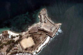
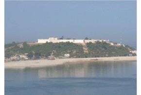
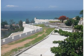
Fort Jesus Mombasa: a Portuguese fortress in Kenya


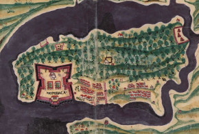
Written by Marco Ramerini. English text revision by Dietrich Köster.

In 1498 the Portuguese explorer Vasco da Gama arrived in Mombasa on his route to India. Fort Jesus was built after the Portuguese had become masters of the East African coast for nearly a hundred years. During this time they had as main base an unfortified factory at Malindi.

The Turkish raids of 1585 and 1588 were decisive for the Portuguese to decide on the construction of the fort in Mombasa. On 11 April 1593 the fortress was dedicated and named “Fortaleza de Jesus de Mombaça” by Mateus de Mendes de Vasconcelos (he was the captain of the coast, residing at Malindi). The fort was completed in 1596, the plan was a quadrilater with four bastions: S. Felipe, S. Alberto, S. Mathias and S. Mateus. The main gate was near S. Mathias bastion. Above the gate is a Portuguese inscription, which records the dedication to the fort: “Reinando em Portugal Phellipe de Austria o primeiro … por seu mandado ……. fortaleza de nome Jesus de Mombaça a omze dabril de 1593 ….. Visso Rei da Índia Mathias Dalboquerque ……. Matheus Mendes de Vasconcellos que pasou com armada e este porto ……. arquitecto mor da Índia João Bautista Cairato servindo de mestre das obras Gaspar Rodrigues.”

Fort Jesus, located on the edge of a coral ridge overlooking the entrance to the Old Port of Mombasa, was built by the Portuguese in 1593-1596 to protect their trade route to India and their interests in East Africa. It was designed by the Italian architect Giovanni Battista Cairati*. Mombasa became Portugal’s main trading centre along the East Coast of Africa.

The relation between the Portuguese and the Sultan of Mombasa began to deteriorate after the departure of the first captain Mateus de Mendes de Vasconcelos. In 1626 Muhammad Yusif, who had received education in Goa and who was baptized as Dom Jerónimo Chingulia, was made Sultan. On 16 August 1631 the Sultan Dom Jerónimo Chingulia entered the fort and took the Portuguese by surprise. He killed the Portuguese captain Pedro Leitão de Gamboa and massacred the whole Portuguese population of Mombasa (45 men, 35 women and 70 children). A Portuguese expedition was sent from Goa to retake the fort, but after two months of siege (10 January 1632-19 March 1632) they abandoned the enterprise. On 16 May the Sultan abandoned Mombasa and became a pirate. On 5 August 1632 a small Portuguese force under the captain Pedro Rodrigues Botelho, who had remained in Zanzibar, reoccupied the fort.

In February 1661 the Sultan of Oman sacked the Portuguese town of Mombasa, but did not attack the fort. It was in 1696 that a large Omani Arab expedition reached Mombasa. From 13 March 1696 the fort was under siege, the fort having a garrison of 50-70 Portuguese soldiers and several hundred loyal Coast Arabs. The fort was relieved in December 1696 by a Portuguese expedition, but in the following months a plague killed all the Portuguese of the garrison and by 16 June 1697 the defence of the fort was in the hands of Sheikh Daud of Faza with 17 members of his family: 8 African men and 50 African women.

On 15 September 1697 a Portuguese ship arrived with some reinforcement and also at the end of December 1697 another ship came from Goa with a few soldiers. After another year of siege the Portuguese garrison was reduced to the Captain, 9 men and a priest (Fr. Manoes de Jesus) in December 1698.

After a siege of two years and nine months the Omani Arabs took the fort. They could do this, because the garrison was reduced to nine soldiers, the others having died by disease. On the morning of 13 December 1698 the Omani Arabs did the decisive attack and took the fort. Just seven days later a Portuguese relief fleet arrived in Mombasa, but it was too late. With the conquest of Fort Jesus the whole coast of Kenya and Tanzania with Zanzibar and Pemba fell into the hands of the Omani Arabs.

The Portuguese retook the fort in 1728, because the African soldiers in the fort mutinied against the Omanis. The Sultan of Pate, to whom the fort was offered, handed the fort over to the Portuguese on 16 March 1728. In April 1729 the Mombasans revolted against the Portuguese and put under siege the garrison, who was forced to surrender on 26 November 1729.

The Fort is today known as one of the best examples of 16th century Portuguese military architecture. In 2011, Fort Jesus was declared a World Heritage Site by UNESCO.

*Giovanni Battista Cairati, born in Milan, was a leading military architect in the the service of King Philip II of Spain, who was also King of Portugal. He worked in Malacca, Mannar, Ormuz, Muscat, Damão, Bassein and Mombasa. He probably never saw Fort Jesus completed, because he died in Goa in 1596.

FORT JESUS TIMELINE

Mombasa: Fortaleza de Jesus (1593), Forte de São Joseph, Fortim da Ponta Restinga, Forte do Sorgidouro, Fortes da Macupa (three forts).

Portuguese: 11 Apr. 1593 Fortaleza de Jesus – 15 Aug. 1631
Sultan of Mombasa: 15/16 Aug. 1631 – 16 May 1632
Abandoned: 16 May 1632 – 5 Aug. 1632
Portuguese: 5 Aug 1632 – 13 Dec. 1698
Oman: 13 Dec. 1698 – Mar. 1728
Portuguese: 16 Mar. 1728 – 26 Nov. 1729
Oman: Nov. 1729 – 1741
Governor of Mombasa: 1741 – 1747
Oman: 1747
Governor of Mombasa: 1747 – 1828 (English protection 1824-1826)
Oman: 1828
Governor of Mombasa: 1828 – 1837
Oman: 1837 – 1856
Zanzibar: 1856 – 1895
English: 1895 – 1963

The Portuguese built several small forts around Fort Jesus in Mombasa for a better defence of the island. So many documentation exists on Fort Jesus, but about the others nearly nothing. There is also a confusion about the names.

The following list is the result of the research work done by Hans-Martin Sommer, M.A. Marine Archaeologist of the Fort Jesus Museum, Mombasa.

Information and photos by Hans-Martin Sommer (M.A. Marine Archaeologist of the Fort Jesus Museum, Mombasa). 

LIST OF PORTUGUESE FORTIFICATIONS IN MOMBASA:

FORT JESUS: the main Portuguese Fortress.

MAKUPA FORTS (Pos: 04 02′ 12,7″ S 39 39′ 09,7″ E): a small fort (15×15 m) and two towers at each side in a distance of about 100 metres.

“Os tres fortes da Macupa sao tres cazas, que estao feitas em quadro, ao longo do rio, na ilha de Mombaça, pera a banda da terra firme, em hum paço seco, os quaes se fizerao pera tolher a passajem aos Muzungulos da tierra firme pera a ilha. O de meyo he mayor, e nao tem mais que hua caza de sobrado com hua logea em baixo, a que se entra e sobe pella mesma logea (que tera sinco braças de vao tanto de largo como de comprido) cuberta por sima de terrado, onde asistem quinze soldados e hum bombardeiro portugues. Aos soldados se paga dezacete larins cada mes de mantimentos e ao capitao cento e sincoenta xerafins de ordinaria cada anno, o qual capitao o he tambem dos outros dois fortes que lhe fica cada hum de sua ilharga, distancia de hum tiro de espingarda pera cada parte, os quaes tamben sao cada hum hua caza de sobrado cuberta de terrado, mais pequena que o de meyo, que terao tres braças do vao. E asistem sinco soldados em cada hua, que pelejao com seus mosquetes por seteiras que estao feitas a rroda.” Antonio Bocarro “O Livro das Plantas de Todas as Fortalezas, Cidades e Povoaçoes do Estado da India Oriental”

Actual situation: This site was destroyed between 1900 and 1920. Rediscovered on July 2006, were found small wall remains in the ground. At the Eastside of the complex (distance to the fort about 120 m) were found the remains of a “wall, made from sundried bricks”. The east-tower was inside the complex. The other one is probably complete destroyed by the road and railway which leads in a distance of 120 m from the fort. The “Fortes de Macupa” were one fort with towers on each side. In Rezendes map of 1635 you can see the buildings of Makupa in nearly real shape.

Recostruction of Makupa Fort. A sketch by Hans-Martin Sommer after the first excavation and additional description of a german explorer in 1865. Exist an old photo from about 1900 which shows the ruins as very similar to the recostruction sketch.

ST. JOSEPH FORT (Pos: 04 04′ 18,1″ S 39 40′ 56.1″ E): a horseshoelike fortification in good condition. At about 100 metres distance to St. Joseph it was the Portuguese chapel “Nossa Senhora das Merces” (Pos: 04 04′ 21,2″ S 39 40′ 50,7″ E).

At about 100 metres distance to St. Joseph there used to be the Portuguese chapel “Nossa Senhora das Mercês” (Pos: 04 04′ 21,2″ S 39 40′ 50,7″ E).

GOLF COURSE FORT (Pos: 04 04′ 20,8″ S 39 39′ 07,5″ E): a few remains near the Golf Course.

HORSE SHOE FORT (Pos: 04 04′ 43,8″ S 39 40′ 20,2″ E): a very small fortification in good condition. Horseshoe Fort is a small bastion in good condition, no much infos available about its history

FORT OF THE ANCHORAGE (Pos: 04 04′ 33,06″ S 39 39′ 52,33″ E): also called ‘the round fort’ or ‘the hexagonal fort”, completly gone.

BIBLIOGRAPHY:

– Hinawi Mbarak Ali “Al Akida and Fort Jesus, Mombasa” 85 pp. East African Literature Bureau, 1950, Nairobi, Kenya.

– Boxer,Ch.R. – de Azevedo,C. “A fortaleza de Jesus e os Portugueses em Mombaça 1593-1729” 127 pp. 6 maps, Centro de Estudos Historicos Ultramarino, 1960 Lisboa, Portugal. History of Mombasa under the Portuguese, description of Fort of Jesus.

– Freeman-Grenville, G. S. P. “The Portuguese on the Swahili Coast: buildings and language” In STUDIA N° 49, pp. 235-253, 1989, Lisbon, Portugal.

– Kirkman,J. “Fort Jesus: a Portuguese fortress on the East African coast” 327 pp. 38 maps, Oxford University Press, 1974 London, United Kingdom. Detailed description of Fort Jesus by an archeological point of view.

– Nelson, W.A. “Fort Jesus of Mombasa” 84 pp. Canongate Press, 1994, Edinburgh, UK

– Pearson,M.N. “Port cities and intruders: the Swahili Coast, India and Portugal in the Early Modern Era” 202 pp. 2 maps, The Johns Hopkins University Press, 1998, Baltimore and London. Index: The Swahili coast and the Afrasian sea; the Swahili coast and the interior; East Africa in the world-economy; the Portuguese on the coast.

Written by Marco Ramerini. English text revision by Dietrich Köster.

Some old walls inside Fort Jesus, Mombasa. Author and Copyright Dietrich Köster
Cannons and buildings inside Fort Jesus, Mombasa. Author and Copyright Dietrich Köster..
This is the plaque presented by the Oman embassy in Kenya to the National Museum of Kenya with some historical dates of Fort Jesus. Author and Copyright Dietrich Köster.
This gun was salvaged from the German warship Konigsberg in World War I. Author and Copyright Dietrich Koster
Categories
Danish Colonialism Dutch Colonialism German Colonialism Ghana Portuguese Colonialism Swedish Colonialism

The European forts in Ghana

Written by Marco Ramerini. English text revision by Dietrich Köster.

FORT SÃO JORGE DA MINA (ELMINA)

The first European-built fort in Ghana was Fort São Jorge da Mina (Elmina), which was built by the Portuguese in 1482 near an African village, with which they traded, called by them Aldeia das Duas Partes. The foundation stone of this castle was laid on 21 January 1482 under the supervision of the Portuguese Captain Diogo de Azambuja, who was at the head of an expedition of 600 Portuguese.

This fort was the Headquarters of the Portuguese on the Gold Coast from its foundations to the Dutch conquest in 1637. The government of this castle was esteemed to be, at the beginning of XVIth century, one of the most important positions in the Portuguese empire. During the Portuguese time the garrison of the fortress consisted of a Governor with his staff of ten people, a factor or feitor with a staff of four men, two clerks, an apothecary, a surgeon, a smith, a cooper, an overseer of provisions, some stonemasons, some carpenters, two or four priests and about 20-60 soldiers.

In 1486 São Jorge was granted the City status, and a wall was built around the African settlement. From the first trading contacts the villagers of Aldeia das Duas Partes developed a kind of Portuguese Creole, which made the relationship between the Africans and the Portuguese easier. This language continued to be used till the XVIIIth century. In the first years of the XVIth century also the conversions of Black people began. In 1503 on the slopes of a hill near the castle was built a small chapel dedicated to Santiago. This chapel was used till 1596, when the building was dismantled.

Elmina Castle was very important for trade purposes. The trade goods of Mina were gold, ivory, sugar, wax, pepper, hides, slaves. Since the beginning of the Portuguese installation at São Jorge they established business relations with the adjoining African states (Akan, Wassaw, Commany, Efutu) to increase the trade. The Portuguese power on the Gold Coast never went beyond the coast-line. They built in 1503 the fort of Santo António de Axim, maintaining intermittently a trading post at Shama and in 1576 a short-lived fortress at Accra.

In 1596 during the government of captain Cristóvão de Melo (1596-1607) a Dutch expedition – equipped by the Dutch commercial trading house of Moucheron – attacked the castle for the first time. The attempt ended in a failure. On 7 September 1606 the Dutch made a second attempt to capture São Jorge; about 600 Dutch soldiers disembarked at Moure and later they marched against São Jorge. The Portuguese governor Dom Cristovão de Melo made a successful ambush with his troops and after two hours of fighting the Dutch were in retreat; in the meanwhile a small Dutch detachment had been sent towards Axim. Here after a fighting the Dutch beat the retreat, too. The Dutch made repeated assaults on São Jorge in December 1606 and January 1607, but finally in January 1607 they gave up. In 1615 a violent earthquake damaged the fortress walls and a bastion collapsed.

[divider]

Map of the Dutch, Portuguese, Danish, Swedish and Brandenburg forts in Ghana

[divider]

The Dutch – after having got knowledge of this – made three unsuccessful attacks against Elmina. In 1625 under the command of the Dutch Admiral Jan Dirickszon Lam a big Dutch squadron of 15 ships, 1.200 Dutch soldiers and 150 African allies anchored near Elmina with the aim to subdue the Portuguese fort. The fort was garrisoned by only 56 men under the Portuguese governor Dom Francisco Sotomaior and were assisted by a number of African allies.

On 25 October 1625 the Dutch opened the battle bombarding the castle. Later the Dutch began to march to São Jorge. The African warriors – allies of the Portuguese – ambushed the Dutch. They were taken by surprise. Confused by the unexpected assault, they beat the retreat leaving on the battle-field about 500 men. Thanks to their African allies this was a great victory for Portugal. In August 1637 a new Dutch squadron of 9 ships and 800 men anchored near Cabo Corso (Cape Coast), where they were joined by some 1.200 African allies. On 26 August 1637 the Dutch landed and – divided in three columns – marched towards the fortress. The first Dutch move in the attack of 1637 was the seizure of the unfortified hill of Santiago, from where they shelled São Jorge castle. By this strategic move the Portuguese were forced to surrender after a few days. The Dutch conquered Elmina on 29 August 1637. A Dutch garrison of 175 men was left in the castle. After more than 150 years a new European power – the Netherlands – ruled on the Gold Coast.

[divider]

Map of the Dutch, Portuguese, Danish, Swedish and Brandenburg forts in Ghana

[divider]

After the conquest the Dutch fortified the hill of Santiago with an earth-work. Later the fort on the hill – called Fort Conradsburg – was improved and enlarged and was completed by 1666. In 1645 the Dutch personnel at Elmina and Conradsburg consisted of 83 men and there were also 184 slaves working in the castle. The fort was in Dutch hands till 1872, when it was sold to the British. Very little of the early Portuguese castle is now visible. The only portion, which has remained intact, is the cistern that dates from 1482. The lay-out of today’s castle is the same, more or less, of the Dutch conquest in 1637. Outside the fort is still well preserved the Dutch Reformed church built at the end of the Dutch rule.

FORT SÃO SEBASTIÃO (SHAMA)

In the early years of Portuguese trading activity on the Gold Coast the first center, which was frequented by them, was the village of Shama, east of Cape Three Points. Here they maintained a small lodge for several years. In 1558 a wooden palisade and a tower were built and a permanent garrison was established. During the early 1600s the garrison of this station was formed by only one official and in 1637 the Dutch, when they occupied it, found this fort abandoned. They garrisoned it with a commander, 4 soldiers and 15 slaves (1645). In 1664 the fort was captured by the English, but a year later the Dutch regained possession of it and rebuilt it. Near the fort they maintained a cotton plantation from 1765 till 1783. This fort was in their hands till 1872, when it was ceded to the British.

FORT SANTO ANTÓNIO DE AXIM (AXIM)

In August 1503 a small trading-post was built by the Portuguese to the west of Cape Three Points. It was called Fort Santo António de Axim and in 1515 this fort was reinforced. The fort was an important trade center during the Portuguese rule. It was garrisoned by 10-20 Portuguese soldiers only, and they were – if necessary – assisted by a force of 150 African allies. After the Dutch capture of São Jorge Axim it remained in Portuguese hands for a few more years. A first Dutch attack was driven back in 1641, but in February 1642 a new attempt was successful and the Dutch occupied the fort. In 1664 the English captured the fort, but the Dutch soon retook it. It was in Dutch hands till 1872, when it was sold to the British.

ACCRA

In 1557 the Portuguese built a small fortified lodge in Accra. In 1576 they decided to enlarge the lodge and to build a strong fort, but in 1577/78 Africans attacked the half-built fort and destroyed it.

FORT NASSAU (MOREE)

Between 1595 and 1600 merchants from the Netherlands founded a small unfortified lodge at Moree for trade in gold. In 1610 the Portuguese made an attack against the Dutch trading station at Moree. They burnt the African village adjoining the lodge. In reaction to this attack the Dutch built their first fort on the Gold Coast in 1612: Fort Nassau. This fort was originally a small earthwork and wooden fort and was built on a hill overlooking the sea at Moree. It was rebuilt and enlarged in 1623-24 and in 1633-34. In 1615 a new Portuguese raid was successful and the African town was newly burnt. Moree was the Dutch headquarters till the conquest of Elmina in 1637. In 1645 the Dutch garrison was composed of 32 men including the commander. There were then a surgeon, a preacher, a coppersmith and 156 slaves working in the castle. Moree was occupied by the British in 1664 and recaptured by the Dutch in 1665. In 1782 it was again in British hands, but the Dutch regained it by treaty in 1785. In the first decades of the 19th century it was abandoned. The remains of this fort are nowadays only very few.

FORT CHRISTIANSBORG (ACCRA)

In 1652 the Swedes built a lodge in Accra and in 1660 it was seized by the Dutch. In 1661 the Danes occupied the place and built a fort named Fort Christiansborg. This fort was situated near two other forts: Fort Crèvecœur and Fort James, the former Dutch and the latter English. The Danish fort was located on a rock cliff near the African town of Osu and its position was the best of the three. The fort was in Danish hands for nearly two hundred years except for a short Portuguese occupation. On 2 December 1680 a Portuguese ship arrived at the Danish fort. The Danish Governor Bolt sold the fort to the Portuguese commander of the ship Julião de Campos Barreto. The Portuguese renamed it Fort São Francisco Xavier and built a chapel in the fort. The Portuguese abandoned the fort on 29 August 1682. It was then occupied by the Akwamu tribe until February 1683, when the Danes from nearby Fort Fredriksborg reoccupied it. In 1685 the Danes moved their headquarters from Fort Fredriksborg to Fort Christiansborg. The fort was square shaped with four bastions. In 1693 an African tribe occupied the fort, but in 1694 the Danes retook it. The Danes made several attempts to establish plantations near the fort and they also established in the early 1800s a hill-station and a plantation thirty–two kilometers inland from Fort Christiansborg at Kpomkpo (Frederiksborg). In 1850 the Danes sold the Castle to the British.

[divider]

[divider]

FORT GROSS-FRIEDRICHSBURG (PRINCESTOWN)

Brandenburg was a historic Electorate (Kurfürstentum) which formed the primary nucleus of the Prussian State. Under the reign of the Grand Elector Friedrich-Wilhelm von Brandenburg, was created an African Company, this company for about forty years ruled on several African forts at: Arguin, Takrama, Takoradi, Akwida (Ft. Dorothea), Whydah and Princestown or Poquefoe (Gross-Friedrichsburg). On New Year’s Day 1683 a Brandenburg expedition of two ships arrived on the Gold Coast and started to build a strong fort between Axim and Cape of Three Points, which was named Gross-Friedrichsburg. The fort was to be the headquarters of Brandenburg in Africa, it was garrisoned at the beginning by 91 European men and 130 Africans. The fort was a square shaped with four bastions. In the first 15 years the Brandenburgers developed well the trade with the Africans, but from 1700 trade began to decline. The Company was an ally of the African chief John Couny who was waging a war against the Dutch and the English. In 1720 a treaty was concluded between the King of Prussia and the Dutch, and all the African forts of Brandenburg were sold to the Hollanders, but the African ally of Prussia/Brandenburg, John Couny, refused to surrender Gross-Friedrichsburg. In 1725 the Dutch captured Fort Gross-Friedrichsburg and renamed it Fort Hollandia. The fort was abandoned by the Dutch in 1815.

FORT AMSTERDAM (CORMANTINE)

In 1631 the English had a lodge in Cormantine. In 1645 they built a fort on the summit of a hill. In 1665 the Dutch occupied it during a struggle and renamed it Fort Amsterdam. In 1782 the Dutch surrendered the fort to the British, but in 1785 it was newly in Dutch hands by a treaty. In 1811 the African tribe of Anomabu captured the fort, which was later abandoned.

[divider]

[divider]

BIBLIOGRAPHY ON THE EUROPEANS FORTS IN GHANA

– Bato’ora Ballong -Wen-Mewuda, J. “São Jorge da Mina 1482-1637” 2 voll. 642 pp. Fondation Calouste Gulbenkian-C.N.p.l.C.d.D.P. 1993 Lisboa-Paris Complete study on Elmina castle during the Portuguese period.

– Cardinall, Allan Wolsey “A Bibliography of the Gold Coast” Martino Publishing & Wayfarer’s Bookshop, Mansfield Centre, 2002, CT

– Decorse, Christopher “An Archaeology of Elmina : Africans and Europeans on the Gold Coast, 1400-1900” Smithsonian Institution Press, 2001

– Ephson, I. S. “Ancient forts and castles of the Gold Coast (Ghana)” 112 pp. 18 ills. Ilen Publications 1970 Accra, Ghana Index: The origins; location of the forts and castles; number of forts and castles; the tenants; unhappy incident; gallant governors; problems of the forts and castles; no more forts and castles; cui bono; the surviving settlements.

– Feinberg, Harvey M “Africans & Europeans in West Africa: Elminans & Dutchmen on the Gold Coast during the Eighteenth Century” 189 pp. Diane Publishing Co., 1989 The town of Elmina was the most important trading center on the Gold Coast (GC) of W. Africa for at least 2 cent. Elminans engaged in commercial transactions which linked the GC with 3 very different trade networks. Contents: (I) The Akan on the GC; (II) Europeans on the GC: The Portuguese, 1471-1642; & The Dutch from 1593; (III) Akan Participation in the Atlantic Trading System; (IV) An Intro. to Elmina; (V) The Elmina Political Framework; (VI) The Functioning of Govt.: Justice & Dispute Settlement; & Foreign Affairs; & (VII) Elmina-Dutch Relations. Appendices: Elmina Chronology; Weights, Measures & Def.; Dirs. Gen. & Pres. of the 2nd W. India Co.; Counts of Indictment & Defense of the Negroes of Mina; & Elmina Leaders. Biblio. Illustrations.

– Giordano, Rosario “Religione e politica nel confronto tra missionari cattolici e brasiliani a Ouidah, 1861-1871” In: “Africa” LIII, 2, 1998, pp. 239-257

Iria, Alberto “Da fundação e governo do Castelo ou Fortaleza de São Jorge da Mina pelos Portugueses e da sua acção missionaria após o descobrimento desta costa” In STUDIA N° 1, pp. 26-69, 1958, Lisboa, Portugal.

– Kessel, Ineke van “Merchants, Missionaries and Migrants: 300 Years of Dutch-Ghanaian Relations” Kit Publishers, In November 1701, David van Nyendael, an envoy of the Dutch West India Company (WIe was the first European to visit the royal court in Kumasi, capital of the emerging Ashanti empire in the hinterland of the Gold Coast. Three hundred years of Dutch-Ghanaian relations have passed since then. “Merchants, Missionaries and Migrants” focuses on various aspects of this long-standing and intricate economic, political and cultural relationship between the Ghanaians and the Dutch. Experts from Ghana, the Netherlands, Suriname and Indonesia present their research findings in fascinating histories. They describe a wide range of topics from Dutch-Ghanaian history: from the trade in gold, ivory and slaves to the cocoa trade; from liaisons between European men and African women in previous centuries to present-day Ghanaian migration to the Netherlands; from the involuntary migration of tens of thousands of slaves to the plantations in Suriname to the largely forgotten history of the African soldiers who sailed from Elmina to serve in the Dutch army in the East Indies; and from the role of Dutch geneva in Ghanaian ritual to the tragic story of Jacobus Capitein, the first black Christian minister to be ordained in the Netherlands.

– Lawrence, A. W. “Trade Castles and Forts of West Africa” 390 pp. 48 maps & 158 plates Jonathan Cape 1963 London, U.K. A detailed description of about 40 Europeans forts and castles from Arguin (Mauritania) to Whydah or Ouidah (Benin). Many illustrations and maps of the forts. Chronological history of the forts. Index: The place of the fortsystem in history; the setting of times; organization and personnel; life at the forts; relations between fort and town; types of building; materials and structure; early draughtsmen; Elmina castle: the Portuguese and later Dutch headquarters; other headquarters: Cape Coast Castle, Christiansborg, Princestown; early forts: Axim, Mouri, Cormantin, Gambia, Butre, Shama; forts about 1700: Akwida, Commenda, Dixcove, Apam, Sekondi, Beraku; forts of the late eighteenth century: Anomabu, Beyin, Keta.

– Pezzoli, G. & Brena, D. “Forti e castelli di tratta” 50 pp. Centro Studi Archeologia Africana, 1990, Milano. A collection of several plates of European castles in Africa.

– Van Dantzig, A. “Forts and castles of Ghana” Sedco, 1980, Accra, Ghana. – Van Dantzig, A. and Priddy, B. “A short history of the forts and castles of Ghana” 59 pp. map and ills. Liberty Press, 1971, Accra, Ghana. Index: The Portuguese period, Dutch penetration and the expulsion of the Portuguese, English Swedish and Danish penetration, growth of the English trade, the Brandenburg Company, the 18th. century, the 19th century.

– Vasconcelos, Frazão de “A Fortaleza de São Jorge da Mina” 14 pp., [2] pp. Mundo Português, 1934, Lisboa, Portugal.

– Vogt, J. “Portuguese rule on the Gold Coast 1469 – 1682” 266 pp. 2 maps University of Georgia Press 1979 Athens, Georgia, USA Complete study on the Gold Coast during the Portuguese period.