Categories
Portuguese Colonialism United Arab Emirates

Portuguese Fort at Bidyah in the United Arab Emirates

Written by Marco Ramerini, Photos and Information by Michele Ziolkowski

The town of Bidyah in the United Arab Emirates, is found midway along the coast between Fujairah and Dibba. According to the Portuguese souces, the Portuguese had in the area a fort called Libidia. A team consisting of Australian and local archaeologists excavated the area in 1999.

The site of the fort at al-Bidyah (25°26′ N, 56°21′ E) consists in a large square enclosure constructed with large boulders at the foundation level and smaller mountain and wadi rocks used for the successive courses. The forts walls are each around 60 metres in lenght. Excavation was concentred on the north western tower and both the northern and western fort walls. During the excavation were located the remnants of the north western and north eastern towers. (1)

(1) Ziolkowski, Michele “Excavations at Al-Bidiyya: new light on the Portuguese presence in the Emirates” p. 20

From: “O Lyvro de Plantaforma das Fortalezas da Índia, na Fortaleza de S. Julião da Barra, com 22 plantas de anónimo (I – Manuel Godinho de Erédia, de cerca de 1620), e 55 plantas de anónimo (II – de cerca de 1640)”: Hnã legoa de Corfacan … a Norte da praia esta situada a fortaleza de Libidia ……… sua pouoacão de ate 200 vezinhos fundou Matheõs de Ciabra no anno de 1623 por m.do (mandado) do Capp.ão (Capitão) g.al (geral) Ruy Freire: tem de prezidio um Capp.ão (Capitão) Lascarim e 20 soldados.

[divider]

[divider]

BIBLIOGRAPHY:

– Ziolkowski, Michele “Al-Bidyah excavations, 1999” In: “BSAI Nesletter” n°4, November 1999, British School of Archeology in Iraq.

– Ziolkowski, Michele “Excavations at Al-Bidiyya: new light on the Portuguese presence in the Emirates” In: “Tribulus” Vol 9.2, pp. 19-21 Autumn/Winter 1999, Bulletin of the Emirates Natural History Group.

– Ziolkowski, Michele “The Historical Archeology of the Coast of Fujairah, United Arab Emirates: from the Eve of Islam to the Early Twentieth Century. Volume I: text” Unpublished Thesis, University of Sydney, Australia. pp. 284-451

Categories
Dutch Colonialism Portuguese Colonialism Sri Lanka

Dutch and Portuguese remains in Sri Lanka: forts and churches

Written by Marco Ramerini. English text revision by Dietrich Köster.

DUTCH AND PORTUGUESE REMAINS IN NORTHERN SRI LANKA

JAFFNA

The Portuguese built the fortress Nossa Senhora dos Milagres in 1560. Jaffna was the last place in Portuguese hands in Ceylon. They lost it in 1658. The Dutch strengthened the fort around 1680. The old Dutch fort of considerable size with its ramparts, bastions and gateways was still in a good state of preservation before the civil war. It was the Governor’s residence. The Dutch church (Kruyskerk or Groote Kerk) dates from 1706. Inside there were beautiful tombstones.

On the Jaffna peninsula there are (or better there were *) the remains of several Portuguese Jesuit churches in Chankanai (1641), Atchuveli, Myliddi, Vaddukoddai. A Dutch church is (was?) at Chundikuli.

* I don’t know the actual situation of the Dutch and Portuguese remains in Northern Sri Lanka. If somebody has photos or information on the actual situation. I shall be happy to receive them for publication.

MANNAR

Mannar Fort, Sri Lanka

The fort was built by the Portuguese in 1560 and they surrendered it to the Dutch on 22 February 1658. The fort was rebuilt by them in 1686. On 5 October 1795 the Dutch surrendered it to the British. The fort has four bastions and it is still in good condition.

In the village of Karisal (13 Km west of Mannar) there are the remains of the walls of a Portuguese church.

TRINCOMALEE

The Portuguese were the first to build a fort here, they in 1623 destroyed an ancient Hindu temple and at its place built a fort. This fort was taken by the Dutch on 2 May 1639. The Dutch strengthened this fort in 1658 and called it Fort Pagoda (today fort Frederick). This fort is still in good preservation.

At the beginning of XVIII century Fort Oostenburg was built on a hill East of the entrance to the inner bay. Later a battery was erected on the island “Dwars in de Weg”, too. A few ruins of this fort still remain.

In the village of Nilaveli (north of Trincomalee) an old Dutch two-storied building is to be found, of which the roof has crumbled.

BATTICALOA 

This fort was built by the Portuguese in 1628 and was the first to be captured by the Dutch (18 May 1638). It is the most picturesque one among the small Dutch forts of Sri Lanka. It is situated on an island and is still in good condition.

Near Batticaloa the Portuguese had a tiny fort at Tanavare (a map of it exists). No remains.

Map of Northern Sri Lanka with Dutch and Portuguese remains. Author and Copyright Marco Ramerini

KALPITIYA or CALPENTYN

A five-bastion Dutch fort was built in 1667. It is still in good state of preservation. Inside the fort there are the remains of an old Portuguese Jesuit church.

ARIPPU 

A small fort built by the Portuguese in proximity of the pearl-banks. It was taken by the Dutch after the fall of Mannar. No remains ?

MULLAITTIVU

This fort was built by the Dutch in 1715 and was originally a small wooden structure. In 1721 a quadrangular fort of earth-work was erected. The English rebuilt it. No remains ?

KODDIYAR or COTIAAR

Here the Dutch had a small out-post in the first years; this out-post was fortified in 1658. No remains ?

DELFT

The Portuguese called this island Ilha das Vacas. They had a fort here. There are two ruined forts in this island: That on the eastern sea shore is the Portuguese small fort or “tranqueria” with only two ruined walls still existing. The other fort was probably built in more ancient times. I don’t know the actual situation of this fort.

KAYTS

A Portuguese fort with four circular bastions. It was taken by the Dutch. They made no attempt to restore it. Remains (at Velani)?.

HAMMENHEIL

This fort stands on a tiny island at the entrance to the Jaffna lagoon. Here the Portuguese built a fort called Fortaleza do Cais dos Elefantes. In March 1658 it was taken by the Dutch. The fort has only one entrance and was garrisoned by 30 men. It is still in good condition (?).

KANKESANTURAI or CANGIANTURE

Here the Dutch originally intended to establish the capital of the Jaffna commandment. Here they began to build a fort, but later they changed their mind. No remains.

PUNT DE PEDRO

Small fort built originally by the Portuguese, rebuilt by the Dutch. No remains.

POONERYN

This fort is situated South of the Jaffna lagoon. A quadrangular fort with two bastions, probably built originally by the Portuguese. It is fairly well-preserved (?).

ILPECARWE

A Dutch fort north of Mannar. No remains.

FORT PYL

Fort Pyl plan: A strategic Dutch fort. Only a raised rampart is left over (?).

FORT BESCHUTTER

A strategic fort built by the Dutch near the village of Koyilvayal. This little fort is in very bad condition.

FORT ELEPHANT PAS

A strategic Dutch fort: It is the best preserved of the three small forts on the northern shore of the lagoon on the Jaffna peninsula. I don’t know the actual situation of this fort.

DUTCH AND PORTUGUESE REMAINS IN SOUTHERN SRI LANKA

COLOMBO

Colombo was the capital of Portuguese Ceylon and here the Portuguese built several churches ( São Francisco, São Paulo, São Domingo, São Lourenço, Capuchinhos, Sé Catedral/Igreja Matriz etc.), many houses, a hospital, a Santa Casa da Mesericórdia, many convents, a customs-house (Alfândega) etc.. The old Portuguese town was encircled by walls and bastions. The first fort (called Santa Barbara) was built in 1518 but in 1524 it was abandoned. In 1554 a new fort was built and the city of Colombo developed. The Portuguese town was destroyed by the Dutch during the siege in 1655-56. Of the Portuguese churches only that of São Francisco survived and was used by the Dutch as a Dutch Reformed Church until 1749, when it was demolished. The Dutch rebuilt Colombo and strengthened its bastions. In 1870 the Dutch fort of Colombo was demolished by the British. The old Portuguese and the Dutch fort disappeared. Only the wall of a bastion remains.

The best example of a Dutch house in Colombo is the building of the Dutch period museum that was built in the latter part of the 17th century. Outside the fort there was and there is the Wolfendahl church; it’s a massive cruciform building, built by the Dutch in 1749, on the site of the Portuguese church of “Água de Lupo”. It is the most interesting of the few remains in Colombo of the Dutch period. Several tombstones of the Dutch Governors (Hertenberg, Vreelandt, van Eck, Falck, van Angelbeek) and Burghers are here. In the vicinity of the church there is the old Dutch belfry. The residence of the Dutch Governors was in front of the Colombo harbour. This building was converted into a church (St. Peter’s Church) by the British in 1804.

GALLE

Dutch Fort, Galle, Sri Lanka. Author and Copyright Dietrich Köster

It was not till the Portuguese occupation that Galle rose to importance. They fortified it at the end of the XVIth century (around 1589) and called this fortress Santa Cruz, but notwithstanding this Galle was conquered by the Dutch on 13 March 1640. It was the principal port of the island under the Dutch. They greatly strengthened the fortifications. Galle was the capital of Dutch Ceylon from its conquest (1640) till the conquest of Colombo in 1656. The old Dutch Government House dates from 1687. It is the best preserved of the VOC fortress in Ceylon with beautiful ramparts, bastions and gateways. Galle is a fortified Dutch city. There are many old Dutch houses and a beautiful Dutch church dating from 1752-54 is still in use. Its walls are full of numerous tablets and family coats of arms. In this church are also interesting old tombstones to be found.

MATARA

The fort was built by the Portuguese about 1550, but the actual fort was built by the Dutch, when they took Matara after the capture of Galle. The remains of the fort (a rampart and a gateway) are in a good state of preservation . Inside the fort there are several old Dutch houses and a church with gravestone on the floor dated from 1686. After the Matara rebellion in 1761-1762 a beautiful fort called redoubt “van Eck” was built on the right bank of the river in 1763-1765. This fort is the unique star shaped fort in Ceylon, over the gate of the fort is the Dutch coat of arms. It’s still in good preservation.

NEGOMBO

The fort was built by the Portuguese at the end of the XVIth century. It was not a strong fort, but was important for the defense of Colombo. The Dutch took the fort by storm on 10 February 1640, but on 9 December 1640 the Portuguese succeeded in retaking it. Negombo was finally in Dutch hands in January 1644. In February 1796 the British occupied it. There are some remains of the walls and an arched gateway of the fort. Opposite the fort is an ancient Dutch cemetery with 9 monuments of the Dutch period.

Map of Southern Sri Lanka with Dutch and Portuguese remains. Author and Copyright Marco Ramerini

KALUTARA or CALITURÈ

The fort was built by the Portuguese and was conquered by the Dutch on 15 October 1655. In 1677 the Dutch remodeled the fort and in February 1796 the fort was occupied by the British. There are a few remains of the walls of the fort.

MENIKKADAWARA

Here the Portuguese had a fortified base camp in the 1590s. Earthwork remains.

ARANDORA

Here the Portuguese had a fortified base camp. No remains.

BALANE

Here the Portuguese had for a few years a strategic fort and an outpost on the way to Kandy for a few years. No remains.

SABARAGAMWA – RATNAPURA

Here the Portuguese had a fortified outpost. There is a little Portuguese church with a Portuguese stone slab on a wall.

KATUWANA or CATTOENE

This fort was built before 1697. In 1761 it was destroyed by the Kandyans. It is now a beautiful restored fort.

MALWANE

Here the Portuguese had a fortified base campm in the 1590s. No remains.

ANGURUWANTOTA or ANGURATOTA

In the years of the war with the Portuguese the Dutch erected a strong stockade fort here. No remains.

HANWELLA or GURUBEWILA

Hanwella Fort plan A stockade was built here by the Portuguese at the end of the XVIth century. The Dutch built a strong fort at the end of the XVIIth century. It disappeared, but traces of the old moat of the fort are still to be seen.

SITAWAKA or AVISSAVELLA

This fort was built by the Portuguese in 1595. It was a small fort on the top of a low hill; in 1675 the Dutch built a strong fort with four bastions on another hill north of the old Portuguese fort. In 1685 this fort was abandoned. Disappeared, only a few traces are visible.

RUWANWELLA

Here the Portuguese had a fortified base camp in the 1590s. In 1665 the Dutch built a wooden fort. It was abandoned by the Dutch a few years after its construction. The actual fort was built with two bastions by the British in 1817.

PANAMA, YALA, MAGAMA

The Dutch also had military posts in these places for a short time. No remains.

THE DUTCH WATERWAYS

The Dutch waterways are by now fallen into disuse, but there is a project to restore them. In the Dutch time they were very useful for the trade and connected Colombo to Negombo; Colombo to Kalutara; and Negombo to Chilaw, Puttalam and Kalpitiya. The Dutch also built canals in Galle, Matara and Batticaloa.

Categories
Portuguese Colonialism Sri Lanka

The Portuguese in Ceylon: The Portuguese in Sri Lanka before the war with the Dutch

Written by Marco Ramerini. English text revision by Dietrich Köster.

The first Portuguese visiting Ceylon was Dom Lourenço de Almeida in 1505 or 1506. Accidentally, after a storm, adverse winds drove him to the island’s coast near Galle. In the last months of the years 1505 or 1506 Dom Lourenço’s fleet anchored off Colombo.

A memorial of this first landing was erected on a boulder overlooking the Bay of Colombo. The Portuguese call it a “Padrão”. It is a stone cross displaying the Royal Arms of Portugal. This landmark was still seen in 1920 (Still today?) bearing the inexplicable date of 1501. This first expedition admittedly built a wooden chapel and a factory agency in Colombo. These structures were abandoned a few years later. A treaty was concluded with the King of Ceylon, than residing in the city of Kotte, about two hours by foot from Colombo.

At the time the Island was divided into four Kingdoms: Kotte, the most important, Sitawaka, Kandy in the mountains, and Jaffna in the North.

In 1518 the Viceroy Lopo Soares de Albergaria landed in Colombo with a large fleet. Here the Portuguese began to build a small fort named “Nossa Senhora das Virtudes” or “Santa Bárbara”. This first fort was triangular in shape, surmounted by a central tower. Singhalese soon besieged the fort and around 1524 the Portuguese dismantled it.

The Portuguese kept an agent on the Island under the protection of the Singhalese King at Kotte. Giving up of Colombo was a mistake. The colony of Muslim merchants immediately attempted to win back their supremacy in the Kingdon of Kotte and to regain the cinnamon trade. However, they were to be defeated by the few Portuguese still present on the Island.

The Mappillas (Malabar Muslims), who up to 1539 waged a dynastic conflict in the Kingdoms of Sitavaka and Kotte, opposed the Portuguese presence in Ceylon. Martin Afonso de Sousa would definitely defeat the Mappillas at Vedelai in 1538 and Miguel Ferreira at Negombo in 1539. Also in these years with the encouragement of the King of Kotte, the missionaries began the work of converting the peoples of Ceylon to Christianity. Churches were erected in the fishing village of the southwestern coast. Tragically the King of Jaffna massacred more than 600 Christians on the island of Mannar in 1544. However in 1545 the King of Jaffna submitted and paid tribute to the Portuguese.

In October 1550 the Viceroy Afonso de Noronha arrived in Ceylon with 500 Portuguese soldiers, who occupied Kotte and sacked Sitawaka. But the Viceroy lost a good opportunity of establishing the supremacy of Portugal over the entire island. In November 1554 Duarte de Eça built with 500 soldiers a new fortress in Colombo. By 1556 the communities of fishermen occupying the sea coast south of Colombo (70.000 people) were converted to Christianity. The King of Kotte, Dharmapala (rechristened as Dom João Perya Bandara) and the Queen (rechristened as Dona Catherina) were converted to Christianity. Following the King’s example, a few nobles adopted the Portuguese title of Dom (Sir), the Portuguese manners and language. These conversions were a serious mistake for the King and his entourage, because they alienated the majority of the Singhalese population.

In 1560 Viceroy Dom Constantino de Bragança with 1.200 men conquered the town of Nallur, the capital city of the Kingdom of Jaffna, and soon afterwards the Viceroy proceeded to the island of Mannar where a fort was built. In July 1565 the Portuguese decided to transfer the Court and the capital to Colombo. Thus Kotte was abandoned.

The Portuguese at Colombo were surrounded, because the Singhalese had three strong garrisons around Colombo at Wattala, Nagalagama and Mapane. Only in 1574 the Portuguese took the offensive. They plundered Negombo, Kalutara and Beruwela, drove out the garrisons in Nagalagama and Mapane and ravaged the districts of Weligama and Chilaw. In August 1587 Raja Sinha, the King of Kandy and Sitawaka, began the siege of Colombo. The Portuguese town was protected by fortifications with 12 bastions, which the Singhalese assaulted many times, but always failed. In February 1588 they abandoned the siege.

Till the very end of the XVIIth century the Portuguese were masters of the coast forts of Colombo, Galle, Kalutara and Negombo. In 1591 Andre Furtado de Mendonça invaded Jaffna and nominated a new king at Nallur. The Portuguese occupied Kandy for a brief period in 1592, but after a few weeks they were forced to withdraw. They were also masters of the Kingdoms of Kotte and Sitawaka, but several attempts to occupy Kandy resulted in a failure. In 1597 the Portuguese had begun to fortify Galle.

On 27 May 1597 King Dom João Dharmapala died in Colombo without heirs and in accordance with his will, his Kingdom was donated to the King of Portugal. Thus, as King Philip of the then United Kingdoms of Spain and Portugal was proclaimed King of Ceylon, the whole of the territory of the Kingdom of Kotte was thus under the control of the Portuguese, only Kandy was not yet under Portuguese rule. In 1598 the Portuguese occupied Etgala Tota, which commanded the passage of the river Maha Oya. In 1599 a strong fort was erected at Menikkadawara (Manicavare) at the Kandian’s border.

Portuguese forts in Ceylon. Author and Copyright Marco Ramerini

On 31 May 1602 the first Dutch expedition arrived in Ceylon. They dropped anchor at Batticaloa, a harbor, which the Portuguese had never occupied, and established friendly relations with the King of Kandy against the Portuguese. In January 1603 Dom Jerónimo de Azevedo occupied the fort of Ganetenna and the abandoned fort of Balane, the key to Kandy. However, a few days later he was forced to withdraw and Menikkadawara was also lost.

On 1611, de Azevedo marched with 700 Portuguese and many Lascarins to Kandy, taking also possession of the fort of Balane, where he left a garrison. He was also successful in conquering the city of Kandy, which was taken and burnt. The King of Kandy submitted himself to the Portuguese. Although not destroyed, the Kingdom of Kandy had been neutralized.

In 1624 the Portuguese occupied and fortified Trincomalee. In 1628 Dom Constantino de Sá, after strengthening Menikkadawara, crossed the island and occupied and fortified Batticaloa. During the return march to Colombo he raided Kandy. In 1629 Uva (today Badulla) was also devastated.

In 1630 Dom Constantino de Sá, under pressure from the Viceroy, decided to undertake an expedition against the King Senarat’s capital at Badulla. On 9 August 1630 a small Portuguese army of 400 Portuguese soldiers, 200 Portuguese Casados (married men of the reserve army), and about 4400 Lascarins began the march from Sabaragamwa (near Ratnapura) to Uva across Ceylon’s jungles. On 18 August 1630 the Portuguese entered Badulla, which was found deserted, and sacked and burned the town down for two days. On 21 August 1630 the Portuguese began the march to return to Colombo, but were attacked by the Singhalese army. Most of the Lascarins betrayed – only 500 remained loyal – and joined the enemy. For the Singhalese this was an overwhelming victory: of the Portuguese expedition only 130 men survived and surrendered. This defeat placed Portuguese Ceylon in danger. If the Singhalese had the means of blockading Colombo by sea, the complete destruction of Portuguese power in Ceylon would have been assured. After this victory King Senarat captured the fort of Saparagamuwa and set Colombo under siege. But after three months of siege the Singhalese army was forced to withdraw.

To be continued: The war against the Dutch

LEGEND

  • Red: Dutch territory
  • Yellow: transitory Dutch conquest 1765-1766.
  • Green: Portuguese territory

THE PORTUGUESE GOVERNORS OF CEYLON (Capitão Geral)

Pero Lopes de SOUSA 1594

Dom Jerònimo de AZEVEDO 1594 – 1611

Dom Francisco de MENESES 1611 – 1614

Manuel Homem MASCARENHAS 1614 – 1616

Dom Nuno Alvares PEREIRA 1616 – 1618

Dom Costantino de SA’ e MENENES de NORONHA (first term) 1618 – 1620

Jorge de ALBUQUERQUE 1620 – 1623

Dom Costantino de SA e MENESES de NORONHA (second term) 1623 – 1630

Dom Felipe MASCARENHAS (first term) 1630 – 1631

Dom Jorge de ALMEIDA (first term) 1631 – 1633

Diogo de MELO de CASTRO (first term) 1633 – 1635

Dom Jorge de ALMEIDA (second term) 1635 – 1636

Diogo de MELO de CASTRO (second term) 1636 – 1638

Dom Antonio MASCARENHAS 1638 – 1640

Dom Felipe MASCARENHAS (second term) 1640 – 1645

Manuel Mascarenas HOMEM 1645 – 1653

Francisco de MELO de CASTRO 1653 – 1655

Antonio de Sousa COUTINHO 1655 – 1656

BIBLIOGRAPHY:

– Various Authors “History of Ceylon” Vol. 1, parts 1 & 2: “Pre-Colonial Period” ? University of Ceylon, 1959/60, Colombo, Sri Lanka. Vol. 2: “History of Sri Lanka vol II (1500-1800)” 614 pp. Ed. by K.M. de Silva, University of Peradenya, Ceylon, 1995, Colombo, Sri Lanka.

– Abeyasinghe, T. “Portuguese rule in Ceylon 1594-1612” xi, 247 pp. ills, 3 maps, 2 plates Lake House Investments, 1966, Colombo, Sri Lanka.

– Abeyasinghe, T. “Jaffna under the Portuguese” 66 pp. ill. Lake House, 1966, 1986, Colombo, Sri Lanka.

– Baldaeus, Philip “A Description of the great and most famous Isle of Ceylon” 165 pp. maps, Reprint of the 1703 edition, Asian Educational Services, 1996, New Delhi-Madras, India.

– Bouchon, Geneviéve “A Propos de l’Inscription de Colombo (1501) Quelques Observations sur le Premier Voyage de João da Nova dans l’Ocean Indien” ? In: RUC, vol. XXVIII, pp. 233-270 Universidade de Coimbra, 1980, Coimbra, Portugal.

– Boxer, Ch. R. “Christians and spices: Portuguese missionary methods in Ceylon 1518-1658” ??? In: History Today Vol. VIII, 1958, pp. 346-354

– Brohier, Richard Leslie and Raheem, Ismeth “Changing face of Colombo, 1505-1972 covering the Portuguese, Dutch, and British periods R.L. Brohier. Views of Colombo, 1518-1900” xv+68 pp. 11 maps and ills. 22 plates Lake House Investments, 1984, Colombo, Sri Lanka.

– Buultjens, A. E. “Dom Jerónimo de Azevedo. Governor of Ceylon from 1594 to 1611 A.D.” In: Journal of Royal Asiatic Society (Ceylon) Vol. XV n° 49, 1898 pp.201-212

– Correa, Gaspar “Gaspar Correa’s account of the Portuguese in Ceylon in the first half of the 16th century” In: “Ceylon Literary Register” pp. 179-181

– Coutinho, Xavier “Portugal na história e na arte de Ceilão ” 101 pp. illustrations, separata de STUDIA N° 34-35, 1972, Lisbon, Portugal.

– Faria y Souza “An account of events in Jaffnapatnam (1619-1621)” From: “Ásia Portuguesa” Volume VI, pp. 187-190, pp. 212-217 translated by Dennis Crowder.

– Ferguson, D. W. “The condition of Ceylon under the Governorship of Dom Jerónimo de Azevedo” ??? In: Monthly Register and Notes and Queries for Ceylon IV, 1896, pp. 209-214

– Ferguson, D. W. “The discovery of Ceylon by the Portuguese in 1506” ? In: Journal of the Ceylon Branch of the Royal Asiatic Society, Vol. XIX, 1907, pp. 321-385 and pp. 84-114

– Fernando, C. N. “Christianity in Ceylon in the Portuguese and Dutch period” ??? In: University of Ceylon Review, Vol. VI, 1948, pp. 267-288

– Fitzler, M. A. Hedwig “O cerco de Columbo 1652-1656: últimos dias do domínio Português em Ceilão” ??? xxv + 236 pp. Memórias do Instituto de Coimbra N° 1, Impr. da Universidade, 1928, Coimbra, Portugal.

– Fitzler, M. A. H. “Ceilão e Portugal” ??? xxv, 236 pp. Imprensa da Universidade, 1928, Coimbra, Portugal. English ed. “Ceylon and Portugal: Kings and Christians 1539-1552” ??? Leipzig, 1928

– Flores, J. M. “Os Portugueses e o Mar do Ceilão . Trato, diplomacia e guerra (1498 – 1543)” 368 pp. 2 maps Edições Cosmos 1998 Lisboa, Portugal.

– Goonatilleka, M. H. “Ceilão e Portugal. Relações culturais” In STUDIA N° 30-31, pp. 113 – 161, 1970, Lisbon, Portugal.

– Goonewardena, K.W. “The foundation of Dutch power in Ceylon 1638 – 1658” xx, 196 pp. ills, maps 1958, Amsterdam & Djambatan, NL – Hettiarachchi “Sri Lanka, historical and cultural heritage” Internet article.

– Jackson, Kenneth David “A Presença Oculta: 500 anos de cultura portuguesa na Índia e no Sri Lanka” “A hidden presence: 500 years of Portuguese culture in India and Sri Lanka” Bilingual text: Portuguese and English. 145 pp. CTMCDP, 1995, Macau

– Jones, Randolph “Portuguese soldiers in seventeenth century Ceylon: their dress, weapons, and flags” 10 pp.

– Jones, Randolph “The leopard’s eating place: the battle of Kotikapola, 12 April 1655” 10 pp.

– Lomba, Affonso Dias da; Perera, Simon Gregory “The expedition to Uva made in 1630 by Constantino de Sá e Noronha, Captain-General of Ceylon / as narrated by a soldier who took part in the expedition. Together with: An account of the siege laid to Colombo by the King of Kandy” ? xvi, 101 pp. Government printer, 1930, Colombo

– Lopes, Felix. “A evangelização de Ceilão desde 1552 a 1602” In STUDIA N° 20-22, pp. 7 – 73, 1967, Lisbon, Portugal.

– Mangalarajah, Victor Basil “Jesuit missions in the Kingdom of Jaffnapatão (Jaffna) in Ceylão (Sri Lanka) 1622-1658” ??? 399 pp. Unpublished Ph. D. Thesis, Pontificia Universitas Gregoriana, 1996, Roma, Italy. Published only Chapter 6 of this thesis: “Analysis of the Apostolate as an ongoing process in the Jaffna Kingdom” 144 pp. Excerpta ex dissertatione ad Doctoratum in Facultate Historie Ecclesiasticae Pontificie Universitatis Gregorianae, 1996, Roma

– Pearson, J. “Notes on the forts of the Jaffna islands” In: JRASC Vol. XXIX n° 76, 1923 pp. 186-193

– Perniola V. “The Catholic Church in Sri Lanka: the Portuguese period” vol I 1505-1565 xxx+474 pp. Tisakara Prakasakayo, 1989, Dehiwala, Sri Lanka. vol II 1566-1619 xxv+487 pp. Tisakara Prakasakayo, 1991, Dehiwala, Sri Lanka. vol III 1620-1658 xxx+410 pp. Tisakara Prakasakayo, 1991, Dehiwala, Sri Lanka.

– Peter, W. L. A. Don “The Catholic Church in Sri Lanka: a history in outline” Catholic Communication, 1996, Colombo, Sri Lanka.

– Peter, W. L. A. Don “Education in Sri Lanka under the Portuguese” ??? 342 pp. The Colombo Catholic Press, 1978, Colombo, Sri Lanka.

– Pieris, P. E. “Ceylon and the Portuguese 1505 – 1658” 290 pp. 3 maps, American Ceylon Press, 1920 Colombo, Sri Lanka. New edition:Sri Satguru Publ. 1986, Delhi, India.

– Pieris, P. E. “Ceylon: the Portuguese era” Vol. I (1505-1616) 590 pp. Maps & ills. Ceylon Aphotecaries Co., 1913, Colombo, Sri Lanka. Vol. II (1616-1658) 461 pp Tisara Prakasakayo, 1983, Colombo, Sri Lanka.

– Pieris, P. E. “The Kingdom of Jaffnapatam, 1645” 67 pp. 1920 An account of its Administration Organisation as derived from the Portuguese Archives.

– Pieris, P. E. “Ribeiro’s History of Ceilão. With a Summary of de Barros, de Couto, António Bocarro and the Documentos Remetidos, with the Parangi Hatane and Kostantinu Hatane” ? xvii, (iii), 416 pp., The Colombo Apothecaries Co. N.p. 1909, Colombo, Ceylon.

– Quéré, Martin, “Christianity in Sri Lanka under the Portuguese padroado, 1597-1658” xii, 298 pp. maps Colombo Catholic Press, 1995, Colombo, Sri Lanka.

– Queyroz, Fernão de “The temporal and spiritual conquest of Ceylon” Translator: Perera, S. G. 1274 pp. 3 Volumes 1930 (Reprint 1992, Asian Educational Services, New Delhi & Madras)

– Remco, Raben “Trade and urbanization: Portuguese and Dutch urban attitudes in Ceylon. Colombo: mirror of colonial mind” In: Mare Liberum, Revista de História dos Mares Nº 13 , pp. 95-117, 1997, Lisbon, Portugal.

– Ribeiro “The historic tragedy of the island of Ceylon” 266 pp. Asian Educational Services, 1999, New Delhi-Madras, India.

– Sa, Costantine “Constantine de Sá’s maps and plans of Ceylon 1624-1628” vi+66 pp. maps Translated by Reimers, E. 1929, Colombo.

– Silva, Ch. R. de “The Portuguese in Ceylon 1617-1638” 267 pp H. W. Cave & Company 1972 Colombo.

– Silva , Ch. R. de “Lançarote de Seixas and Madampe: a Portuguese Casado in a Singhalese village” In: Modern Ceylon Studies Vol. II, 1970, pp. 24-38 map.

– Silva , Ch. R. de “The Portuguese impact on the production and trade in Sri Lanka cinnamon in: Asia in the Sixteenth and Seventeenth Centuries” In: “An Expanding World” Vol. n° 11; Pearson, M. N. “Spice in the Indian Ocean world” Ashgate Variorum, vol. n° 11, 1996; pp. 245-258 In: Indica, Vol. 26, N° 1, March 1989, pp. 25-38

– Silva Jayasuriya, Shinhan de “The Portuguese cultural imprint on Sri Lanka” In: “Lusotopie 2000” pp. 253-259

– Silva, O. M. da “Vikrama Bahu of Kandy: the Portuguese and the Franciscans, 1542-1551” xv, 110 pp. illus., map, M. D. Gunasena & Co. Ltd, 1967, Colombo, Sri Lanka.

– Silva , O. M. Cosme da “Fidalgos in the kingdom of Kotte, Sri Lanka, 1505-1656: the Portuguese in Sri Lanka” ??? xvi, 621 pp. ill, map, Harwoods Publishers, 1990, Colombo, Sri Lanka.

– Silva, O. M. Cosme da “António Bocarro’s 17th century Sri Lanka: 1614-1617” ? xxii + 94 pp. Harwoods Publishers, 1998, Colombo, Sri Lanka

– Silva, O. M. Cosme da “Fidalgos in the kingdom of Jaffnapatam 1543-1658: the Portuguese in Jaffna” 136 pp. Harwoods Publishers, 1994, Colombo, Sri Lanka.

– Trindade, Paulo da, “Conquista Espiritual do Oriente, em que se dá relação de algumas cousas mais notáveis que fizeram os frades menores da santa província de S. Tomé da Índia Oriental” Chapters 1 to 56 of vol. III are about Ceylon history. The chapters on Ceylon were translated by E. Peiris and A. Meersman “Early Christianity in Ceylon: Chapters on Introduction of Christianity to Ceylon” 1972, Chilaw, Ceylon.

– Winius,G. D. “Fatal history of Portuguese Ceylon: transition to Dutch rule” 215 pp. 2 maps Harvard University Press 1971 Cambridge, Massachusetts USA From: “The Fall of Portuguese Ceylon 1638-1656: military, diplomatic and political aspects in the decline of an empire” 242 pp. Ph. D. Thesis Columbia University, 1964

Categories
Portuguese Colonialism Sri Lanka

Description of the Portuguese Forts and Settlements in Ceylon, as narrated by Captain João Ribeiro

Written by Marco Ramerini. English text revision by Dietrich Köster.

COLOMBO: The city of Colombo, the main city of today’s Sri Lanka, was founded by the Portuguese. The first Portuguese attempt to settle in Colombo was done in 1518, when the Viceroy Lopo Soares de Albergaria landed in Colombo with a large fleet. Here the Portuguese soldiers began to build a small fort named Nossa Senhora das Virtudes or Santa Barbara. This first fort was triangular in shape surmounted by a central tower. It was short-lived, because the Singhalese soon besieged the fort and around 1524 the Portuguese were forced to dismantle it.

The second attempt was made in November 1554. Duarte de Eça with 500 soldiers built a new fortress in Colombo. Thus November 1554 can be fixed as the date of birth for the city of Colombo. In July 1565 the Portuguese decided to transfer the Court and the capital of the Kingdom of Kotte to Colombo; thus Kotte was abandoned.

“Columbo, from being a small stockade of wood, grew to be a gallant city, fortified with a dozen bastions; it is true these were six-sided according to the ancient fashion and of small size, but they were conveniently situated.” “Its artillery consisted of two hundred and thirty-seven pieces of three kinds, from ten up to thirty-eight pounds, all mounted.”

The town “is situated on a bay capable of holding a large number of small ships, but exposed on the northern side; and its line of circumvallation stretched over one thousand and three hundred paces.” “On the Punta do Recife, which is to the south, there was a large breastwork named Santa Cruz, provided with the heaviest kind of artillery; this commanded and defended the whole of the harbour.

From here the open city extended to the south through what was known as the Galvoca, which on account of the ridge of rocks required no ramparts; at the end of this and right on the sea was a bastion. The ditch commenced at its foot and ran on with a new rampart and another bastion called Mapane, where a gate with a drawbridge existed, the two continuing side by side till they reached the lake, being finished off by the bastion of São Gregório. From the sea up to this point was the best fortification, which the city had, and it was in no way inferior to that of the lake itself, which encircled it for a distance of four hundred paces and was more than two leagues in circumference and abounded with crocodiles. One hundred paces beyond this bastion was another alongside a large house and a powder factory.”

“From here there started a brook, which crossed the middle of the city and was provided with two bridges. A low wall ran down side by side with the lake till it reached the bastion of St. Hierónimo, where the lake ended. In the middle of this stretch rose the bastion of Madre de Deus; further on was the Porta da Rainha, and close to it the bastion of St. Sebastião, from the foot of which started a moat. which was continued past the base of the bastion of St. Estevão and finished at the gate and bastion of São João with another drawbridge. This was the most northerly point of the city, and from here a strong stockade of pointed beams ran along the shore as far as the sea. At this point the bay opened and there was a handsome breastwork in front of the college of the Society; beyond lay the bastion of the Customs-House and the rampart ran till it finished with the breastwork of Santa Cruz.”

“There were in the city nine hundred families of noble settlers and more than one thousand five hundred men of various handicrafts and tradesmen, all within the walls; two parishes, the Mother Parish and that of São Lourenço; five convents of the religious orders, those of São Francisco, São Domingos, São Agostinho, that of the Capuchins, and the College of the Fathers of the Society (Jesuits), who held classes in Latin and Morality; the Santa Casa da Misericórdia, and a Royal Hospital, with seven parishes outside the walls.”

Portuguese forts in Ceylon. Author and Copyright Marco Ramerini

GALLE: “The fortress of Galle was built on a point of land with the sea on two sides; on the north was a steep line of rocks, and there it had no other defence. On the south side was the bay, protected by a palisade of pointed beams; while a line of ramparts with its moat and three bastions cut across the land side from sea to sea, with a gate and drawbridge in the middle; the position was well protected with this fortification.” Galle, during Portuguese time “was merely a fortress” and not a city as Colombo, inside the fortress lived two hundred and sixty two families of Portuguese and six hundred men of various handicrafts, the Captain of the garrison, the Adjutant and a parish priest. Just as Colombo Galle had also a Santa Casa da Misericórdia, a Hospital, a Customs-House and a convent, that of São Francisco.

CALITURE: “Caliture, was a very small fortress built on a hill at the mouth of a river of the same name.” “It had two small bastions with four iron cannons, a garrison of one infantry company, a chaplain and a magazine of stores and ammunition”

NEGOMBO: “Negumbo, had a Captain with some invalid soldiers; was a square enclosure of stone and mortar with two redoubts, both were small and plain, with five iron cannons, a chaplain, and a magazine of stores and ammunition.”

MALWANE: “Malvana, stood on the bank of the river about three leagues from Columbo, and was also small with a square redoubt, not protected on the flank” Malvana, had its Captain, a chaplain, and a garrison of soldiers; there were also a church, and a magazine of stores and ammunition.

BATTICALOA: “Batecalou, was built on a point of land and protected a bay capable of receiving vessels with high sides. It was a square structure with four bastions of ancient design armed with a dozen iron cannons, and its garrison consisted of a Captain and fifty soldiers with twenty settlers, a constable, a chaplain, a church and a magazine of stores and ammunition”

TRINCOMALEE: “Trequimalee, was a triangular fortress with three bastions carrying ten iron cannons, built on a hill at a point of land adjoining the sea, close to the Baia dos Arcos. A Captain was in charge of it with fifty soldiers, and there were also a constable, sixteen settlers, a chaplain, a church and a magazine of stores and ammunition”

JAFFNAPATAM: “Jafanapatao, a quadrangular fortress, had fout bastions and four half-moons or cobelos in the middle of the line of ramparts, all of which were built of pumice stone” (maybe coral stone). “In Jafanapatao, resided the Governor, the town was on one side outside the walls of the fort and there lived “three hundred Portuguese families and seven hundred handicraftsmen, with the Convents of São Francisco and São Domingos, the College of the Society, the Igreja Matriz, the Santa Casa da Misericórdia and the Hospital. Two leagues away, at the mouth of the channel, was a fort with good artillery and garrisoned by a company of infantry. The full number of men for the defence of Jafanapatao was two hundred Portuguese forming six companies, with some native Lascarins”.

MANNAR: The fort of Manar was built on the island of the same name and the territory pertinent to Manar comprised also the lands of Mantota on the main island. “It was a very small fortress, four sided, with two small redoubts on the two opposite angles, overlooking the strait. It had no infantry garrison, but stretched alongside of it was a settlement of one hundred and fifty families of Portuguese and two hundred of handicraftsmen; a Captain also resided here”

MENIKKADAVARA: (Dissava of Four Korales) Menikkadavara, was situated in the Four Corals and was the main camp base for defending the Seven Corals and for opposing the Kandian Kingdom, the walls of the camp were made of earth. “Manicavare, was further the residence of the Dissava”….”who always had at his disposal during peace time three or four thousand Lascarins with their officers, whose number could be greatly increased in the event of war”. The Portuguese forces stayed in Menikkadavara. They “consisted of twelve companies of three hundred and fifty Portuguese soldados under the command of the Captain-Major of the field, and there were also a Sergeant-Major, two Adjutants, a Captain of Munitions and a Franciscan monk as chaplain”

SABARAGAMUWA: (Dissava of Sabaragamuwa) “In Sofregao was another camp controlling all the territory as far as the frontiers of Uva; this consisted of four companies of one hundred and fifty Portuguese infantrymen under the command of the Dissava of the district, with an Adjutant, a Franciscan monk as chaplain, and four or five thousand well-equipped Lascarins”. The walls of this camp were also made of earth.

MATARA: (Dissava of Matara) The Dissava of Mature district resided at Mature, “with one company of infantry, a Franciscan monk as chaplain, and three or four thousand Lascarins”….”His jurisdiction extended as far as the frontiers of Uva and Batecalu and along the sea-shore up to Columbo”

SEVEN CORALS: (Dissava of Seven Korales) The fourth Dissava, was that of the Seven Corals, he was at the head of a company of infantry, three or four thousand Lascarins, and a chaplain. “His jurisdiction extended from the frontiers of Candia and Matale as far as the mountain of Grudumale”

BELIGAO: Another camp with earth walls was at Beligao.

BIBLIOGRAPHY:

– Ribeiro “The historic tragedy of the island of Ceylon” 266 pp. Asian Educational Services, 1999, New Delhi-Madras, India The description of Portuguese Ceylon by a Portuguese soldier, who fought in Ceylon for 28 years. Queries for Ceylon IV, 1896, pp. 209-214

Categories
Dutch Bibliographies Dutch Colonialism Portuguese Bibliographies Portuguese Colonialism Sri Lanka

Trincomalee 9 – Bibliography. The History of Trincomalee (Sri Lanka) during Portuguese and Dutch rule

Written by Marco Ramerini. English text revision by Dietrich Köster.

Continued from: The first British occupation and the definitive Dutch surrender

9.0 BIBLIOGRAPHY

CONSULTED MATERIAL

You can also look for the sources quoted in the notes.

SOURCES:

– Various Authors “Livro das plantas, das fortalezas, cidades e povoações do Estado da Índia Oriental”, 1991 Codex n° 1471, Paço Ducal of Vila Viçosa library.

– Various Authors “Costantine da Sa’s maps and plans of Ceylon, 1624-1628”, 1929, Colombo.

– Brohier, R.L. and Paulusz, J. H. O. “Land, maps & surveys. Descriptive catalogue of historical maps in the Surveyor General’s Office, Colombo”, vol. II, 1951, Colombo.

– Various Authors “Portuguese maps and plans of Ceylon, 1650”, 1926, Colombo.

– Various Authors “Documentos remetidos da Índia ou Livros das Monçỡes, 1625-1627”, 1999, Lisbon.

– da Silva Rego, António “Documentação para a história das missỡes do Padroado Português do Oriente. Índia”, 13 vols, Lisbon.

– Becker, Hendrick “Memoir of Hendrick Becker, Governor of Ceylon for his successor Isaac Augustyn Rumpf, 1716”, 1914, Colombo.

– Bocarro, António “O livro das plantas de todas as fortalezas, cidades e povoações do Estado da Índia Oriental”, 3 vols. Imprensa Nacional – Casa da Moeda.

– Bocarro, António “Década 13 da história da Índia”, 2 vols.

– Caen, António “Extracts from the Journal of the Commander António Caen”, in: Journal, R.A.S. (Ceylon), n° 35 (1887), “The capture of Trincomalee A.D. 1639”, pp. 123-140.

– Goens, Ryclof van “Memoir left by Riclof van Goens, Jun. Governor of Ceylon, 1675-1679 to his successor, Laurens Pyl”, Colombo.

– Perniola, V. “The Catholic church in Sri Lanka. The Portuguese period”, 3 vols. Tisara Prakasakayo Ltd, 1989-1991, Dehiwala.

– Queyroz, Fernão de “The temporal and spiritual conquest of Ceylon”, 3 vols. 28+xxviii+1274 pp. Asian Educational Services, 1992, New Delhi-Madras.- Da Silva Rego, António “Documentação para a história das missỡes do Padroado Português do Oriente. Índia”, 13 vols, Lisbon.

– Raven-Hart “The Dutch wars with Kandy, 1764-1766”, 1964, Colombo.

– Rhee, Thomas van “Memoir left by Thomas van Rhee, Governor of Ceylon, for his successor, Gerrit de Heere, 1697”, 1915, Colombo.

– Ribeiro, João “The historic tragedy of the island of Ceilão”, xvii+266 pp. Asian Educational Services, 1999, New Delhi-Madras.

– Schreuder, Jan “Memoir of Jan Schreuder, Governor of Ceylon, delivered to his successor Lubbert Jan Baron van Eck, March 17, 1762”, in: Selection from the Dutch records of the Ceylon Government, n° 5, 1946.

– Trindade, Paulo “Conquista espiritual do Oriente”, 3 vols, Centro de Estudos Históricos Ultramarinos, 1962-1964-1967, Lisbon.

STUDIES:

– Various Authors “History of Sri Lanka, volume II (c. 1500 to c. 1800)”, xxi+614 pp. University of Peradeniya, 1995, Peradeniya.

– Arasaratnam, S. “Dutch power in Ceylon, 1658-1687”, Navrang, 1988, New Delhi.

– Arasaratnam, S. “Ceylon and the Dutch, 1600-1800”, Variorum, 1996, Aldershot.

– Barner Jensen, U. “Danish East India. Trade coins and the coins of Tranquebar, 1620-1845”, 48 pp. Uno Barner Jensen, 1997, Brovst.

– Boudens “The Catholic Church in Ceylon under Dutch rule” 1957, Roma.

– Brohier, R.L. “Links between Sri Lanka and the Netherlands”, Netherlands Alumni Association of Sri Lanka, 1978, Colombo.

– Goonewardena, K. W. “The foundation of Dutch power in Ceylon, 1638-1658”, xx+196 pp. Netherlands Institute for International Cultural Relations, 1958, Djambatan – Amsterdam.

– Kanapathypillai, V. “Dutch rule in maritime Ceylon, 1766-1796” Unpublished thesis. University of London, 1969

– Kotelawele, A. “The Dutch in Ceylon, 1743-1766”, Unpublished thesis. University of London, 1968.

– Nelson, W. A. “The Dutch forts of Sri Lanka. The military monuments of Ceylon”, xiv+152 pp. Canongate, 1984, Edinburgh.

– Silva, Chandra Richard de “The Portuguese in Ceylon, 1617-1638”, 267 pp. H. W. Cave & Company, 1972, Colombo.

– Silva, O. M. da “Vikrama Bahu of Kandy. The Portuguese and the Franciscans (1542-1551)”, xv+110 pp. M. D. Gunasena & Co. Ltd., 1967, Colombo.

– Silva, R. K. de & Beumer, W. G. M. “Illustrations and views of Dutch Ceylon, 1602-1796”, viii+495 pp. Serendib Publications & E. J. Brill, 1988, London & Leiden.

– Winius, G. “Fatal history of Portuguese Ceylon. Transition to Dutch rule”, xxi+215 pp. Harvard University Press, 1971, Cambridge, Massachusetts.

Categories
Dutch Colonialism Portuguese Colonialism Sri Lanka

Trincomalee 4 – The Dutch conquest and the abandonment of the Fort

Written by Marco Ramerini. English text revision by Dietrich Köster.

Continued from: The arrival of the Danes, the Dutch and the construction of the Portuguese Fort

4.0 THE DUTCH CONQUEST AND THE ABANDONMENT OF THE FORT

The first attack of the Dutch on the Portuguese forts of Ceylon was directed towards the eastern coast of the island, where the Portuguese were less strong. Their first objective was the fort of Batticaloa.

On 9 April 1638 the Dutch commander Coster with three ships reached Batticaloa, on 10 May other five Dutch ships reached the place and on 14 May arrived also the troops of the king of Kandy, about 15,000 men. The fort was cannonaded and on 18 May 1638 after a poor resistance of four hours the garrison of the fort of Batticaloa was forced to surrender.1 During the Dutch attack approximately 700 persons had been sheltered in the fort, 50 of whom were Portuguese and Mestiços, the rest was formed by native inhabitants, which resided in the city near the fort, which was burnt shortly before the attack of the Dutch. All the Portuguese officials and soldiers were deported to the city under Portuguese control of Negapatam, situated on the Coromandel coast, whereas the Mestiços and the other inhabitants of Batticaloa were allowed to remain.2 After the conquest the Dutch left a garrison of 100 soldiers under the command of Willem Jacobsz Coster, who had been the commander of the Dutch troops during the siege.

In the wake of the obtained victory in Batticaloa and after some failed attempts, the Dutch headed by the admiral Westerwold succeeded in making the King of Kandy Rajasinha II sign a treaty of anti-Portuguese alliance. In such a treaty the Dutch engaged themselves to help Rajasinha II in his war against the Portuguese. In exchange they obtained the monopoly of the rich island commerce. In virtue of this treaty of alliance with Rajasinha, the Dutch attacked, supported by the troops of the kingdom of Kandy, the other Portuguese settlements along the coasts of the island.

The fort of Trincomalee was the second objective to fall in the hands of the Dutch. It was conquered after a short siege, during which, as narrated by Ribeiro, 23 soldiers of the Portuguese garrison were killed.3

In the description of the events the same Dutch commander Antonio Caen helps us with his diary, where he describes the preparations for the siege, the bombardments of the Portuguese fort and the surrender of the garrison.4 The fleet under the command of Antonio Caen was composed of 11 ships with on board 353 guns and 1,280 men, of which 325 were soldiers and the rest sailors.5 The Dutch ships arrived in the bay of Coutijar in the evening of the 18 April 1639 and here the Dutch met the governor of Samantura (Sammanture), who had arrived overland from Batticaloa. The following day the wanniya6 of Kottiyar paid a visit to the Dutch. He described in detail the defences of the fort and the composition of the garrison. According to the testimony of the wanniya the fort was of dimensions similar to those of Batticaloa and had three bastions. The bastion facing the land side was defended by six guns as well as that which controlled the bay, while on the bastion, which controlled the sea, two guns were mounted. All the guns were of iron and had been salvaged from a Danish ship, which turned into an abandoned shipwreck in the bay approximately twenty years before. The garrison was composed of 40 Portuguese, about 100 mestiços and blacks and finally about 30 casados with their families.

On 20 April a squad of Dutch soldiers, headed by vice commander Coster, made an inspection of the defence of the fort. During this inspection they succeeded in detecting some weak points. The next day, with two boats, one of these overturned, the north east side of the fort was explored. On 22 April about 60 soldiers disembarked for a closer inspection of the Portuguese fort. It was surveyed from a very close distance. On the other hand the Portuguese garrison made two gunshots as a warning.

On 23 April 163, early in the morning the Dutch disembarked 40 sailors and several soldiers, they began to clean up a road so as to render the transport of the artillery possible for a siege and chose a place suitable for the erection of a battery. While these works were well advanced, the Portuguese from the fort shot many gun and musket shots in order disturbing the works, then a group of 30 Blacks tried an escape, but they were driven back by the Dutch soldiers.

The following morning other sailors and soldiers disembarked. They began to work at the construction of some batteries. A new escape was tried by the Portuguese and during the skirmish, which followed, a Dutch was mortally wounded. The Dutch continued for all the day to work at the batteries. Furthermore some guns were disembarked from the ships and in the evening the construction of three casemates was practically finished.

On 25 April five soldiers of the garrison of the fort disembarked on a small boat in the vicinities of the Dutch works of entrenchment. This was followed by a short skirmish, in which a Dutch soldier was wounded, while on the Portuguese side a black was killed. In spite of this inconvenience in the evening the Dutch had finished the construction of 10 embrasures, 4 of which were already encircled by palisades. During the 26 April it was the first mutual exchange of artillery shots between the fort and the Dutch batteries. For the entire afternoon the Portuguese bombed the Dutch positions intensely, but, as Caen informs us in his diary, the cannon-balls were nearly all of stone and this denoted the lack of iron cannon-balls. The Dutch on their side bombed some defence works, which the Portuguese were feverishly building in the vicinities of the main entrance of the fort. The exchange of shots resulted in the wounding of two Dutchmen and the death of a Black. Subsequently other artillery was disembarked from the ships and put in the batteries by now nearly finished. In order to prevent every communication and aid from the sea to the besieged, two ships the ‘Ryswyck’ and the ‘Nachtegael’ were sent to garrison the side of the fort towards the sea. Also the following day the works incessantly continued, although the bombardment from the fort continued.

On 28 April before noon the ship ‘Cleyn Amsterdam’ with on board the ambassador Jacob Compostel arrived from Batticaloa. He reported the news that Rajasinha was involved in attacking the Portuguese in the environs of Colombo and could not come in aid of the Dutch. However, he informed Caen that he would soon send some mudaliyars7 a force of 4,000 soldiers to help him in the siege of Trincomalee. The Dutch troops suffered very much in consequence of the climate of the area and Caen informs us that many men died because of this fact. It was decided to increase the speed, so that all would be ready 1st May. In the afternoon of the 28 April Caen disembarked in order to verify the works made. The soldiers were organized in three companies composed of 70 soldiers each and besides this was formed a fourth company composed of soldiers and sailors. The troops were passed in review. On the following two days the works of the batteries were finished and all pieces of artillery were placed.

On 1st May 1639 an hour before dawn all the soldiers were disembarked. The Dutch decided to carry directly the main attack against the north bastion8 but in the meantime also the bastion “St. Cruz”, which was situated more to the west, was bombarded, to prevent the use of it by the Portuguese. The effect that the bombardment made on the defence of the fort was devastating. After an hour and a half of intense bombardment all the guns of the Portuguese fort were practically destroyed. The garrison could only fire musket-shots. After three hours of continued bombardment the blows had opened a large breach in the bastion ‘St. Jago’. Thus it was easily possible to enter through it into the inside of the fort. Caen decided that the time had arrived to send the lieutenant Blaauw with a drummer and a white flag to propose the Portuguese garrison the surrender in favourable terms, but the negotiators were received with artillery shots and they were forced to a hasty withdrawal. After this dishonourable behaviour of the Portuguese garrison the bombardment of the fort was resumed and it was decided after a council on board the ship ‘Armuyden’ the following morning to prepare for the attack of the bastion ‘St. Jago’ and the wall next to the bastion ‘Sancta Cruz’. In the resolution taken by the council the bastion ‘St. Jago’ was described as demolished for its greater part and all the guns were assumed to be out of service from 10 o’clock in the morning, since the moment when no more gun shots had been discharged from the fort. A detailed plan for the assault of the fort was also drafted, in which 514 men, among them soldiers and sailors, had to be involved.

While the preparations of the plans for the assault were well advanced, two Portuguese captains arrived from the fort with a white flag. They were sent by the captain of the fort to make excuses for the earlier reception reserved by some inexpert soldiers to the negotiator. Caen asked them to surrender, seen the miserable condition, to which the fort had been reduced by the Dutch artillery. But they refused resolutely, saying that inside the fort was a garrison of 300 Portuguese and that only a Black and a Kanarese had been killed by the bombardments. The Dutch commander determined then to put in custody the two men and to continue the preparations for the assault.

On 2 May at dawn, while the Dutch soldiers prepared themselves for the definitive assault, a priest and another person with a truce flag advanced from the fort. They declared that they were there to negotiate the surrender. In exchange the Portuguese asked for a free leave with their own goods and their own slaves. Moreover the Portuguese asked for being able to be followed by the fishermen (Careas)9, Caen agreed in part with their demands, but refused to accept that the fishermen followed the Portuguese. He also limited the choice of the places, where the Portuguese could move to Tranquebar and Nagapatnam preventing peremptorily their transfer to Jaffnapatnam or to any other place in Ceylon. The priest, after having received these assurances returned to the fort to report to the Portuguese commander the conditions of surrender. In the meantime the Dutch troops quickly drew up to assault the fort. The priest returned fast delivering the keys of the fort and declaring that the garrison accepted the surrender conditions. A company of Dutch soldiers entered the fort ordering —– the soldiers of the garrison to leave their own weapons within the fort and to enrol the name in a registry. The commander of the fort, Francisco Deça 10 together with his captains and the soldiers of the garrison waited for Caen and in sign of submission he delivered to the Dutch commander his gilded silver court-sword. Caen in sign of courtesy gave back to the Portuguese commander his court-sword. It was therefore on 2 May 1639, after some days of siege
11
that the short period of Portuguese occupation of Trincomalee came to an end.

The fort was found by the Dutch in poor condition, the guns, found on the bastions ‘St. Jago’ and ‘St. Cruz’, had been swept away and were buried under the ruins of the wall.12 According to the testimony of Caen two hours after the occupation of the fort reinforcements promised by Rajasinha arrived. They were about 3,000 combatants headed by two mudaliyars. Afterwards a ceremony of thanksgiving for the victory was held inside the Portuguese church. The Dutch losses were two death casualties and two wounded, while on the Portuguese side there were 11 fatal casualties among the Europeans, 1 mestiço and 2 Kanars and 9 wounded.13 After the conquest of the fort there were some episodes of violence concerning the Portuguese inhabitants. This led Caen to publishing a ‘placaat’ 14 where he menaced the hanging of those, who were guilty of such actions. These acts of atrocity were accomplished either by the Dutch or by the Singhalese.

According to the Dutch version the two mudaliyars with their troops arrived after the occupation of the fort and they immediately asked that the fort should be entrusted to their troops. The Dutch answered exhibiting the treaty signed with the king, in which it was clearly indicated that the captured forts had to be occupied by a Dutch garrison.15 That is why the Dutch felt themselves in the right to occupy the fort with a garrison of their own. As the commander of the garrison of the fort was left the fiscal Gerrit Herbers. The occupation by the Dutch of the fort of Trincomalee without the cession to the king’s troops, made the king of Kandy remarkably nervous. He strongly protested with the Dutch for not respecting his wish. He even installed a blockade of the supply shipments for the troops of the garrison of the fort, but later on he softened his position.

In the same year the Dutch reconstructed and reinforced the fort, but the following year (1640), as a result of an agreement with the Kandyans it was abandoned 16 and in exchange for 10 elephants ceded to the king of Kandy17. A few years later it was demolished (perhaps in 1643) by the Kandyans. In 1641 the fort of Batticaloa was also ceded to the Kandyans, who immediately demolished it. The reasons of this cession of the two forts to the king must be searched beyond the continuous demands of the king to the fact that the Dutch regarded the territories around the two forts as little profitable.18

The ports of the eastern coast, those of Trincomelee, Kottiyar and Batticaloa, were used during the period, in which they were under the control of the kingdom of Kandy, as ports of free commerce with the other Asiatic kingdoms and also with other European powers (mainly the English 19 and the Danish). This annoyed the Dutch much. Through the three ports the Kandyans traded rice, ivory, elephants, areca, honey, timber, clothes and other goods of first necessity. The port of Kottiyar in particular was intensely used by the Kandyans. They had in Kottiyar a customs house, which they maintained until 1668, the year, in which the Dutch reoccupied the area. After this occupation the custom house was transferred more inland, to Minneriya. A road, connected the highlands of Kandy with Matale and Kottiyar. Such road followed in great part the course of the Mahaveli Ganga. All this zone made use of the port of Kottiyar for the commerce with the exterior. A market, where the merchandise exchanges happened was implanted at Killevetty, a few miles from the coast. At Kottiyar a colony of Chetties also settled.

To be continued by: The new Dutch occupation and the reconstruction of the Fort

Map of Trincomalee by Antonio Bocarro (1635). Livro das Plantas de todas as fortalezas, cidades e povoaçoens do Estado da Índia Oriental (1635)

NOTES:

1 Goonewardena, p.17.

2 Theirs descendants, approximately 2.000 persons, still today speak a Creole Portuguese, and are Catholics.

3 Ribeiro “The historic tragedy of the island of Ceilão”, pp. 105-106.

4 In: J.R.A.S. (Ceylon) n°35 (1887) “The capture of Trincomalee A.D. 1639”, pp. 123-140.

5 The names of the ships were the following: “Utrecht”, “Henrietta Louisa” , “Egmont”, “’s-Hertogenbosch”, “Wassenaar”, “Der Veer”, “Armuyden”, “Valkenburgh”, “Reyneburch”, “Onderwater”, “Zeeuwsch Nachtigael”. In the Caen’s diary is indicated like a yacht flagship the ship “Armuyden”.

6 Hereditary head.

7 A military head.

8 Called by Caen “St. Jago” and according to the description of Bocarro it was called Sancto Antonio.

9 Chaste of Tamil fishermen.

10 Queyroz “The temporal and spiritual…”, vol. III, p. 817.

Francisco Deça was a ‘casado’ (a married man) of Colombo, he will soon return to Ceylon, because he is mentioned by Queyroz among the wounded of the battle of Caymel (Kammala) in December 1639 (in January 1640 according to Goonewardena “The foundation of Dutch power…” p. 31) against the Dutch. Queyroz “The temporal and spiritual…”, vol. III, p. 823.

11 Queyroz indicates the duration of the siege as 40 days of bombardment. But the diary of Caen clearly indicates that the Dutch reached Trincomalee on 18 April 1639 and the fort surrendered on 2 May 1639. Queyroz “The temporal and spiritual…”, vol. III, p. 817.

12 The poor state, to which the bastions of the fort were reduced, was also due to their weakness, being filled up with earth only. Ribeiro “The historic tragedy of the island of Ceilão”, p. 105.

13 This according to the diary of Caen, while according to Ribeiro the dead among the Portuguese were 23 on a total of 50 men of the entire garrison. Ribeiro “The historic tragedy of the island of Ceilão”, p. 105.

14 An ordinance.

15 In: J.R.A.S. (Ceylon) n°35 (1887) “The capture of Trincomalee A.D. 1639”, pp. 123-140, also in: Goonewardena, p. 28.

16 Queyroz “The temporal and spiritual…”, vol. III, p. 848.

17 Winius “Fatal history of Portuguese Ceylon”, pp. 43-44.

18 Goonewardena, p. 65 and nota 24 p. 77.

19 In 1659 reached Kottiyar an English ship on which Knox was boarded.

Categories
Danish Colonialism Dutch Colonialism Portuguese Colonialism Sri Lanka

Trincomalee 3 – The arrival of the Danes, the Dutch and the construction of the Portuguese Fort

Written by Marco Ramerini. English text revision by Dietrich Köster.

Continued from: The first contacts with the Portuguese

3.0 THE ARRIVAL OF THE DANES, THE DUTCH AND THE CONSTRUCTION OF THE PORTUGUESE FORT

The strategic importance of the control over the bays and the ports on the eastern coast of Ceylon discovered, it was clear with the arrival of the first European contenders on the Asian seas, that in fact the first contact between the Dutch and the king of Kandy had taken place in 1602 in the region of Batticaloa. In June 1602 the Dutch admiral Joris van Spilbergen disembarked in the vicinities of Batticaloa and from here he proceeded towards Kandy, in the attempt to stipulate an alliance against the Portuguese. Spilbergen succeeded in obtaining protection and he was granted trade privileges for Dutch merchants, and in September of the same year he left again. Three months after the departure of Spilbergen, another Dutch expedition arrived in Batticaloa. It was under the command of vice-admiral Sebald de Weert. He was initially received with great enthusiasm by the King of Kandy Vimala Dharma Suriya I, but then on his second visit to the king, things went bad because of his behaviour and de Weert was killed. The eastern coast and in particular Batticaloa were during those years the preferred places of disembarkation of the Dutch flotillas at the try of contacts with the reign of Kandy.

But the first Europeans to attempt a first settlement in Trincomalee, were neither the Portuguese nor the Dutch, but the Danes. They arrived at Ceylon on the end of 1619 with a first ship, called “Øresund” under the command of Roelant Crape. This small expedition was the vanguard of another Danish fleet, this one composed of four vessels and three hundred soldiers, commanded by Ove Giedde, which reached the island in May 1620. Such an expedition had been equipped by the Danish East India Company1 by following the example of the Dutch East India Company (VOC), thus wanting to make a fortune in the Asian seas.

The Danish expedition occupied the temple of Trincomalee, and it was here where the Danes began the works for the fortification of the peninsula. Initially the king of Kandy, Senarat, was much colder in comparison with the Danish. He had, in fact, only a few years ago (in August 1617) concluded a peace treaty with the Portuguese and he noticed that the small Danish expedition, would never be able to destroy the Portuguese power on the island. Initially he suggested to the Danes to form an alliance with Mayadunne 2, who was still at war with the Portuguese, but later on he agreed to sign an alliance with the Danish company and on 21 August 1620 a treaty of alliance was signed between the Danes and king Senerat in an anti-Portuguese objective. Senarat sent to Trincomalee 60 men in order to help the Danes in the construction of their fort. During their stay in Trincomalee the Danish also coined some “Larins”, on which were recorded the words ‘Dom Erich Grubbe’. Today there is no trace left of these coins, except in the diary of Ove Giedde.3 Queyroz informs us also about this Danish expedition: he narrates that 5 large Danish ships were in the port of Trincomalee where they were building, with the aid of the Singhalese, a fortified place. The Portuguese had well noticed this new intrusion in the affairs of the island and readily reacted: the Captain General marched through Trincomalee and sent the captains Cabral and Barreto to Kottiyar, where one of the enemy ships was berthed. The Danes were forced to a hasty escape, in which they lost two ships and some men.4 Subsequently, the Danes, decimated from diseases, abandoned the enterprise in 162.

After this Danish attempt the Portuguese became aware of the urgency to establish at least a fortified base on the eastern coast of Ceylon, in order to be better able to control the traffic of goods along the coast and in order to hold under tighter control the kingdom of Kandy. The Portuguese believed mistakingly, that the Danish had been asked by king Senarat not to respect the peace treaty, which he had signed in August 1617. In the meantime the Portuguese crown had already sent new orders for the fortification of Trincomalee and Batticaloa in 1619 and later in 1620. But this meant to break the peace treaty and to reopen the conflict with Kandy. The news of the Danish expedition did not make other sense than assuring the Portuguese of the necessity to occupy the ports of the eastern coast.

In 1623 Constantino de Sá e Noronha arrived in Ceylon for a second time as Captain General, and at this occasion he had received specified orders from the Viceroy Dom Francisco da Gama to proceed with the fortification of Trincomalee. 5 He did not lose time and in July 1623, reached Trincomalee, resolute to fortify the bay in order to stop the commerce, which the king of Kandy entertained through Muslim merchants with the other Asian kingdoms. Moreover there was still a more important reason: Preventing other European nations to use Trincomalee as a base for the conquest of the island.6 The place, which was chosen for the construction of the fort was situated where the temple of Konesar (Koneswaram) was and had already been installed by the Danish during their short occupation. This time the temple was destroyed, and its stones were used for the construction of the Portuguese fort. During the destruction of the temple a stone slab, in ancient Singhalese, was found by the Portuguese, in which was foretold the destruction of the temple by a part of the people called “Francos“, with whom the Portuguese identified themselves. According to the inscription the temple would not have been reconstructed. This stone was placed at the entrance of the Portuguese fort.7 The king of Portugal, informed of the construction of the fort, complimented Constantino de Sá e Noronha and ordered, in spite of the contrary opinion of the latter, the construction of a fort in Batticaloa, too. Moreover the king suggested the transfer of a part of the Christians of the coast ‘da Pescaria’ to Ceylon (Trincomalee) to populate the island.8

Constantino de Sá left a garrison of 80 Portuguese and 100 Lascarins behind9 under the command of Francisco Pinto Pimenta10, with the aim to finish the works of the fort and to extend the Portuguese influence in the neighbouring villages, thus securing provisions and men for the work. Initially 14 pieces of artillery were mounted in the fort, which were taken with great difficulty from the shipwrecked Danish ships.11 The Portuguese put under their direct control several surrounding villages (Tambalagama, Gantale etc.), on which they imposed a tribute: the villages had to supply to the captain of the fort rice and elephants.12 As reprisal the king of Kandy organized various expeditions against these villages to prevent every kind of aid to the Portuguese.13 The successive year (1624)14 the Portuguese were forced to organize a new expedition and once again Constantino de Sá arrived in Trincomalee. This time he finished the works for the construction of the fort. At that occasion a community of 30 Casados, coming from Goa, was also settled.

The construction of the fort and the destruction of the temple at the same time considerably complicated the relationship with Senerat, the king of Kandy. He felt besieged: the best ports of the island were in Portuguese hands and the kingdom of Kandy risked to become dependent on the Portuguese for every trading activity and for every contact with the outside world. It seems that an important role in trying to calm the reaction of the king to the occupation of Trincomalee has been played by the Franciscan friar Eleutério de Santiago. He was sent to Kandy by Constantino de Sá just for this purpose. 15

Queyroz strongly criticized the occupation of Trincomalee. He in fact judged it an error to close Kandy in the forthcoming time and nearly to force it to form an alliance with other European powers. Moreover seen the scarcity of troops and means it was suicide to disperse the troops in so many small fortifications. Moreover the aim to close the commerce of the reign of Kandy was not easy to carry out, unless the Portuguese were able to be the masters of the whole island. The same function of control exercised over the Kandyan commerce from the fort of Trincomalee could be easily carried out from boats, leaving from the ports of Galle and Jaffna and patroling the coast and this without offending the Kandyans and at minor cost for the finances of the ‘Estado da Índia’.16 In 1627 the viceroy Dom Francisco da Gama judged the construction of a new fortress in Batticaloa as useless. He voiced his opinion that 6 boats were enough to guarantee the security of the entire eastern coast.17

The fort, built “of stone and mortar” by the Portuguese, was of triangular shape. With three bastions to the three angles, the more important bastion was called ‘Santa Cruz‘. It was the key for the defence of the bay and situated on the south side of the isthmus, thus having direct access to the water of the bay. On this bastion were mounted six pieces of artillery. On the north end of the isthmus there was the bastion of ‘Santo António’ to be found. It was equipped with five pieces of artillery. The two main bastions were connected by a wall 100 “paços” long, three and half “braças” high and six “palmos” thick. This wall closed the isthmus on its narrowest part. A third bastion, the smallest of the three, was situated on the north side up on the peninsula. On this bastion three pieces of artillery were mounted. All the artillery has been recovered together with the remains of a Danish ship. Another wall of the same dimension of the previous one, connected on the south side this third bastion with the main bastion of ‘Santa Cruz’. While on the north side the third bastion was connected with that of Santo António only by a parapet of “pedra and cal” situated on the top of the rock cliff to the sea, the Portuguese had modified the escarpment below this wall to render it steeper. On the higher end of the peninsula a small settlement of Portuguese ‘casados’ and indigenous people was situated: in total ‘vinte brancos e vinte e cinco pretos’. The casados together with 50 Portuguese soldiers guaranteed the garrisoning of the fortress. The soldiers resided inside of the fortress together with their captain, while the captain of the fort named by the King or by the Viceroy, resided in a house in the settlement of the casados.18 In accordance with a map in the “Livro das plantas, das fortalezas, cidades e povoações do Estado da Índia Oriental” another isolated bastion existed on the south side of the rocky promontory. In front of the two main bastions a ditch seemed to have existed. A small native village was situated between the Portuguese fort and the bay. In the Bocarro’s map are also shown three temples on the extreme end of the peninsula. On the other hand temples did not exist on the map of the “Livro das plantas, das fortalezas, cidades and povoações do Estado da Índia Oriental” in the library of the Paço Ducal de Vila Viçosa. The entrance of the fort seems to have been situated along the southern wall on the side of the village of the ‘casados’.

Another interesting map of the Portuguese age, compiled by the same Constantino de Sá, governor of Ceylon, shows the fort of Trincomalee situated on the isthmus of the peninsula, clearly indicated on it the village of the casados, called “pouvasam“, situated on the peninsula beyond the fort, the same fort was of triangular shape with three bastions. It is a part of the same collection, a greater map of the fort, entitled “Planta da fortalesa de Trinquilimale” indicating the names of the three bastions: S. Cruz (the larger bastion), S. António and the small S. Tiago, with the indication “este baluarte se acomodou ao sítio“. On the inner side of the fort the name of N. S. de Guadalupe is to be found, indicating the name of the church of Trincomalee. Constantino de Sá informs us that on the three bastions 16 pieces of artillery were mounted and the garrison comprised 40 soldiers and 30 casados. The place was judged by de Sá as impregnable, being placed on high cliffs and, according to his opinion, this Portuguese city with several works of fortification could be considered as one of the strongest places of the entire East.19 This is the description, which captain João Ribeiro gives us of the fort of Trincomalee: the fort was a triangular fortress with three bastions, one on each angle, armed with 10 iron guns, it was constructed on a hill near the ‘Baia dos Arcos’, inside the fort was a church 20 and a warehouse for the goods and ammunitions. A captain and 50 soldiers formed the garrison, in the fortress resided a constable, 16 Casados and a chaplain.
21
The dimensions of smaller sides of the fortress were 75 meters, the greater side measured 150 meters.

In 1628, after the continuous insistences by the King of Portugal and against the opinion of the viceroy and the governor of Ceylon, to prevent a feared occupation by the Dutch, the Portuguese occupied also Batticaloa and constructed there a fort. It was the same Constantino de Sá e Noronha who commanded the expedition who built the fort of Batticaloa. He reached with three boats Trincomalee in March 1628, where he reinforced the garrison, then he marched to Batticaloa with 100 Portuguese and 2000 lascarins. He chose for the site of the fort an island of the lagoon.22 In July 1628 the construction of the fort was entrusted to Damião Botado and it was called “Forte da Nossa Senhora
da Penha de França
“. The small fort was constructed on an island, which protected the bay, and where the boats could only enter with high tide, the island was and is still called island of Puliyantivu. The fort was of square shape, with four bastions armed by 12 iron guns and on the inner side was a church and a warehouse for the goods and ammunitions. It had a garrison of 40 – 50 soldiers, a captain, a constable, a chaplain and 20 casados. The chosen place for the construction of the fort of Batticaloa, had various weak points, in fact it lacked a supplying source of water inside of the walls, the channel that separated the island from the mainland was too shallow and too narrow and it did not prevent the passage of troops in case of attack. Finally the access to the sea was difficult and it was more than three miles from the fort. A few years after its construction it was proposed to rebuild the fort on a better place, but the chronic lack of funds from Goa, prevented this achievement.

The king of Kandy, Senerat, as reprisal for the construction of the fort of Batticaloa, stopped every land connection with the forts of Batticaloa and Trincomalee, the Portuguese garrisons succeeding in surviving thanks to the aids that reached them by sea from Jaffna. Just as during the whole history of Ceylon the control of the seas was a decisive advantage, which Europeans (Portuguese, Dutch and finally the British) always possessed compared with the Singhalese. This circumstance allowed them to dominate uninterruptedly the coastal areas of the island for approximately 450 years.

After their construction, the two Portuguese forts of the eastern coast, Trincomalee and Batticaloa, were put under the jurisdiction of the captain of Jaffna.23 Normally, in each of the forts of Trincomalee and Batticaloa a Jesuit father resided.24 It seems that the first result of conversion in the area of Trincomalee had been encouraging. In fact father Rebelo, head of the mission of Jaffna, already wrote in November 1625 that in the preceding year the Jesuit father in the fort of Trincomalee had converted 11,000 souls.25

To be continued by: The Dutch conquest and the abandonment of the Fort

Sri Lanka (Ceylon) Map (1681). Robert Knox. An Historical Relation of the Island Ceylon.

NOTES:

1 The Danish company was founded on 17 March 1616.

2 Mayadunne was forced after having hardly been defeated by the Portuguese to shelter, on 2 July 1620, on a berthed Danish ship in the port of Kottiyar.

3 Barner Jensen, U. “Danish East India. Trade coins and the coins of Tranquebar, 1620-1845”, pp. 11-12; Holden Furber “Imperi rivali nei mercati d’oriente, 1600-1800”, note n° 66, p. 326.

4 Queyroz “The temporal and spiritual…”, vol. II, p. 727.

5 Queyroz “The temporal and spiritual…” vol. II, p. 734.

6 de Silva “The Portuguese in Ceylon, 1617-1638”, p. 67, 69 note n° 33.

7 Queyroz “The temporal and spiritual…”, vol. I, pp. 66-67.

8 Various Authors “Documentos remetidos da Índia ou Livros das Monçỡes, 1625-1627”, CNCDP, 1999, Lisbon, pp. 34-35, doc. n° 66 (Lisboa, 13 de Fevereiro de 1625), p. 203, doc. n° 635 (Lisboa, 4 de Abril de 1626).

9 Queyroz “The temporal and spiritual…”, vol. II, p. 737.

10 Subsequently he was replaced, for familiar reasons (the death of his father-in-law, who had left a young daughter), by Diogo Vaz Freire. Various Authors “Documentos remetidos da Índia ou Livros das Monçỡes, 1625-1627”, p. 102 doc. n° 283 (Goa, 23 Janeiro 1625), p. 184 doc. n° 595 (Goa, 23 de Fevereiro de 1626).

11 Queyroz “The temporal and spiritual…”, vol. II, p. 737.

12 Queyroz indicates us that the lands near Trincomalee were most fertile, with abundant rice production. Queyroz “The temporal and spiritual…” vol. I pp. 68-69

13 After the Portuguese occupation of Trincomalee many farmers of the villages of Tambalagama and Gantale moved to Kottiyar. Queyroz “The temporal and spiritual…”, vol. I, p. 69.

14 Summer 1624 says Queyroz. Queyroz “The temporal and spiritual…”, vol. II, p. 736.

15 Queyroz “The temporal and spiritual…”, vol. II, p. 698; Perniola, V. “The Catholic Church in Sri Lanka. The Portuguese period”, vol. II, pp. 352-353; Trindade “Conquista espiritual do Oriente”, vol. III, pp.79-80.

16 Queyroz “The temporal and spiritual…”, vol. II, p. 735.

17 Various Authors “Documentos remetidos da Índia ou Livros das Monçỡes, 1625-1627”, p. 331 doc. n° 880 (Goa, 20 de Fevereiro de 1627).

18 Bocarro, A. “Livro das plantas das fortalezas cidades e povoações do Estado da Índia Oriental”, p. 238.

19 “Costantine de Sa’s maps and plans of Ceylon”, p. 57.

20 Called in Caen’s diary “Nossa Senhora de Garde Rope” that is “Nossa Senhora de Guadalupe”, in: J.R.A.S. (Ceylon), n°35 (1887) “The capture of Trincomalee A.D. 1639”, p. 138.

21 Ribeiro “The historic tragedy of the island of Ceilão”, p. 36.

22 de Silva “The Portuguese in Ceylon, 1617-1638”, p. 89.

23 Queyroz “The temporal and spiritual…”, vol. II, pp. 757-758.

24 In the year 1628 in Trincomalee the father Sebastião de Fonseca was present, while in Batticaloa resided father António Soeiro. In 1634 was present in Trincomalee father João Moura, while the father Melchior Grasão preached in the fort of Batticaloa. Perniola, V. “The Catholic Church in Sri Lanka. The Portuguese period”, vol. III, pp. 125-126, 217 and 242.

25 Perniola, V. “The Catholic Church in Sri Lanka. The Portuguese period”, vol. III, p. 84.

Categories
Portuguese Colonialism Sri Lanka

Trincomalee 2 – The first contacts with the Portuguese

Written by Marco Ramerini. English text revision by Dietrich Köster.

Continued from: Introduction

2.0 THE FIRST CONTACTS WITH THE PORTUGUESE

A first interest of the Portuguese with regard to Trincomalee has been in the first years of the 1540s. All had begun, when the king of Kandy, Jayavira, on the advice of Nuno Alvarez Pereira 1, asked the Portuguese governor Martim Afonso de Sousa to open a ‘feitoria’2 with a factor in Trincomalee and to send Portuguese soldiers to Kandy. The king of Kandy on that occasion promised also to pay a tribute to the king of Portugal. It’s obvious that the main aim of the king of Kandy, beyond establishing direct trade relations with the Portuguese, was to receive military aid against the kingdoms of Kotte and Sitavaka, which laid claim to the reign of Kandy.

In February 1543 the demands of Jayavira seemed on the point of being fulfilled. Actually for this purpose a Portuguese expedition started from Negapatnam, guided by Amaro Mendez 3 and Miguel Ferreira,4 and arrived in the bay of Trincomalee. About 60-80 Portuguese were initially a part of this expedition. The king learnt about the arrival of the Portuguese and immediately sent a contingent of 2,000 men to Trincomalee. Together with the Portuguese Nuno Alvarez Pereira these men had to join the Portuguese in Trincomalee. They were supposed to be of assistance and support for the construction of the small trading base and later to be partly transferred to Kandy. But the expedition was a failure, because there were numerous defections among the Portuguese, caused by the lack of provisions, the hostility of the local head and by the incomprehension between the two parts.5

According to what Queyroz said, also Saint Francisco Xavier visited Trincomalee in 1543-44 , converting some inhabitants and being confronted in religious topics with some local religious heads.6 A letter written by Nuno Alvarez Pereira in 1545 did not mention clearly specified heads of Trincomalee (Trycanamalle) that 3,000 persons wanted to be converted together to the Christian faith.7 This demand for conversion could have been the consequence of the visit of the saint.

Notwithstanding the first failure, Jayavira still insistently demanded the aid of the Portuguese in 1545. This time the King offered to pay the tribute to the King of Portugal and the permission to build a small trading post in Trincomalee and also the payment of the wages for the factor and an employee of the trading farm. Besides he also offered to pay the wages for 20 more men, who had to reside in his capital city and finally also promised his conversion and that of his family to Catholicism.8 Like an answer to these demands in March 1546 a new expedition was sent by the governor of Portuguese India to the aid of the Kandyan kingdom.9 To the precise question of the captain of the expedition, André de Sousa, which route to follow to reach Kandy, the king Jayavira ordered that they should proceed by the way of Trincomalee. With a troop of Singhalese Nuno Alvarez Pereira was sent by the king to Trincomalee to help the Portuguese contingent in their transfer to Kandy. But when the Kandyan troops arrived in Trincomalee, they saw that once again the Portuguese expedition had disappeared, and of the supposed 150 soldiers only 13 or 14 Portuguese had stayed behind. The reason for this was that the soldiers, who had arrived in Trincomalee, had been strongly attacked by the inhabitants of the region and were forced to withdraw to Negapattam. A part of the Portuguese soldiers reached Kandy via Yala. In all approximately 50 soldiers arrived in Kandy.10 The envoy of the king of Kandy, Nuno Alvarez Pereira, was then abandoned by nearly all his men, afraid of an eventual attack by the inhabitants of the district of Trincomalee. But fortunately the feared attack didn’t materialize.11 It is understood by these events that the territory of Trincomalee, even if nominally subject to the king of Kandy, was not a really sure one for the Kandyans. But in spite of this Jayavira thought that the road, which started for Trincomalee was the safer one to reach Kandy.12 Miguel Fernandes13 indicates in one of his letters the reason of the behaviour of the inhabitants of Trincomalee. According to his writings the reason of those reactions seemed to be rumours of the conversion to Christianity of Jayavira.14

Still in 1546 some ambassadors of the ‘king’ of Trincomalee were present, through them he insistently asked the Portuguese to become Christian.15 A letter (dated 16 March 1547) written by João de Vila de Conde de Castro introduces us into a new request by the king of Kandy concerning the construction of a ‘feitoria’ in the port of Trincomalee. This time the king of Kandy had also promised to appoint Nuno Alvarez Pereira for this place as a factor.16 Fulfilling this request in 1547, a new contingent of Portuguese reached the eastern coast. They were about 100 men under the command of António Moniz Barreto. Although this time the disembarkation point had initially been fixed in Trincomalee, the Portuguese disembarked in Batticaloa and arrived in Kandy this way. However, this expedition will also end in a failure.17

In the last months of the year 1551 the prince of Trincomalee, a boy hardly seven or eight years old, was christened by father Anrriques. The reason of his conversion was to be found in a power struggle between two factions. One of these, guided by a leader, namely the uncle of the young prince, was thinking to benefit from the aid of the Portuguese, thus deciding to transport the young prince to the coast of Pescaria 18, where the Portuguese Jesuits resided. Here all the party insistently asked to be converted to Christianity. In this way the prince, his uncle and 30-40 of his followers became Christians. An expedition to put the prince in power in his province was also organized. About 1,000 Christians and some Portuguese participated in this campaign, but owing to the state of rebellion of the region the expedition did not obtain the hoped results and after two months it was decided not to put in danger the life of the prince and to abandon the enterprise. The young prince, who had been christened as D. Afonso (Afonço), was sent to Goa where he was introduced to the Viceroy. In Goa he was educated in the college of São Paulo and entrusted to the spiritual cures of father António Gomez.19 Subsequently in 1560, when the Portuguese tried to conquer Jaffna, the prince of Trincomalee participated in the expedition. The Viceroy D. Constantino de Bragança thought that once conquered Jaffna, this circumstance would bring him back Trincomalee, where he would be able to resume his reign and helped the Portuguese in the conversion of his people. But the expedition did not have the hoped results and the prince never reached Trincomalee. He instead returned to Goa.20 During his life in Goa he also conducted a correspondence with King D. Sebastião of Portugal.21 In 1568 he participated as a voluntary in the siege of Mangalore, where he was killed.22

A few other people mention Trincomalee in the following years:
In 1555 there was a request for missionaries by the Christians of Trincomalee to realize the christianization as far as Punnaikayala on the coast of Pescaria. But the insufficient number of clergymen prevented every mission.
23 In 1560, the king of Jaffna, panic-stricken during the assault of his capital, carried out by the Viceroy de Bragança, escaped together with the royal family, sheltered in the territory of the vanniyar of Trincomalee, from the Portuguese .24 In 1569 two Portuguese ships arrived in the port of Trincomalee to take aboard the princess of Kandy, daughter of Karaliyadde (Javira Astana), to become the spouse of King Dom João.25

As we have seen, although the timid attempts by the Portuguese to install a ‘feitoria’ in the years between 1543 and 1547 meant that Trincomalee and the eastern coast remained for the entire 16th century free from Portuguese settlements. In the meantime they had extended their control over the south – western coastal area of the island. Practically till the end of the 16th century the Portuguese had the control over the territories, which once belonged to the reigns of Kotte and Sitawaka and moreover controlled the island of Mannar. However, toward the last decades of the century the influence of the Portuguese power began to be felt on the eastern coast. Starting from the years around 1570, the Portuguese began to collect tributes from the vanniyar of Trincomalee and also from that of Batticaloa.26 A protection tax was also imposed on the Hindu temple of Konesar (Koneswaram) in Trincomalee. Then the Portuguese collected taxes on some goods the reign of Kandy exported through the two main ports of Trincomalee and Batticaloa.27

In 1582 at the time of the conquest of the reign of Kandy by the troops of Sitavaka, the king of Kandy Karalliyadde Bandara (Dom João) together with some Portuguese who had helped him, took shelter in Trincomalee. This happened immediately after the defeat of his troops fighting against those of the reign of Sitavaka. It was exactly in Trincomalee that the king died of an epidemic of smallpox. Among the Portuguese, who followed the king Karalliyadde to Trincomalee was also the Franciscan friar André de Sousa.28 The king of Ceylon D. João Parea Pandar, Dharmapala, mentioned in a certificate on the work of the Franciscans in the reign of Kotte also the name of the Franciscan friar André de Sousa, who had sacrificed his life in Trincomalee. A mention of the same friar was also made by Trindade .29

In 1602 the region lying between Jaffna, Trincomalee and Batticaloa was assigned to the spiritual cures of the Jesuits. They had the permission to erect churches and to convert the inhabitants.30 In that very year the first Portuguese order for the construction of a fort in Trincomalee occurred.31 This order must be surely a first Portuguese reaction to the arrival of a Dutch expedition and to the subsequent first contact between the Dutch and the king of Kandy, which had taken place in the region of Batticaloa in 1602. Another motivation was the fact that during the periods of war with the Portuguese, Trincomalee was used as one of the ports through which the king of Kandy received aids and troops from the Nayak of Madura and the king of Meliapor.32

In the years around 1605 and 1609 D. Francisco de Menezes twice reached Trincomalee during military expeditions against the king of Kandy.33 A more detailed description of one of these expeditions is reported in the annual relation of the Jesuits of 1606. In fact here you find the description of a punitive expedition, which occurred in 1606 to fight a rebellion. The expedition was composed of a squadron of Portuguese soldiers and 4,000-5,000 Singhalese lascarins. in its way it also reached Trincomalee, being the place of the capture of about 200 men, women and children, who on the order of Simão Correia (a Singhalese captain) were beaten to death and for ‘compassion’ all were christened before being killed.34

A letter of the Jesuit frei Barradas, written from Cochin in November 1613, narrates the following Portuguese expedition to Trincomalee, which happened in the year 1612. The expedition was guided by D. Hierónymo de Azevedo. He crossed the Kandyans mountains, where underway were discovered two large tanks. “…our people came across two remarkable tanks. They were four legues in length, skillfully hemmed around by dug out mountains and by a wall, a piece of wonderful workmanship that one would expect from the Romans rather than the Chingalas”. After great difficulties due to torrential rains the Portuguese arrived in Trincomalee, and here de Azevedo “was keen on building a fort”. For this purpose he called in aid the king of Jaffna, but not seeing him to arrive he abandoned the enterprise and he marched towards Jaffna.35 A short description of this enterprise in Trincomalee was made also by Bocarro. He factually narrates that de Azevedo was waging a war in parts of Trincomalee, when he received the news that he had been proclaimed Viceroy.36 Another text narrates us instead the plans that de Azevedo cared for the fortification of Trincomalee and Batticaloa, and leaving Ceylon in November 1612 to go to Goa to assume the assignment of Viceroy. He planned to send in March of the following year ‘seis navios’ with the necessary materials for the construction of the fortresses of Trincomalee and Batticaloa and even planned to send two ships to patrol the coast of Galle and ordering these ships to stay the next winter in Trincomalee to assist in the construction of the fortress.37 According to de Azevedo one of the better ways to weaken Kandy was exactly to block the commerce of the kingdom, exerted from the ports of Batticaloa, Trincomalee, Rio de Água Doce and Jaffna. But for the moment (1614) he judged the Portuguese not to be able to occupy all these ports.38

Subsequently in the peace treaty between the king of Kandy and the Portuguese, signed in August 1617, were also defined the frontiers between the two territories, establishinged also the borders along the eastern coast, where the two main ports, namely Kottiyar/Trincomalee and Batticaloa, remained under the control of the kingdom of Kandy. In the treaty it was factually indicated that the frontier of the territories under the authority of the king of Kandy reached as far as the ports of Kottiyar, Batticaloa and Panama.39

In the year 1619 all the territory of the kingdom of Jaffna, including Trincomalee and Batticaloa, was assigned to the spiritual cures of the Franciscans. This decision was taken by the bishop of Cochin, fray Dom Sebastião de S. Pedro.40 Later another decree of the same bishop of Cochin, dated 11 November 1622, based on a earlier decree of 1602, entrusted anew the spiritual cure in the districts of Jaffna, Trincomalee and Batticaloa to the Jesuits, giving them the possibility to build churches, to teach the sacraments and to convert the souls.41 And in fact the Jesuits were to follow the Portuguese soldiers to Trincomalee and Batticaloa, when they occupied the two localities.

To be continued by: The arrival of the Danes, the Dutch and the construction of the Portuguese Fort

Map of Trincomalee by Antonio Bocarro (1635). Livro das Plantas de todas as fortalezas, cidades e povoaçoens do Estado da Índia Oriental (1635)

NOTES:

1 Nuno Alverez Pereira was a Portuguese soldier who reached Kandy in July 1542 and soon became a councillor and secretary of King Jayavira.

2 A fortified factory.

3 Amaro Mendes had been appointed factor of the feitoria.

4 Miguel Ferreira was the Portuguese captain of the Coromandel coast. For the life of this important personality confer the article written by J. M. Flores “Um Homem que tem muito crédito naquelas partes: Miguel Ferreira, os alevantados do Coromandel e o Estado da Índia”, in: “Mare Liberum”, n° 5/1993, pp. 21-32.

5 Perniola “The Catholic church in Sri Lanka. The Portuguese period”, vol. I, pp. 80-81.

6 Queyroz “The temporal and spiritual…”, vol. I, pp. 236-237.

7 Perniola “The Catholic church in Sri Lanka. The Portuguese period”, vol. I, p. 62.

8 Perniola “The Catholic church in Sri Lanka. The Portuguese period” vol. I, pp. 71-72.

The tribute promised from the king of Kandy was: “fifteen elephants with tusks and three hundred oars of beech wood for the galleys.” Vedi: Perniola, V. “The Catholic church in Sri Lanka. The Portuguese period”, vol. I, pp. 86-87.

9 The reign of Kandy had been attacked since November 1545 by the forces of the reign of Sitawaka, thus needing support urgently

10 Perniola “The Catholic church in Sri Lanka. The Portuguese period”, vol. I, p. 162, 177.

11 Perniola “The Catholic church in Sri Lanka. The Portuguese period”, vol. I, pp. 160-161.

12 In order to reach Kandy the road, which started in Batticaloa, was also often used.

13 Miguel Fernandes was a Portuguese “casado” (married soldier) from Kotte.

14 Perniola “The Catholic church in Sri Lanka. The Portuguese period”, vol. I, p. 177.

Jayavira was secretly christened by friar Francisco di Monteprandone on 9 March 1546.

15 Perniola “The Catholic church in Sri Lanka. The Portuguese period”, vol. I, p. 154.

16 Perniola “The Catholic church in Sri Lanka. The Portuguese period”, vol. I, p. 216.

17 For the details of this expedition see: O. M. da Silva “Vikrama Bahu of Kandy. The Portuguese and the Franciscans, 1542-1551”, pp. 63-76.

18 The Indian coast around Tuticorin.

19 Perniola “The Catholic church in Sri Lanka. The Portuguese period”, vol. I, pp. 286-288.

20 Perniola “The Catholic church in Sri Lanka. The Portuguese period”, vol. I, p. 372, 374, 382.

21 See the letter of answer of King Sebastião dated 7 March 1567 and published in: Perniola “The Catholic church in Sri Lanka. The Portuguese period”, vol. II, p. 23.

22 Perniola “The Catholic church in Sri Lanka. The Portuguese period”, vol. I, p. 382 n. 1 and vol. II, p. 23 n. 1.

23 Perniola “The Catholic church in Sri Lanka. The Portuguese period”, vol. I, p. 346.

24 “History of Sri Lanka”, vol. II, p. 110.

25 Queyroz “The temporal and spiritual…”, vol. II, pp. 423.

26 “History of Sri Lanka”, vol. II, p. 92.

27 “History of Sri Lanka”, vol. II, p. 112.

28 F. F. Lopes “A evangelização de Ceilão desde 1552 a 1602”, in: “Studia” n° 20-22/1967, pp. 30-31; “History of Sri Lanka”, vol. II, p. 96.

29 The certificate is dated 1 December 1594. Perniola “The Catholic church in Sri Lanka. The Portuguese period”, vol. II, p. 137; Trindade “Conquista espiritual do Oriente”, vol. III, p. 56, 68.

30 Perniola “The Catholic church in Sri Lanka. The Portuguese period”, vol. II, p. 266.

31 Silva, Ch. R. de “The Portuguese in Ceylon, 1617-1638”, p. 59 nota n° 149.

32 Abeyasinghe “Portuguese rule in Ceylon, 1594-1612”, p. 36.

33 Queyroz “The temporal and spiritual…”, vol. II, p. 611.

34 Perniola “The Catholic church in Sri Lanka. The Portuguese period”, vol. II, p. 256.

35 Perniola, V. “The Catholic church in Sri Lanka. The Portuguese period”, Vol. II, p. 366.

36 Bocarro “Década 13 da história da Índia ”, vol. I, p. 11.

37 “Relación del estado en que quedavam las cosas de la India, sacada de las cartas, que escrivio el virrey Dom Hieronymo de Azevedo…”, published in: “Documentação Ultramarina Portuguesa”, vol. I, p. 73 and vol. II, p. 157.

38 Bocarro “Década 13 da história da Índia ”, vol. I, p. 277.

39 “History of Sri Lanka”, vol. II, p. 154 and also Silva, Ch. R. de “The Portuguese in Ceylon, 1617-1638”, p. 59.

40 Perniola, V. “The Catholic church in Sri Lanka. The Portuguese period”, vol. II, p. 458.

41 Perniola, V. “The Catholic church in Sri Lanka. The Portuguese period”, vol. III, p. 51.

Categories
Dutch Colonialism Portuguese Colonialism Sri Lanka

Trincomalee 1 – The History of Trincomalee during Portuguese and Dutch rule: Introduction

Written by Marco Ramerini. English text revision by Dietrich Köster.

INDEX:

1.0 The History of Trincomalee during Portuguese and Dutch rule: Introduction.

2.0 Trincomalee: The first contacts with the Portuguese.

3.0 Trincomalee: The arrival of the Danes, the Dutch and the construction of the Portuguese Fort.

4.0 Trincomalee: The Dutch conquest and the abandonment of the Fort.

5.0 Trincomalee: The new Dutch occupation and the reconstruction of the Fort.

6.0 Trincomalee: The French attempt.

7.0 Trincomalee: The consolidation of the Dutch presence.

8.0 Trincomalee: The first British occupation and the definitive Dutch surrender.

9.0 Trincomalee: Bibliography.

1.0 INTRODUCTION

The bay, called by the Portuguese ‘Baía dos Arcos’, where is situated the city of Trincomalee 1 on the island of Sri Lanka (Ceylon) has always been considered as one of the best ports of the world. Its highly strategic position in the centre of the Indian Ocean trade routes and its control of the entire Gulf of Bengal would have rendered the place ideal for the development of a great port and trading centre, but this did not happen. In fact otherwise from what it could be thought, seeing the beauty and the importance of such an anchorage, Trincomalee, never became a centre of primary importance during the Portuguese and Dutch colonial age. The first two colonial powers, which dominated and occupied the coastal areas of the island of Ceylon for about 300 years (1505/6-1796), preferred to focus their interest towards the southwestern part of the island (where have been the ports of Colombo and Galle), while along the east coast the Portuguese and Dutch presence was non-existent, or for part of the mentioned period limited to the surrounding zone of the forts of Trincomalee and Batticaloa.

This lack of interest for Trincomalee and in a generalized manner for the eastern coast was caused by various factors. The main reason, was at the age of the arrival of the Portuguese in Ceylon, the more important kingdom of the island and with which the Portuguese had trade relations (mainly because of the commerce of cinnamon) was that of Kotte, whose territories extended in the south western zone of the island 2 and whose capital, Jayawardhanapura Kotte, was a few kilometers from Colombo, thus Colombo became used from the Portuguese as the main base for the subsequent expansion on the island. During the first Portuguese period the east coast of Ceylon was practically neglected, and only after the first European contenders (the Danish and the Dutch) reached threateningly the Asian seas, the Portuguese deemed the occupation and the fortification of Trincomalee and Batticaloa necessary.

Another reason, for which Trincomalee never rose to the rank of an important trading centre during the Portuguese period, was well explained by Queyroz: “[Trincomalee] … had one great inconvenience, that at that time there were no other neighbours save the Bedas who are such barbarous and unruly men that they did not even show their face.” 3 Queyroz further on observed, that if the zone around Trincomalee would become inhabited and cultivated, it could be easily self-sufficient. 4

The port of Trincomalee, together with those of Kottiyar and Batticaloa, was used, in the 16th century by the kingdom of Kandy, as a port for the export of elephants and walnuts of areca and for the import of the goods of first necessity from other Asian countries. Although Barros indicates Trincomalee between the nine reigns of the island of Ceylon,5 it was only a small principality under the dominion of the Vanniyar6 of Trincomalee and Kottiyar who was tributary and subject at least nominally to the king of Kandy. The territory subject to the Vanniyar of Trincomalee was scarcely inhabited and had an extension of 23 leagues.7 Trincomalee was situated between the areas nominally controlled by the kingdoms of Kandy and Jaffna. The presence of the river Mahaweli Ganga, which does not flow far away from Trincomalee, facilitated the connections with the plateau and with Kandy and thanks to this, an intense traffic of goods was carried out through the ports of Kottiyar and Trincomalee. In the village of Vintêna, which was situated three leagues from Trincomalee, the Kandyans used to trade and to exchange the products of Ceylon (mainly elephants and walnuts of areca) with opium and other consumer goods, with the merchants arriving from the rest of Asia.8

According to what Queyroz writes, Triquilemalê means “mountain of the three pagodas”, which were erected 9 by the king of Ceylon on a high cape above the sea, two of them were situated at the extremity of an overhanging cliff to the sea, the third instead was situated in the middle of the cape on a higher point. This last pagoda, the temple of Koneswaram, was the main of all and one of the most venerated of all India.10 The main reason of the importance of Trincomalee was this pagoda, which Queyroz called the Rome of the populations of the East or the Rome of the pagans.11 The temple is described, in a letter of 1613 written by the Jesuit fray Barradas: “[The temple is]… a massive structure, a singular work of art. It was of great height, constructed with wonderful skill in blackish granite, on a rock projecting into the sea, and occupied a large space on the summit.”12 The village of Trincomalee was situated on the isthmus of the cape where there were the pagodas.

To be continued by: The first contacts with the Portuguese

NOTES:

1 Called by the Portuguese: Triquinimale (Bocarro “Livro das plantas…”, vol. II, p. 238; Bocarro “Decada 13 da história da Índia”, vol. I, p. 11), Triquilemalê (Queyroz “The temporal and spiritual…”, vol. I, p. 66), Trinquilamale (Bocarro “Década 13 da historia da India”, vol. I, p. 277), Trinquilimale (Bocarro “Década 13 da história da Índia”, vol. I, p. 277), Triquilimale (“Carta do Vice-Rei da Índia” Livros das Monções, Goa, vol. 37, fls 129-129 v).

2 The monarch of the kingdom of Kotte called himself emperor of the entire island, but the directed authority of the reign of Kotte in the first decades of the 16th century extended exclusively on the rich and densely inhabited lands comprised between the course of the rivers Malwatu Oya to the north and Walawe Ganga to the south, while towards the interior it reached the borders of mountains of the central plateau. The kingdom that occupied the mountainous part of the island, scarcely inhabited and poor, was the reign of Kandy or Udarata it at least nominally recognized the power of the reign of Kotte. Also some scarcely inhabited zones situated on the eastern side of the island and subject to small heads called ‘vanniyars’ or ‘princes’ nominally recognized the authority of the kingdom of Kotte, even in effect were independent of fact. In the north part of the island instead the kingdom of Jaffna was situated, this kingdom did not recognize the pretensions of Kotte on all of the island. In 1521 inner revolts carried to the division of the reign of Kotte and to the formation of three reigns, Kotte (governed by Bhuvanekabahu VII), Sitavaka (governed by Mayadunne) and Raigama (governed by Pararajasimha).

3 Queyroz “The temporal and spiritual…”, vol. II, p. 735

The Veddah (Bedas) are the most ancient original aboriginal population of the island. The word Veddah is of singhalese origin and means wild. Today some communities of Veddah still remain, the three main ones find themselves in the vicinities of Batticaloa, Trincomalee and Anuradhapura.

4 Queyroz “The temporal and spiritual…”, vol. III, pp. 1153-1154.

5 Barros “Década III”, p. 117.

6 Hereditary head.

7 Perniola “The Catholic Church in Sri Lanka. The Portuguese period”, vol. I, p. 286.

8 This commerce was mainly in the hands of the Muslim merchants. Queyroz “The temporal and spiritual…”, vol. II, p. 736.

9 According to what Queyroz wrote they were erected 1300 years before Christ. Queyroz “The temporal and spiritual…”, vol. I, p. 67.

10 Queyroz “The temporal and spiritual…”, vol. I, p. 66 and vol. II, p. 736.

11 Queyroz “The temporal and spiritual…” vol. I, pp. 236-237.

12 Perniola, V. “The Catholic Church in Sri Lanka. The Portuguese period”, vol. II, p. 366.

Categories
Portuguese Colonialism United Arab Emirates

The Portuguese forts of Quelba and Corfacão (Khor Fakkan)

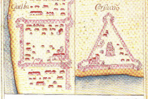
The city of Khor Fakkan (Corfação) is located along the east coast of the United Arab Emirates (25°20’N – 56°22’E). Here, the Portuguese, around 1620, built a triangular fortress with triangular bastions and a round tower in the center.

In the log book of the Dutch vessel the Meerkat (1666) we read: “Gorfacan is a place on a small bay, which has about 200 small houses all built from date branches, near the beach. It had on the northern side a triangular Portuguese fortress, of which the desolate ruins can still be seen. On the southern coast of the bay in a corner there is another fortress on a hill, but there is no garrison nor artillery on it, and it is also in ruins.”

Just 35 km south of Khor Fakkan is the town of Quelba (Kalba). Here on March 1624 the Portuguese built a square fortress.

Portuguese forts of Quelba and Corfacão from Prof. Rui Carita Lyvro de Plantaforma das Fortalezas da Índia

For the image thanks to Prof. Nuno Varela Rubim and Prof. Rui Carita (“O Lyvro de Plantaforma das Fortalezas da Índia, na Fortaleza de S. Julião da Barra, com 22 plantas de anónimo (I Manuel Godinho de Erédia, de cerca de 1620), e 55 plantas de anónimo (II de cerca de 1640)”).

Quelba and Corfação. Text of the document from Prof. Rui Carita Lyvro de Plantaforma das Fortalezas da Índia
Categories
Oman Portuguese Colonialism

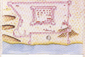
The Portuguese fort of Matrah (Matara)

Situated in a natural harbour near the Oman capital Muscat, tha city of Matrah (Matara).

The Portuguese built a fort in Matrah in 1588, the fort was part of the defenses of the city of Muscat.

The Portuguese controlled the fort between 1588 and 1648.

The fort at Matrah was a square fort with four bastions at the corners.

Portuguese fort of Matarâ (Matrah) from Prof. Rui Carita Lyvro de Plantaforma das Fortalezas da Índia

For the image thanks to Prof. Nuno Varela Rubim and Prof. Rui Carita (“O Lyvro de Plantaforma das Fortalezas da Índia, na Fortaleza de S. Julião da Barra, com 22 plantas de anónimo (I Manuel Godinho de Erédia, de cerca de 1620), e 55 plantas de anónimo (II de cerca de 1640)”).

Matara. Text of the document from Prof. Rui Carita Lyvro de Plantaforma das Fortalezas da Índia
Categories
Oman Portuguese Colonialism

The Portuguese fort of Soar

The city of Sohar (24 ° 21’N – 56 ° 43’E) is located along the Omani coast about 200 km north-west of Muscat.

The Portuguese came to Soar in 1507 and made ​​the city tributary. After several rebellions, the Portuguese retook the city in 1516 and again in 1523.

The Portuguese fortified Soar probably between 1559 and 1561 building a square fortress with bastions and surrounded by walls.

The city was lost by the Portuguese on 7 November 1643.

Portuguese fort of Soar from Prof. Rui Carita Lyvro de Plantaforma das Fortalezas da Índia

For the image thanks to Prof. Nuno Varela Rubim and Prof. Rui Carita (“O Lyvro de Plantaforma das Fortalezas da Índia, na Fortaleza de S. Julião da Barra, com 22 plantas de anónimo (I Manuel Godinho de Erédia, de cerca de 1620), e 55 plantas de anónimo (II de cerca de 1640)”).

Soar. Text of the document from Prof. Rui Carita Lyvro de Plantaforma das Fortalezas da Índia
Categories
Oman Portuguese Colonialism

The Portuguese fort of Sibo

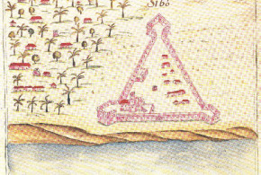
Sibo (As Sib) (23°40’N – 58°12’E) is a coastal town located along the Oman coast 50 km north-west of Muscat, where the Portuguese in the 17th had a triangular fortress with bastions in the angles.

Here a description of this fort extracted from António Bocarro “O livro das plantas de todas as fortalezas, cidades e povoações do Estado da Índia Oriental”:

DISCRIPSSÃO DO FORTE DE SIBO: “Quatro legoas de Mascate correndo a mesma costa, ao noroeste, junto a hum palmar, na costa brava, está situado o forte que chamão Sibo, que he ja antigo, feito pellos arabios. E o procurou senhorear o Capitão Geral Rui Freire d’Andrade, como fes, por ser hum dos caminhos por onde dessem fazendas a Mascate e se recebem outras que se despendem na Arabia. Está feito em modo de triangulo, com tres baluartes nos tres cantos, hum mais eminente que os dous, onde mora o capitão. Os panos de muro, cada hum sera de des pera doze paços geometrios. Tem algûa artelharia meuda de falcõis, e lhe asiste o capitão portugues e trinta lascarins, que o vigião e defendem, cuja despeza se sostenta a mayor parte com o rendimento da terra, e só o capitão he pago do rendimento de Mascate ou da parte das rendas que os xeques tinhão na Alfandega, que pera este e outros beneficios largarão à Fazenda de Sua Magestade.” From: António Bocarro “O livro das plantas de todas as fortalezas, cidades e povoações do Estado da Índia Oriental”

Portuguese fort of Sibo from Prof. Rui Carita Lyvro de Plantaforma das Fortalezas da Índia

For the image thanks to Prof. Nuno Varela Rubim and Prof. Rui Carita (“O Lyvro de Plantaforma das Fortalezas da Índia, na Fortaleza de S. Julião da Barra, com 22 plantas de anónimo (I Manuel Godinho de Erédia, de cerca de 1620), e 55 plantas de anónimo (II de cerca de 1640)”).

Sibo. Text of the document from Prof. Rui Carita Lyvro de Plantaforma das Fortalezas da Índia
Categories
Oman Portuguese Colonialism

The Portuguese fort of Muscat (Mascate)

The Portuguese first conquered and sacked Mascate in Oman in 1507. The Portuguese retained the control over Muscat for more than a century. The Turks conquered from the Portuguese Muscat on two occasions: in 1552 and in 1581-1588. The fortifications of Muscat were reinforced by Belchior Calaça in 1588 by order of the governor of Portuguese India Don Manuel de Sousa Coutinho.

The fortifications of the city of Muscat were based on the presence in strategic points of the bay of two imposing fortifications: the Forte do Almirante (Al-Mirani Fort) and the Forte de São João (Al-Jalali Fort), which flank and dominate the entrance to the bay. The Milanese architect Giovanni Battista Cairati since 1590 improved the defenses of the city.

After the loss of the fortress of Hormuz, in 1622, the port of Muscat became the main base of the Portuguese fleet in the Persian Gulf and the Arabian Peninsula.

The Portuguese lost Muscat on 26 Janaury 1650.

Portuguese fort of Mascate from Prof. Rui Carita Lyvro de Plantaforma das Fortalezas da Índia

For the image thanks to Prof. Nuno Varela Rubim and Prof. Rui Carita (“O Lyvro de Plantaforma das Fortalezas da Índia, na Fortaleza de S. Julião da Barra, com 22 plantas de anónimo (I Manuel Godinho de Erédia, de cerca de 1620), e 55 plantas de anónimo (II de cerca de 1640)”).

Categories
Portuguese Colonialism United Arab Emirates

The Portuguese forts of Mada and Libedia

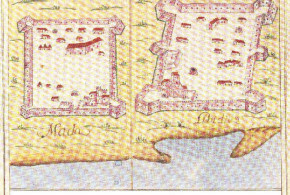
The two fortresses of Mada and Libedia were located along the eastern coast of the present United Arab Emirates.

Libedia has been identified in the present town of Bidyah (25 ° 26’N – 56 ° 21’E) along the coast midway between Fujairah and Dibba.

The two forts were square or rectangular shape with bastions at each corner.

Portuguese forts of Mada and Libedia from Prof. Rui Carita Lyvro de Plantaforma das Fortalezas da Índia

For the image thanks to Prof. Nuno Varela Rubim and Prof. Rui Carita (“O Lyvro de Plantaforma das Fortalezas da Índia, na Fortaleza de S. Julião da Barra, com 22 plantas de anónimo (I Manuel Godinho de Erédia, de cerca de 1620), e 55 plantas de anónimo (II de cerca de 1640)”).

Mada and Libidia. Text of the document from Prof. Rui Carita Lyvro de Plantaforma das Fortalezas da Índia

Categories
Portuguese Colonialism United Arab Emirates

The Portuguese fort of Doba

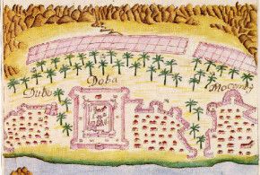
The fortress of Doba, probably the present town of Diba al Hisn (25 ° 36’N – 56 ° 17’E) today in the emirate of Al-Sharjah in the United Arab Emirates, was a square fortress with round bastions and a tower in the center. The Portuguese controlled the city from 1624 to 1648.

Portuguese fort of Doba from Prof. Rui Carita Lyvro de Plantaforma das Fortalezas da Índia

For the image thanks to Prof. Nuno Varela Rubim and Prof. Rui Carita (“O Lyvro de Plantaforma das Fortalezas da Índia, na Fortaleza de S. Julião da Barra, com 22 plantas de anónimo (I Manuel Godinho de Erédia, de cerca de 1620), e 55 plantas de anónimo (II de cerca de 1640)”).

Doba. Text of the document from Prof. Rui Carita Lyvro de Plantaforma das Fortalezas da Índia
Categories
Oman Portuguese Colonialism

The Portuguese forts of Curiate and Sidabo

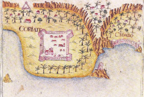
Curiate (Kuriyat/Qurayyat) is a town situated south-east of Muscat along the Oman coast.

The Portuguese fortress of Curiate (Kuriyat/Qurayyat) was rectangular fortress built by the Arabs and conquered by the Portuguese in 1507. The fort was probably rebuilt in the last quarter of the 16th century. The Portuguese lost this fort in 1648.

Here a description of this fort extracted from António Bocarro “O livro das plantas de todas as fortalezas, cidades e povoações do Estado da Índia Oriental”:

DESCRIPÇÃO DA FORTALEZA DE CURIATE: “A fortaleza de Curiate, de Sua Magestade, está doze legoas antes de Mascate pera o Cabo Rosalgate, sita na costa braba, a borda da praya, onde não ha rio nem emceada nenhûa mais que hum ilheo pegado e continuo com a terra firme, que he somente ilheo em lançar ao mar hum outeiro pequeno, o qual em aguoas vivas fica em nado. Neste lugar se abrigão algûas embarcações pequenas de pescadores do sul e sudueste, porque pera mayores não tem fundo. Ao longo delle, está neste ilheo feito hum baluarte, couza pequena, do tamanho de hûa caza, de des paços andantes de praça, em quadro, que se fes pera vigiar daqui artilharia pera o campo e o mar (oje não tem nenhûa). A fortaleza de Curiate que dizemos esta a borda da praya he em quadro não perfeito, senão hum pouco mais comprida que largua, e terá de comprimento, nos dous lanços de muro que vão da praya pera a terra dentro, sincoenta paços andantes e, nos outros dous, de largura (que correm a borda da praya) trinta.” From: António Bocarro “O livro das plantas de todas as fortalezas, cidades e povoações do Estado da Índia Oriental”

Portuguese forts of Curiate and Sidabo from Prof. Rui Carita Lyvro de Plantaforma das Fortalezas da Índia

For the image thanks to Prof. Nuno Varela Rubim and Prof. Rui Carita (“O Lyvro de Plantaforma das Fortalezas da Índia, na Fortaleza de S. Julião da Barra, com 22 plantas de anónimo (I Manuel Godinho de Erédia, de cerca de 1620), e 55 plantas de anónimo (II de cerca de 1640)”).

Curiate and Sidabo. Text of the document from Prof. Rui Carita Lyvro de Plantaforma das Fortalezas da Índia


Categories
Oman Portuguese Colonialism

The Portuguese fort of Borca

Borca was a Portuguese fortress that stood at 12 (?) leagues from Muscat along the coast of Oman. The fortress had a triangular shape with three bastions at the corners of the triangle. In the fortress lived a Portuguese captain with 8 Portuguese soldiers and 30 lascarins.

Probably the Portuguese fort of Borca corresponds to the present city of Barka (23°46’N – 57°46’E) in Oman which is located 65 km north-west of the country’s capital Muscat.

Currently in the town of Barka there are three forts: Fort Barka, which is located a few hundred meters from the beach of the Gulf of Oman. Fort Fulaij a rectangular fort with two towers. The fortification of Beit al-Numan.

Portuguese fort of Borca from Prof. Rui Carita Lyvro de Plantaforma das Fortalezas da Índia

For the images thanks to Prof. Nuno Varela Rubim and Prof. Rui Carita (“O Lyvro de Plantaforma das Fortalezas da Índia, na Fortaleza de S. Julião da Barra, com 22 plantas de anónimo (I Manuel Godinho de Erédia, de cerca de 1620), e 55 plantas de anónimo (II de cerca de 1640)”).

Borca. Text of the document from Prof. Rui Carita Lyvro de Plantaforma das Fortalezas da Índia
Categories
Bahrain Iran Oman Portuguese Colonialism United Arab Emirates

The Portuguese on the Persian Gulf and on the Arabian Peninsula

Written by Marco Ramerini. English text revision by Dietrich Köster

The Portuguese decided shortly after their arrival in the Eastern Seas to prevent the Arabs’ trade by the conquest of Ormuz. For its strategical position, dominating the entrance to the Persian Gulf, Ormuz was one of the two strategical strongholds on the trade routes between the Arab world and Asia (the other being Aden near the Strait of Bab el Mandab). The city of Ormuz (Hormuz) was one of the most important trade centers of the whole East. On its market Persian horses and pearls were exchanged. The town was placed on a dry and barren island near the Persian mainland at the entrance of the Persian Gulf. For nearly 150 years Portugal ruled the Persian Gulf area. Ormuz was regarded by Albuquerque as the third key to the Portuguese Empire in Asia (the other two were Goa and Malacca).

The first attempt to conquer Ormuz was done in 1507 by Afonso de Albuquerque. He, at the head of a small Portuguese fleet of 7 ships and 500 men, proceeded to Ormuz. During the journey he stormed and conquered the towns of Kuryat, Muscat and Khor Fakkan. Differently the towns of Kalhat and Sohar expressed their willingness to become tributary to the King of Portugal. The Portuguese fleet anchored in front of the town of Ormuz. The King of the city was prepared for an attack and he could count on 15,000/20,000 armed men. Albuquerque was resolute and he asked the King to pay a tribute and become a vassal of Portugal, but the King’s reply was evasive, a simple attempt to protract the negotiations. After three days of waiting Albuquerque attacked the city and the King’s fleet was entirely destroyed. Seeing the complete defeat of his forces, the King sent a flag of truce offering to deliver up the city to the Portuguese.

In September 1507 Albuquerque concluded a treaty with the King of Hormuz, under which the King had to pay to the King of Portugal a yearly tribute. After this Albuquerque and his men began to build the fortress, the first stone was laid on 24 October 1507, the fort was named “Nossa Senhora da Victória”.

During the construction of the fortress insubordination arose among the Portuguese. Some Portuguese captains, with the help of the King of Ormuz, rebelled against Albuquerque. In January 1508, after several days of skirmish with the Ormuz’s forces, Albuquerque was forced to abandon the city. This was the first attempt to challenge the Portuguese rule in the Persian Gulf. The second attempt was made in 1515. In March 1515 Albuquerque with a force of 27 ships, 1,500 Portuguese and 700 Malabarese soldiers arrived in front of Ormuz. He was determined to take the town in the name of the King of Portugal and this time he was successful. The fortress was occupied by the Portuguese on 1 April 1515.

Portuguese Fort, Hormuz, Iran. Author Ninara. Licensed under the Creative Commons Attribution-Share Alike
Portuguese Fort, Hormuz, Iran. Author Ninara

The fort was renamed “Nossa Senhora da Conceição”. When the Portuguese arrived, the main ports of the Persian Gulf and Arabia such as Julfar, Bahrain, Calayate (Qalhat), Mascate, Catifa (al Qatif), Corfação and the islands of Queixome and Lareca were all under the jurisdiction of the King of Hormuz. With the fall of Ormuz, all the cities and ports on the Persian Gulf became tributary to Portugal. The kings of Hormuz continued as a regional power in conjunction with the Portuguese. In this way the Portuguese rule began in the Persian Gulf, which lasted till the years 1620/1650.

In a document of the year 1515 (“Rendimento da cidade de Oromuz e seus reinos”) are reported the ports that paid tribute to Portugal. They were: Aigom and Docer “portos que estam na barra de terra firme”, Brahemim “porto que está de fora da ilha d’Oromuz na terra firme”, Tezer “lugar na terra firme”, Beabom, Borate, Jullfar (Julfar), Callayate (Qalhat), Horfacam (Khor Fakkan), Caçapo (Khasab), Broqete “na ilha Qeixa”, Lafete “na ilha Qeixa”, Qeixa “na ilha Qeixa”, Garpez “na ilha Qeixa”, Rodom, Costaque, Chagoa, Callecazei and Lebedia (Al-Bidyah).

“A cidade de Ormuz está situada em hua pequena ilha chamada Gerum que jaz quasi na garganta de estreito do mar Parseo tam perto da costa da terra de Persia que avera de hua a outra tres leguoas e dez da outra Arabia e terà em roda pouco mais de tres leguoas: toda muy esterele e a mayor parte hua mineira de sal e enxofre sem naturalmente ter hum ramo ou herva verde. A cidade em sy é muy magnifica em edificios, grossa em tracto por ser hua escala onde concorrem todalas mercadorias orientaes e occidentaes a ella, e as que vem da Persea, Armenia e Tartaria que lhe jazem ao norte: de maneira que nam tendo a ilha em sy cousa propria, per carreto tem todalas estimadas do mundo /…../ a cidade é tam viçosa e abastada, que dizem os moradores della que o mundo é hum anel e Ormuz hua pedra preciosa engastada nelle” Joao de Barros, Decada II, L. II cap. 2

Portuguese Fort, Hormuz, Iran. Author Fariborz. No Copyright
Portuguese Fort, Hormuz, Iran. Author Fariborz

In 1521 the King of Ormuz rebelled against the Portuguese, but the latter crushed the rebellion and put a new king on the throne. In 1523, Dom Luís de Menezes occupied Soar, which had revolted, and after this, he proceeded to Qeshm, where a new treaty was concluded with the new King and a feitoria was established. In 1526 Lopo Vaz de Sampayo, the Governor of Portuguese India (1526-1529), reduced to obedience Mascate and Khalat, which had revolted. In 1542/43 the entire Customs duties of Ormuz were assigned to the King of Portugal. The years between 1550 and 1560 were years of continued warfare with the Turks for the supremacy in the Persian Gulf. In 1550/51 the Portuguese conquered from the Turks the fort of El Katiff (Al Qatif) in Arabia. In 1551/52, in order to help Ormuz’s defence a fort was built in Mascate. The Turks were determined to take revenge and in 1551/52 they attacked Mascate and sacked the town. In 1559 the Turks besieged the Portuguese fort of Bahrein, but after several months of siege, they were forced to withdraw. In 1581, Mascate was again destroyed by the Turks. In 1582 the King of Lara (Larack, an island near Ormuz), who had revolted, laid siege to the fortress of Ormuz, but the Portuguese succeeded in driving away the invaders and they in turn besieged Lara’s fort of Xamel, which was taken by the Portuguese. Finally, in 1588 the Mascate’s fortresses were again rebuilt. This time the town was also fortified and in nearby Matara (Matrah) a fort was built, too. In 1602 Shah Abbas expelled the Portuguese from Bahrain.

Ormuz used for its provisions of water the wells of Comorão on the Persian coast. Here the Portuguese had a fort. It was conquered by the Persians in 1615 (1614?). In 1616 Soar, which had revolted, was captured by a Portuguese fleet and the King was put to death. In 1619 the Portuguese fortress of Ormuz had a garrison of 500-700 soldiers. The fort of Khawr Fakkan (Corfação) was built in 1620 by Gaspar Leite. On 8 May 1621 Rui Freire de Andrada, the “General do Mar de Ormuz e costa da Persia e Arabia”, began to build a fort in Queixome (Qeshm), this fort was built to have the control of the island’s water wells. The building of this fort was regarded as an act of open hostility by the Shah of Persia, who waged war against the Portuguese. In 1622, the Arabs, who had joined the Persians, succeeded in capturing Julfar from the Portuguese. On 11 February 1622, the Portuguese fort of Queixome, after a feeble resistance, was forced to surrender to a joint Persian-English army. On 20 Febraury 1622 the Persian flotilla of more than 3,000 men with the help of 6 English ships besieged the Portuguese fortress of Ormuz. Ormuz was lost by the Portuguese on 3 May 1622. The entire Portuguese population, about 2,000 persons, were sent to Mascate.

Portuguese Fort, Qeshm, Iran. Author Alborz Fallah. Licensed under the Creative Commons Attribution-Share Alike
Portuguese Fort, Qeshm, Iran. Author Alborz Fallah

During the decade after the fall of Ormuz, the Portuguese, under the command of Rui Freire de Andrada, tried several times (1623, 1624, 1625, 1627) to regain the fortress. The last attempt in 1631 was a diplomatic one, but all these attempts failed. After the loss of Ormuz the Portuguese established their base in Mascate, and in 1623, a feitoria (trading station) was established also in Bassora at the mouth of the Euphrates River. In 1623 Rui Freire reoccupied the fort of Soar, which had been taken in 1622 by the Persians. In the same year a new base was established in Cassapo (Kashab) on the Musandam Peninsula. Kalba (Quelba) was conquered by Gaspar Leite in 1624. The fort of Mada was conquered in May 1624 by Mateus de Siebra. In 1624/25, following a treaty with the Persians, a feitoria and a fortress were established in Congo (Bandar-e Kong) on the Persian coast of the Persian Gulf. In 1631 a Portuguese fortress was built in Julfar, an important strategic point on the Musandam Peninsula. This town enjoyed during Portuguese rule great prosperity as the regional trading entrepôt. In September 1633 Rui Freire de Andrada, the great protagonist of these years, died and his body was buried in the church of St. Agostinho in Mascate. In 1633/35 peace treaties were concluded with the English and the Persians.

The Portuguese rule in the Persian Gulf was nearly more stable after the loss of Ormuz than before. In fact several fortresses and feitorias in a lot of places such as Soar, Julfar, Doba, Libedia, Mada, Khor Fakkan, Caçapo (Khasab), Congo (Kung) and Bassora were established. In August 1648, the Arabs besieged Mascate and on 31 October a treaty was signed between the two opponents. The terms were as follows: the Portuguese should raze to the ground the fortress of Kuriyat, Doba and Matara. In January 1650 Mascate, the last Portuguese base in Arabia, was taken by the Omanites. By the loss of Mascate the Portuguese were deprived of their last stronghold in the vicinity of the Persian Gulf and thus the so-called “Portuguese period” came to an end on the Persian Gulf.

BIBLIOGRAPHY:

– Al-Khalifa, Shaikh Abdullah Bin Khalid and Abahussain, Dr. Ali “Bahrain Through The Ages – Vol.2” Historical Documents Centre, 1995, Bahrain

– Al Maamiry, Ahmed Hamoud “Omani – Portuguese history” 80 pp. ills. Lancers Publishers, 1982, New Delhi, India.

– Andrada, Ruy Freyre de “Commentaries of Ruy Freyre de Andrada” ? Edited with an Introduction by C.R. Boxer. 328 pp. Robert M. McBride & Co., 1930, NY, USA.

– Barendse, R. J. “The Arabian Seas, 1640-1700” vi + 465 pp. Leiden University, 1998, Leiden, NL.

– Boxer, Ch. R. “Anglo-Portuguese Rivalry in the Persian Gulf, 1615-1635” In: Boxer, Ch. R. “Portuguese conquest and commerce in Southern Asia 1500-1750” 1985, London, UK.

– Costa, Paolo M. “Historical interpretation of the territory of Muscat” In: Various Authors “Oman studies: papers on archeology and history of Oman” 203 pp. Istituto Italiano per il Medio e l’Estremo Oriente, 1989, Roma, Italia. pp. 97-117

– Costa, Paolo “Musandam: Architecture and Material Culture of a Little Known Region of Oman” ? 250 pp. Vine House, 1995,

– Dias Farinha, António “Os Portugueses no Golfo Pérsico 1507-1538 ” 266 pp. Dissertação Faculdade de Letras da Universidade de Lisboa 1990 Lisboa. Also in: Mare Liberum, Revista de História dos Mares Nº 3 , pp. 1-159, 1991, Lisbon, Portugal. This book contains a vast collection of documents about the first years of Portuguese presence in the Persian Gulf.

– Dinteman, Walter “Forts of Oman” 128 pp., numerous col. photogrs. 1993. A highly pictorial account of the role of the fort in Oman’s history since the 16th century.

– Gonçalves, Julio “Mascate, Albuquerque e os sultanatos do Omã 1507-1659” In: “Anais” do Clube Militar Naval, pp. 421-435 1940, Lisboa, Portugal.

– Kervran, Monik (ed.) “Bahrain in the XVIth Century. An Impregnable Island” 93 pp. ills., plans and maps Ministry of Information State of Bahrain, 1988, Bahrain. pp. 7-34

– Kervran, Monik; Negre, Arlette; Michele Pirazzoli “Excavation of Qal’at al -Bahrain 1st Part (1977-1979)” 119 pp, plans, b&w & col photos Ministry of Information, 1982, Bahrain.

– Kleiss, Wolfram “Die portugiesische Seefestung auf der Insel Hormuz am. Persischen Golf” Architectura, Munich 1978:8 166-183

– Muir, J. “Reminiscências Portuguesas na Arábia Oriental” 13 pp. Separatas do Boletim da Sociedade de Geografia de Lisboa 1961 Lisboa, Portugal.

– Ozbaran, Salih “The Ottoman Turks and the Portuguese in the Persian Gulf (1534-1581)” ? Thesis University of London, 1969, London, UK.

– Ozbaran, Salih “The Ottoman response to European Expansion. Studies on Ottoman-Portugese relations in the Indian Ocean and Ottoman administration in the Arab lands during the Sixteenth Century” xv, 222 pp. b/w ills., 4 maps, Analecta Isisiana XII, The Isis Press, 1994, Istanbul, Turkey. The complete collection of English articles written by Salih Özbaran from 1972 till 1993.

– Risso, Patricia “Oman and Muscat: an early modern history” ? xvii + 258 pp. Croom Helm, 1986, London, UK.

– Serjeant, R. B. “The Portuguese off the South Arabian Coast: Hadrami chronicles. With Yemeni and European accounts of Dutch pirates off Mocha in the seventeenth century” XIV, 233 pp. With 2 maps and 14 plates, 1974, Beirut, Lebanon. Clarendon, 1963, Oxford

– Slot, B. J. “The Arabs of the Gulf 1602-1784” ? xvii + 436 pp. Slot, 1993, Leidschendam.

– Vine, Peter; Casey and Vine, Paula (eds.) “Oman in history” 560 pp. Immel Publishing, 1995, London, UK.

– Ziolkowski, Michele “Al Bidyah excavations, 1999” In: “BSAI Nesletter” n°4, November 1999, British School of Archeology in Iraq.

Categories
Colonial Forts on Google Earth Oman Portuguese Colonialism

The Portuguese Forts in Oman

Written by Marco Ramerini. Photos by Fritz Gosselck. English text revision by Dietrich Köster.

Oman is a country rich in fortifications, some of these were built along the Omani coast by the Portuguese in the sixteenth and seventeenth century, often altered from the original forms several forts built or modernized by the Portuguese are still visible today.

Two impressive fortresses are located in the capital of the Sultanate, Muscat, these are the forts of Jalali (São João) and Mirani both built by the Portuguese around 1580. A few kilometers away is the fort of Matrah also built by the Portuguese in the late sixteenth century.

On the Musandam peninsula in the far north, overlooking the Strait of Hormuz, is the village of Khasab, where another fort was built by the Portuguese around 1620.

Suwayq Fort, Oman (photo © by Fritz Gosselck).

BIBLIOGRAPHY:

– Al Maamiry, Ahmed Hamoud “Omani – Portuguese history” 80 pp. illustrations, Lancers Publishers, 1982, New Delhi, India.

– Andrade, Rui Freire de “Comentários do Grande Capitão Rui Freire de Andrade” XII, 374 pp. [3] maps Ministério das Colónias, Agência Geral das Colónias 1940 Lisbon, Portugal.

– Dias Farinha, António “Os Portugueses no Golfo Pérsico 1507-1538” 266 pp., Dissertação Faculdade de Letras da Universidade de Lisboa, 1990, Lisbon.

– Dinteman, Walter “Forts of Oman” 128 pp., colour photographs . 1993.

– Gonçalves, Júlio “Mascate, Albuquerque e os sultanatos do Oman 1507-1659” In: “Anais” do Clube Militar Naval, pp. 421-435, 1940, Lisbon, Portugal.

– Muir, J. Reminiscências Portuguesas na Arábia Oriental” 13 pp. Separata do Boletim da Sociedade de Geografia de Lisboa 1961 Lisbon, Portugal.

– Ozbaran, Salih “The Ottoman response to European Expansion. Studies on Ottoman-Portugese relations in the Indian Ocean and Ottoman administration in the Arab lands during the sixteenth Century” xv, 222 pp. black-and-white illustrations, 4 maps, Analecta Isisiana XII, The Isis Press, 1994, Istanbul, Turkey.

– Risso, Patricia “Oman and Muscat: an early modern history” xvii + 258 pp., Croom Helm, 1986, London, United Kingdom.

– Vine, Peter; Casey and Vine, Paula (editors) “Oman in history” 560 pp., Immel Publishing, 1995, London, United Kingdom.